A free Premium account on the FCL.055 website! Read here
Sign up to unlock all our services and 15164 corrected and explained questions.
Question 89-1 : Which of the following is unlikely to have any effect on the position of the centre of gravity on an aeroplane in flight ? [ Validation Marking ]
Changing the tailplane horizontal stabiliser incidence angle
Question 89-2 : When the centre of gravity is at the forward limit an aeroplane will be ?
Extremely stable and will require excessive elevator control to change pitch.
When the cg is located on the forward limit the pitch down moment is at its allowed maximum the distance between cg and cp is great the elevator will have to develop a high downward force to counteract this pitch down moment and it will seem heavier to the pilotof course the aircraft will be extremely stable which is the good news about a forward cgExtremely stable and require small elevator control to change pitch. extremely unstable and require excessive elevator control to change pitch. extremely unstable and require small elevator control to change pitch.
Question 89-3 : A mass of 500 kg is loaded at a station which is located 10 metres behind the present centre of gravity and 16 metres behind the datum assume g=10 msec squared the moment for that mass used in the loading manifest is ?
80000 nm.
Arm = moment forcethus moment = arm x force16 m x 5000 n = 80000 nm30000 nm. 50000 nm. 130000 nm.
Question 89-4 : Without the crew the mass and longitudinal cg position of the aircraft are 6000 kg and 470m the mass of the pilot is 90 kg the mass of the copilot is 100 kg the mass of the flight engineer is 80 kgwith the crew the mass and longitudinal cg position of the aircraft are 220 ?
6270 kg and 4594 m.
Moment = 6000 x 47 = 28200 kgmpilot 90 kg > moment is 184 kgmco pilot 100 kg > moment 204 kgmflight engineer 80 kg > moment column b is 215 kgmtotal moment = 28200 + 184 + 204 + 215 = 28803 kgmtotal mass = 6000 + 90 + 100 + 80 = 6270 kgcg = momentmasscg = 288036270 = 4594 m6270 kg and 5.012 m. 6270 kg and 4.61 m. 6270 kg and 4.796 m.
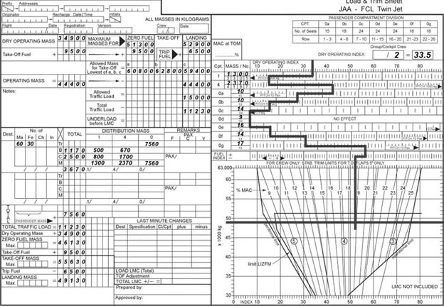
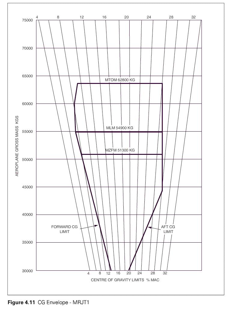
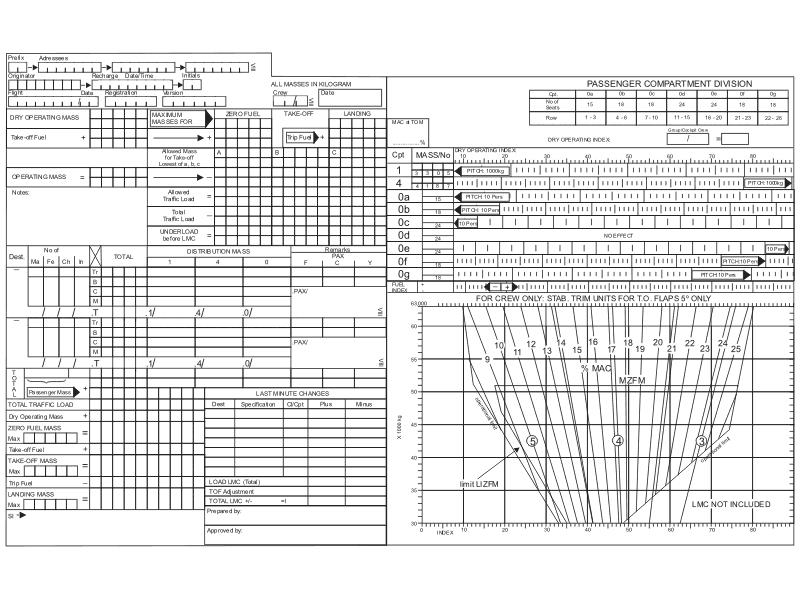
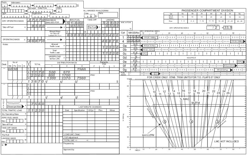
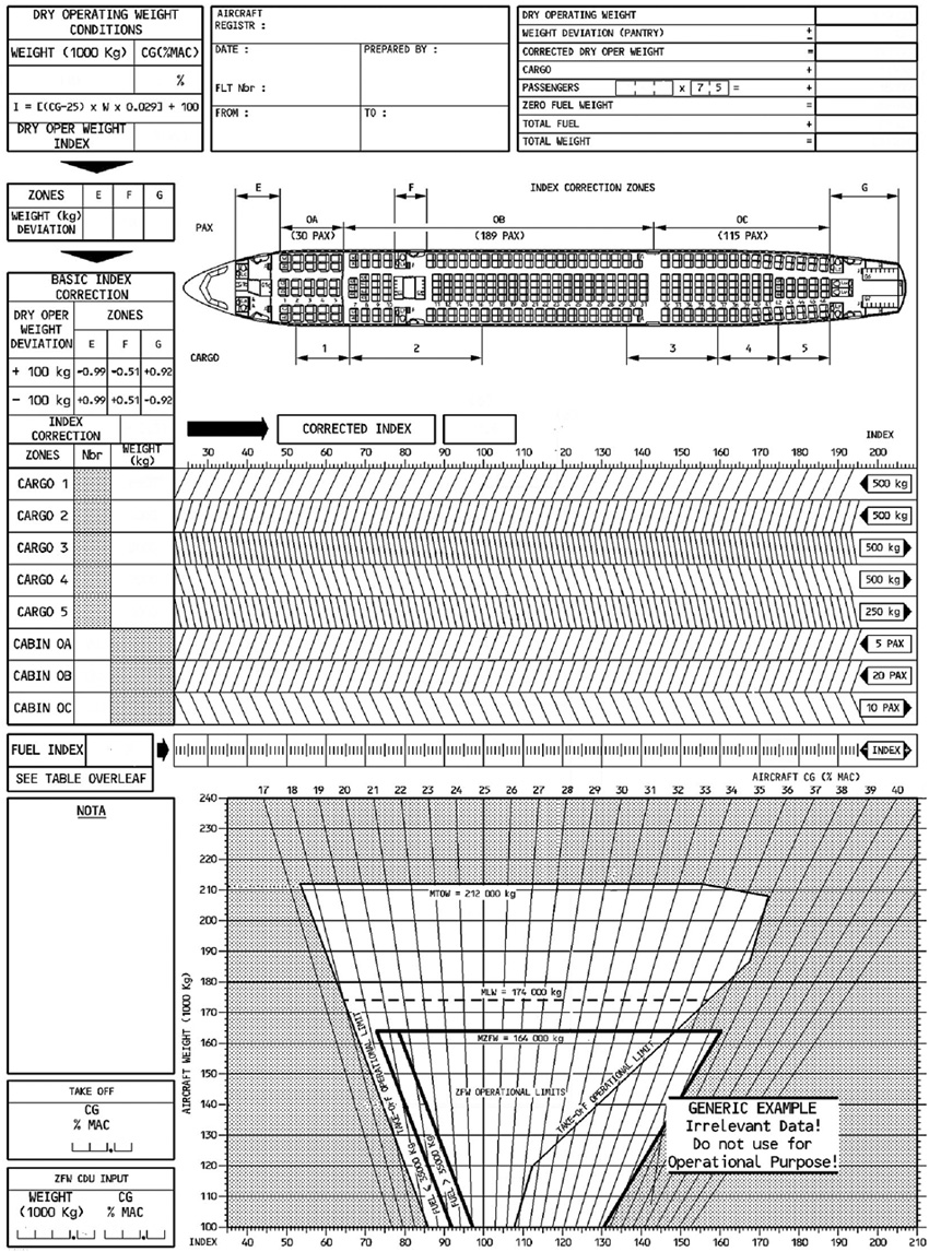
Question 89-5 : Using the load and trim sheet for the mrjt1 aircraft which of the following is the correct value for the index at a dry operating mass dom of 35000 kg with a cg at 14% mac 221 ?
400.
Img16935.5 41.5 33.0
Question 89-6 : Using the data given in the load and trim sheet determine which of the following gives the correct values for the zero fuel mass and position of the centre of gravity % mac at that mass 222 ?
46130 kg and 178%.
Img16146130 kg and 20.8%. 51300 kg and 20.8%. 41300 kg and 17.8%.
Question 89-7 : Using the data given in the load and trim sheet determine from the following the correct values for the take off mass and the position of the centre of gravity at that mass if the fuel index correction to be applied is given as 09 223 ?
175%.
Img16220.3%. 22.6%. 20.1%.
Question 89-8 : Using the data given at the appendix to this question if the fuel index corrections from zfm index are as follows 9500 kg 096500 kg 613500 kg 473000 kg 43which of the following represent the correct values for landing mass of the aeroplane and the position of the centre of gravity for this ?
49130 kg and 19%.
Img163first complete the load calculation then complete the graph do not forget to apply 'fuel index correction of 43' 3000 kg of fuel remain in tank at landing at the end52900 kg and 21.6%. 49130 kg and 21.8%. 52900kg and 19%.
Question 89-9 : Using the data given at the appendix determine which of the following correctly gives the values of the zero fuel mass zfm of the aeroplane and the load index at zfm 225 ?
48600 kg and 570.
Zero fuel mass zfm = dry operating mass + traffic load = 37370 kg + 11230 kg = 48600 kgwe have only one answer with this value of zero fuel mass zfm no need to go further in the graph51300 kg and 57.0. 46300 kg and 20.5. 35100 kg and 20.5.
Question 89-10 : For this question use annex ecqb 031 mb 02 v2015 03 from the data given at the appendix and assuming a fuel index shift of 57 from the zfm loaded index determine which of the following is the correct value percentage mac for the position of the centre of gravity at take off mass 226 ?
18%.
Img16419%. 15%. 14%.
Question 89-11 : From the data contained in the attached appendix the maximum allowable take off mass and traffic load is respectively 227 ?
61600 kg and 12150 kg.
Img16568038 kg and 18588 kg. 66770 kg and 17320 kg. 60425 kg and 10975 kg.
Question 89-12 : An aeroplane is carrying a traffic load of 10320 kgcomplete the necessary sections and determine which of the answers given below represents the maximum increase in the traffic load 228 ?
1830 kg.
Img166655 kg. 7000 kg. 8268 kg.
Question 89-13 : When has the centre of gravity to be computed ?
Prior to every flight.
After every 400 hours inspection. at least every 4 years. during every yearly inspection.
Question 89-14 : What mass has to be entered in the loading chart for aviation fuel f 34 if 170 l may be refuelled fuel density = 078 kgl ?
133 kg.
170 litres x 078 = 1326 kgfor information aviation fuel f 34 is a military kerosene type turbine fuel with fuel system icing inhibitor133 dan. 170 kg. 218 kg.
Question 89-15 : An aeroplane with a two wheel nose gear and four main wheels rests on the ground with a single nose wheel load of 500 kg and a single main wheel load of 6000 kgthe distance between the nose wheels and the main wheels is 10 meterhow far is the centre of gravity in front of the main wheels ?
40 cm.
Total airplane weight = 500 x 2 + 6000 x 4 = 25 000 kgthe center of gravity at this weight is located at 1000 kg x 10 m 25 000 kg = 04 m in front of the main wheels25 cm. 4 m. 41.6 cm.
Question 89-16 : Using the reference provided without the crew the weight and the cg position of the aircraft are 7 000 kg and 470mthe mass of the pilot is 90 kg the mass of the co pilot is 75 kg and the mass of the flight engineer is 90 kgwith this crew on board the cg position of the aircraft will be 231 ?
4615 m.
Take the moments individually pilot 184 kgmcopilot 153 kgmflight engineer column b 242 kgmbasic empty mass moment 7000 x 47 = 32900 kgmtotal moment 33479 kgmtotal mass 7000 + 90 + 75 + 90 = 7255 kgcg = momentmass = 334797255 = 4615 m0.217 m. 4.783 m. 4.455 m.
Question 89-17 : Given that the flight time is 2 hours and the estimated fuel flow will be 1050 lh and the average oil consumption will be 225 lhthe specific density of fuel is 079the specific density of the oil is 096the 'freight 2' will be dropped during flight within the scope of a rescue actioncalculate the cg ?
24 cm aft of datum.
Take off mass is 19339 kgminus fuel = 2100 x 079 = 1659 kgminus oil = 45 liter x 096 = 432 kgminus 'freight 2' = 410 kgour landing mass will be = 1726568 kgtake off moment is 392350 kgcm fuel moment = 1659 x 8 cm = +13272 kgcm oil moment = 432 x 40 cm = 1728 kgcm 'freight 2' moment = 410 x 40 cm = +16400 kgcmtotal moment at landing = 4218492 kgcmthe cg position at landing = 4217692 kgcm 1726568 kg = 2442 cm25 cm aft of datum. 22 cm aft of datum. 27 cm aft of datum.
Question 89-18 : An aeroplane with a two wheel nose gear and four main wheels rests on the ground with a single nose wheel load of 725 kg and a single main wheel load of 6000 kgthe distance between the nose wheels and the main wheels is 10 metershow far is the centre of gravity in front of the main wheels ?
57 cm.
Total mass 725 kg x 2 + 6000 kg x 4 = 25450 kgthe distance between the nose wheels and the main wheels is 10 metersthe centre of gravity in front of the main wheels is at centre of gravity = total moment total masscentre of gravity = 1450 kg x 10 m 25450 kg = 05697 m93 cm. 108 cm. 176 cm.
Question 89-19 : An aeroplane has a planned take off mass of 200 000 kgits cg is located at 1538 m of the reference point representing a cg location at 30% mac mean aerodynamic cord moment arm of the forward cargo is 15 mmoment arm of the aft cargo is 25 mfor performance purposes the value of the centre of gravity ?
4600 kg.
Length of the mean aerodynamic chord = 14 + 46 14 = 46 mchange in cg = 30% vers 35% = 5%5% of the mac lenght = 5% de 46 = 023 mchange in mass total mass = change in cg total distance movedchange in mass = change in cg x total mass total distance movedchange in mass = 023 m x 200000 kg 10 mchange in mass = 4600 kg5600 kg. 3600 kg. it is impossible to move the cg at the requested value.
Question 89-20 : The index method in mass and balance calculations is used for ?
Reducing the magnitude of the moment.
In mass and balance calculations the 'index' is a figure without unit of measurement which represents a momentthe value of the index is the moment divided by a constant usually 1000 it is used to simplify the calculations by decreasing the valuesReducing the magnitude of the useful load. increasing the magnitude of the useful load. increasing the magnitude of the moment.
Question 89-21 : What are the advantages of using the index method to determine moments it ?
Reduces the magnitude of the moments making it less time consuming to compute.
Is digitalised and can be automatically uploaded to the aircraft fmc to determine stabiliser trim setting. directly produces the position of the cg and the stabiliser trim setting. enabled the pilots to calculate the position of the cg by mental arithmetic and thereby expedites mass and balance calculations.
Question 89-22 : What is the principle of the index method ?
To divide high magnitude moments by a constant and make result more easier to use.
Ecqb03 july 2016To refer every item of the aircraft to a position called the ba (balance arm). to compute the cg position and stabiliser trim setting without completing a load sheet. to round all values for easier and much faster calculation.
Question 89-23 : Define the 'under load' ?
Allowed tom dom useful load.
Actual tom - dom - useful load allowed tl - tom actual tl - tom
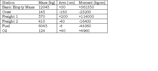
Question 89-24 : For this question use annex ecqb 031 046 v2015 01 the aircraft is loaded as shown in the tablecalculate the new total moment if the mass of the crew is increased 240 ?
300000 kgmm.
Ecqb03 july 2016 sorry we haven't yet recovered the annex we get only the question and the correct answer this is nice isn't it30000 kg.mm 34800 kg.mm 348000 kg.mm
Question 89-25 : The planned take off mass of a turbojet aeroplane is 180 000 kg with its centre of gravity located at 26 % mac mean aerodynamic cord shortly prior to engine start the local staff informs the flight crew that 4 000 kg must be unloaded from cargo 4 after the handling operation the new centre of ?
221 %.
Img com encom031 291jpg30.0 %. 21.1 %. 24.2 %.
Question 89-26 : A turbojet aeroplane has a planned take off mass of 190 000 kg following cargo loading the crew is informed that the centre of gravity at take off is located at 38 % mac mean aerodynamic cord which is beyond limits the captain decides then to redistribute part of the cargo load between cargo 1 and ?
3000 kg from cargo 4 to cargo 1.
Img com encom031 292jpg2000 kg from cargo 4 to cargo 1 1000 kg from cargo 4 to cargo 1 it is not possible to obtain the required centre of gravity.
Question 89-27 : The planned take off mass of an aeroplane is 190 000 kg with its centre of gravity located at 29 % mac mean aerodynamic cord shortly prior to engine start the local staff informs the flight crew that an additional load of 4 000 kg must be loaded in cargo 4 after loading this cargo the new centre of ?
322 %.
31 %. 27 %. 25 %.
Question 89-28 : The planned take off mass of an aeroplane is 180 000 kg with its centre of gravity located at 31 % mac mean aerodynamic cord shortly prior to engine start the local staff informs the crew that an additional load of 4 000 kg must be loaded in cargo 1 after loading this cargo the new centre of ?
25%.
34%. 38%. 21%.
Question 89-29 : What is dry operating index doi ?
The index for the position of the centre of gravity at dry operating mass.
Dry operating index doi is the index for the position of the centre of gravity at dry operating massdry operation mass dom is the total mass of the aeroplane ready for a specific type of operation excluding usable fuel and traffic load the mass includes items such as i crew and crew baggageii catering and removable passenger service equipmentiii potable water and lavatory chemicalsiv food and beveragesbalance arm ba is the distance from datum to the centre of gravity of a masscentre of gravity cg is that point through which the force of gravity is said to act on a massmoment is the product of the mass and balance armThe distance from datum to the centre of gravity of a mass. the point through which the force of gravity is said to act on a mass. the product of the mass and balance arm.
Question 89-30 : A 3 m long plank is on a pivot halfway along its length a 1 kg mass is suspended on the left end and a 2 kg mass from other endhow far and in which direction should the plank be moved in order for the plank to be in balance ?
05m to the left.
Moment = mass x balance arm1 kg x 15 m = 15 kgm2 kg x 15 m = 3 kgmthe 1 kg mass must have the same moment than the 2 kg mass for the plank to be in balance 1 kg x 2 m = 2 kg x 1 m2 kgm = 2 kgm0.5m to the right. 1m to the left. 1m to the right.
Question 89-31 : For the following see saw to be in balance with a mass of 35 kg suspended on the left end 14m left of pivot and 75 kg suspended on the right end the mass required at position 5m left of the pivot must be 247 ?
22 kg.
14m x 35 kg + 5m x = 8m x 75 kg = 8 x 75 14 x 35 5 = 600 490 5 = 22 kg136 kg. 57 kg. 14 kg.
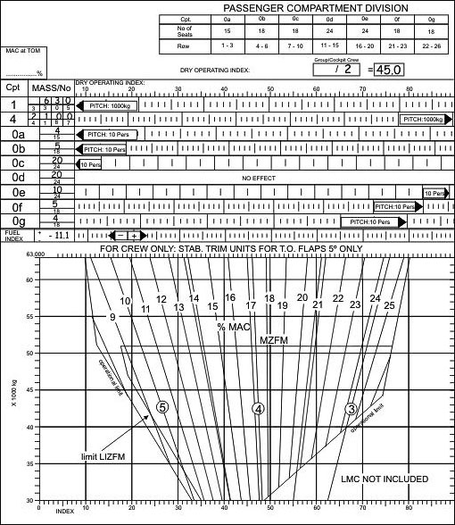
Question 89-32 : Refer to figure 031 13for a medium range twin jet aircraft with a cg located at 18% mac at 62000 kg gross mass determine the stabilizer trim units required for a take off flap setting of 15° ?
30.
2.5 3.25 2.75
Question 89-33 : Consider a conventional aircraft with three wheels the nose jack is located 161 inches aft of the datum the main wheel jacks are located 775 inches aft of the datum after weighing the following results are reported nose jack 2300 lbeach main wheel jack 19300 lbwhat is the basic empty mass of the ?
Bem 40900 lb cg 7405 in.
Bem 21600 lb, cg 722.3 in. bem 40900 lb, cg 722.3 in. bem 21600 lb, cg 709.6 in.
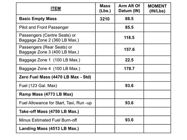
Question 89-34 : Refer to figure 031 57calculate the cg position and moment for the basic empty mass by using the data given from the attached table ?
1157 in aft of datum and the moment is 365074 inlb.
111.4 in aft of datum and the moment is 489666 in.lb 95.3 in aft of datum and the moment is 380373 in.lb 113.6 in aft of datum and the moment is 430998 in.lb
Question 89-35 : The mass and the cg of an aircraft must be established by actual weighing by the ?
Operator prior to initial entry into service.
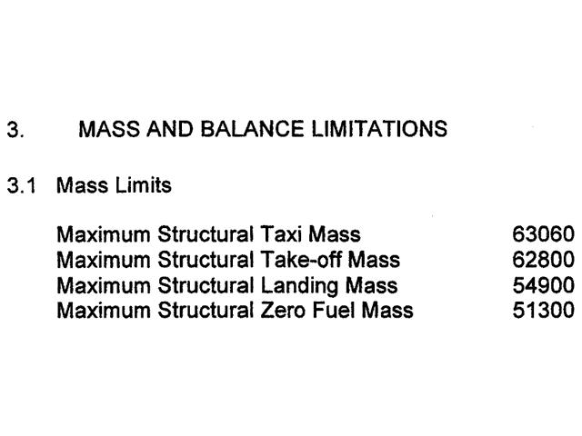
Easa air opsregulation eu no 9652012catpolmab100 mass and balance loading a during any phase of operation the loading mass and centre of gravity cg of the aircraft shall comply with the limitations specified in the afm or the operations manual if more restrictive b the operator shall establish the mass and the cg of any aircraft by actual weighing prior to initial entry into service and thereafter at intervals of four years if individual aircraft masses are used or nine years if fleet masses are used the accumulated effects of modifications and repairs on the mass and balance shall be accounted for and properly documented aircraft shall be reweighed if the effect of modifications on the mass and balance is not accurately known c the weighing shall be accomplished by the manufacturer of the aircraft or by an approved maintenance organisation d the operator shall determine the mass of all operating items and crew members included in the aircraft dry operating mass by weighing or by using standard masses the influence of their position on the aircraft's cg shall be determined e the operator shall establish the mass of the traffic load including any ballast by actual weighing or by determining the mass of the traffic load in accordance with standard passenger and baggage masses f in addition to standard masses for passengers and checked baggage the operator can use standard masses for other load items if it demonstrates to the competent authority that these items have the same mass or that their masses are within specified tolerances g the operator shall determine the mass of the fuel load by using the actual density or if not known the density calculated in accordance with a method specified in the operations manual h the operator shall ensure that the loading of 1 its aircraft is performed under the supervision of qualified personnel and 2 traffic load is consistent with the data used for the calculation of the aircraft mass and balance i the operator shall comply with additional structural limits such as the floor strength limitations the maximum load per running metre the maximum mass per cargo compartment and the maximum seating limit for helicopters in addition the operator shall take account of in flight changes in loading j the operator shall specify in the operations manual the principles and methods involved in the loading and in the mass and balance system that meet the requirements contained in a to i this system shall cover all types of intended operationsOwner operator before the first flight of the day. pilot on entry of aircraft into service. engineers before commencing service.
Question 89-36 : Refer to figure 031 59the see saw is in a state of equilibrium calculate the distance between a and c ?
3049 m.
Admin left side must be equal to right side = moment on the left side must be equal to moment on the right side 520kg x 8m = 48kg x 7m + 170 kg x x x is the distance between the pivot to mass cx = 520kg x 8m 48kg x 7m 170x = 4160 336 170 = 2249 mdistance between a and c is 8 m + 2249 m = 3049 m37,1 m. 29,49 m. 22,49 m.
Question 89-37 : Given length of the mac 114 inchesforward gc limit 12% macaft cg limit 38% maccalculate the distance of cg at 10m mac with reference to the forward limit ?
228 inches.
8.77 inches. 25.08 inches. 10.53 inches.
Question 89-38 : Consider a conventional aircraft with three wheels the nose jack is located 161 inches aft of the datum the main wheel jacks are located 775 inches aft of the datum after weighing the following results are reported nose jack 6488 lbeach main wheel jack 17783 lbwhat is the basic empty mass of the ?
Bem 42054 lb cg 6803 in.
Bem 24271 lb, cg 610.9 in. bem 42054 lb, cg 570.3 in. bem 24271 lb, cg 936 in.
Question 89-39 : Refer to figure 031 61originally there has been 225 l of fuel in the tank of the aircraft but the pilot decides do add 200 kg of additional fuel what will happen to the centre of gravity ?
The cg will move towards the nose of the aircraft.
The cg will move towards the tail of the aircraft. the cg will move towards the bottom of the aircraft. the cg will remain the same.
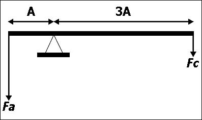
Question 89-40 : Refer to figure 031 05given force fa 100 ndistance a 6 mdistance b 3 mcalculate force fb to obtain equilibrium ?
200 n.
300 n. 50 n. 100 n.
Exclusive rights reserved. Reproduction prohibited under penalty of prosecution.