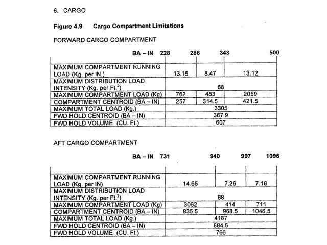
A free Premium account on the FCL.055 website! Read here
Sign up to unlock all our services and 15164 corrected and explained questions.
Question 102-1 : With regard to the effect of altitude on the speed for maximum endurance for a propeller driven aeroplane as altitude increases the speed for maximum endurance will… ? [ Exam pilot ]
Increase because the power required increases with altitude
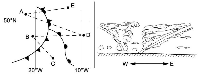
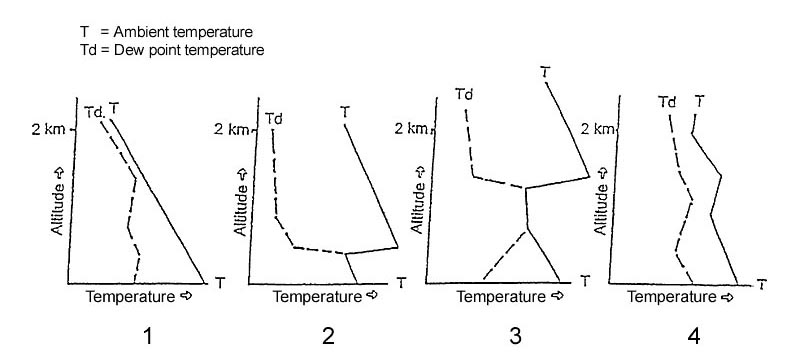
Question 102-2 : A turbojet aeroplane in straight and level flight is cruising at fl290 for a given mass and cg position how will the high speed buffet and low speed buffet as an ias vary when the flight is operated at fl330 ?
The low speed buffet increases and the high speed buffet decreases.
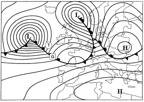
before the days of fms the buffet boundary was displayed on a chart the buffet boundary has both low and high speed limits the low speed buffet boundary describes the ias at which we find the onset of the pre stall buffet at a 10% margin above vs the high speed buffet boundary describes the ias at which we find the onset of mach related buffet normally mmo but sometimes slightly below thatat low altitudes these speeds are far apart leaving a wide range of operating speeds although stalling ias remains constant at first as altitude increases it starts to increase at higher altitudealso the ias at which we get mach buffet will steadily decrease because tas increases in the climb and local speed of sound decreases the two buffet boundaries will move closer toogether and eventually meet at an altitude where no margins exists the coffin corner or aerodynamic ceiling ie you cannot fly faster or slower because you will either stall or hit mmothe right hand limit on the graph shows the maximum indicated airspeed vmo and then at high altitude the maximum mach number mmo the left hand limit is based on the stall speed 11 vstherefore with increasing altitude the low speed buffet will increase and the high speed buffet will decreaseBoth the low-speed buffet and high-speed buffet decrease. both the low-speed buffet and high-speed buffet increase. the low-speed buffet decreases and the high-speed buffet increases.
Question 102-3 : A difference between a reduced flex and a derated thrust take off is that ?
On a flex take off the toga thrust remains available.
When an aircraft has excess performance during takeoff using maximum thrust is unnecessary and choosing a lower thrust setting offers benefits in engine life and costs two procedures exist flex takeoff and derated thrust takeoffthe flex take off is achieved by calculating an assumed or flex temperature that is higher than the ambient which will when entered into the fms give a thrust setting lower than full thrust the flex temperature will always be higher than the ambient temperature on a flex take off the reduced thrust setting for take off will not need to be increased if there is an engine failure but in emergency it can be full thrust may be applied at any timeaccording to amc 25 13 'when operating with reduced flex take off thrust the thrust setting parameter which establishes thrust for take off is not considered a take off operating limit'because full thrust can be applied at any time on a flex take off the speeds vmcg and vmca must be corrected for full thrust not the reduced thrust setting a flex take off is not considered to be a normal take off is always at the discretion of the pilot and is not authorised on wet runways unless suitable performance accountability is made for the increased stopping distance on a wet runway as most operators account for this we can assume that flex thrust take offs are allowed on a wet runway but not on a contaminated runway throughout the flex take off a further thrust selection of the take offgo around toga is availablleamc 25 13 defines derated thrust as a take off thrust less than the maximum take off thrust for which exists in the afm a set of separate and independent or clearly distinguishable take off limitations and performance data that complies with all the take off requirements of cs 25 when operating with a derated take off thrust the value of the thrust setting parameter which establishes thrust for take off is presented in the afm and is considered a normal take off operating limita derated thrust take off is considered to be a normal take off and therefore can be carried out both on dry runwaysand on wet and contaminated runways subject to the afm data and other operating restrictionsbecause the take off speeds are calculated at the lower thrust the derated thrust setting is considered to be a limit and therefore full thrust or toga thrust cannot be selected even in an emergency until the hazard area for vmcg is well passed airbus for instance does not allow toga to be selected on a derated take off until the aircraft has achieved the minimum flap retraction speedDerated thrust take-offs use an assumed temperature. the flex thrust is regarded as an operating limit. flex take-offs can be conducted on contaminated runways.
Question 102-4 : Maximum endurance for a turboprop aircraft with a 10 kt headwind is achieved at 1 and the maximum endurance speed 2 ?
1 vmp 2 remains the same.
The best or maximum endurance speed for a propeller driven aircraft is the minimum power speed vmp this is the minimum power required to maintain level flight vmp is always less than the best range speed vmd and therefore speed unstablethe wind does not affect endurance flying but it can affect the range flying(1) vmdxsx (2) reduced (1) vmdxsx (2) remains the same (1) vmpxsx (2) reduced
Question 102-5 : What speed will be limiting with a descent at constant mach ?
Vmo.
At sea level the tas is comparitively low and the speed of sound is quite high at high altitude for a given cas the tas is much higher because the air is thin and the local speed of sound lss is less because it is colderbecause the mach number is tas divided by lss this means in turn that at altitude your mach number is higher for a given cas than it is at low levelthe result of this is that as you climb the maximum speed is controlled at low level by cas and vmo and at altitude you reach your limiting mach number mmo before you reach vmo and therefore your maximum speed is controlled by mmoin the descent the reverse is true your maximum speed is controlled by mmo first and then by vmo at lower altitudesalternatively lss increases during the descent due to the rising temperature therefore tas must increase during descent to maintain constant mach noias is also increasing and will eventually reach its limit vmo 'max operating' is the term for the maximum certified iasnote you can also advice the ectm lines to show that ias increases with constant machMmo vs vne
Question 102-6 : What is the all engines climb gradient for a twin engine aeroplane with the following data given thrust per engine 33000 lbs mass 89500 kg lift to drag ratio 78 1 g = 10 ms2 ?
207%.
'the weight of an object is equal to its mass multiplied by the acceleration of gravity'so weight = mass x g = 89500 kg x 10 ms2 = 895000 nalso the climb angles are very small so for the majority of such questions we assume that weight = lift = 895000 n despite the fact that it's slightly more and that sin climb angle = tan climb anglewith a lift to drag ratio of 78 1 the drag is 89500078 = 1147436 nsince the thrust per engine is 33000 lbs or 33000 lbs 22 = 15000 kg then the total thrust produced by both engines will be 15000 kg x 10 ms2 x 2 = 300000 nwe also know that sin climb angle = thrust drag weight = 300000 n 1147436 n 895000 n = 0207thus the climb gradient expressed in percentage will be climb gradient % = tan climb angle x 100 = sin climb angle x 100 = 0207 x 100 = 207%29,2% 7,8% 2,4%
Question 102-7 : Given the following information what is the all engine climb gradient for a two engine aeroplane thrust per engine 118000 newtons mass 76000 kg lift to drag ratio 8 1 assume g = 10 ms ?
185%.
Climb gradient is the ratio of height gained to distance travelled => tangent to climb angle y sin y = t – d w sin y = tw – dw sin y = t m x g – d lcos y sin y = t m x g – d x cos y l for small angles => cos is nearly 1 so sin y = t m x g – dl climb gradient = t m x g – dl x 100 with regards to this question climb gradient = 236000 76000 x 10 – 18 x 100 = 185%30% 8% 21.8%
Question 102-8 : When to use the formula 9 x square root of the tyre pressure in psi ?
For dynamic aqua planning speed.
Either of the 'aquaplanning' or 'hydroplanning' terms can be used to refer to a condition where the tyre's tread is unable to clear all the surface water from under the wheel water is then pushed ahead of the tyre and forms a wedge that lifts the tyre off the runway this results in a loss of braking and directional control the tyre can become scalded and blister as friction causes the water to heat up and eventually boil as it is pushed along the runwaythere are three forms of hydroplanning that should be considered for contaminated runway operations dynamic hydroplanning viscous hydroplanning reverted rubber hydroplanningthe point at which the aircraft starts to plane is called the dynamic hydroplanning speed this can be approximated from one of the two formulae below hydroplanning speed kt = 9 x square root p for a rotating tyre take off hydroplanning speed kt = 77 x square root p for a non rotating tyre landing where p is the tyre pressure in psi and is the specific gravity sg of the contaminantif the contaminant is water where sg=1 then the speed might be described as the dynamic aquaplanning speed and the formula given just as 9 x square root of the tyre pressure in psi or 77 x square root of the tyre pressure in psia thin film or fluid on a smooth runway surface prevents the tyre from making contact with the runway viscous hydroplanning can occur at much lower speeds than dynamic hydroplanning and is most likely on a smooth dirty surface runway touchdown areas are likely to provide these conditionsreverted rubber hydroplanning occurs after a skid often on the nosewheel which has neither braking nor anti skid protection the high temperature created by friction boil a thin layer of water and vaporised rubber to steam to support the tyre this is likely if the nosewheel steering is used indiscriminately on a slippery runway if the take off is rejected the contaminant which resisted acceleration now becomes as slippery as sin and braking action is drastically reducedFor steam hydroplaning speed for viscous hydroplaning speed for reverted rubber-skidding speed
Question 102-9 : With regard to turbojet aeroplanes wind 1 endurance and 2 the maximum endurance speed which option is the correct one ?
1 does not affect 2 does not affect.
Endurance is the time that the aircraft can remain airbornemaximum endurance speed is the airspeed at which the aircraft burns the least possible amount of fuel the minimum drag is produced and the minimum thrust is required thus the maximum airborne time maximum endurance is gained for turbojet aeroplanes this maximum endurance speed is the vmdunlike range endurance is not affected by the wind conditions since it is only affected by the airspeed selection and availability of the fuel onboardalso the maximum endurance speed as an airspeed is unaffected by the wind(1) affects, (2) affects (1) affects, (2) does not affect (1) does not affect, (2) affects
Question 102-10 : How does the maximum specific range over the ground srg for a propeller driven aeroplane vary with altitude ?
It increases until the increase in the ground speed is offset by the increase in power required.
Refer to figures note we are looking for further feedback about the exact wording of this question and the options as currently the feedback is stable but to our knowledge is not quite correct please let us know if you see this in the exam and what you remember from it thank you maximum specific range over the ground srg means the highest ratio of groundspeed to fuel flow as srg = gsfftherefore we have to work out how the ratio of gsff changes with altitude we haven't been given any wind information so we will assume calm winds and therefore gs = tasthe airspeed for maximum range in a propeller driven aircraft is vmd this is because fuel flow in a propeller driven aircraft is directly proportional to engine power not thrust so therefore minimum fuel flow is vmp and the speed for best range is where the tangent from the origin intersects the curve which is the greatest taspower required ratio and this is mathematically the speed for minimum drag vmd as for the curve's change with altitude this is more complicated the power required curve is based on the drag curve x tas as power = thrust x velocitythe drag curve is drag thrust required vs eas eas is cas corrected for compressibility but without density correction so therefore at higher altitudes flying the same eas for minimum drag is going to produce a higher tas which is good for range due to the lower density of air which means that the power required drag x tas is going to increase the same amount which is equally bad for range this means that the specific range has remained the same this can be easily seen by the fact the power required vs tas graph curve moves upwards and to the right in equal proportions with increasing altitudethe only things left to account for are changes would be specific fuel consumption and propeller efficiency then and the specific fuel consumption of piston propeller engines is roughly constant with altitude and the propeller efficiency is unknown at different altitudestherefore it is our stance that the maximum specific range flown at vmd remains the same with altitude for a piston aircraft without knowing the change in propeller efficiency at different airspeeds until compressibility takes effect at higher altitudesair speeds this does not agree with the current correct answer hence the need for up to date feedback on this question thank you possible differences that could change this are if specified that it is a turboprop aircraft higher is much more efficient or perhaps flying at a constant power setting where higher is more efficient initially etcIt increases until the increase in tas is offset by the increase in power required. it decreases until the decrease in tas is offset by the increase in power required. it decreases until the increase in ground speed is offset by the increase in power required.
Question 102-11 : The specific fuel consumption sfc for a propeller engine is… ?
Fuel flow per unit of power.
The overall fuel efficiency of a jet engine is usually expressed in terms of its specific fuel consumption sfc and its propulsive and thermal efficienciesthe overall fuel efficiency of a piston engine is measured by its specific fuel consumption sfc onlysfc is the mass of fuel required to produce a given amount of powerthrust for a given period of timethe specific fuel consumption sfc formulae are for a propeller aircraft sfc = fuel flow power for a jet aircraft sfc = fuel flow thrustso for a propeller aircraft fuel flow = sfc x power which means that for a given sfc the fuel flow is proportional to the power requiredthus the lower the sfc the better the efficiencyFuel flow per unit of thrust. the nm flown per kg of fuel. aeroplane drag multiplied by tas.
Question 102-12 : At what altitude does a propeller driven aeroplane reach its maximum endurance ?
A piston engine aeroplane reaches its maximum endurance at about sea level.
Maximum endurance is the maximum time that an aircraft can remain airbornethe lowest specific fuel consumption sfc for a piston aircraft is when the intake pressure is high rpm low and the throttle wide open which means that sfc is at its lowest at about sea levelalso sfc = fuel flow power which means that for a given sfc the fuel flow is proportional to the power required which is drag x tas with decreasing altitude tas also decreases so power required decreases tootherefore as sfc and power required decreases with decreasing altitude then the fuel flow decreases toothe lowest sfc permits to remain airborne as much as possible giving the maximum enduranceA piston-engined aeroplane reaches its maximum endurance at about 10 000 ft. a turboprop aero-plane reaches its maximum endurance at or above 15 000 ft. a turboprop aeroplane reaches its maximum endurance at about sea level.
Question 102-13 : An aircraft is climbing at a maximum climb angle with constant speed and thrust consider for theoretical purposes that the weight of the aircraft suddenly decreases but the flight otherwise continues as normal for the pilot to maintain the same speed all factors remaining the same the angle of climb ?
Increased to increase the backward component of weight in order to match the excess thrust.
The balance of forces in a steady climb shows that thrust is acting upwards and an element of weight backward component of weight is adding to the total drag as the thrust assists the lift the lift required is less in level flight thus less lift is required in a climb than in level flightfor a steady speed to be maintained the thrust and the two retarding effects of the aerodynamic drag induced and parasite drag and the weight element must be equal t = d + wsin where the climb angle solving for sin we get sin = t d w which shows that the climb angle depends on the excess thrust t d and the weightthus the speed for best angle of climb vx will be where the excess thrust is greatesta decrease in mass decreases the lift induced drag increasing the excess thrust therefore so as to match the excess thrust and keep it constant the total drag must be increased by increasing the backward component of weight which is added to the drag and since the sin is inversely proportional to the weight as weight decreases the climb angle increasesReduced, to increase the backward component of weight in order to exceed the excess thrust. reduced, to reduce the backward component of weight in order to match the excess thrust. increased, to reduce the backward component of weight in order to be less than the excess thrust.
Question 102-14 : Which of the following options best describes the relationship between fuel flow and tas for propeller driven aeroplanes ?
With increasing tas fuel flow will increase when flying above the minimum power speed.
power required is the product of drag multiplied by the tas flown pwr required = drag x tas thus with increasing tas parasite drag increases and as a consequence the power required increases toothe minimum power required is produced when the aircraft is flying with the minimum power required speed vmp which exists at the lowest point of the power required curvefor a propeller driven aircraft vmp is also the best endurance speed which gives the minimum power required to maintain level flight and is the point where the product of speed and drag drag x tas are at a minimumany increase or decrease of the tas above or below the vmp correspondingly increases the power required and as a result the fuel flow and decreases the aircraft’s enduranceWith increasing tas, fuel flow will increase, when flying below the minimum power speed. with increasing tas, fuel flow will decrease, when flying above the minimum power speed. with decreasing tas, fuel flow will decrease, when flying below the minimum power speed.
Question 102-15 : What is vs1g ?
The 1 g stall speed at which the aeroplane can develop lift equal to its weight.
According to the easa cs definitionsamendment 1 'definitions and abbreviations used in certification specifications for products parts and appliances' vs1g means the 1 g stall speed at which the aeroplane can develop a lift force normal to the flight path equal to its weightvs and vs1g are two stall speeds abbreviated for stalling conditions vs corresponds to a conventional stall condition when lift suddenly collapses and 'g' is less than one vs1g corresponds to the maximum lift coefficient clmax clmax is the condition when the angle of attack is maximum and 'g' is equal to onenote vs is less than vs1gThe speed at which onset of artificial stall warning occurs with the aeroplane not exceeding 1-g conditions. the speed at which onset of natural stall warning occurs with the aeroplane not exceeding 1-g conditions. the stall speed or the minimum steady flight speed at which the aeroplane is controllable in 1-g conditions.
Question 102-16 : Which of the following statements about performance definitions and safety factors is correct ?
The net climb gradient is the gross climb gradient minus a safety margin.
When aircraft are being certified the manufacturer must test the aircraft in many different ways to define certain levels of performance for many phases of flight such as take off distance maximum rate of climb landing distance and many morethere are different types of performance categorisationmeasured performance is the performance achieved by the manufacturer under test conditions for certification it utilises new aeroplanes and the test pilots and is therefore not representative of the actual performance that any single aircraft might be able to achieve in normal circumstances flown by a normal pilotgross performance is the expected fleet average of aeroplanes given that they are sufficiently maintained and flown as per the techniques detailed in the flight manuals by a normal pilot this means that any aircraft in the fleet has a 50% chance of exceeding this performance but also a 50% chance of not meeting this performancenet performance is the gross performance reduced by the safety margin to account for various possibilities that could commonly cause reduced performance such as variations in pilot technique below average aircraft performance etc the safety margin is set so that the chance of an aircraft not meeting the net performance level is extremely low the safety margin is not fixed it depends on the likelihood of the situation occurring and is set to make sure that the total probability of an incident or accident occurring is at least lower than 1 in 1 million when a passenger buys their ticket known as their remote probability this might mean that the safety margin between gross and net performance is large for likely events such as a take off with all engines operating but the safety margin is very low or even zero for unlikely events such as an engine failure at v1The net and gross climb gradients are equal for a four-engined aeroplane. the gross take off flight path must clear all obstacles by at least 35 ft. the gross climb gradient is the net climb gradient minus a safety margin.
Question 102-17 : Cs 23 and cs 25 use the term net take off flight path to describe certain performance elements the net take off flight path gradient is the… ?
Actual flight path of the aeroplane reduced by a safety margin.
The difference between the net and gross flight pathsperformance is as follows the gross performance is the average performance that a fleet of aircraft should achieve if maintained satisfactorily and flown in accordance with the techniques established during flight certification and subsequently described in the aircraft performance manual gross performance therefore defines a level of performance that any aircraft of the same type has a 50 percent chance of exceeding at any time the net performance is the gross performance diminished to allow for various contingencies that cannot be accounted for operationally eg variations in piloting technique temporarily below average performance etc it is improbable that the net performancel flight path will not be achieved in operation provided the aircraft is flown in accordance with the recommended techniques ie power attitude and speedthe net take off flight path ntofp is the gross take off flight path minus a safety margin ie reduced by a fixed percentage depending on the number of engines the aircraft has or the aircraft category a or b and must clear all obstacles by at least 35 ft class a Correction applied to flight path gradient to correct for non isa conditions. increased flight path gradient to introduce a safety margin on the flight test data. flight path of the aeroplane with no safety margins applied.
Question 102-18 : Vsr1 is the… ?
Reference stall speed in a specific configuration.
Vsr1 means reference stall speed in a specific configurationvsr0 means reference stall speed in in the landing configurationvs1g means 1 g stall speed at which the aeroplane can develop a lift force normal to the flight path equal to its weightvs1 means stall speed or the minimum steady flight speed obtained in a specified configurationReference stall speed in the landing configuration. 1-g stall speed at which the aeroplane can develop a lift force (normal to the flight path) equal to its weight. stall speed or the minimum steady flight speed obtained in a specified configuration.
Question 102-19 : Which of the following characteristics is correct when describing compacted snow ?
Snow compressed into a solid mass such that aeroplane tyres will run on it without further compaction of the surface.
Eu ops allows contaminated runway operations provided that the operator has approvala contaminated runway is defined by eu ops as a runway of which a significant portion of its surface area within the length and width being used is covered by one or more of the substances listed under the runway surface condition descriptors which are in turn standing water slush wet snow dry snow compacted snow iceaccording to cs 25 amc 251591 'the derivation and methodology of performance information for use when taking off and landing with contaminated runway surface conditions' 45 compacted snow 'snow which has been compressed into a solid mass such that the aeroplane wheels at representative operating pressures and loadings will run on the surface without significant further compaction or rutting of the surface'Compacted slush with a depth of at least 13 mm. freshly fallen dry snow with a minimum depth of 50 mm. equivalent to compressed ice crystals which are from airborne moisture on a surface whose temperature is at or below freezing.
Question 102-20 : What will be the effect on the take off distance required if both the aerodrome pressure altitude and the aerodrome temperature increase ?
Take off distance required will increase.
Among other factors both temperature and pressure altitude affect the take off distance required the temperature has two effects an increase in temperature reduces the engine thrust an increase in temperature also means that the ias required for rotation is a higher tas and therefore a higher groundspeed thus as temperature increases the take off distance required increases too an increase in pressure altitude means also less thrust it means too that a higher tas is required at vr so the high pressure altitudes act like the high temperatures they increase the take off distance requiredTake-off distance available will increase. take-off distance required will increase by a small amount because the increase in pressure altitude reduces the effects of the increase in temperature. take-off distance required remains almost the same because the increase in temperature cancels out the effects of the increase in pressure altitude.
Question 102-21 : For a piston engine aeroplane the speed for maximum range is ?
That which gives the maximum lift to drag ratio.
If you want to stay in flight the longest time possible maximum endurance you need to fly at the minimum power required speed vmp velocity for minimum power if you want to travel the maximum distance possible maximum range you need to fly at the speed that wich gives maximum lift to drag ratio vmd velocity for minimum drag 1066That which gives the minimum value of induced drag. that which gives the maximum value of lift. 1.4 times the stall speed in clean configuration.
Question 102-22 : Maximum endurance for a piston engine aeroplane is achieved at ?
The speed that approximately corresponds to the maximum rate of climb speed.
Maximum endurance in a piston engine aeroplane will occur at vmp minimum power speed you want to use as little fuel as possible in order to stay airborne as longer as possible you are not concerned with distancethe best rate of climb will occur where you have excess power available that is vy best rate of climb speed and in a piston engine aeroplane that is definitely slower than speed for minimum drag vmd thus maximum endurance for a piston engine aeroplane is achieved at a speed that approximates the best rate of climb speed vmp a common mistake is done between the trhust required curve showing drags and power required curve showing required power 1135for the propeller driven aircraft curve the lowest point of the curve is the tas at wich the least power is needed as opposed to producing the least drag and is therefore the best for endurance in level flight it is also the maximum rate of climb speed because the gap between power required and power available is greatest more power is needed above and below the minimum power speed The speed for maximum lift coefficient. the speed for minimum drag. the speed that corresponds to the speed for maximum climb angle.
Question 102-23 : The maximum indicated air speed of a piston engine aeroplane without turbo charger in level flight is reached ?
At the lowest possible altitude.
Maximum ias will always be achieved at sea level because this is where density is highest the dynamic pressure is 12 rho v² which is sensed by the pitot systemAt the optimum cruise altitude. at the service ceiling. at the practical ceiling.
Question 102-24 : At reference or see performance manual sep1 1 figure 24with regard to the graph for landing performance what is the minimum headwind component required in order to land at helgoland airport given runway length 1300 ftrunway elevation mslweather assume isa conditionsmass 3200 lbsobstacle height 50 ft ?
10 kt.
Please find hereafter the full completed graph 1072be aware that we must assume a factored runway a piston engine airplane has to land in the 70% of the runway length 1300 ft x 07 = 910 ft with this distance none of the answers are correctNo wind. 5 kt. 15 kt.
Question 102-25 : How does the thrust of a propeller vary during take off run assuming unstalled flow conditions at the propeller blades the thrust ?
Decreases while the aeroplane speed builds up.
The angle of attack as in the case of a aircraft wing is defined as the angle between the chord line and relative airflow with a propeller however the relative airflow is the resultant of the airflow due to rotation and forward speed change either of these values and the angle of attack will change 1079the angle of attack decreases similar to a decreases of angle of attack for an aircraft wing less lift will be produce for a propeller it results in less thrustIncreases while the aeroplane speed builds up. varies with mass changes only. has no change during take-off and climb.
Question 102-26 : In a given configuration the endurance of a piston engine aeroplane only depends on ?
Altitude speed mass and fuel on board.
Oszklarska the fuel on board weight is contained in airplane mass is it not therefore the altitude speed and mass answer is equivalent to altitude speed mass and fuel no you need to know the quantity of fuel on board to be able to calculate endurance to stay airborne as longer as possible Altitude, speed and mass. speed and mass. speed, mass and fuel on board.
Question 102-27 : At a higher gross mass on a piston engined aeroplane in order to maintain a given angle of attack configuration and altitude ?
The airspeed must be increased and the drag will also increase.
At a higher gross mass we need to increase lift if we consider to maintain same altitude lift = cl x 12 rho v² x scl = lift coefficientrho = densityv = tas in ms s = surfacesince density surface and lift coefficient eg change in angle of attack do not change only speed can changedtherefore the airspeed must be increased and the drag will also increaseThe airspeed must be decreased and the drag will increase. the lift/drag ratio must be increased. the airspeed must be increased and the drag will remain unchanged.
Question 102-28 : On a reciprocating engine aeroplane to maintain a given angle of attack configuration and altitude at higher gross mass ?
An increase in airspeed and power is required.
At a higher gross mass we need to increase lift if we consider to maintain same altitude lift = cl x 12 rho v² x scl = lift coefficientrho = densityv = tas in ms s = surfacesince density surface and lift coefficient eg change in angle of attack do not change only speed can changedtherefore power required increases airspeed will increased and the drag will also increasenotice whatever the propulsion system prop or jet it doesn't play a role as seen by its absence in the lift formula A higher coefficient of drag is required. an increase in airspeed is required but power setting does not change. requires an increase in power and decrease in the airspeed.
Question 102-29 : An aeroplane with reciprocating engines is flying at a constant angle of attack mass and configurationwith increasing altitude the drag ?
Remains unchanged but the tas increases.
With increasing altitude density rho decreases angle of attack mass and configuration remain constant to maintain lift tas has to increasedrag = cd x 12 x rho x v² velocity = tas v increases while rho decreases drag remains constantIncreases at constant tas. decreases and the cas decreases too because of the lower air density. remains unchanged but the the cas increases.
Question 102-30 : On a reciprocating engine aeroplane with increasing altitude at constant gross mass angle of attack and configuration the power required ?
Increases and the tas increases by the same percentage.
This question compares an aircraft at a certain weight and angle of attack for a first altitude and then in the same configuration at a second altitudeyou have to understand that the aircraft is in straight and level flight it is not climbing our aircraft has to produce the same lift lift l = 12 rho cl s v²for a higher altitude density reduces cl and s remain unchanged thus only tas v can and must increasefor that reason the power required must increaseIncreases but tas remains constant. decreases slightly because of the lower air density. remains unchanged but the tas increases.
Question 102-31 : At reference or see performance manual sep 1 figure 24with regard to the landing chart for the single engine aeroplane determine the landing distance from a height of 50 ftgiven oat 27 °cpressure altitude 3000 ftaeroplane mass 2900 lbstailwind component 5 ktflaps landing position down runway ?
Approximately 1850 feet.
1091Approximately : 1700 feet. approximately : 1370 feet. approximately : 1120 feet.
Question 102-32 : Performance manual sep 1 figure 24 with regard to the landing chart for the single engine aeroplane determine the landing distance from a height of 50 ftgiven oat isa +15°cpressure altitude 0 ftaeroplane mass 2940 lbtailwind component 10 ktflaps landing position down runway tarred and dry 2145 ?
Approximately 1930 feet.
1128Approximately : 950 feet. approximately : 1400 feet. approximately : 750 feet.
Question 102-33 : For this question use annex 032 005 or performance manual sep 1 figure 24 with regard to the landing chart for the single engine aeroplane determine the landing distance from a height of 50 ftgiven oat isa +15°cpressure altitude 0 ftaeroplane mass 2940 lbheadwind component 10 ktflaps landing ?
Approximately 1800 feet.
Img com encom032 295jpg oat isa +15°c so oat is +30°c at 0 ft pressure altituderunway wet grass landing factor for short grass is 115 and landing factor for wet runway is 1151275 ft x 115 = 1466 ft1466 ft x 115 = 1686 ftapproximately 1800 feet is our answerApproximately: 1300 feet. approximately: 2000 feet. approximately: 1450 feet.
Question 102-34 : With regard to the take off performance chart for the single engine aeroplane determine the maximum allowable take off mass given oat isapressure altitude 4000 ftheadwind component 5 ktflaps uprunway tarred and dryfactored runway length 2000 ftobstacle height 50 ft 2143 ?
3200 lbs.
Complete the graph with the data 1093you will find 3200 lbs3000 lbs. 2900 lbs. > 3650 lbs.
Question 102-35 : At reference or see performance manual sep 1 figure 22with regard to the take off performance chart for the single engine aeroplane determine the take off distance to a height of 50 ftgiven oat 7°cpressure altitude 7000 ftaeroplane mass 2950 lbsheadwind component 5 ktflaps approach settingrunway ?
Approximately 2050 ft.
Complete the graph with the data com encom032 297jpgyou find 1900 ft the closest answer is 2050 ftApproximately: 1150 ft. approximately: 2450 ft. approximately: 1260 ft.
Question 102-36 : At reference or see performance manual sep 1 figure 21with regard to the take off performance chart for the single engine aeroplane determine the take off speed for 1 rotation and 2 at a height of 50 ftgiven oat isa+10°cpressure altitude 5000 ftaeroplane mass 3400 lbsheadwind component 5 ktflaps ?
71 and 82 kias.
Img com encom032 298jpg65 and 75 kias. 73 and 84 kias. 68 and 78 kias.
Question 102-37 : At reference or see performance manual sep 1 figure 22with regard to the take off performance chart for the single engine aeroplane determine the take off distance to a height of 50 ftgiven oat 38°cpressure altitude 4000 ftaeroplane mass 3400 lbstailwind component 5 ktflaps approach settingrunway ?
Approximately 3960 ft.
Img com encom032 299jpgdo not forget to apply 'grasscorrection factor' 3300 ft x 12 = 3960 ftApproximately: 3680 ft. approximately: 4150 ft. approximately: 5040 ft.
Question 102-38 : With regard to the climb performance chart for the single engine aeroplane determine the climb speed ftmin oat isa + 15°cpressure altitude 0 ftaeroplane mass 3400 lbsflaps upspeed 100 kias 2139 ?
1290 ftmin.
1129 youssef92 for me i find that the answer is 1370ftmin if you start at 15°c instead of 30°c you will find around 1350 1370 ft but the question states oat isa + 15°c it means an outside temperature of 30°c at sea level1370 ft/min. 1210 ft/min. 1150 ft/min.
Question 102-39 : At reference or see performance manual sep 1 figure 22with regard to the take off performance chart for the single engine aeroplane determine the take off distance over a 50 ft obstacle heightgiven oat 30°cpressure altitude 1000 ftaeroplane mass 2950 lbstailwind component 5 ktflaps approach ?
2275 ft.
Img com encom032 3587jpg1750 ft x surface factor 13 = 2275 ft1900 ft. 1600 ft. 2000 ft.
Question 102-40 : Using the landing diagram for single engine aeroplane determine the landing distance from a screen height of 50 ft in the following conditions given pressure altitude 4000 ftoat 5°caeroplane mass 3530 lbsheadwind component 15 ktflaps downrunway tarred and drylanding gear down 2135 ?
1350 ft.
10971320 ft close to 1350 ft 1550 ft. 1020 ft. 880 ft.
Exclusive rights reserved. Reproduction prohibited under penalty of prosecution.