A free Premium account on the FCL.055 website! Read here
Sign up to unlock all our services and 15164 corrected and explained questions.
Question 106-1 : Minimum control speed on the ground 'vmcg' is based on directional control being maintained by ? [ Exam pilot ]
Primary aerodynamic control only
Question 106-2 : Which of the following represents the maximum value for v1 assuming max tyre speed and max brake energy speed are not limiting ?
Vr.
1459note vmca minimum control speed in the air is located between v1 and vr but vmca is not the maximum value for v1vr is the speed at which the rotation of the airplane is initiated to takeoff attitudeVmca. v2. vref.
Question 106-3 : During certification flight testing on a four engine turbojet aeroplane the actual take off distances measured are 3050 m with failure of the critical engine recognised at v1 2555 m with all engines operating and all other things being equalthe take off distance adopted for the certification file ?
3050 m.
You multiply the all engine performance by 115 and then compare to the one engine inoperative distance you take the higher figure all engines operating distance = 2555 x 115 = 2938 m3050 m distance with failure of the critical engine recognised at v1 is the highest distance adopted for the certification file2938 m. 3513 m. 2555 m.
Question 106-4 : In which of the following distances can the length of a stopway be included ?
In the accelerate stop distance available.
In the one-engine failure case, take-off distance. in the all-engine take-off distance. in the take-off run available.
Question 106-5 : At which minimum height will the second climb segment end ?
400 ft above field elevation.
The first segment starts at reference zero and ends when the gear comes upthe second segment lasts until levelling off for flap retractionthe third segment ends when ready for the enroute climb it is usually a level burst at 400 ft during which acceleration is made to climb speed flaps are retracted and power is reduced to max continuous35 ft above ground. when gear retraction is completed. 1500 ft above field elevation.
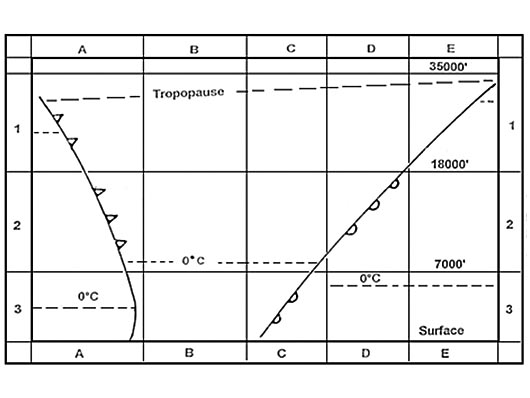
Question 106-6 : How does tas vary in a constant mach climb in the troposphere under isa conditions ?
Tas decreases.
For those questions use the very simple ertm diagram 1039the mach line is vertical because the question states in a constant climb mach ertm for e as r as rectified air speed or cas t as m achmach number = tas local sound speedthe velocity of sound is decreasing as temperature decreases to maintain constant mach as the velocity of sound reduces tas has to reduceTas increases. tas is constant. tas is not related to mach number.
Question 106-7 : The optimum long range cruise altitude for a turbojet aeroplane ?
Increases when the aeroplane mass decreases.
Is always equal to the powerplant ceiling. is independent of the aeroplane mass. is only dependent on the outside air temperature.
Question 106-8 : How does the specific range change when the altitude increases for jet aeroplane flying with the speed for maximum range ?
First increases then decreases.
Decreases. does not change. increases only if there is no wind.
Question 106-9 : At referenceassuming constant ld ratio which of the diagrams provided correctly shows the movement of the 'thrust required curve'mass m1 is higher than mass m2 err a 032 55 ?
C.
The curve is the total drag on the 'thrust required curve' or 'drag or thrust required against airspeed' with less mass you need less lift ==> less lift = less induced draginduced drag will decrease displacing the total drag curve downwards and to the leftthe lowest point on the curve is vmd eas for minimum drag vmd velocity minimum drag decreasesA b d
Question 106-10 : Long range cruise is a flight procedure which gives ?
A specific range which is approximately 99% of maximum specific range and a higher cruise speed.
Question 106-11 : A commercial flight is planned with a turbojet aeroplane to an aerodrome with a landing distance available of 2400 mthe aeroplane mass must be such that on arrival the aeroplane can be landed within ?
1 440 m.
Eu ops 1515 landing dry runways a an operator shall ensure that the landing mass of the aeroplane determined in accordance with eu ops 1475 a for the estimated time of landing at the destination aerodrome and at any alternate aerodrome allows a full stop landing from 50 ft above the threshold 1 for turbo jet powered aeroplanes within 60% of the landing distance available or 2 for turbo propeller powered aeroplanes within 70% of the landing distance available 2400 x 06 = 1440 m 1 250 m. 1 090 m. 1 655 m.
Question 106-12 : At the destination aerodrome the landing distance available is 3000mthe appropriate weather forecast indicates that the runway at the estimated time of arrival will be wetfor a commercial flight the mass of a turbojet aeroplane at landing must be such that the aeroplane can be landed within ?
1565 m.
Eu ops 1515 landing dry runways allows a full stop landing from 50 ft above the threshold 1 for turbo jet powered aeroplanes within 60% of the landing distance available landing wet and contaminated runways a the landing distance available is at least 115% of the required landing distance determined in accordance with eu ops 15153000 m x 06 = 1800 m1800 m 115 = 1565 m2070 m. 1800 m. 2609 m.
Question 106-13 : With zero wind the angle of attack for maximum range for an aeroplane with turbojet engines is ?
Lower than the angle of attack corresponding to maximum endurance.
1100for a jet aeroplane maximum endurance is achieved at a speed corresponding to the maximum ld ratio which is vmd where the gap between power required and power available is greatest at this speed for a conventional aerofoil the angle of attack is about 4°the speed for maximum range occurs at 132 times the speed of minimum drag vmd in level flight as speed goes up the angle of attack goes down angle of attack is less than 4° typically at around 25° example at 10° you are at the maximum range aoaat 16° you are at the maximum endurance aoa 2416Equal to the angle of attack corresponding to maximum endurance. equal to the angle of attack corresponding to zero induced drag. equal to the angle of attack corresponding to maximum lift to drag ratio.
Question 106-14 : Two identical turbojet aeroplane whose specific fuel consumptions are considered to be equal are at holding speed at the same altitudethe mass of the first aircraft is 130 000 kg and its ho y fuel consumption is 4300 kgh the mass of the second aircraft is 115 000 kg and its ho y fuel consumption is ?
Question 106-15 : A jet aeroplane equipped with old engines has a specific fuel consumption of 006 kg per newton of thrust and per hour and in a given flying condition a fuel mileage of 14 kg per nautical milein the same flying conditions the same aeroplane equipped with modern engines with a specific fuel ?
Question 106-16 : The determination of the maximum mass on brake release of a certified turbojet aeroplane with 5° 15° and 25° flaps angles on take off leads to the following values with wind flap angle 5° 15° 25°flltom kg 66 000 69 500 71 500cltom 72 200 69 000 61 800wind correction head wind +120kgkt tail ?
67700 kg 15°.
Cltom climb limited take off massflltom field length limited take off massthe climb limited take off mass is based on still air so the wind correction is only applied to the runway limitationtailwind component is 5 kt correction is 360 x 5 = 1800 kgfield length limited take off mass runway limit for flap 5° = 66000 1800 = 64200 kgrunway limit for flap 15° = 69500 1800 = 67700 kgrunway limit for flap 25° = 71500 1800 = 69700 kgthe climb limited take off mass remain unchangedso maximum take off mass is 67700 kg and flap 15°69000 kg / 15°. 72200 kg / 5°. 69700 kg / 25°.
Question 106-17 : During certification test flights for a turbojet aeroplane the actual measured take off runs from brake release to a point equidistant between the point at which vlof is reached and the point at which the aeroplane is 35 feet above the take off surface are 1747 m all engines operating 1950 m with ?
2009 m.
The certificated value of the take off run is the greater of the all engine distance x 115 or engine out distance all engine distance x 115 = 1747 x 115 = 2009 mengine out distance = 1950 m1950 m. 2096 m. 2243 m.
Question 106-18 : For a twin engine turbojet aeroplane two take off flap settings 5° and 15° are certifiedgiven field length avalaible= 2400 moutside air temperature= 10°cairport pressure altitude= 7000 ftthe maximum allowed take off mass is 2105 ?
56 000 kg.
We'll gonna perform a flap 15° take off 1815you have to be very precise when you are drawing the line otherwise you will always find something closer to 55 000kg than 56 000 kg53 000 kg. 52 000 kg. 70 000 kg.
Question 106-19 : The lowest take off safety speed v2 min is ?
113 vsr for two and three engine turbo propeller and turbojet aeroplanes.
Cs25 v2min in terms of calibrated airspeed may not be less than 1 113 vsr for i two engined and threeengined turbo propeller powered aeroplanes and ii turbojet powered aeroplanes without provisions for obtaining a significant reduction in the one engine inoperative power on stall speed 2 108 vsr for i turbo propeller powered aeroplanes with more than three engines and ii turbojet powered aeroplanes with provisions for obtaining a significant reduction in the one engine inoperative power on stall speed and 3 110 times vmc established under cs 25149vsr reference stall speed1.20 vsr for all aeroplanes. 1.15 vsr for all turbojet and turbo-propeller aeroplanes. 1.20 vsr for all turbo-propeller aeroplanes.
Question 106-20 : Which of the following three speeds of a jet aeroplane are basically identical the speeds for ?
Holding maximum climb angle and minimum glide angle.
Holding speed for a jet is at the vmd speed vmd means velocity minimum drag this is the speed for minimum fuel consumption for a jet aeroplane the maximum climb angle is achieved at a speed corresponding to the maximum clcd ratio which is vmd where the gap between power required and power available is greatest minimum glide angle speed permits to fly the longest ground distance without wind it is achieved at a speed corresponding to the maximum clcd ratio which is vmdMaximum drag, maximum endurance and maximum climb angle. maximum range, minimum drag and minimum glide angle. maximum climb angle, minimum glide angle and maximum range.
Question 106-21 : The lift coefficient decreases during a glide with constant mach number mainly because the ?
Ias increases.
Tas and ias increase during a descent at constant mach number thus we must decrease our angle of attack otherwise the lift will increase lift = 12 rho s v² cl and the descent may be stoppedso it is the increase in tas and ias which lead to decreasing the lift coefficientAircraft mass decreases. tas decreases. glide angle increases.
Question 106-22 : During a descent at constant mach number the margin to low speed buffet will ?
Increase because the lift coefficient decreases.
During a descent at constant mach number your tas increaseswith increasing tas ias is increasing thus from the lift formula the lift coefficient decreasesthe gap between your speed and the stall speed increases the margin to low speed buffet will increase because the lift coefficient decreasesRemain constant, because the mach number remains constant. increase, because the lift coefficient increases. decrease, because the lift coefficient decreases.
Question 106-23 : A jet aeroplane is climbing at a constant ias and maximum climb thrust how will the climb angle the pitch angle change ?
Reduce decrease.
To maintain a constant ias while climbing you have to reduce the climb angle power available is decreasing with an increase of altitude we already are at max climb thrust therefore a reduction of the climb angle is done by reducing the pitch angleReduce / remain constant. remain constant / decrease. remain constant / become larger.
Question 106-24 : A jet aeroplane is flying long range cruise how does the specific range fuel flow change ?
Increase decrease.
The question doesn't compare long range cruise and maximum range cruisespecific range is given as distance covered per unit of fuel as you are flying the aircraft mass decreases for the same long range cruise speed the fuel flow decreasesthus the specific range increases along the flight since for a same distance covered your fuel consumption is decreasedIncrease / increase. decrease / increase. decrease / decrease.
Question 106-25 : During a glide at constant mach number the pitch angle of the aeroplane will ?
Decrease.
During a glide the aircraft is descendingdescent + constant mach number => tas increasesee ertm diagram 1039the mach line is vertical because the question states a glide at constant mach number if tas increase => pitch angle decrease to remain at constant machIncrease. increase at first and decrease later on. remain constant.
Question 106-26 : During a cruise flight of a jet aeroplane at constant flight level and at the maximum range speed the ias the drag will ?
Decrease decrease.
To maintain flight at max range speed which is the tangent to the drag curve and 132 vmd we must reduce speed as mass decreases to maintain 132 vmd the mass reduction as a consequence of fuel burn means less induced drag the total drag curve moves down and left and takes 132 vmd with itIncrease / decrease. increase / increase. decrease / increase.
Question 106-27 : An aeroplane descends from fl 410 to fl 270 at its cruise mach number and from fl 270 to fl 100 at the ias achieved at fl 270assuming idle thrust a clean configuration and ignoring compressibility effects how does the angle of descent change i in the first and ii in the second part of the descent ?
I increases ii remains constant.
Descending at constant mach ias and tas will increasetotal drag is proportional to v² drag will increase while descending and in order to maintain a constant mach number you must increased descent angle at idle thrust at fl270 now we perform descent with a constant ias tas will decrease and density will increase and drag will stay constant our angle of descent will also stay contant(i) increases (ii) decreases. (i) remains constant (ii) decreases. (i) decreases (ii) increases.
Question 106-28 : With a jet aeroplane the maximum climb angle can be flown at approximately ?
The maximum clcd ratio.
1100for a jet aeroplane the maximum climb angle is achieved at a speed corresponding to the maximum clcd ratio which is vmd where the gap between power required and power available is greatest 1.1 vs. the maximum cl/cd² ratio. 1.2 vs.
Question 106-29 : What happens to the drag of a jet aeroplane if during the initial climb after take off constant ias is maintained assume a constant mass ?
The drag remains almost constant.
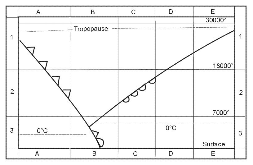
During initial climb if ias is maintained constant tas increases see ertm graph below and density decreasesyou can maintain a constant angle of attack to produce the same lift and if lift does not change the drag remains almost constant 1960the easias line is vertical because the question states constant ias is maintained The drag increases considerably. the drag decreases. the drag increases initially and decreases thereafter.
Question 106-30 : Which of the following sequences of speed for a jet aeroplane is correct from low to high speeds ?
Vs maximum angle climb speed maximum range speed.
Vs, maximum range speed, maximum angle climb speed. maximum endurance speed, maximum range speed, maximum angle of climb speed. maximum endurance speed, long range speed, maximum range speed.
Question 106-31 : If a flight is performed with a higher cost index at a given mass which of the following will occur ?
A higher cruise mach number.
A lower cruise mach number. an increased maximum range. an increased long range performance.
Question 106-32 : For a jet transport aeroplane which of the following is the reason for the use of 'maximum range speed' ?
Minimum specific fuel consumption.
Specific fuel consumption is weight of fuel consumed per unit power per unit timethe reason for the use of 'maximum range speed' is because you want to go the far as possibleusually a commercial airplane fly at 'long range speed' which is 4% faster than 'maximum range speed' you will lose only 1% of the maximum specific range but you will save time and thus you will reduce the whole costs atc fees engines ho y costs leasing costs crew costs if you are looking for the longest flight duration you will fly at minimum fuel flow consumptionMinimum fuel flow. longest flight duration. minimum drag.
Question 106-33 : What happens when an aeroplane climbs at a constant mach number ?
The lift coefficient increases.
Lift = cl x 12 rho v² x scl = lift coefficientrho = density v = tas in ms s = surfacefor a standard commercial aircraft the climb is first carried out at constant ias and after the crossover altitude at constant mach numberif you look at the ertm diagram for a climb at constant ias 1960we can see that tas increases when altitude increasesnow if you look at the ertm diagram for a climb at constant mach number 1039we can see that tas decreases when altitude increasessince rho decreases in both case and tas decreases when we climb at constant mach number to maintain lift we must increase our angle of attack which means an increase in lift coefficient The “1.3g” altitude is exceeded, so mach buffet will start immediately. the tas continues to increase, which may lead to structural problems. ias stays constant so there will be no problems.
Question 106-34 : Which of the following is a reason to operate an aeroplane at 'long range speed' ?
It is efficient to fly slightly faster than with maximum range speed.
In order to achieve speed stability. the aircraft can be operated close to the buffet onset speed. in order to prevent loss of speed stability and tuck-under.
Question 106-35 : If the value of the balanced v1 is found to be lower than vmcg which of the following is correct ?
V1 must be increased to at least the value of vmcg.
Vmcg is the minimum speed at which it is possible to maintain control following the failure of the critical engine during the take off run if the failure occurs before vmcg then the aircraft will go out of control and run off the side of the runway for this reason v1 must never be less than vmcg if pre take off performance calculations reveal that v1 is less than vmcg then v1 must be increased to equal vmcgThe one engine out take-off distance will become greater than the asdr. the vmcg will be lowered to v1. the asdr will become greater than the one engine out take-off distance.
Question 106-36 : Reduced take off thrust should normally not be used when ?
Windshear is reported on the take off path.
It is dark. the runway is dry. the runway is wet.
Question 106-37 : Reduced take off thrust should normally not be used when ?
The runway is contaminated.
It is dark. the runway is wet. obstacles are present close to the end of the runway.
Question 106-38 : The use of reduced take off thrust is permitted only if ?
The actual take off mass tom is lower than the field length limited tom.
A reduced thrust take off is a take off that is accomplished utilizing less thrust than the engines are capable of producing under the existing conditions of temperature and pressure altitudeit is not necessary to use the maximum takeoff thrust when you are not at the maximum takeoff weight performance limited take off mass The take-off distance available is lower than the take-off distance required one engine out at v1. the actual take-off mass (tom) including a margin is greater than the performance limited tom. the actual take-off mass (tom) is greater than the climb limited tom.
Question 106-39 : Which combination of circumstances or conditions would most likely lead to a tyre speed limited take off ?
A high runway elevation and tail wind.
Conditions would most likely lead to a tyre speed limited take off are high tas high groundspeeds high temperatures tailwinds and high pressure altitudesyou need to increase take off speed since the density is reducing to gain your liftA low runway elevation and a cross wind. a high runway elevation and a head wind. a low runway elevation and a head wind.
Question 106-40 : The drift down requirements are based on ?
The obstacle clearance during a descent to the new cruising altitude if an engine has failed.
In a multi engine aircraft losing power from one or more engines may require a descent due to aircraft weight and atmospheric conditions if a descent is required the most fuel efficient method is a driftdownthis would be done by first setting the engines to a prescribed power setting usually set to max continuous thrust mct on the remaining engine s then achieving a computed driftdown airspeed begin a descent to the best altitude for the aircraft on the engines that are remaining 2519the goal is to stay the longest time at high altitude to remain clear of obstacles and to burn the less fuel as possible for having the maximum chances to reach a suitable airportThe actual engine thrust output at the altitude of engine failure. the maximum flight path gradient during the descent. the landing mass limit at the alternate.
Exclusive rights reserved. Reproduction prohibited under penalty of prosecution.