A free Premium account on the FCL.055 website! Read here
Sign up to unlock all our services and 15164 corrected and explained questions.
Question 174-1 : The mean height of the tropical zero degree isotherm is ? [ Practice protocol ]
16000 ft
Question 174-2 : Which of the following statements concerning the airflow during the summer monsoon is correct ?
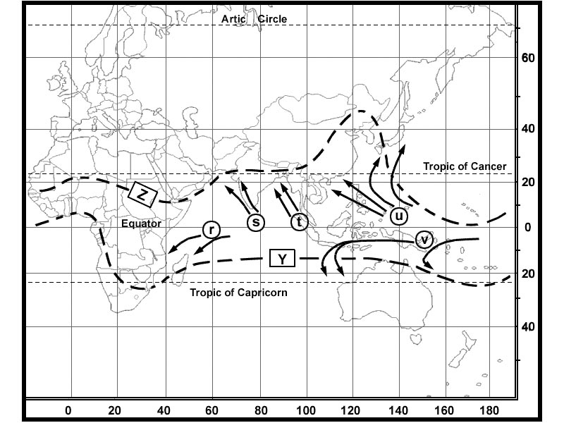
Southwesterly airflow over india.
Northeasterly airflow over india. westerly airflow over japan. easterly airflow over japan.
Question 174-3 : What are the typical weather conditions in a cold air pool in summer ?
Precipitation is predominant.
Generally fine weather, thunderstorms in the afternoon or evening. fine weather with thunderstorms in the morning or forenoon ground fog formation is common.
Question 174-4 : The trade winds on the northern hemisphere blow from ?
North east.
Ecqb01 2013 596North. west. south-west.
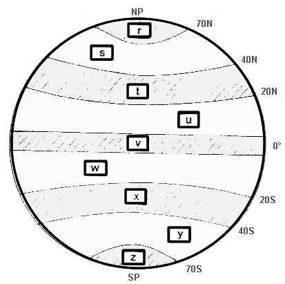
Question 174-5 : Central europe is situated in the zone of ?
Question 174-6 : Which of the following situations will be typical for the intertropical convergence zone ?
Low pressure and instability.
Ecqb01 june 2013Hot, mainly dry climate. high pressure the whole year, accompanied by strong prevailing winds. high pressure the whole year, accompanied by calm winds.
Question 174-7 : With regard to temperature which of the following is correct for the polar climates ?
The mean temperature of all months is below plus 10°c.
Easa 2014the polar climate regions are characterized by a lack of warm summers every month in a polar climate has an average temperature below 10°c regions with polar climate cover more than 20% of the earth the sun shines for long hours in the summer and for many fewer hours in the winter a polar climate results in treeless tundra glaciers or a permanent or semi permanent layer of ice it has cool summers and very cold wintersThe mean temperature of all months is above 0°c%2c but temperatures as high as plus 10°c will never be reached. the mean temperature of all months is below minus 10°c. the mean temperature of the warmest month is 10°c or above, and of the coldest month below minus 3°c.
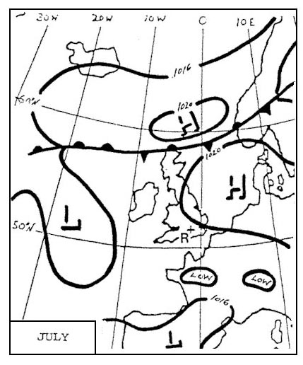
Question 174-8 : What are the typical weather conditions in a westerly situation ?
Very changeable.
596westerlies average latitude are 50°n and 50°sa series of fronts or depressions one after the other is referred to as a westerly wave the weather conditions are very changeableSteady rainfall. fine weather with strong westerly winds. frequent thunderstorms during winter.
Question 174-9 : How is an easterly wave identifiable on a surface weather chart ?
As a weak trough.
Easa 2014easterly waves are 'long waves' that occur within the trade wind belt start over north western africa and propagate toward the west in the lower tropospheric tradewind flow across the atlantic oceanapproximate location amplitude and wavelength of easterly waves 495at first an easterly wave has a small amplitude and produces mild rain showers powerful thunderstorms and the force of high altitude winds amplify the wave when atmospheric conditions are favourable several severe thunderstorms begin to form and eventually a tropical storm may develop 638thunderstorms are most likely to develop on the east side of the waveAs a well developed depression. as a ridge. as a secondary depression.
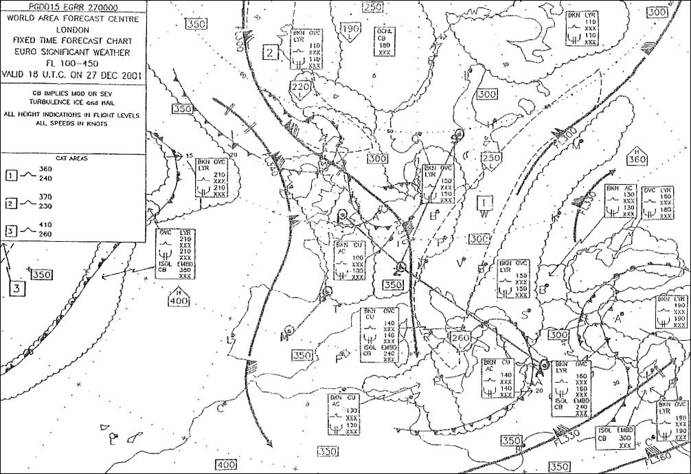
Question 174-10 : The main icing zone in the itcz is located between ?
Fl 160 fl 260.
Fl 300 - fl 400. fl 250 - fl 350. fl 50 - fl 150.
Question 174-11 : The mean top of a thunderstorm cluster in the tropics is up to ?
50000 ft.
60000 ft. 30000 ft. 40000 ft.
Question 174-12 : What is the reason for seasonal changes in climate ?
Because the earth's spin axis is inclined to the plane of its orbit round the sun.
Because the earth's orbital speed round the sun varies according to the time of the year. because of the difference between the tropical year and the calendar year. because the distance between the earth and the sun varies over the year.
Question 174-13 : In the central part of the atlantic ocean between 10°s and 20°s the prevailing winds are ?
Se trade winds.
Take care this question exists with 10°n and 20°n answer is 'ne trade winds' 584the question asks for the prevailing winds only between 10°n and 20°n above the atlantic ocean 2537Ne monsoon in winter and sw monsoon in summer. ne trade winds. sw winds throughout the whole year.
Question 174-14 : The intertropical convergence zone ?
Is characterized by different wind directions on both sides of the zone.
Nearly always coincides with the geographical equator. is always characterized by cb clouds with high tops. forms the boundary between tropical and equatorial air.
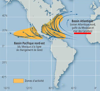
Question 174-15 : In the indian ocean the name given to the violent tropical storms that can be encountered is ?
Tropical cyclone.
Cyclone from greek 'kuklos' means 'circle' is a generic term for all tropical revolving storms according to the geographical location the terminology differs cylcone in the south western and northern pacific ocean and the south western indian oceanhurricane as derived from huracàn a taino and carib god or hunraken the mayan storm in the northern atlantic ocean and the north eastern and south western pacific ocean east of 160e typhoon from chinese t'ai fung located in in the north western pacific ocean 603Typhoon. hurricane. tornado.
Question 174-16 : The average speed of a tropical cyclone is ?
Less than 60 kt.
From 60 kt to 140 kt. from 140 kt to 180 kt. from 180 kt to 250 kt.
Question 174-17 : What is the effect of a strong low level inversion ?
It promotes vertical wind shear.
646It promotes extensive vertical movement of air. it prevents vertical wind shear. it results in good visual conditions near the surface.
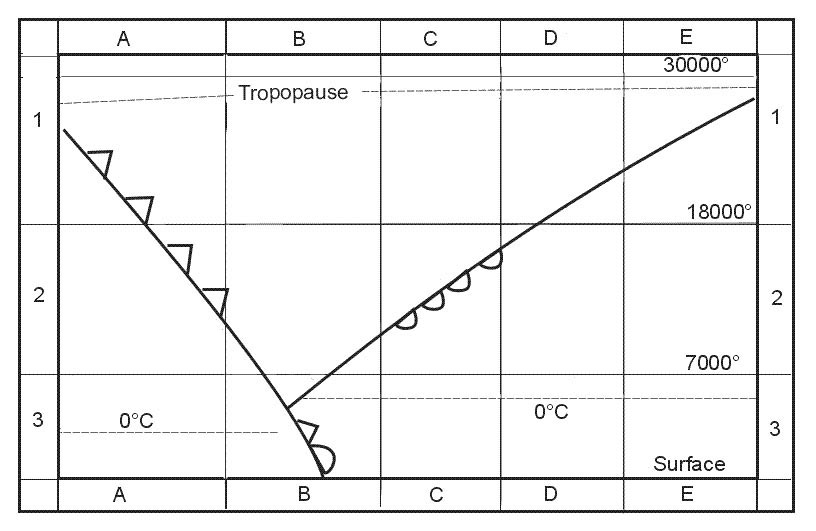
Question 174-18 : You are flying with an outside air temperature of 12°c and a tas of 250 kt at fl 150 through 8 oktas ns what type and degree of icing is most probable ?
In clouds pushed up against the mountains moderate to severe mixed ice.
In clouds pushed up against the mountains the lifting action orographic will mean that larger super cooled water droplets are present which will increase the severity of the icing to moderate to severeat 12°c this is a temperature where there will be some clear ice and some rime iceIn clouds pushed up against the mountains, moderate to severe clear ice. over flat terrain, away from fronts, moderate to severe mixed ice. over flat terrain, moderate hoar frost.
Question 174-19 : You intend to carry out a vfr flight over the alps on a fine and hot summer day what is the best time of day to conduct this flight ?
Morning.
The minimum temperature is reached not long after sunrise and on a fine and hot summer day convection currents will increase wind speed and turbulence along the day furthermore in the evening over the alps in summer risks of thunderstorm due to orographic lifting and instability is highcalmest conditions will be in the morningMid-day. afternoon. early evening.
Question 174-20 : At what time of the year are tornadoes most likely to occur in north america ?
Spring summer.
Fonsvanheertum tornadoes in n america are hurricanes no my book says that they appear from june until nov so shouldn't the answer summer autumn be correct hurricanes are tropical revolving storms 493tornadoes are large funnel cloud with water spouts associated with very large cumulonimbus clouds these cb clouds need maximum convective lifting and this will be there in springsummerSummer, autumn. winter. autumn, winter.
Question 174-21 : In central europe when is the greatest likelihood for thunderstorms due to warm updrafts ?
Mid afternoon.
Around midnight. early morning. late morning.
Question 174-22 : During which stage of thunderstorm development are rotor winds characterized by roll clouds most likely to occur ?
Mature stage.
494Cumulus stage. dissipating stage. cumulus stage and mature stage.
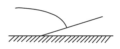
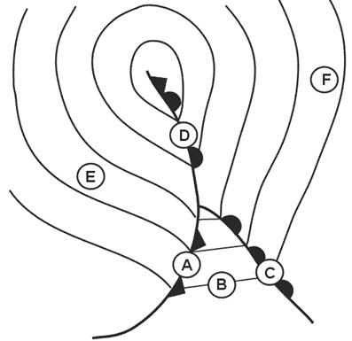
Question 174-23 : Where is a squall line to be expected ?
In front of an active cold front.
When many individual thunderstorms organize into a nearly continuous line a squall line is born they can be more than 80 nm long and often form 40 to 130 nm ahead of advancing cold fronts racing along squall line thunderstorms blast the ground with torrents of rain and hail driven by winds gusting higher than 50 ktBehind a cold front. in front of a cold front occlusion at higher levels. at the surface position of a warm front.
Question 174-24 : What are squall lines ?
Bands of intensive thunderstorms.
When many individual thunderstorms organize into a nearly continuous line a squall line is born they can be more than 80 nm long and often form 40 to 130 nm ahead of advancing cold fronts racing along squall line thunderstorms blast the ground with torrents of rain and hail driven by winds gusting higher than 50 ktUnusual intensive cold fronts. the surface weather associated with upper air troughs. the paths of tropical revolving storms.
Question 174-25 : In which of these temperature bands is ice most likely to form on the aircraft's surface ?
0°c to 10°c.
+10°c to 0°c -20°c to -35°c -35°c to -50°c
Question 174-26 : Which of the following statements is true regarding moderate to severe airframe icing ?
It is likely to occur in nimbostratus cloud.
Ns nimbostratus produces heavy rain if the rain falls through a cold air mass below the freezing level moderate to severe airframe icing can occurin clear air you can only have light airframe icing not moderate or severe on the top of a cumulonimbus temperature is too coldit will not always occurs in altostratus cloud it dépends on the air mass temperatureIt will occur in clear-sky conditions. it may occur in the uppermost levels of a cumulonimbus capillatus formation. it always occurs in altostratus cloud.
Question 174-27 : Which of the following statements is true regarding moderate to severe airframe icing ?
It will not occur in clear sky conditions.
Ns nimbostratus produces heavy rain if the rain falls through a cold air mass below the freezing level moderate to severe airframe icing is likely to occurit will not always occurs in altostratus cloud it dépends on the air mass temperaturein clear air you can only have light airframe icing not moderate or severe on the top of a cumulonimbus temperature is too coldIt always occurs in altostratus cloud. it is unlikely to occur in nimbostratus cloud. it will occur in the anvil part of the cumulonimbus cloud.
Question 174-28 : Which of the following conditions is most likely to cause airframe icing ?
+fzra.
Gr shsn pe
Question 174-29 : Rime ice forms through the freezing onto aircraft surfaces of ?
Small supercooled water drops.
clear ice forms on an aircraft by the freezing of large supercooled water drops rime ice forms through the freezing onto aircraft surfaces of small supercooled water dropsLarge supercooled water drops. water vapour. snow.
Question 174-30 : How does a pilot react to heavy freezing rain at 2000 ftagl when he is unable to deice nor land ?
He turns back before the aircraft loses manoeuvrability.
Freezing rain is associated with warm fronts and warm occlusions in a warm front the freezing level is lower than behind in the warm sector and the slope means that freezing rain will be falling on anything underneathat 2000 ft above ground level descending could be dangerous and you are not sure to reach enough warmer air to deice 505remain at the same altitude will give a dangerous build up of ice on the airframeascend into cold air means you will not lose the ice and climbing into frontal cloud will give more icethe best solution is to turn back to get out of this freezing rain quicklyHe descends to the warm air layer below. he ascends to the cold air layer above. he continues to fly at the same altitude.
Question 174-31 : In which of the following conditions is moderate to severe airframe icing most likely to be encountered ?
In nimbostratus cloud.
Airframe icing will not happen in cirrus cloud composed of ice crystals or if the temperature is above 0ºc ns nimbostratus produces heavy rain if the rain falls through a cold air mass below the freezing level moderate to severe airframe icing can occurin clear air you can only have light icingBelow the freezing level in clear air. in clear air above the freezing level. within cloud of any type.
Question 174-32 : What flying conditions are normally encountered when flying in cirrus clouds ?
Average horizontal visibility more than 1000 m nil icing.
Average horizontal visibility less than 500 m, nil icing. average horizontal visibility less than 500 m, light to moderate icing. average horizontal visibility more than 1000 m, light to moderate rime ice.
Question 174-33 : How does freezing rain develop ?
Rain falls through a layer where temperatures are below 0°c.
505freezing rain is encountered ahead of a warm front in winter and in summer and sometimes behind a cold front Snow falls through a layer where temperatures are above 0°c. through melting of snow grains. through melting of ice crystals.
Question 174-34 : What weather conditions in the region of the alps would you expect with foehn from south ?
Clouds on the southern sides of passes in the alps.
520the southerly wind will give a foehn 'from south' clouds on the southern sideHeavy clear air turbulence on the southern side of the alps. strong north winds on the southern side of the alps. heavy airframe icing conditions on the northern side of the alps.
Question 174-35 : Under which conditions would you expect the heaviest clear ice accretion to occur in a cb ?
Between 2°c and 15°c.
Arizona there is another question that states that as water droplets are bigger in cumulus clouds clear ice would appear between 0 to 23 degreesso why isnt answer 'between 20 and 30' correct the question you are talking about is 'ice accretion to the airframe is likely to be most hazardous at temperatures between 0°c and 23°c in large cu'explanation for this question the most severe icing is clear ice clear ice will form in stratus between 0ºc and 7ºc but in cumulus the larger droplet size will give clear ice at temperature between 0ºc and 23ºcsince the clear ice accretion can occur at temperatures warmer than 20°c the answer between 2°c and 15°c is the most correct oneBetween -20°c and -30°c. close to the freezing level. between -30°c and -40°c.
Question 174-36 : Clear ice forms on an aircraft by the freezing of ?
Large supercooled water drops.
clear ice forms on an aircraft by the freezing of large supercooled water drops rime ice forms through the freezing onto aircraft surfaces of small supercooled water dropsWater vapour. small supercooled water drops. snow.
Question 174-37 : What weather conditions would you expect at a squall line ?
Thunderstorms.
When many individual thunderstorms organize into a nearly continuous line a squall line is born they can be more than 80 nm long and often form 40 to 130 nm ahead of advancing cold fronts racing along squall line thunderstorms blast the ground with torrents of rain and hail driven by winds gusting higher than 50 ktContinuous heavy rain. fog. strong whirlwinds reaching up to higher levels.
Question 174-38 : What is the approximate maximum diameter of a the area affected by damaging winds at the surface caused by a microburst ?
4 km.
A microburstdownburst is a localized area of damaging winds caused by air rapidly flowing down and out of a thunderstorm a microburst occurs when cold air high in a thunderstorm descends and accelerates as the stream of cold air reaches the ground it spreads out and can accelerate even further400 m. 20 km. 50 km.
Question 174-39 : In general the visibility during rainfall compared to during drizzle is ?
Greater.
521the two forms of liquid precipitation drizzle and rain are classified in a number of ways depending on the size of the drops the visibility associated with the precipitation and the rate at which it fallsdrizzle which is defined as drops with diameters less than 002 inches falling close together usually falls from stratus clouds the relatively thin stratus clouds have slow upward moving air currents in these conditions cloud droplets have little time to grow before they become too heavy for the air currents to support the drops fall to the ground appearing to float in air currents as seen in the graphic above the intensity of drizzle is based on the visibility at the time the precipitation is fallingrain which is composed of widely separated drops with diameters usually greater than 002 inches generally falls from towering cumulus clouds the cumulus clouds with fast upward moving air currents allow cloud droplets to combine and grow raindrops can reach sizes up to 025 inches before falling to the ground the intensity of rain is based on the amount that falls in one hour the intensity can also be estimated visuallyThe same. less. in rain - below 1 km, in drizzle - more than 2 km.
Question 174-40 : Which of the following symbols represents a squall line 264 ?
Symbol 1.
Icao annex 3 meteorological service for international air navigation 547Symbol 2) symbol 3) symbol 4)
Exclusive rights reserved. Reproduction prohibited under penalty of prosecution.