A free Premium account on the FCL.055 website! Read here
Sign up to unlock all our services and 15164 corrected and explained questions.
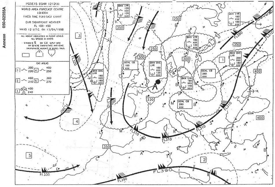
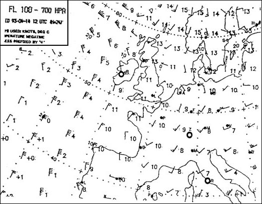
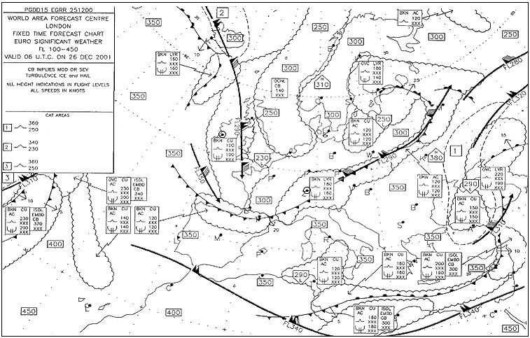
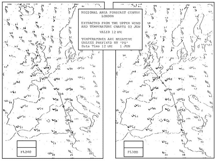
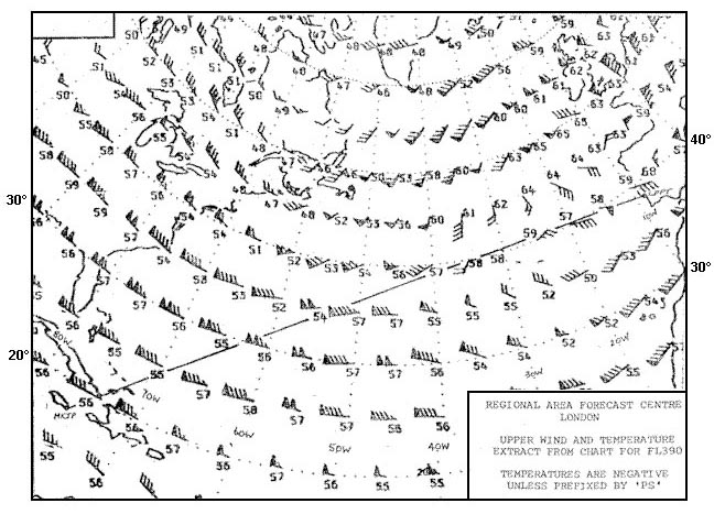
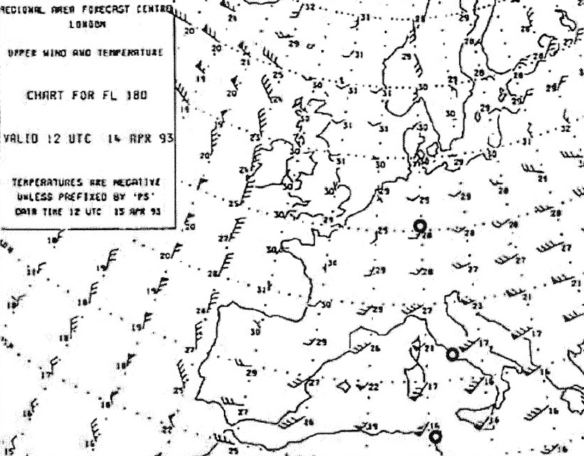
Question 175-1 : Over madrid what intensity of turbulence and icing is forecast at fl 200 267 ? [ Practice protocol ]
Moderate turbulence moderate icing
Question 175-2 : You are flying from munich to amsterdam which of the following flight levels would you choose in order to avoid turbulence and icing 272 ?
Fl 260.
There is icing from below fl100 xxx up to fl180 turbulence up to fl200 and cat between fl280 and fl390 you must choose a flight level from fl210 to fl270Fl 320. fl 180. fl 140.
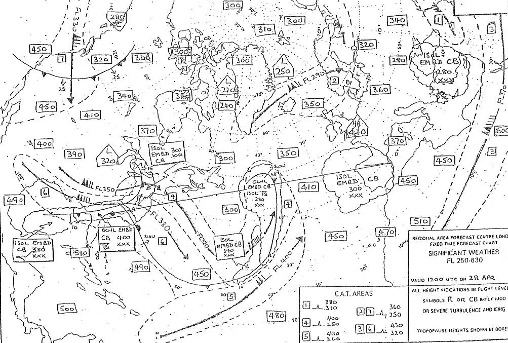
Question 175-3 : In what height range and at what intensity could you encounter turbulence in cat area n°2 273 ?
From fl 220 to fl 400 moderate.
524From fl 240 to fl 370, light. from below fl 130 to fl 270, light. from fl 250 to fl 320, moderate.
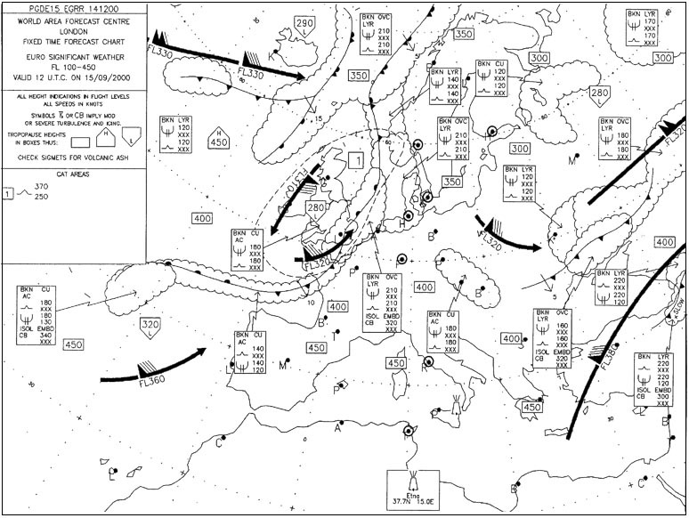
Question 175-4 : At which position is the development of thunderstorms most likely and what is the maximum height of the cb clouds at 00 utc 275 ?
Position b fl 270.
At position b you can read in the weather bubble with the lightening arrow isol embd cb from below chart level up to fl 270isolated embedded cumulonimbus means probably thunderstorms and the maximum height of the cb clouds is forecast up to fl270Position a, fl 200. position c, fl 200. position d, fl 290.
Question 175-5 : Flight lisbon to bordeaux eta 1800 utc at eta bordeaux what is the lowest quoted visibility forecast taf lfbd 281400z 281524 26015kt 9999 shra bkn020 tempo 1620 26020g30kt 8000 +shra bkn015cb prob30 tsra = ?
8 km.
8 nm 10 nm 10 or more km
Question 175-6 : The lowest visibility forecast at eta zurich 1430 utc is lszh 261019 20018g30kt 9999 ra sct050 bkn080 tempo 23012kt 6000 dz bkn015 bkn030 becmg 1518 23020g35kt 4000 ra ovc010= ?
6 km.
The lowest visibility forecast will generally be more than 10 km but it could go down to 6 km temporarily between 1000z to 1900z lszh 26 1019 20018g30kt 9999 ra sct050 bkn080 tempo 23012kt 6000 dz bkn015 bkn030 becmg 1518 23020g35kt 4000 ra ovc010=after 1500z the visibility will reduce to 4000 m6 nm. 4 km. 10 km.
Question 175-7 : A microburst phenomenon can arise in the ?
Downdraught of a cumulonimbus at the mature stage.
A microburstdownburst is a localized area of damaging winds caused by air rapidly flowing down and out of a thunderstorm a microburst occurs when cold air high in a thunderstorm descends and accelerates the mature stage as the stream of cold air reaches the ground it spreads out and can accelerate even furtherUpdraught of a cumulonimbus at the mature stage. downdraught of a cumulonimbus at the formation stage. updraught of a cumulonimbus at the growth stage.
Question 175-8 : All pilots encountering clear air turbulence are requested to report it you experience cat which causes passengers and crew to feel definite strain against their seat belt or shoulders straps unsecured objects are dislodged food service and walking are difficultthis should be reported as ?
Moderate.
Light. severe. extreme.
Question 175-9 : In the weather briefing room during the pre flight phase of a passenger flight from zurich to rome you examine the following weather reports of pressing importance at the time einn shannon 2808 sigmet 2 valid 08001100 loc sev turb fcst einn fir blw fl 050 south of 53n wkn =limm milano 2809 sigmet 2 ?
Because of the expected turbulence you select a flight level below fl 250.
Information regarding london and shannon are irrelevant in this case since milano lies more or less on the route zurich rome we are only interested in information included in sigmet for milano which clearly states that moderate to severe clear air turbulence is present from fl250 to fl430 hence flight below fl250 would be desirableOwing to these reports and taking into account the presence of heavy thunderstorms at planned fl 310 you select a higher flight level (fl 370). you cancel the flight since the expected dangerous weather conditions along the route would demand too much of the passengers. you show no further interest in these reports, since they do not concern the route to be flown.
Question 175-10 : Isolated thunderstorms of a local nature are generally caused by ?
Thermal triggering.
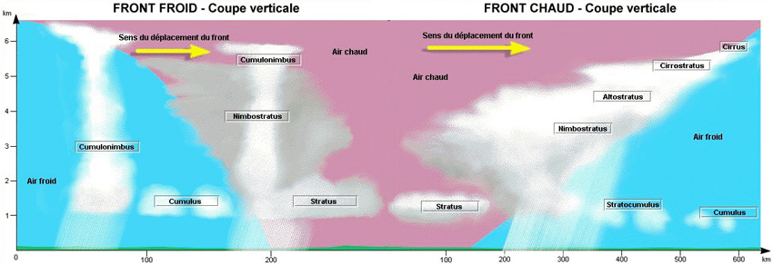
Thermal triggering depends on relatively light winds that allow high surface temperature to develop during summer you can expect local isolated thunderstorms arising from thermal triggering mostly in the mid afternoonFrontal lifting (warm front). frontal lifting (cold front). frontal occlusion.
Question 175-11 : A zone of strong convection currents is encountered during a flight in spite of moderate gust you decide to continue the flight what are your precautionary measures ?
Decrease the speed try to climb above the zone of convective currents if aircraft performance parameters allow.
By decreasing speed you will reduce the risk to encounter some buffeting with gusts the airflow speed on the wing may locally reach mach 1 Increase the speed / try to climb above the zone of convective currents if aircraft performance parameters allow. decrease the speed / try to descend below the zone of convective currents. increase the speed / try to descend below the zone of convective currents.
Question 175-12 : How long does a typical microburst last ?
1 to 5 minutes.
A microburstdownburst is a localized area of damaging winds caused by air rapidly flowing down and out of a thunderstorm a microburst occurs when cold air high in a thunderstorm descends and accelerates the mature stage as the stream of cold air reaches the ground it spreads out and can accelerate even furtherLess than 1 minute. 1 to 2 hours. about 30 minutes.
Question 175-13 : What is normally the most effective measure to reduce or avoid cat effects ?
Change of flight level.
Change of course. increase of speed. decrease of speed.
Question 175-14 : On the approach the surface temperature is given as 5°c the freezing level is at 3000 ftagl at 4000 ftagl there is a solid cloud layer from which rain is fallingaccording to the weather briefing the clouds are due to an inversion caused by warm air sliding up and over an inclined frontwould you ?
Yes between ground level and 3000 ftagl.
Yes, but only between 3000 and 4000 ft/agl. no, flights clear of cloud experience no icing. no, absolutely no icing will occur.
Question 175-15 : Which of the following conditions are most favourable to the formation of mountain waves ?
Stable air at mountain top altitude and a wind at least 20 knots blowing across the mountain ridge.
Standing waves = orographic waves = mountain waves 433in addition to a stable layer of air over a substantial mountain range the conditions most favourable to the development of standing waves are wind speed excess of 20 kt at the surface and increasing with height wind direction perpendicular to the general direction of the rangeUnstable air at mountain top altitude and a wind at least 20 knots blowing across the mountain ridge. either stable or unstable air at mountain top and a wind of at least 30 knots blowing parallel to the mountain ridge. moist unstable air at mountain top and wind of less than 5 knots blowing across the mountain ridge.
Question 175-16 : An aircraft is approaching a cold front from the warm air mass side at fl 270 and experiencing moderate to severe turbulence a jet stream is forecast to be at fl 310 the shortest way to get out of this turbulence is by ?
Descending.
The average width of a jetstream is about 300 km and its thickness is about 12000 ft so you can experience its effects 6000 ft above and below the core the significant weather chart gives the height of the core if the core is given as fl310 then you can experience it up to fl370 and down to fl250 if you are flying at fl270 the quickest way out of it is downClimbing. turn right. maintain fl 270.
Question 175-17 : The jetstream and associated clear air turbulence can sometimes be visually identified in flight by ?
Long streaks of cirrus clouds.
Cirrus clouds are stretched by the flow of the jetstreamDust or haze at high level. a constant outside air temperature. a high-pressure centre at high level.
Question 175-18 : In addition to a lifting action what are two other requirements necessary for thunderstorm formation ?
Unstable conditions and high moisture content.
Stable conditions and high moisture content stable conditions and low atmospheric pressure unstable conditions and high atmospheric pressure
Question 175-19 : If you have to fly through a warm front when freezing level is at 10000 feet in the warm air and at 2000 feet in the cold air at which altitude is the probability of freezing rain the lowest ?
12000 feet.
Freezing rain can be encounter anywhere between 2000 ft and 10000 ft9000 feet. 5000 feet. 3000 feet.
Question 175-20 : From the following taf you can assume that visibility at 2055z in birmingham egbb will be egbb 261812 28015g25kt 9999 sct025 tempo 1822 29018g35kt 5000 shrasn bkn010cb prob30 tempo 1821 1500 tsgr bkn008cb becmg 2124 26010kt ?
Not less than 15 km but could be in excess of 10 km.
The tempo group is used for any conditions in wind visibility weather or sky condition which are expected to last for generally less than an hour at a time occasional and are expected to occur during less than half the time period thus visibility at 20h55 in birmingham will be not less than 15 km between 18h00 and 22h00 it could temporarily deteriorate to 5 km and between 18h00 and 21h00 there is a 30% possibility that it could temporarily deteriorate to 15 km visibility could also be in excess of 10 km 9999 more than half the time period A maximum 5 km. a minimum of 1,5 km and a maximum of 5 km. more than 10 km.
Question 175-21 : The presence of ice pellets at the surface is evidence that ?
Freezing rain occurs at a higher altitude.
A cold front has passed there are thunderstorms in the area a warm front has passed
Question 175-22 : Continuous updraughts occur in a thunderstorm during the ?
Initial stage.
Mature stage. dissipating stage. period in which precipitation is falling.
Question 175-23 : The most dangerous form of airframe icing is ?
Clear ice.
Hoar frost. dry ice. rime ice.
Question 175-24 : The degree of clear air turbulence experienced by an aircraft is proportional to the ?
Intensity of vertical and horizontal wind shear.
Height of the aircraft stability of the air intensity of the solar radiation
Question 175-25 : At what degree of icing should icao's change of course andor altitude desirable recommendation be followed ?
Moderate.
Light. severe. extreme.
Question 175-26 : What degree of aircraft icing is determined by the following icao description conditions in which immediate change of heading andor altitude is considered essential ?
Severe.
Light. moderate. violent.
Question 175-27 : At what degree of icing can icao's no change of course and altitude necessary recommendation be followed ?
Light.
Moderate. severe. extreme.
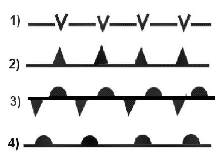
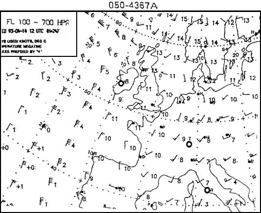
Question 175-28 : On which of the following routes can you expect icing to occur on the basis of the chart 307 ?
Hamburg oslo.
552all of the other routes are out of potential icing areassymbols for moderate and severe aircraft icing 571Rome - frankfurt tunis - rome copenhagen - helsinki
Question 175-29 : If you are flying from zurich to london at fl 240 what conditions can you expect at cruising altitude 309 ?
Moderate or severe turbulence and icing.
554isol embd cb from below fl100 up to fl320 = moderate or severe turbulence and icingFlight largely in cloud, no turbulence. prolonged severe turbulence and icing throughout the flight. cat for the first half of the flight.
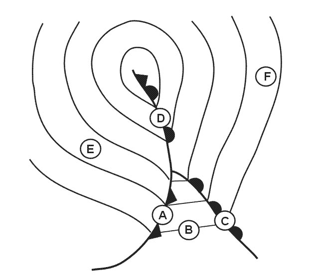
Question 175-30 : Judging by the chart on which of these routes can you expect to encounter moderate cat at fl 300 310 ?
Zurich athens.
On the route from zurich to athens you will fly through the cat area n°1 moderate cat between fl240 fl360 three cat areas can be seen on the chart they are defined by dash lines with the relevant number in the middle of the affected areacat clear air turbulenceLondon - zurich zurich - stockholm madrid - bordeaux
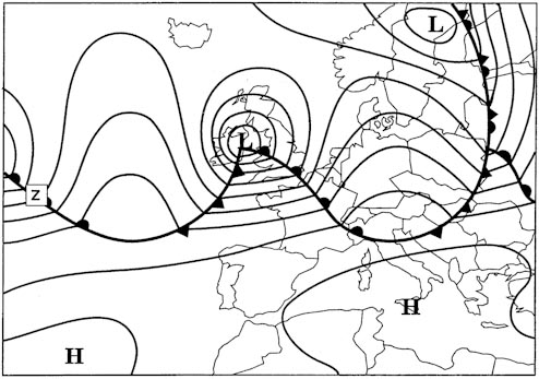
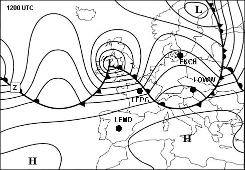
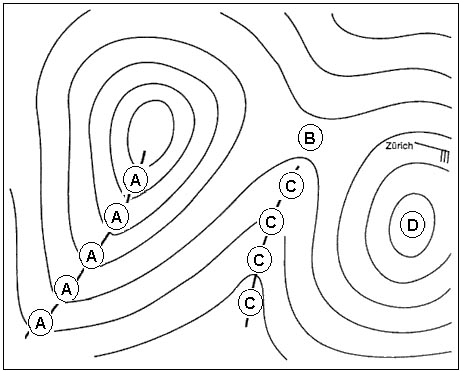
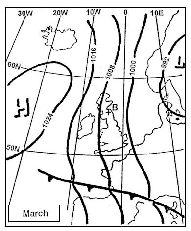
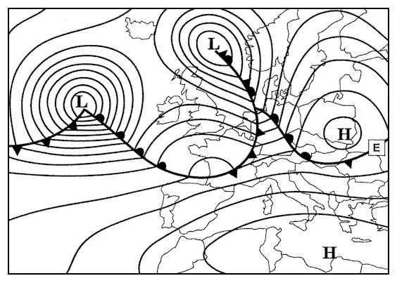
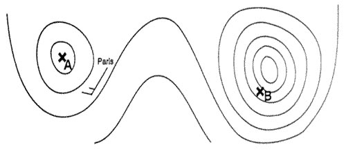
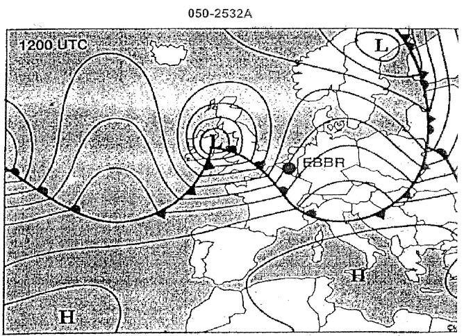
Question 175-31 : Which of these statements is true 312 ?
Scattered thunderstorms can be expected over france.
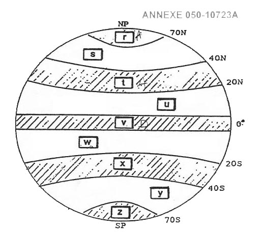
The front over london is moving north the arrow shows a speed of 5 kmh we do not have information about the freezing level over madridturbulence over madrid is from fl170 to fl400 cat area n°1 scattered thunderstorms can be expected over france isol cbTurbulence is likely to be encountered at fl 410 over madrid. freezing level above madrid is higher than fl 120. the front to the north of london is moving south.
Question 175-32 : On which of these routes would you not need to worry about icing at fl 170 313 ?
London stockholm.
556zurich athens isol embd cb 330 xxx isolated embedded cumulonimbus from below fl100 up to fl330 = moderate or severe turbulence and icingparis lisbon and madrid vienna isol embd cb 340 xxx isolated embedded cumulonimbus from below fl100 up to fl340 = moderate or severe turbulence and icing close to lisbonfurthermore both routes cross two warm fronts and icing area one up to fl180 the other up to fl200london stockholm icing and turbulence only go up to fl120Madrid - vienna paris - lisbon zurich - athens
Question 175-33 : You have been flying for some time in dense layered cloud the outside air temperature is 25°c which of the following statements is true ?
Severe airframe icing is unlikely under these conditions.
Severe icing would be encountered in layered cloud between 0°c and 10°c but at 25°c only light or moderate icing would be experiencedSevere airframe icing is quite likely under these conditions. if you do not have weather radar on board there is no need to worry, as cb is unlikely to form in such cloud. in a dense layered cloud icing is unlikely also at an outside air temperature of -5°c.
Question 175-34 : Thunderstorms in exceptional circumstances can occur in a warm front if ?
The warm air is unstable.
Lifting action warm air unstable conditions and high moisture content are the necessary requirements for thunderstorm formationThe cold air is unstable. the cold air is stable. the warm air is stable.
Question 175-35 : Low level wind shear is likely to be greatest ?
At the top of a marked surface based inversion.
Warm air moving horizontally above cold air can produce turbulence at the point where they join as would be typical with an inversion at around 2000 4000ft with a windspeed of 25 kt or more 447At the condensation level when there is no night radiation. at the condensation level when there is strong surface friction. at the top of the friction layer.
Question 175-36 : In which of the following situations is an aircraft most susceptible to icing ?
Level flight below a rain producing cloud when oat is below zero degrees c.
Flying in dense cirrus clouds. level flight in snowfall below a nimbostratus layer. flying in heavy drizzle.
Question 175-37 : A winter day in northern europe with a thick layer of stratocumulus clouds and temperature close to zero degrees c at ground level you can expect ?
A high probability for icing in clouds severe icing may occur in the upper part due to accumulation of large droplets.
Decreasing visibility due to snowfall below cloud base, but only light icing in clouds. reduced visibility and light icing in clouds turbulence due to a strong inversion, but no icing because clouds consist of ice crystals
Question 175-38 : Which one of the following statements concerning the formation of aircraft icing is most correct ?
A cloud consisting of both supercooled water droplets and ice crystals produces aircraft icing.
Greatest risk of icing conditions is experienced in cirrus clouds. risk for icing increases when cloud temperature decreases well below minus 12 degrees c. probability of icing increases when dry snow starts to fall from a cloud.
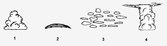
Question 175-39 : The presence of altocumulus lenticularis is an indication of the ?
Presence of mountain waves.
Risk of orographic thunderstorms development of thermal lows presence of valley winds
Question 175-40 : Low level vertical wind shear can be expected during the night ?
In association with radiation inversions.
The ground will remains hot at night the heating will increase radiation inversions strong ground inversions by radiation radiation surface inversions are accompanied with wind shear and turbulenceIn unstable atmospheres and early morning only in winter and early morning only in summer
Exclusive rights reserved. Reproduction prohibited under penalty of prosecution.