A free Premium account on the FCL.055 website! Read here
Sign up to unlock all our services and 15164 corrected and explained questions.
Question 181-1 : Which of the following weather reports could be in accordance with the regulations abbreviated to 'cavok' ? [ Question security ]
15003kt 9999 bkn100 1711 q1024 nosig =
Question 181-2 : Which of the following statements is an interpretation of the metar 25020g38kt 1200 +tsgr bkn006 bkn015cb 2318 q1016 becmg nsw = ?
Gusts of 38 knots thunderstorm with heavy hail dew point 18°c.
Mean wind speed 20-38 knots, visibility 1200 metres, temperature 23°c. broken, cloud base 600 feet and 1500 feet, temperature 18°c. wind 250°, thunderstorm with moderate hail, qnh 1016 hpa.
Question 181-3 : Which of the following statements is an interpretation of the sigmet lsas sigmet 2 valid 030700031100 lszh switzerland firuir mod to sev cat fcst n of alps btn fl 260380 stnr intsf= ?
Moderate to severe clear air turbulence to be expected north of the alps intensity increasing danger zone between fl 260 and fl 380.
Zone of moderate to severe turbulence moving towards the area north of the alps. intensity increasing. pilots advised to cross this area above fl 260. severe turbulence observed below fl 260 north of the alps. pilots advised to cross this area above fl 380. moderate to severe clear air turbulence of constant intensity to be expected north of the alps.
Question 181-4 : Which of the following statements is an interpretation of the sigmet lggg sigmet 3 valid 121420121820 lgat athinai fir embd ts obs and fcst in w part mov e nc = ?
Thunderstorms must be expected in the western part of the athens fir the thunderstorm zone is moving east intensity is constant.
Thunderstorms have formed in the eastern part of the athens fir and are slowly moving west athens airport is closed due to thunderstorms. the thunderstorm zone should be east of athens by 1820 utc the thunderstorms in the athens fir are increasing in intensity, but are stationary above the western part of the athens fir
Question 181-5 : Compare the following taf and volmet reports for nice taf 240600z 240716 vrb02kt cavok =0920z 13012kt 8000 sct040cb bkn100 2018 q1015 tempo ts =what can be concluded from the differences between the two reports ?
That the weather at nice is clearly more volatile than the taf could have predicted earlier in the morning.
Volmet is a defined abbreviation 'meteorological information for aircraft in flight' and the origin is from the french 'vol' flight and 'met' as an abbreviation for meteorology volmet is a broadcast or data link service of meteorological information for aircraft in flight and is provided for in annex 3a volmet is updated along the day a 24h taf is notthis explains the difference between the forecasted and actual weather at 0920 utcThat the weather conditions at 0920 were actually predicted in the taf. that the weather in nice after 0920 is also likely to be as predicted in the taf. that the volmet speaker has got his locations mixed up, because there is no way the latest volmet report could be so different from the taf.
Question 181-6 : Runway visual range rvr is ?
Usually better than visibility.
Rvr is reported when visibility is less than 1500 mthe methods for measuring rvr and prevailing visibility are quite different rvr is measured in a specific direction usually using transmissiometers while the prevailing visibility will be the average and if less than 1500 m the minimum value in a specific direction this means that there can be no direct comparison and rvr is likely to be the same as or greater than the lowest reported value of prevailing visibilityReported when visibility is less than 2000 m. reported in airmet and metar. measured with ceilometers alongside the runway.
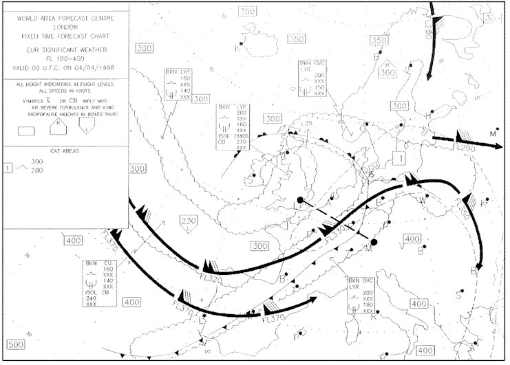
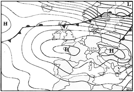
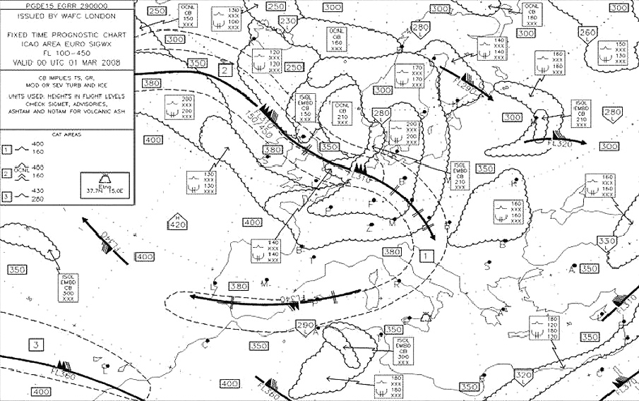
Question 181-7 : What information is given on a significant weather chart ?
The significant weather forecast for the time given on the chart.
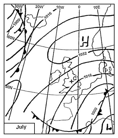
Significant weather charts are published every six hours and predict what the weather situation is for a given time the 09 00z chart would be prepared several hours in advance probably very early in the morning it would indicate for instance the position of a cold front at 09 00z and show its direction and speed of movement with this information you could work out the estimated position of the front at any time between 06 00z and 12 00z so whilst we use it for flights between 06 00z and 12 00z it only shows the weather situation at 09 00zThe significant weather that is observed at the time given on the chart the significant weather in a period 3 hours before and 3 hours after the time given on the chart the significant weather forecast for a period 6 hours after the time given on the chart
Question 181-8 : A pilot is warned of severe icing at certain flight levels by information supplied in ?
Swc and sigmet.
Significant weather chart swc and sigmet warned a pilot of severe icing at certain flight levels significant weather chart uses symbols for moderate and severe aircraft icing 571 sigmet or significant meteorological information is a weather advisory that contains meteorological information concerning the safety of all aircraftthe following are examples of weather phenomena that may be described in a sigmet thunderstorms cyclones tropical revolving storms severe turbulence severe icing severe mountain waves dust or sand storms volcanic ashTaf and metar. metar and sigmet. taf and sigmet.
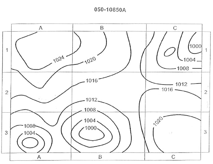
Question 181-9 : An isohypse of the 500 hpa pressure surface is labelled with the number 552 this means that for all points on the isohypse the ?
Topography is 552 decameters above msl.
Topography refers to the shape of any surface here the surface is a pressure level of 500 hpaPressure is 552 hpa. topography is 552 meters above msl. pressure altimeter will overread by 552 ft.
Question 181-10 : The validity of a taf is ?
Stated in the taf.
2 hours. between 6 and 9 hours. 9 hours from the time of issue.
Question 181-11 : Atis information contains ?
Meteorological and operational information.
Only meteorological information operational information and if necessary meteorological information only operational information
Question 181-12 : If cavok is reported then ?
No low drifting snow is present.
Icao annex 3 when the following conditions occur simultaneously at the time of observation we can use the abbreviation of ceiling and visibility ok cavok 1 no cloud below 5000 ft above airfield level or minimum sector altitude whichever is higher 2 no cb or tcu at any height3 visibility 10 km or more4 no significant weatherwind shear is not reported in a metar and wind shear not 'weather' clouds can be present but above 5000 ft or minimum sector altitude whichever is highercb's is wrong because there may be no cb's regardless of the heightlow drifting snow is a significant weather but the answer states no low drifting snow is present so it's the right answernote highest minimum sector altitude is defined in icao pans ops as the lowest altitude which may be used under emergency conditions which will provide a minimum clearance of 300 metres 1000 ft above all objects located in an area contained within a sector of a circle of 46 km 25 nautical miles radius centred on a radio aid to navigationlow drifting snow examples 2543 2544No clouds are present. low level wind shear has not been reported. any cb's have a base above 5000 ft.
Question 181-13 : Runway visual range can be reported in ?
A metar.
A taf. a sigmet. both a taf and a metar.
Question 181-14 : Sigmet information is issued as a warning for significant weather to ?
All aircraft.
Light aircraft only vfr operations only heavy aircraft only
Question 181-15 : The wind direction in a metar is measured relative to ?
True north.
Magnetic north. grid north. the 0-meridian.
Question 181-16 : A speci is ?
An aviation special weather report.
An aviation routine weather report a warning for special weather phenomena a forecast for special weather phenomena
Question 181-17 : On the european continent metars of main airports are compiled and distributed with intervals of ?
05 hour.
1 hour. 2 hours. 3 hours.
Question 181-18 : The rvr as reported in a metar is always the ?
Value representative of the touchdown zone.
Average value of the a, b and c positions. highest value of the a, b and c positions. lowest value of the a, b and c positions.
Question 181-19 : The cloud base reported in the metar is the height above ?
Airfield level.
Mean sea level. the pressure altitude of the observation station at the time of observation. the highest terrain within a radius of 8 km from the observation station.
Question 181-20 : What values are used for the forecasted wind at higher levels ?
Direction relative to true north and speed in knots.
Direction relative to magnetic north and speed in knots. direction relative to magnetic north and speed in km/h. direction relative to grid north and speed in km/h.
Question 181-21 : In what hpa range is an upper weather chart for fl 340 situated ?
300 200 hpa.
There is a few questions in the exam that take information directly from that table below write these down on a sticky and have them on the wall beside you 1013 hpa = msl850 hpa = fl50700 hpa = fl100500 hpa = fl180300 hpa = fl300200 hpa = fl390any others you can interpolate between these and figure it outthe decrease of 1hpa27ft is only applicable at the lower levels of the troposphere as you go up and air pressure decreases the change of height per 1 hpa increases at msl 1hpa27ft at fl180 it's 50fthpa and at fl390 it's 105fthpa 400 - 300 hpa. 500 - 400 hpa. 600 - 500 hpa.
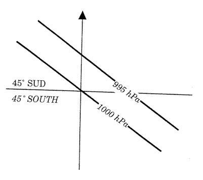
Question 181-22 : Isobars on a surface chart are lines of equal ?
Qff.
Qfe qne qnh
Question 181-23 : A metar message is valid ?
At the time of observation.
For 2 hours. for 9 hours. for the hour following the observation.
Question 181-24 : In a metar message br and hz mean respectively ?
Question 181-25 : In a metar message the wind group is 23010mps this means ?
Wind from 230° true at 20 knots.
Mps metres per second1 kt = 0515 mswind direction provides in a metar is in degrees trueWind from 230° true at 10 miles per hour wind from 230° magnetic at 20 knots wind from 230° magnetic at 10 miles per hour
Question 181-26 : On a significant weather chart we see the following for the area where a vfr flight will take place bkn cu sc 100 023if the flight is planned at fl 85 we can estimate that ?
We will be in solid clouds and consequently a vfr flight is not possible.
Broken bkn = 5 to 7 oktasfrom fl023 up to fl100 we have 5 to 7 oktas cumulus and sratocumulus cloud coverage at fl85 we will certainly have to divert around some cumulus tops and it might be impossible to find a vfr path vfr flight is not possible in those conditionsWe will probably have to divert around some cumulus tops. we will fly just below the cloud base where the cloud cover is between 5 and 7 oktas. we will fly above a solid cloud cover.
Question 181-27 : On the significant weather chart we see the following indications sct cu100060the forecast charts for fl 050 and fl 100 both indicate a wind from 320°15 ktin flight at fl 055 over an area of plains during the validity period of the significant weather chart we observe moderate turbulencethis ?
The instability of the air mass between the surface and the top of cumulus clouds.
The winds at fl050 and fl100 are the same we can exclude the wind shear cumulus clouds from fl060 and fl100 indicate an air mass instabilitySystem waves. a wind shear. the surface radiation.
Question 181-28 : Refer to the following taf message lfxx 180800z 18091818 22020kt 6000 sct015 sct080 bemcg 18121814 24025kt 2000 ra bkn009 ovc070=at 1400 utc the lowest cloud base will be ?
At 900 feet agl.
At 1400 utc forecast cloud bases are becmg 1214 24025kt 2000 ra bkn009 ovc070bkn009 broken 900 ft aglovc070 overcast 7000 ft aglthe lowest cloud base is therefore at 900 feet above groud levelBetween 900 and 1500 feet amsl. between 900 and 1500 feet agl. at 1500 feet agl.
Question 181-29 : The taf weather messages are ?
Airport forecasts.
Hourly or semi-hourly weather observations. special weather observations. landing forecasts of the 'trend' type.
Question 181-30 : The term prob as used in a taf message indicates the probability in percentage of phenomena described during a specific period the numerical values immediately following the term prob are ?
30 or 40.
Icao annex 3 meteorological service for international air navigation the probability of occurrence of an alternative value of a forecast element or elements should be indicated as necessary by use of the abbreviation 'prob' followed by the probability in tens of per cent and the time period during which the alternative value s is are expected to applythe probability information should be placed after the element or elements forecast and be followed by the alternative value of the element or elements the probability of a forecast of temporary fluctuations in meteorological conditions should be indicated as necessary by use of the abbreviation 'prob' followed by the probability in tens of per cent placed before the change indicator 'tempo' and associated time group a probability of an alternative value or change of less than 30 per cent should not be considered sufficiently significant to be indicated a probability of an alternative value or change of 50 per cent or more for aviation purposes should not be considered a probability but instead should be indicated as necessary by use of the change indicators 'becmg' or 'tempo'therefore the numerical values immediately following the term prob are 30 or 40 only20 or 30. 25 or 35. 35 or 50.
Question 181-31 : What type of precipitation might occur at 1700 utc mkjp 160430z 160606 36010kt 9999 few025 becmg 1315 14020g34kt few015cb sct025 prob30 tempo 1720 6000 +shra sct010 bkn015cb becmg 2224 34010kt few025= ?
Question 181-32 : What is the lowest possible cloudbase forecast for 2300 utc eddf 272200z 28062824 vrb05kt4000 br sct005 ovc013 becmg 28132814 9000 shra ovc015 prob40 tempo 28142816 vrb15g25kt 1600 tsra ovc010cb becmg 28162818 26010kt bkn030 becmg 28212822 cavok= ?
5000 feet.
becmg 2122 cavok the lowest possible cloudbase forecast for 2300 utc is 5000 ft in cavok conditions there are no clouds below 5000ft cavok definition is 1 no cloud below 5000 ft above airfield level or minimum sector altitude whichever is higher 2 no cb or tcu at any height3 visibility 10 km or more4 no significant weather3000 feet. 500 feet. 1500 feet.
Question 181-33 : What is the meaning of the expression 'few' ?
1 2 oktas.
3 - 4 oktas. 5 - 7 oktas. 8 oktas.
Question 181-34 : Which of the following layers of fog above land is coded as mifg ?
A layer of 5 feet deep.
Icao annex 3 meteorological service for international air navigation 4426 recommendation in local routine and special reports and in metar and speci the following characteristics of present weather phenomena as necessary should be reported using their respective abbreviations and relevant criteria as appropriate shallow mi less than 2 m 6 ft above ground levelA layer of 10 feet deep. a layer of 15 feet deep. a layer of 20 feet deep.
Question 181-35 : Which of the following phenomena has to be mentioned in a sigmet ?
Heavy duststorm.
Icao annexe 3 met services sigmet or significant meteorological information is a weather advisory that contains meteorological information concerning the safety of all aircraftthe following are examples of weather phenomena that may be described in a sigmet thunderstorms cyclones tropical revolving storms severe turbulence severe icing severe mountain waves dust or sand storms volcanic ashStrong inversion. thick fog. snow and ice on the runway.
Question 181-36 : Which of the following phenomena has to be mentioned in a sigmet ?
Volcanic ash.
Icao annexe 3 met services sigmet or significant meteorological information is a weather advisory that contains meteorological information concerning the safety of all aircraftthe following are examples of weather phenomena that may be described in a sigmet thunderstorms cyclones tropical revolving storms severe turbulence severe icing severe mountain waves dust or sand storms volcanic ashStrong inversion. thick fog. snow and ice on the runway.
Question 181-37 : On an upper wind and temperature chart ?
The pressure is constant all over the chart.
The temperature is constant all over the chart. the height is constant all over the chart. the wind increases from south to north.
Question 181-38 : What is the most likely forecast lowest cloud base that can be expected during an approach to madrid into 2300 utc taf lemd 281200z 281812 13005kt cavok tempo 1821 8000 sct020 sct030 becmg 2123 21005kt 9999 sct015 bkn080 prob40 tempo 2306 6000 sct008 ?
1500 feet.
The tempo group is used for any conditions in wind visibility weather or sky condition which are expected to last for generally less than an hour at a time occasional and are expected to occur during less than half the time period the tempo indicator is followed by a four digit group giving the beginning hour and ending hour of the time period during which the temporary conditions are expected only the changing forecast meteorological conditions are included in tempo groups the omitted conditions are carried over from the previous time groupbecmg 2123 21005kt 9999 sct015 bkn080 prob40 tempo 2306 6000 sct008 sct008 concerns less than half of the period so the most likely conditions to expect will be cloud base to 1500 feet2000 feet. 3000 feet. 800 feet.
Question 181-39 : What is the lowest visibility forecast for bangkok at eta 1400 utc taf vtbd 271800z 28002824 vrb05kt 1200 br tempo 28002802 4000 becmg 28022805 9999 sct015 bkn100 tempo 28112818 04010g20kt 5000 tsra sct009 bkn014 bkn018cb becmg 28202824 6000= ?
5 km.
At eta 1400 utc the taf indicates ' tempo 28112818 04010g20kt 5000 tsra sct009 bkn014 bkn018cb 'the tempo group is used for any conditions in wind visibility weather or sky condition which are expected to last for generally less than an hour at a time occasional and are expected to occur during less than half the time periodit means that between 1100 utc and 1800 utc the visibility could come down to 5000 m and this is the lowest visibility forecast for arrival at 1400 utc1200 metres. 6 km. 10 km or more.
Question 181-40 : What is the lowest probable cloud base forecast for eta 1700 utc at kingston taf mkjp 160000z 16061706 36010kt 9999 few025 becmg 16131615 14020g34kt few015cb sct025 prob30 tempo 16151620 6000 +shra sct010 bkn015cb becmg 16231701 34010kt few025= ?
1000 ft.
The lowest probable cloud base forecast for eta 1700 utc at kingston is 1000 ft'becmg 16131615' changes the lowest cloud base to 1500 ft 1 to 2 oktas few015cb but there is a 30% probability prob30 tempo that there could be 3 to 4 oktas at 1000 ft sct010 1000 m. 1500 ft. 1500 m.
Exclusive rights reserved. Reproduction prohibited under penalty of prosecution.