A free Premium account on the FCL.055 website! Read here
Sign up to unlock all our services and 15164 corrected and explained questions.
Question 186-1 : A great circle track crosses the equator at 30°w has an initial track of 035°t it's highest or lowest northsouth point is ? [ Question security ]
55°n 060°e
Question 186-2 : The latitude of the tropic of capricorn is ?
235°s.
23,5°n. 66,5°n. 66,5°s.
Question 186-3 : Which statement is true ?
The declination of the sun and the latitude of the observer will affect the duration of civil twilight.
The duration of the civil twilight on 21st of march and on 23rd of september is equal at all places on earth independent of latitude. only the declination of the sun will affect the duration of civil twilight. civil twilight at the equator lasts longer than at 60°n or 60°s because the radius of the equator is larger than the radius of the 60°parallel.
Question 186-4 : At 00h00 local mean time of an observer ?
The mean sun is in transit with the observer's anti meridian.
Local mean time is solar time as measured by the position of the mean sun with respect to an observer's local meridian local mean time differs continuously with the observer's longitude and is not standardized over a time zone however a day as measured by local mean time does not vary in length throughout the year it is always 24 hours and at midnight 00h00 it will be on the observer's anti meridianThe apparent sun is in transit with the observer's anti-meridian. the mean sun is in transit with the observer's meridian. the apparent sun is in transit with the observer's meridian.
Question 186-5 : Kepler's second law states that ?
The radius vector sun earth sweeps out equal areas in equal time.
The radius vector sun-earth moves at constant angular speed. the length of the radius vector sun-earth is directly proportional to the square root of its angular speed. the area swept out by the radius vector sun-earth per hour increases with increasing length of the radius vector.
Question 186-6 : Consider the positions 00°ns 000°ew and 00°ns 180°ew on the ellipsoid which statement about the distances between these positions is correct ?
The route via the north pole is shorter than the route along the equator.
Since earth shape is an ellipsoid the distance from position a 00°ns 000°ew to b 00°ns 180°ew both located on the equator will be shorter via the poles com encom061 587jpgThe route via the equator is shorter than the route via the south pole. the route via either pole and the route via the equator are of equal length. the route via the south pole is shorter than the route via the north pole.
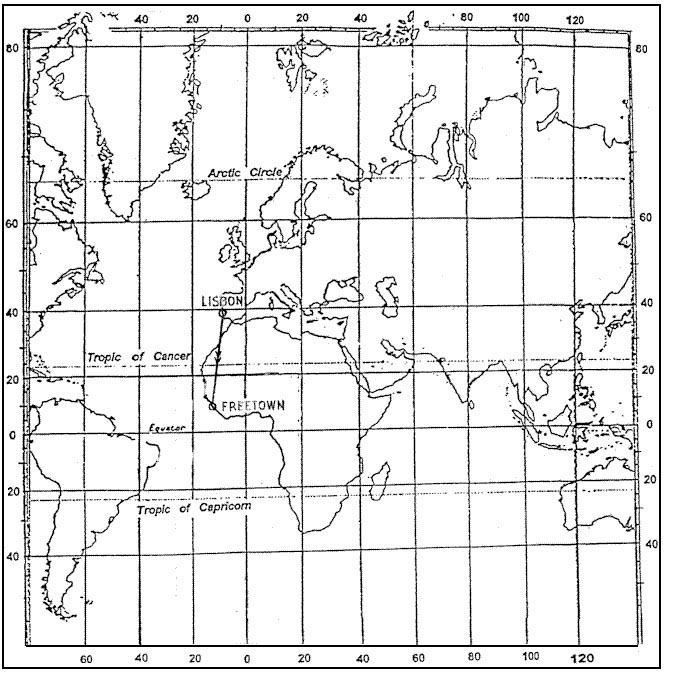
Question 186-7 : The srss sunrisesunset table for the 23rd of february at latitude 40°n gives sr = 06 44ss = 17 44at 12 00 central european time utc+1 at 40°n ?
The sun rises at 64°w.
Sr and ss are given in utc so we need to know first the central european time in utc when it is 11 00 utc it's 12 00 local time in central europe utc+1 now in central europe the sun rises at 06h44 utc so 4h and 16 minutes later at 11 00utc where does the sun is rising answer we must be near the north american and canadian border close to the coast4h and 16 minutes = 256 minuteswhat is the speed of the trace of the sunrise on the ground 1440 minutes per day 24h per day 360° to cover for a complete turn of the sun around the earth so 1440360 = 4 minutes par degree2564 = 64°when it is 11 00 utc the sun rises at 64° west of our positionThe sun rises at 79°w. the sun sets at 86°e. the sun sets at 116°e.
Question 186-8 : An aircraft follows a great circle in the northern hemisphere at a certain moment the aircraft is in the position on the great circle where the great circle direction is 270° t continuing on the great circle the ?
Track angle will decrease and the latitude will decrease.
com encom061 594jpgfollowing a great circle track in the northern hemisphere your heading will decrease track angle will decrease and the latitude will decrease tooTrack angle will increase and the latitude will decrease. track angle will decrease and the latitude will increase. track angle will increase and the latitude will increase.
Question 186-9 : On an oblate spheroid representing the earth's shape ?
1 minute of arc along the equator measures a greater distance than 1 minute of arc along the meridian at a latitude of 45°ns.
The earth is a tad wider than it is tall giving it a slight bulge at the equator this shape is known as an ellipsoid the diameter from the north pole to the south pole the shortest diameter is approximately 6860 nm and the equatorial diameter the longest diameter is approximately 6883 nmthe polar circumference is 21554 nm each minute of arc being equal to 0998 nmthe equatorial circumference is 21626 nm each minute of arc being equal to 1001 nm1 minute of arc along the equator measures the same distance as 1 minute of arc along the meridian at a latitude of 45°n/s. 1 minute of arc along the meridian at low latitudes measures a greater distance than 1 minute of arc along the meridian at high latitudes. 1 minute of arc along the meridian at 0°n/s measures the same distance as 1 minute of arc at 90°n/s.
Question 186-10 : Given a 56°n 145°e b 57°n 165°w what is the difference in longitude between a and b ?
050°.
We only want to know the difference in longitude between a and b is 50° not the distance between a and b so latitudes are irrelevant from a longitude to reach the anti meridian 180°ew we have 35° of longitude and then to reach b longitude we have 15° of longitude35° + 15° = 50°020°. 130°. 001°.
Question 186-11 : What is the duration of morning civil twilight at 66°48'n 095°26'w on 27th of january 2480 ?
01h 13m.
1809at 67°n on january 26th the duration of morning civil twilight is 1h14 minwe are looking for january 27th you can continue to interpolate with january 28th but if you look at the sunrise difference time between 26th and 28th at 66°n you gain 11 minutes now for the morning civil twilight between 26th and 28th at 66°n you gain 7 minutesso for january 27 th 1h13 minutes sounds good08h 14m. 09h 27m. 01h 02m.
Question 186-12 : The gmt of morning civil twilight at 66°48'n 095°26'w on 27th of january is err a 061 605 ?
1436 gmt.
The answers are all in gmt so take the time from the annex and adjust for longitude at 15°h 95°26' 15 = 6h 22minas the location is west of the prime meridian the answer must be later in the day reference to gmt 0814 + 6 hrs 22 = 1436 gmt notice 0814 is calculated by interpolation 0927 gmt. 1541 gmt. 0814 gmt.
Question 186-13 : The gmt of sunrise at 66°48'n 095°26'w on 27th of january is err a 061 606 ?
1549 gmt.
Sunrise at 66°48'n 095°26'w on 27th of january com encom061 606jpginterpolation between 26th and 29th january difference at 68n is 13 minutes for 4 days so for one day is 325 minutes difference at 66n is 11 minutes for 4 days so for one day is 275 minuteswe are looking for 66°48'n 3 minutes is a good deal09h19 66°n to 9h45 68°n on january 26th at 66°48' it will be 09h32 and 09h29 on january 27th now convert local mean time lmt at longitude 095°26'w 954° x 4 minutes = 3816 minutes3816 minutes = 636 hours = 6 h 22 minutes09h29 + 6h22 = 15h51 utc 0927 gmt 1541 gmt 0814 gmt
Question 186-14 : The latitude of the tropic of cancer is ?
235°n.
23,5°s. 66,5°n. 66,5°s.
Question 186-15 : Position a is 31°00's 176°17'w rhumb line track t from a to b is 270°initial great circle track t from a to b is 2662°the approximate position of b is ?
31°00's 168°58'e.
Difference between the great circle track and rhumb line track is conversion angle conversion angle = 270° 2662° = 38°12g sin 31° = 38°g change of longitude12g = 38° sin 31°12g = 738°g = 1476°176°17'w + 1476° or 14°45' = 168°58'est(31°00's, 161°32'w) (31°00's, 173°24'w) (31°00's, 173°24'e)
Question 186-16 : An aircraft departs from schiphol airport and flies to santa cruz in bolivia south america via miami in floridathe departure time off blocks is 07h45 st utc + 1 at the 10th of november taxi time before take off at schiphol is 25 minutes the flight time to miami over the atlantic ocean is 09h20m the ?
21h05 10th nov.
Cmarzocchini i only did 06h45 utc off blocks + 00h25 + 09h20 + 00h25 + 02h40 + 06h30 = 26h05in santa cruz bolivia utc +5 so 26h05 5h = 21h05 same day22h05 10th nov. 07h05 11th nov. 09h05 11th nov.
Question 186-17 : Two places on the parallel of 47°s lie 7578 km apart calculate the difference in longitude ?
10°00'.
First convert km in nm 7578 km 1852 = 409 nmdistance = change of longitude x cos of latitude409 nm = change of longitude x cos 47°change of longitude = 409 cos 47° = 600 minutes600 60 min per degree = 10°4°39'. 9°19'. 4°51'.
Question 186-18 : In a sunrisesunset table given for the 28th of june at a certain latitude sunrise is gven as 0239 and sunset is given as 2127what is the latitude ?
60°n.
It must be in the northern hemisphere because it's summer and 28th of june it's quite a long period of daylight but at 80 degrees north you have mid summer night this is where the sun never goes below the horizon i think that's why the answer is 60 degrees north absolutly we are close to the longest day during summer time in the northern hemispherefurthermore above 665°n in summer it is permanent daylight80°n. 55°s. 00° n/s.
Question 186-19 : On the earth's ellipsoid one degree of latitude near the equator is ?
Less than 60 nm.
At the equator one degree of latitude = 11057 km or 597 nmat 50°n or 50°s one degree of latitude = 11123 km or 6005 nmat the poles one degree of latitude = 11169 km or 603 nmthe geoid is an ellipsoidal form so a degree of latitude centered on the equator is not the same length as one degree of longitude along the equator the difference is small enough to ignore for many applications60 nm. more than 60 nm. more than 60 nm but less than 61 nm.
Question 186-20 : With an increase in magnetic latitude there will be a decrease in the ?
Directive force.
The directive force is the horizontal component of the earth's magnetic field the horizontal component of the earth's magnetic field is stronger at magnetic equator and very weak at the magnetic polesthus if you are heading to the magnetic poles your latitude is increasing there will be a decrease in the directive forceAngle of dip. vertical component of the earth's magnetic field. total magnetic force of the earth's magnetic field.
Question 186-21 : Which statement about the duration of daylight is true ?
Close to the equinoxes the influence of latitude on the duration of daylight is at its smallest.
Close to the solstices the influence of latitude on the duration of daylight is at its smallest. on september 10th the duration of daylight is longer on the southern hemisphere than on the northern hemisphere. in summer the length of the period of daylight decreases with increasing latitude.
Question 186-22 : Which figure in the appendix represents the geocentric latitude of position p which is situated above the surface of the ellipsoid err a 061 662 ?
Figure b.
Geocentric latitude is measured from the centre of the ellipsoid geodetic or geographic latitude which is what is normally measured is the angle between the plane of the equator and the line which is normal to the ellipsoid at the point of interest unlike geocentric latitude this line does not typically pass through the centre of the ellipsoid whenever the unqualified term latitude is used it will normally mean the geographic latitude com encom061 662jpgon the wgs84 ellipsoid the length of a degree of latitude increases from 110574 km at the equator to 111694 km at the poles geographic and geocentric latitudes can differ by as much as 12 minutes of arc an amount equivalent to a distance of more than 30 km on the groundFigure a. figure c. figure d.
Question 186-23 : Which figure in the appendix represents the geographic latitude of position p which is situated above the surface of the ellipsoid err a 061 663 ?
Figure a.
Geographic latitude is define as the angle between the plane of the equator and the local plumb line on the ellipsoidon figure a you can notice that the local plumb line intersects the plane of the equator not in the center of the sphere because earth is an ellipsoidFigure b. figure c. figure d.
Question 186-24 : The long term periodic change in the earth's magnetic field ?
Is reflected in the slow movement of the magnetic poles.
Feedback pour traduction fr 'a quoi est dûe la variation du champ magnétique terrestre au déplacement lent et progressif des pôles magnétiques'Is caused by sunspot activity. is caused by the westerly movement of the geographic north pole. affects mainly the compass deviation.
Question 186-25 : The horizontal component of the earth's magnetic field ?
Is very small close to the magnetic poles.
com encom061 593jpgdiagrammatic representation of the earth's magnetic field illustrating how field lines represented by arrows intersect the earth's surface and how inclination angle the angle formed between the field lines and the earth varies with latitude at the magnetic equator the curving line across the earth field lines are parallel to the earth's surface the field lines become progressively steeper as one travels north toward the magnetic pole where the field lines are directed straight down into the earth and the inclination angle is 90° near the magnetic pole the horizontal component of the earth's magnetic field is too small to permit the use of a magnetic compass Is maximum at the magnetic poles. is minimum at the magnetic equator. increases with an increase of the magnetic latitude.
Question 186-26 : An observer is situated on the parallel of 235°s which statement about the passage of the apparent sun in relation to this position is correct ?
It passes through the zenith once a year around december 22nd.
It passes through the zenith twice a year around june 21st and december 22nd. it passes through the zenith once a year around march 21st. it passes through the zenith twice a year around march 21st and september 23rd.
Question 186-27 : At 54°n 020°w the sun rises on november 28th at 09 01 utcat 44°n 020°w the sun will rise ?
Earlier since the latter position lies further south.
On november 28th we are approaching winter solstice 21 22 december 1781the axis of the earth is tilted 235° degrees from 'vertical' this causes the northern hemisphere to be tilted toward the sun during half the year and tilted away from the sun the other half of the yearafter autumnal equinox northern hemisphere is tilted away and as you can see on this picture position '44°n 020°w' will see the sun rising earlier than the position '54°n 020°w'Later since the latter position lies further south. also at 09:01 utc since both positions are situated on the same meridian. at 07:41 lmt.
Question 186-28 : What is the correct definition of latitude of a position on the earth ?
Latitude is the angle between the plane of the equator and the line from the centre of the earth to the position.
Latitude is the angle between the earth's rotational axis and the line from the centre of the earth to the position. latitude is the angle between the plane of the prime meridian and the plane of the meridian of the position. latitude is the angle between the plane of the ecliptic and the parallel of the position.
Question 186-29 : When proceeding on a given date along a parallel towards the east the moment of sunrise will occur one hour earlier every 15° difference in longitude when it is expressed in ?
Utc.
Lmt standard time lat (local apparent time)
Question 186-30 : The maximum difference in distance when proceeding along the great circle between two positions in stead of the rhumb line will occur ?
On east west tracks at high latitudes.
Img com encom061 674jpggreen great circle trackred rhumb lineright answer is east west track at high latitudes but west east track at high latitudes will also be rightOn north-south tracks at high latitudes. on east-west tracks at low latitudes. on north-south tracks at low latitudes.
Question 186-31 : Geodetic latitude and geocentric latitude coincide ?
At the poles and on the equator.
Only at the poles. only on the equator. at 45°n/s.
Question 186-32 : The time difference in local mean time between sunset at positions a 50°n 120°e and b 50°s 120°e on the 21st of november is ?
Some hours and the sun rises earlier in b than in a.
On the 21st of november it's winter in northern hemispheretiming of sunsets and sunrises are driven by the axial tilt of earth in the summertime the days get longer and sunsets occur laterthus since it is summer in southern hemisphere the sun will rise earlier in b than a and the sun will disappear earlier in a than in bSome hours and the sun rises earlier in a than in b. negligible small because a and b are located at the same meridian. negligible small because a and b are located symmetrically to the equator.
Question 186-33 : Which statement about standard time is true ?
Standard time is determined by the government of the appropriate state and does not necessarily follow the borders of 15° wide longitude zones.
The local time at 125°w is utc 8h20m the standard time is determined by the government of the appropriate state and does not necessarily follow the borders of 15° wide longitude zonesStandard time is the time that is determined by division of the longitude by 15 and rounding off the answer to the nearest integer. the standard time at 125° w is utc -8h20m. in all cases the standard times at western longitudes are slow on and at eastern longitudes fast on utc.
Question 186-34 : Which statement is correct about the apparent solar day ?
The apparent solar day is the period between two successive transits of the true sun through the same meridian.
The apparent solar day is the period between two successive transits of the mean sun through the same meridian. the duration of the apparent solar day is constant throughout a year due to the constant velocity of the earth in its orbit around the sun. the duration of the apparent solar day is constant throughout a year due to the constant rotational speed of the earth around its axis.
Question 186-35 : Which statement regarding the apparent sun and the mean sun is correct ?
The apparent sun is the visible sun the mean sun is a fictitious sun.
Apparent sun 'apparent solar time' or 'true solar time' is given by the daily apparent motion of the true or observed sun it is based on the apparent solar day which is the interval between two successive returns of the sun to the local meridianthe mean sun is imaginary sun moving along the celestial equator at a constant rate and completing its annual course in the same time as the sun takes to move round the ecliptic at a varying rate it is used in the measurement of mean solar timemean solar time conceptually is the hour angle of the fictitious mean sun the duration of daylight varies during the year the length of a mean solar day is nearly constant unlike that of an apparent solar dayThe apparent sun is a fictitious sun coupled to utc, the mean sun is related to the local mean time. the mean sun moves along the ecliptic, the apparent sun along the celestial equator. the apparent sun is not important for navigation as difference in time with the mean sun is maximal 4 seconds.
Question 186-36 : The declination of the sun is defined as ?
The angular distance of the sun north or south of the celestial equator.
com encom061 682gifdirectly above the equator of the earth we find the celestial equator in the skydeclination of the sun is the angular distance of the sun north or south of the celestial equator com encom061 682ajpgthe earth's equator is tilted 235 degrees with respect to the plane of the earth's orbit around the sun so at various times during the year as the earth orbits the sun declination varies from 235 degrees north to 235 degrees south com encom061 682bjpgthis gives rise to the seasons around december 21 the northern hemisphere of the earth is tilted 235 degrees away from the sun which is the winter solstice for the northern hemisphere and the summer solstice for the southern hemisphere around june 21 the southern hemisphere is tilted 235 degrees away from the sun which is the summer solstice for the northern hemisphere and winter solstice for the southern hemisphere on march 21 and september 21 are the fall and spring equinoxes when the sun is passing directly over the equator note that the tropics of cancer and capricorn mark the maximum declination of the sun in each hemisphereThe arc of the meridian of the sun measured from the nearest pole to the sun. the arc from the celestial horizon to the sun measured along a vertical line perpendicular on the horizon. the arc along the celestial sphere from zenith to the sun.
Question 186-37 : The time interval between sunrise and sunset is dependent on ?
The declination of the sun and the latitude of the observer.
Depending on your location the times of sunrise and sunset and the length of the daylight period varies in a sine wave patternthe axis of spin of the earth is not vertical to the plane between the earth and the suneven though the earth spins on that axis and rotates around the sun the tilt of the axis never changes because of this the northern and southern hemispheres are exposed to more or less sunlight at different timesas a result when the top of the earth is in a position where it is closer to the sun the sun's light rays strike well above the equator resulting in summer and longer days com encom061 684gifwhen it is summer in the northern hemisphere it is winter in the southern hemisphereThe date and the longitude of the observer. the latitude and the longitude of the observer. the inclination of the axis of the earth and the longitude of the observer.
Question 186-38 : The definition of true north for any observer is ?
The direction of the observer's meridian to the north pole.
True north may in practical terms be magnetic north corrected for local variation but that is not the definition the definition is 'the direction from the observer to the geographic north pole along the local meridian'The direction of the greenwich meridian to the north pole. the direction of the observer's magnetic north corrected for local variation. the reading of the observer's compass corrected for deviation and local variation.
Question 186-39 : A definition of a magnetic track angle is ?
The direction of a line referenced to magnetic north.
Magnetic track angle the angle measured in a clockwise direction between the track and magnetic north the direction of the longitudinal axis of an aircraft referenced to magnetic north is the magnetic heading of the aircraft the direction of the longitudinal axis of an aircraft referenced to compass north is the compass heading of the aircraftThe direction of the longitudinal axis of an aircraft referenced to magnetic north. the direction of the longitudinal axis of an aircraft referenced to compass north. the direction of a line referenced to the isogonic line to the magnetic north pole.
Question 186-40 : The main reason for the occurrence of seasons on earth is ?
The inclination of the earth axis with regard to the plane of the ecliptic.
The distance between the sun and the earth. the elliptical form of the orbit of the earth around the sun. the length of the day as stated by the second law of kepler.
Exclusive rights reserved. Reproduction prohibited under penalty of prosecution.