Sign up to unlock all our services and 15164 corrected and explained questions.
Question 100-1 : Use route manual chart e hi 2 .an aircraft has to fly on airways from alma 55°25'n 013°34'e to shilling 57°33'n 014°00'e what is the distance between these two points . 1493 ? [ Exam pilot ]
Question 100-2 : For this question use trm athinai hellinikon area chart 29 1 .what is the maximum permitted altitude if routeing inbound from 'abeam patroklos' to hellinikon . 2466 ?
Question 100-3 : The route distance from chievres civ to boursonne bsn is . 1492 ?
Question 100-4 : Use route manual chart e hi 2 .an aircraft has to fly from alma 55°25'n 013°34'e to backa 57°33'n 011°59'e on airways ub45 uh40 and ua9 .what is the total track distance for this flight . err a 033 98 ?
Question 100-5 : Use route manual chart e hi 1 .an aircraft has to fly from tiree 56°29'n 006°53'w direct to aberdeen 57°19'n 002°16'w .what is the minimum grid safe altitude for this route . err a 033 103 ?
5700 ft
Question 100-6 : Route manual chart e hi 4 caa edition .the magnetic course/distance from tango tgo 112 5 48°37'n 009°16'e to dinkelsbuhl dkb 117 8 49°09'n 010°14e on airway ur11 is . err a 033 105 ?
Question 100-7 : Route manual star chart for madrid barajas 10 2a b .for runway 33 arrivals from the east and south the initial approach fix iaf inbound from airway ur10 is . err a 033 107 ?
Vtb
Question 100-8 : Use route manual chart e hi 2.an aircraft has to fly from shilling 57°33'n 014°00'e to alma 55°25'n 013°34'e .what is the minimum grid safe altitude for this route . 1493 ?
Question 100-9 : Use route manual chart e hi 1.the initial true course from tiree 117 7 tir 56°30'n 006°53'w direct to inverness 109 2 ins 57°32'n 004°03'w is . err a 033 115 ?
Question 100-10 : Route manual chart e lo 5. an appropriate flight level for flight on airway g9 from subi sui 116 7 52°23'n 014°35'e to czempin cze 114 5 52°08'n 016°44'e is . err a 033 121 ?
Fl70
Question 100-11 : Route manual chart madrid barajas ils dme rwy 33 11 1 .the minimum glide slope interception altitude for a full ils is . err a 033 135 ?
Question 100-12 : Use route manual chart e lo 1.the distance on airway b4 from pole hill 112 1 pol n53°45' w002°06' to shapp n54°30'w002°38' is . 1494 ?
Question 100-13 : Route manual chart e lo 6.the magnetic course/distance from grostenquin gtq 111 25 49°00'n 006°43'e to linna 49°41'n 006°15'e on airway r7 is . err a 033 149 ?
Question 100-14 : Use route manual chart e hi 2. what is the meaning of the chart information for the navaid s landvetter 57°39'n 012°17'e . err a 033 154 ?
Question 100-15 : For this question use route manual chart e hi 2.the radio navigation aid at 57°45'n013°48'e is a . err a 033 156 ?
Question 100-16 : Use route manual chart e hi 1 .the initial true course from inverness 109 2 ins 57°32'n004°03'w direct to tiree 117 7 tir 56°30'n006°53'w is . err a 033 158 ?
Question 100-17 : Route manual sid chart for munich 10 3c 10 3d . which is the correct departure via kempten from runway 26l . err a 033 161 ?
Question 100-18 : Route manual chart 5 at hi .on airway pts p from vigra 62°33'4n 006°02'e the initial great circle grid course . err a 033 175 ?
Is 344°
Question 100-19 : Route manual chart e lo 5.the ndb at denko 52°49'n 015°50'e can be identified on . err a 033 176 ?
Question 100-20 : Route manual chart amsterdam jaa minimums 10 9x .the radio altimeter minimum altitude for a cat 2 ils dme approach to rwy 01l is . err a 033 181 ?
100 ft
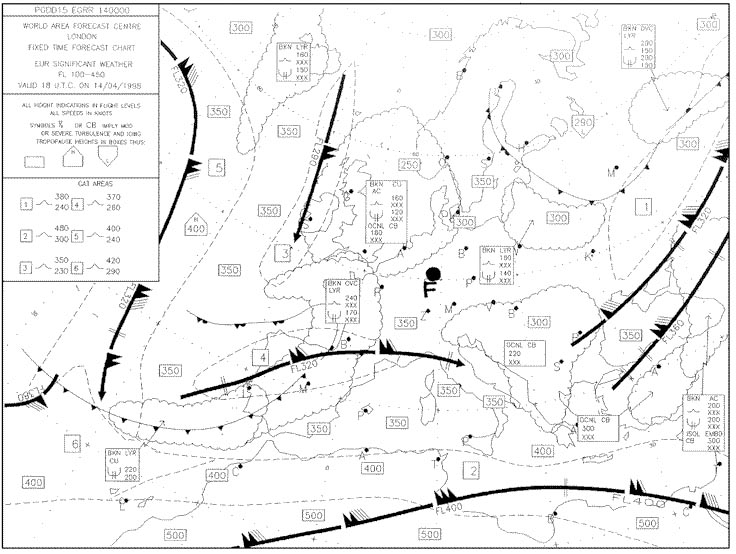
Question 100-21 : On an instrument approach chart a minimum sector altitude 'msa' is defined in relation to a radio navigation facility .without any particular specification on distance this altitude is valid to ?
Question 100-22 : Route manual chart e lo 2. an appropriate flight level for flight on airway b3 from chatillon ctl 117 6 49°08'n 003°35'e to cambrai cmb 112 6 50°14'n 003°09'e is . err a 033 199 ?
Question 100-23 : For this question use route manual chart e hi 2.the radio navigation aid s at 56°09'n 013°14'e is/are . err a 033 200 ?
Question 100-24 : An airway is marked 5000 2900a the notation 5000 is the ?
Question 100-25 : Route manual chart e hi 4 caa edition. the radio navigation aid at chioggia 45°04'n 012°17'e is a . err a 033 206 ?
Question 100-26 : Route manual chart e lo 6.an appropriate flight level for flight on airway w37 from cheb okg 115 7 50°04'n 012°24'e to roding rdg 114 7 49°02'n 012°32'e is . err a 033 209 ?
Question 100-27 : Use route manual chart e hi 2 .an aircraft has to fly on airways from skara 58°23'n 013°15'e to sveda 56°10'n 012°34'e .once airborne if approved which of the following is an acceptable route for this flight . err a 033 210 ?
Question 100-28 : Use route manual chart e lo 1.the radio navigation aid at leeds bradford 53°52'n 001°39'w is . err a 033 214 ?
Question 100-29 : Use route manual chart e lo 1 .the magnetic course from dean cross 115 2 dcs 54°43'n 003°20'w° to newcastle 114 25 new 55°02'n 001°41'w on airway w911d is . err a 033 219 ?
Question 100-30 : Route manual sid chart for london heathrow 10 3 .which of the following is a correct minimum safe altitude msa for the airport . err a 033 221 ?
Question 100-31 : Route manual chart star london heathrow 10 2 .planning a ifr flight from paris charles de gaulle to london heathrow . find the elevation of the destination aerodrome . err a 033 224 ?
Question 100-32 : Use route manual chart e hi 1.an aircraft has to fly from beacon ben 57°29'n 007°22'w to beacon adn 57°19'n 002°16'w .what is the average true course for this route . err a 033 226 ?
Question 100-33 : Route manual chart e hi 4 caa edition. the radio navigation aid stad 51°45'n 004°15'e is . err a 033 227 ?
Question 100-34 : Route manual sid chart for amsterdam schiphol 10 3b .the route distance from runway 27 to arnem is . err a 033 231 ?
Question 100-35 : Route manual chart e hi 4 caa edition.the radio navigation aid at zurich 47°36'n 008°49'e is . err a 033 234 ?
Question 100-36 : Use route manual chart e hi 1.the initial true course from tiree 117 7 tir 56°30'n006°53'w direct to stornoway 115 1 stn 58°12'n006°11'w is . err a 033 235 ?
Question 100-37 : Route manual chart e hi 4 caa edition.the magnetic course/distance from salzburg sbg 113 8 48°00'n 012°54'e to staub 48°44'n 012°38'e on airway ub5 is . err a 033 238 ?
Question 100-38 : Route manual chart paris charles de gaulle ils rwy 10 21 8 . the ils localizer course is . err a 033 241 ?
Question 100-39 : Route manual chart 5 at hi .the initial great circle true course from keflavik 64°00'n 022°36'w to vigra 62°33'n 006°02'e measures 084° .on a polar enroute chart where the grid is aligned with the 000° meridian the initial grid course will be . err a 033 242 ?
106°
Question 100-40 : Use route manual chart e hi 1.the initial magnetic course from tiree 117 7 tir 56°30'n006°53'w direct to stornoway 115 1 stn 58°12'n006°11'w is . err a 033 243 ?
~
Exclusive rights reserved. Reproduction prohibited under penalty of prosecution.
3959 Free Training Exam

