A free Premium account on the FCL.055 website! Read here
Sign up to unlock all our services and 15164 corrected and explained questions.
Question 101-1 : Consider the curve for the thrust required versus speed for a jet aeroplane what speed can be obtained from the minimum of this curve the speed for ? [ Exam pilot ]
Max endurance because fuel flow is proportional to thrust at the minimum
Question 101-2 : To achieve the maximum range over ground with headwind the airspeed should be… ?
Higher compared to the speed for maximum range cruise with no wind.
wind is the horizontal movement of the air in which the aeroplane is operating the specific air range sar is not affected by wind because it depends on nmkg of fuel or tasfuel flow the specific ground range sgr is affected because it depends on nmkg fuel or groundspeedfuel flowa headwind reduces the sgr while a tailwind increases the sgr considering sgr with a headwind the tangent starts to the right of the graph origin by the amount of the wind strengththe example above is for a 100 kt headwind however the tangent to the drag curve now occurs at a speed faster than 132 vmd but the speed increment is less than the wind strengthby flying at this slightly faster speed the sgr is maximum for the given headwind conditions although still less worse than in still air this occurs because for every minute the aeroplane is in a headwind the wind is pushing it backward therefore the shorter the time exposed to the wind the shorter the distance it is pushed backLower compared to the speed for maximum range cruise with no wind. equal to the speed for maximum range cruise with no wind. reduced to the gust penetration speed.
Question 101-3 : Considering a jet transport aeroplane specific fuel consumption sfc ?
Is the fuel flow per unit of thrust.
Specific fuel consumptionspecific fuel consumption sfc in a jet is the fuel flow per unit of thrust while sfc for a propeller is the fuel flow per unit of powerthe sfc is only an engine consideration and is not affected by drag which is an airframe considerationin a turbojet engine sfc is lowest when the air temperature is low and the engine is running at its design rpm of approximately 90 to 95% rpm this means that sfc is proportional to temperatureit also means that the engine is most efficient at high altitude where the thrust required to overcome drag is approximately 90 to 95% of the thrust availableIs the nautical miles per unit mass of fuel. is the tas per unit of fuel flow. is the nautical miles per unit of fuel flow.
Question 101-4 : Compared with still air the effect a headwind has on the values of the maximum range speed and the maximum gradient climb speed respectively is that ?
The maximum range speed increases and the maximum gradient climb speed is not affected.
Wind effect on cruisewind does not affect endurance but is one of major factors affecting the aircraft range to understand how the best range speed varies with wind groundspeed should be plotted on the bottom of the drag graph and not tassimilar to no wind conditions at the tangent of curve you can find the speed for best range speed but taking into account the wind a headwind makes the tangent hit the curve at a higher tas and for a tailwind at a slower tasrate of climb is air mass related function of tas and not affected by windThe maximum range speed decreases and the maximum gradient climb speed increases. the maximum range speed decreases and the maximum gradient climb speed decreases. the maximum range speed decreases and the maximum gradient climb speed is not affected.
Question 101-5 : The take off distance available toda is the length of the take off run available plus the length ?
Of the clearway if provided.
Refer to figuresicao annex 14volume 1declared distancesa take off run available tora the length of runway declared available and suitable for the ground run of an aeroplane taking offb take off distance available toda the length of the take off run available plus the length of the clearway if providedc accelerate stop distance available asda the length of the take off run available plus the length of the stopway if providedd landing distance available lda the length of runway which is declared available and suitable for the ground run of an aeroplane landingsummary tora = take off run availabletoda = tora + cwy clearway asda = tora + stw stopway lda = tora displaced thresholdNecessary to retract the gear. necessary to reach 50 ft. of the stopway, if provided.
Question 101-6 : Given the following values calculate the slope of runway 34 runway 16 asda = 1 700 m toda = 1 800 m tora = 1 400 m threshold elevation = 146 ftrunway 34 asda = 1 600 m toda = 2 000 m tora = 1 500 m threshold elevation 34 ft ?
244% upslope.
For runway slope calculations we use the distance between thresholds meaning that we do not include the distance corresponding to the displaced thresholdtora rwy 16 = 1400 mtora rwy 34 = 1500 mtherefore rwy 34 has a displaced thresholdthreshold to threshold distance = 1400 mslope = distance between threshold elevations ft distance between thresholds ft x 100slope = 146 – 34 1400 x 328 x 100slope = 244%the threshold of rwy 34 is lower than the threshold of runway 16 => therefore it is an upslope2.44% downslope 2.28% downslope 2.28% upslope
Question 101-7 : A departure procedure require a climb gradient of 46% to 1300 ft in order to maintain obstacle clearancegiven the data below estimate the minimum rate of climb requiredtas 125 kt average headwind component 25 kt ?
465 ftmin.
A steady continuous head wind or tail wind will not affect your climb rate only your climb angle however to calculate the minimum rate of climb requested to cross an obstacle groundspeed is considered because it is ground flight path relatedmethod 1 accurate required gradient of climb = required rate of climb ftmin ÷ gs kt x 6 000 ÷ 6 080 46 6 000 ÷ 6 080 = required rate of climb ftmin ÷ 100466 = required rate of climb ftmin ÷ 100required rate of climb ftmin = 466 x 100 = 466 ftminmethod 2 simplified wind effective gradient % = rate of climb ftmin ÷ gs kt 46% = rate of climb ftmin ÷ 100 ktrate of climb ftmin = 460 ftmin575 ft/min 280 ft/min 690 ft/min
Question 101-8 : Which factor must be applied if not stated differently in afm for a performance class b aeroplane when taking off on a runway with 2% upslope ?
110.
Regulation eu no 9652012amc2 catpola305 take offrunway slopeunless otherwise specified in the afm or other performance or operating manuals from the manufacturer the take off distance should be increased by 5% for each 1% of upslope except that correction factors for runways with slopes in excess of 2% should only be applied when the operator has demonstrated to the competent authority that the necessary data in the afm or the operations manual contain the appropriated procedures and the crew is trained to take off in runway with slopes in excess of 2% a 5% increase corresponds to a factor of 105 and a 10% increase equals a factor of 1100.95 1.05 1.00
Question 101-9 : What issues you may experience with the take off if you were to pick up a new aircraft from a factory in europe on a cold day ?
A high vmcg which may lead to controllability issues in the event of an aborted take off.
Vmcg is defined as the minimum speed whilst on the ground that directional control can be maintained using only aerodynamic controls with one engine inoperative critical engine on two engine airplanes and take off power applied on the other engine s vmcg is an indicated air speed so theoretically it would not be affected by air density however if an engine failure occurs the engine can produce more power in higher air density which means that the yawing moment in higher air density will also be larger and the force produced on the rudder is greater the angle of attack of the rudder is limited by its maximum deflection therefore a higher speed will be needed to create more counter yawing force on the rudder and maintain the aircraft under controlA high v2 giving good aircraft performance. a high vmca which will make reaching acceleration altitude easier. a low vr making an engine failure easier to handle.
Question 101-10 : For a propeller aircraft the speed for maximum endurance which gives the greatest endurance time is ?
Found at a low altitude.
Fuel flow is largely proportional to engine power which in turn is largely proportional to power required there are some efficiencies involved but that depends on the exact combination of engine and prop we're interested in the general rule here theoretical power required is tas x drag not ias drag is determined by ias however therefore maximum endurance is reached by finding an optimum of the product ias x drag and then making sure tas is as small as possible for this ias at higher altitude a given ias results in a higher tas and consequently more power required to minimise power required and fuel burn increasing our endurance the aircraft should fly at lower altitudes maximum edurance for a propeller aircraft is at sea levelAltitude is irrelevant. dependant on the oat. found at a high altitude.
Question 101-11 : The best endurance for a jet is found ?
At high altitudes.
Endurance is the time that aircraft can remain airborne with the fuel available it will be greatest when the fuel is used at the lowest possible rate that is the fuel flow is minimum the fuel flow depends on the thrust increasing altitude decreasing air density increases the endurance due to the increase in jet engine efficiencyIn an oei scenario. altitude is not relevant. at low altitudes.
Question 101-12 : You are on the downwind leg at addison airport in texas and you notice you have a significant tailwind when the final turnbase leg is complete and you are on final what would you expect to have to do ?
You would expect to have to increase the engine thrust to stay on the correct flight path because with the headwind the ground path will tend to decrease.
A tailwind in the downwind leg translates into a headwind situation on final note that you are heading opposite directions if no correction to thrust are made and the pilot uses a 'still air' setting the headwind reduces the groundspeed and the previously calculated still air rate of descent will cause you to descend below the glideslopekeep in mind the formula for target rate of descent on a 3° glideslope rod = 5 x groundspeed for example if ias on final equals 120 kt the still air groundspeed on final is 120 kt and the required rate of descent = 5 x 120 = 600 ftmin now if the pilot experiences a headwind of 20 kt the ias will equal 120 kt the groundspeed will be 100 kt and consequently the required rate of descent = 5 x 100 = 500 ftmin a rate of descent of 500 ftmin requires more thrustpower applied than a 600 ftmin rod therefore more thrust is required on final with a headwindthe next step is to understand whether the ground path will increase or descrease if the pilot makes the thrust and rate of descent correction the distance on final will be the same delivering you to the touchdown point we can only imagine that easa is referring to what would happen if the pilot did not correct thrust and rod for the headwind in which case the 600 ftmin in the above example would have you land short and cause you to cover a reduced ground distanceYou would expect to have to decrease the engine thrust to stay on the correct flight path because with the headwind the ground path will tend to decrease. you would expect to have to decrease the engine thrust to stay on the correct flight path because with the headwind the ground path will tend to increase. you would expect to have to increase the engine thrust to stay on the correct flight path because with the headwind the ground path will tend to increase.
Question 101-13 : If you want to follow a 325° glideslope ils when tas is 130 kt and wind component is 15 kt tailwind your rate of descend must be ?
785 feetmin.
Calculate rate of descent rod on a given glide path angle or gradient using the following rule of thumb formulae rod ftmin = gp° x gs nmmin x 100rod ftmin = gp % x gs kt using the first formula we will get rod ftmin = 325 x 14560 x 100rod ftmin = 785 ftmin510 feet/min 720 feet/min 675 feet/min
Question 101-14 : With increasing altitude what will happen to vy and excess power ?
Vy expressed as a tas will increase and excess power will decrease.
As altitude increases the power available lines comes down at a shallower angle eventually reaching a situation where the power available line is tangent to the power required – this is the point where there is no excess power no rate of climb and the aircraft reached the absolute ceiling where vy = vxadditionally an increase in altitude will cause the power required curve to slide up and right along the tangent vy as tas will increase and the excess of power will decrease as altitude increasesVy expressed as a tas will decrease and excess power will decrease. vy expressed as a ias will decrease and excess power will increase. vy expressed as a ias will increase and excess power will decrease.
Question 101-15 : Specific endurance is defined as ?
1fuel flow.
Endurance is the maximum length of time that an aircraft can spend in cruising flight in other words it is the amount of time an aircraft can stay in the air with one load of fuel it is therefore inversely proportional to the fuel flow therefore specific endurance can be defined as 1fuel flow correct option 1fuel flowTas/fuel flow fuel flow/unit thrust unit thrust/fuel flow
Question 101-16 : What is the best combination of slats and flaps for climb performance ?
Small slat angle small flap angle.
After take off the aircraft continues in the climb phase and flies away from the busy airspace the objective for the crew is to accelerate to the en route climb speed and at the same time manage various aircraft configuration changes usually consisting of gears slats and flaps retraction and a change from take off power to climb power slats and flaps retraction during climb can be managed safely by following sop and observing the visual f and s indications on the pfd higher flapslats settings generally decrease vs1g and vmu thereby reducing the ground roll distance but also decrease l=d thereby reducing the climb performance thus the aerodynamic design of the take off configuration involves a compromise between lift and dragLarge slat angle, large flap angle. small slat angle, large flap angle. large slat angle, small flap angle.
Question 101-17 : Determine the asda for runway 09 given tora 2300 m stopway 280 m clearway 480 m ?
2580 m.
Icao annex 14volume 1declared distancesa take off run available tora the length of runway declared available and suitable for the ground run of an aeroplane taking offb take off distance available toda the length of the take off run available plus the length of the clearway if providedc accelerate stop distance available asda the length of the take off run available plus the length of the stopway if providedd landing distance available lda the length of runway which is declared available and suitable for the ground run of an aeroplane landingsummary tora = take off run availabletoda = tora + cwy clearway asda = tora + stw stopway lda = tora displaced threshold with regards to this question asda = tora + stw = 2300 m + 280 m = 2580 m2300 m 2780 m 3060 m
Question 101-18 : Which of the following statements defines the power required ?
The power that is needed to maintain unaccelerated level flight for a set of conditions.
Power required is the power needed at any given speed to overcome the particular amount of drag that exists at that speedpower required = thrust x speedcomparing to the thrust required curve the power required curve is also u shaped but it is much less symmetrical as its right or upward sloping side rises more steeplyThe thrust required to overcome drag to maintain accelerating level flight in isa conditions. the reduction in thrust required to maintain straight and level flight as weight reduces. the available power to overcome drag to maintain straight and level flight.
Question 101-19 : Complete the following sentence following an engine failure on a twin engined aircraft the thrust available is 1 and the excess of thrust over drag is 2 ?
1 reduced by 50% 2 reduced by more than 50%.
Provided that both engines produce the same amount of thrust the thrust available will be reduced by 50% after an engine failurefollowing an engine failure there will be drag from the windmilling blades drag will also be increased because the rudder will be applied to keep the aircraft straight consequently the excess of thrust over drag will be reduced by more than 50%(1) reduced by more than 50%xsx (2) reduced by 50%. (1) reduced by 50 %xsx (2) reduced by less than 50%. (1) reduced by 50 %xsx (2) reduced by 50%.
Question 101-20 : A twin engine class b aeroplane is flying straight and level when it loses one engine complete the following sentence the thrust required will 1 and the excess thrust will 2 ?
1 increase 2 decrease by more than 50%.
Provided that both engines produce the same amount of thrust the thrust available will be reduced by 50% after an engine failurefollowing an engine failure there will be drag from the windmilling blades drag will also be increased because the rudder will be applied to keep the aircraft straight consequently the excess of thrust over drag will be reduced by more than 50%note thrust required equals drag(1) decrease by 50%xsx (2) decrease by more than 50%. (1) increasexsx (2) increase by more than 50%. (1) increasexsx (2) decrease by 50%.
Question 101-21 : What happens to specific range sr for a heavier aircraft ?
Sr reduces.
Specific range sr is a measure of range capability expressed as the air distance nam travelled per unit of fuel consumed or as tas divided by fuel flow a high specific range equals a good range capability a heavier aircraft will burn more fuel consequently the amount of nam per unit of fuel decreasesSr improves above maximum zero fuel mass. sr increases. sr stays constant.
Question 101-22 : Consider flying at cruise altitude in a turbojet aeroplane an increase in ambient temperature is experienced what will be the effect on the specific range sr sfc means specific fuel consumption ?
Sr will decrease.
Specific range sr is a measure of range capability expressed as the air distance nam travelled per unit of fuel consumed or as tas divided by fuel flow a high specific range equals a good range capability a heavier aircraft will burn more fuel consequently the amount of nam per unit of fuel decreases a higher ambient temperature less dense air results in a loss of engine efficiency consequently more fuel will be burnt per unit of thrust sr decreases the specific fuel consumption increasesSr will remain constant but sfc will increase. sr will remain constant but sfc will decrease. sr will increase.
Question 101-23 : You are crossing the threshold at a landing screen height of 67 ft compared to the standard screen height what will be the effect on the landing distance ?
Landing distance increases.
landing distance is the distance required from the point where the aircraft is airborne at a point over the runway ie threshold fence height at a maximum vat threshold speed normally 50 ft and the landing ground roll with regards to this question the extra time taken to descend from 67 ft rather than 50 ft will extend the landing distance airborne and consequently the overall landing distance since the aircraft lands at the same speed the ground roll remains the sameLanding distance decreases and the ground roll increase. landing distance increases and the ground roll reduces. landing distance decreases.
Question 101-24 : A turbojet is flying at a constant ias and pressure altitude given that a ± 1° of isa deviation results in a change in fuel flow of ± 02% determine how much the specific fuel consumption would change if the oat is isa +10°c rather than isa ?
2% increase in sfc.
Specific fuel consumption sfc is the amount of fuel used per unit of thrust for jets and unit of power for props in one unit of time sfc varies with the ambient conditions sfc is best at a minimum and one of the factors it is dependent upon include temperature in cold air at a particular altitude the rpm may be reduced to provide the power required because a the power available from the engine is greater b the power required to propel the airframe in cold air is less the colder the temperature therefore the lower will be the sfc because the power absorbed wasted at the lower temperature is reduced and the thermal efficiency is increased as temperature increases the air becomes less dense consequently engine efficiency decreases and sfc increases if 1º on isa gives +02% fuel flow increase per unit of thrust 10º will give an increase of 2%2% decrease in sfc. 20% increase in sfc. 20% decrease in sfc.
Question 101-25 : For a class a aircraft following an engine failure during take off what is the net take off flight path ?
It is the actual flight path reduced by a safety margin.
The difference between the net and gross flight pathsperformance is as follows the gross performance is the average performance that a fleet of aircraft should achieve if maintained satisfactorily and flown in accordance with the techniques established during flight certification and subsequently described in the aircraft performance manual gross performance therefore defines a level of performance that any aircraft of the same type has a 50 percent chance of exceeding at any time the net performance is the gross performance diminished to allow for various contingencies that cannot be accounted for operationally eg variations in piloting technique temporarily below average performance etc it is improbable that the net performancel flight path will not be achieved in operation provided the aircraft is flown in accordance with the recommended techniques ie power attitude and speedIt is the same as the gross take-off flight path as there is no margin after an engine failure. it is the minimum flight path to just clear the obstacles. it is the actual flight path that the aeroplane will follow.
Question 101-26 : A pilot is cleared to perform a continuous descent arrival cda into an airport heshe has calculated the descent profile and started the descent during the descent heshe notices that the headwind is stronger than calculated in order to remain on the descent profile heshe expects 1 in groundspeed ?
1 a decrease 2 reduce.
once in the air the headwind works against the aircraft's progress the groundspeed of the aircraft is equal to its airspeed minus the headwind so for instance for a 10 kt headwind while you're cruising at 100 knots airspeed you're only making 90 knots over the ground we can conclude that a stronger headwind means that the groundspeed is lower than expectedconsequently it will take longer to travel the horizontal distance from tod if the rate of descent remains the same the aircraft will arrive at the required level before the planned position therefore the rate of descent should be reduced(1) an increasexsx (2) increase. (1) a decreasexsx (2) increase. (1) an increasexsx (2) reduce.
Question 101-27 : What is the ratio of nautical air miles nam of flying distance versus the amount of fuel consumed ?
Specific range.
Learning objectives reference 03201020210 define an aeroplane’s ‘specific range’ sr in terms of nautical air miles nam per unit of fuel and ‘specific range over the ground’ srg in terms of nautical ground miles ngm per unit of fuelspecific rangethere are two types of specific range specific air range sar and specific ground range sgr specific air range is the range through the air while sgr is the ground range the difference is due to wind strength and direction in the exam and throughout the notes when wind is not taken into account consider specific range to be sarspecific range is the distance flown per unit of fuel using the aviation units nautical miles and kilograms specific range is the distance an aircraft travels per unit of fuel consumed typically this is expressed in nautical air mile per pound of fuelSpecific endurance specific drag cost index
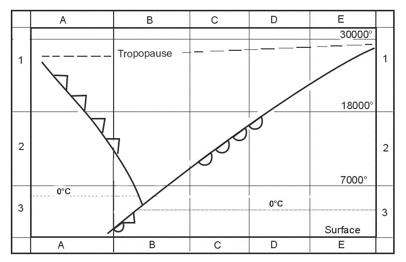
Question 101-28 : How does the tas value change with increases in altitude in the troposphere and tropopause for a constant mach speed ?
Tas decreases in the troposphere and stays the same in the tropopause.
Mach number = tas lss lss = 3895 kas you climb below the tropopause the temperature decreases as a result lss decreases to maintain a constant mach number tas must also decreaseas we've seen above the speed of sound depends only on air temperature not density so for a given temperature a given mach number will always equate to the same tas in other words for a given mach number tas remains constant throughout the constant temperature region above the tropopauseTas increases in the troposphere and is unchanged in the tropopause. tas decreases in the troposphere and increases in the tropopause. tas increases in both the troposphere and tropopause.
Question 101-29 : Which statement regarding gross performance is true ?
Actual flight performance with no safety factor.
Important note we believe this question to be very flawed and that there are no truly correct options all recent feedback points to actual flight performance with no safety factor as being correct in the exam but as per our explanation below the gross performance is not the actual flight performance instead it is the expected average fleet performanceit is possible that some authorities have picked up on this being incorrect so look out for the fixed question being present in your real exam which would have a correct answer of calculated performance with no safety factor or something with that meaning please let us know in the comments if you see any version of this question in your real exam and what you can remember from it thank you when aircraft are being certified the manufacturer must test the aircraft in many different ways to define certain levels of performance for many phases of flight such as take off distance maximum rate of climb landing distance and many morethere are different types of performance categorisationmeasured performance is the performance achieved by the manufacturer under test conditions for certification it utilises new aeroplanes and the test pilots and is therefore not representative of the actual performance that any single aircraft might be able to achieve in normal circumstances flown by a normal pilotgross performance is the expected fleet average of aeroplanes given that they are sufficiently maintained and flown as per the techniques detailed in the flight manuals by a normal pilot this means that any aircraft in the fleet has a 50% chance of exceeding this performance but also a 50% chance of not meeting this performancenet performance is the gross performance reduced by the safety margin to account for various possibilities that could commonly cause reduced performance such as variations in pilot technique below average aircraft performance etc the safety margin is set so that the chance of an aircraft not meeting the net performance level is extremely low the safety margin is not fixed it depends on the likelihood of the situation occurring and is set to make sure that the total probability of an incident or accident occurring is at least lower than 1 in 1 million when a passenger buys their ticket known as their remote probability this might mean that the safety margin between gross and net performance is large for likely events such as a take off with all engines operating but the safety margin is very low or even zero for unlikely events such as an engine failure at v1Calculated flight performance with a safety factor. margin between the net gradient and gross gradient. actual flight performance with a safety factor.
Question 101-30 : How does the outside air temperature and pressure altitude affect the approach and landing climb performance of an aeroplane ?
The worst performance will occur with a combination of high outside air temperature and high pressure altitude.
The density of air has significant effects on the aircraft’s performance as air becomes less dense it reduces • power because the engine takes in less air • thrust because the propeller is less efficient in thin air • lift because the thin air exerts less force on the airfoilsthe pressure of the atmosphere may vary with time but more importantly it varies with altitude and temperature increasing the temperature of a substance decreases its density thus performance decreases a high pressure altitude is also associated with a decreased density thus the performance is worst when at a high pressure altitude and in combination with a high outside air temperatureThe worst performance will occur with a combination of low outside air temperature and low pressure altitude. the best performance will occur when the outside air temperature is high and the pressure altitude is low. the best performance will occur when the outside air temperature is low and the pressure altitude is high.
Question 101-31 : Complete the following sentence consider two jet aircraft of the same type the take off mass of jet 1 is 75 000 kg and for jet 2 it is 67 000 kg jet 1 will have a 1 speed for best angle of climb and a 2 speed for best rate of climb ?
1 higher 2 higher.
Refer to figuresbest angle of climb speed vx is found at the maximum excess of thrust – in other words where the gap between the thrust available and thrust required drag curves is the greatest weight has a very pronounced effect on aircraft performance if weight is added to an aircraft it must fly at a higher aoa to maintain a given altitude and speed this increases the induced drag of the wings as well as the parasite drag of the aircraft increased drag means that additional thrust is needed to overcome it which in turn means that less reserve thrust is available for climbing this moves the total drag curve up but also to the right thrust required is increased and vx is a faster iasbest rate of climb speed vy is found at the maximum excess of power – in other words where the gap between the power available and power required curves is the greatest as weight increases the power required curve moves up and to the right as a result less excess power is available and therefore the rate of climb decreases however as you can see the speed for maximum excess power available is highersummary higher weight => decreased rate of climb => increased vy speed(1) lowerxsx (2) lower. (1) lowerxsx (2) higher. (1) higherxsx (2) lower.
Question 101-32 : Complete the following sentence a take off performance is calculated with the use of given conditions if subsequently the oat drops the aircraft's climb performance will 1 because the excess thrust will be 2 ?
1 improve 2 increased.
Climb performance is a measure of excess thrust which generally increases lift to overcome other forces such as weight and drag since weight altitude and configuration changes affect excess thrust and power they also affect climb performanceone of the factors that affect the climb performance is the air density air density affects the mass flow of air into the engine an increase in air density increases thrust available as a result the difference between thrust and drag will be greater therefore the climb performance of an aircraft increases in those circumstances(1) improvexsx (2) reduced. (1) deterioratexsx (2) increased. (1) deterioratexsx (2) reduced.
Question 101-33 : A jet aeroplane has three configurations available for take offto 1 1 stage of slats and flaps to 2 2 stages of slats and flaps to 3 3 stages of slats and 3 stages of flapsthe runway is not limiting but the given departure requires a climb gradient of 68% to 2 000 ft which to configuration will be ?
To 1 because it results in greater climb speeds and greater rate of climb than when using to2.
Effect of flaps on landingtake off run and climb gradientthe use of high lift devices flaps will have an impact on the take off and landing roll and climb gradientfor a given runway length and airplane weight selecting a greater flap setting will increase the lift coefficient which reduces the stalling speed as a consequence the take off speeds are reduced the same lift will be created at smaller air speed due to greater lift coefficient this will reduce the take off run flap extension during landings provides several advantages by producing greater lift and permitting lower landing speedproducing greater drag permitting a steep descent angle without airspeed increase=> reducing the length of the landing rollthe down side of the use of flaps is that it generates more parasite drag we get our best angle of climb and therefore our best gradient where there is the biggest gap between the thrust available and thrust required the parasite drag from the extended flap closes the gap and the climb angle and climb gradient will reduce => go around performance is deteriorated hence as soon as we can after take off we accelerate and retract the flap and climb clean thus we can conclude that the best climb gradient will be achieved using the least amount of flapsT/o 3 because it results in greater climb speeds and greater rate of climb than when using t/o1. t/o 2 because it results in lower climb speeds and greater rate of climb than when using t/o3. t/o 1 because it results in lower climb speeds, giving a higher angle of climb than when using t/o2.
Question 101-34 : Complete the following sentence the maximum achievable straight and level flight ias of a piston engined aeroplane ?
Decrease with altitude.
The maximum achievable speed vmax whether measured as a tas or ias is where thrust equals drag with an increasing altitude the air becomes less dense consequently the thrust available reduces thus vmax decreasesIncrease with altitude. increase until transition altitude and remains constant thereafter. decrease until transition altitude and remains constant thereafter.
Question 101-35 : What is the effect on a take off distance if both the aerodrome pressure altitude and the aerodrome temperature increase ?
Take off distance will increase.
Air densityas air density decreases altitude andor temperature increases both engine and aerodynamic performance decrease aircraft performance depends on air density which directly affects lift and drag engine power and propeller efficiency take off distance when an aircraft is taking off at a pressure altitude above isa sea level it will still get airborne at the same indicated airspeed ias as at sea level but because of the lower air density the true airspeed tas will be greater to achieve this higher speed with the same engine power a longer take off run will be neededTake off distance remains about the same because the increase in temperature cancels out the effect of the increase in pressure altitude. take off distance will increase by a small amount because the increase in pressure altitude reduces the effects of the increase in temperature. take off available will increase.
Question 101-36 : To maximise the specific range of an aeroplane ?
True airspeed must be high and the fuel flow must be low.
Specific range sr is a measure of range capability expressed as the air distance nam travelled per unit of fuel consumed or as tas divided by fuel flow a high specific range equals a good range capabilityspecific range = tasfuel flow = air distancekg of fuel to maximise the specific range of an aeroplane the ratio of tas by fuel flow must be increased true airspeed must be high and the fuel flow must be lowTrue airspeed must be low, and the fuel flow must be high. true airspeed must be high, and the fuel flow must be high. true airspeed must be low, and the fuel flow must be low.
Question 101-37 : Determine the one engine out climb gradient of a four engined aeroplane given aeroplane mass 315 000 kgthrust per engine 245 000 ndrag 435 000 n assume the acceleration due to gravity is 10 ms2 ?
95%.
Thrust t = number of engines 4 1 inop x thrust per enginet = 3 x 245 000 n = 735 000 nweight w = aeroplane mass x 10 ms2w = 315 000 kg x 10 ms2 = 3 150 000 nclimb gradient = thrust drag weight x 100%climb gradient = 735 000 435 000 3 150 000 x 100% = 95%8% 8.5% 9%
Question 101-38 : Which of the following statements is correct in relation to a turbojet engine's specific fuel consumption sfc ?
Sfc decreases at higher altitudes and colder ambient temperatures.
Specific fuel consumptionspecific fuel consumption sfc in a jet is the fuel flow per unit of thrust while sfc for a propeller is the fuel flow per unit of power it is a measurement of efficiency lower sfc means less fuel used so is better it is also an engine measurement not to do with the aircraft's aerodynamicsin a turbojet engine sfc is lowest which is best when the air temperature is low and also when the engine is running at its design rpm of approximately 90 to 95% rpm this means that sfc is proportional to temperatureit also means that the engine aircraft combination is most efficient at high altitude where the thrust required to overcome drag is approximately 90 to 95% of the thrust available this creates an optimum altitude for a turbojet engine where the most efficient engine speed lines up with the most efficient airframe speed this is an aerodynamic consideration though and is not actually about the sfcthis then gets a little complex as sfc being engine dictated not aerodynamic is not actually to do with the pressure of the air pressure altitude but actually changes based on the temperature of the air colder air being more efficient to burn therefore lower sfc the problem with this is that the pressure altitude usually dictates the temperature higher altitude = colder temperatures = lower sfcthis means that we are going to have to discount the answer that states altitude has no effect on sfc because it does affect it just via the changing temperatures the answer doesn't leave any wiggle room to argue its case so we cannot declare it truetherefore we have to choose the answer stating sfc decreases at higher altitudes and cold ambient temperatures because this effectively goes through our own thought process of working out sfc higher altitude = colder temperature = lower sfcTemperature has no effect on sfc. sfc decreases at lower altitudes and warmer ambient temperatures. altitude has no effect on sfc.
Question 101-39 : The speed to obtain the maximum specific range sr of a turbojet aeroplane is… ?
132 x minimum drag vmd speed.
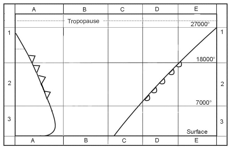
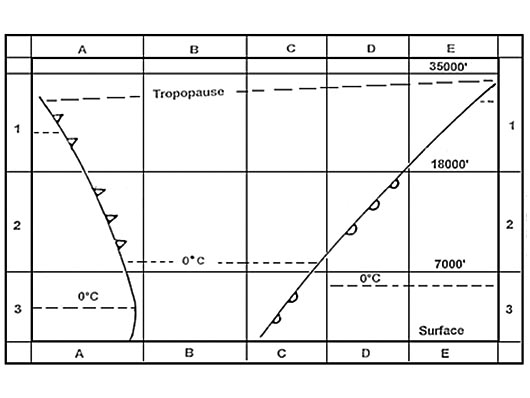
Refer to figuresdragthrust required curve•lowest point of curve – vmd best ld ratio and best glide=> for jet vx = maximum endurance speed=> for prop maximum range speed•tangent – 132 vmd=> for jet best range speed and vythe tangent of the drag graph gives the point at which the speed to drag ratio is highest meaning we get the best deal of speed vs drag this is the speed we fly to get the best range and also is very close to the speed for best rate of climb due to similar reasonsMaximum lift / drag (l/d) ratio speed. minimum drag (vmd) speed. minimum power (vmp) speed.
Question 101-40 : Delays are expected at the arrival aerodrome at which a jet transport aeroplane plans to land by managing the en route airspeed the pilot can increase the flight endurance by flying at… ?
Minimum drag speed vmd at clean configuration which corresponds to the minimum required total thrust.
Refer to figures in order to maintain best endurance speed in a jet aircraft we want to use as little thrust as possible for the lowest fuel burn whilst maintaining the same amount of lift this means we have to reduce drag the opposing force of thrust to its minimal possible value this means flying at the speed which corresponds to minimum drag vmdin a jet aircraft vmd gives us the best endurance and best angle of climb vx when flaps are put down this does not affect our induced drag as our lift value remains the same equal to our weight it does increase our parasite drag though by presenting a larger surface to the airflow and therefore increases our overall drag this means that more thrust is required with flaps out and therefore we will burn fuel faster as well as flying slower due to lower vmd speed in a dirty configurationthis means that best endurance occurs at vmd in the clean configurationMinimum drag speed (vmd) at an intermediate flap configuration, due to the lower vmd speed value. long range cruise speed (lrc), at an intermediate flap configuration, due to the lower lrc speed value. long range cruise speed (lrc), at clean configuration, which corresponds to the minimum required total thrust.
Exclusive rights reserved. Reproduction prohibited under penalty of prosecution.