A free Premium account on the FCL.055 website! Read here
Sign up to unlock all our services and 15164 corrected and explained questions.
Question 119-1 : If cas is 190 ktsaltitude 9000 fttemp isa 10°ctrue course tc 350°wv 32040distance from departure to destination is 350 nmendurance 3 hoursand actual time of departure is 1105 utcthe point of equal time pet is reached at ? [ Training professional ]
1213 utc
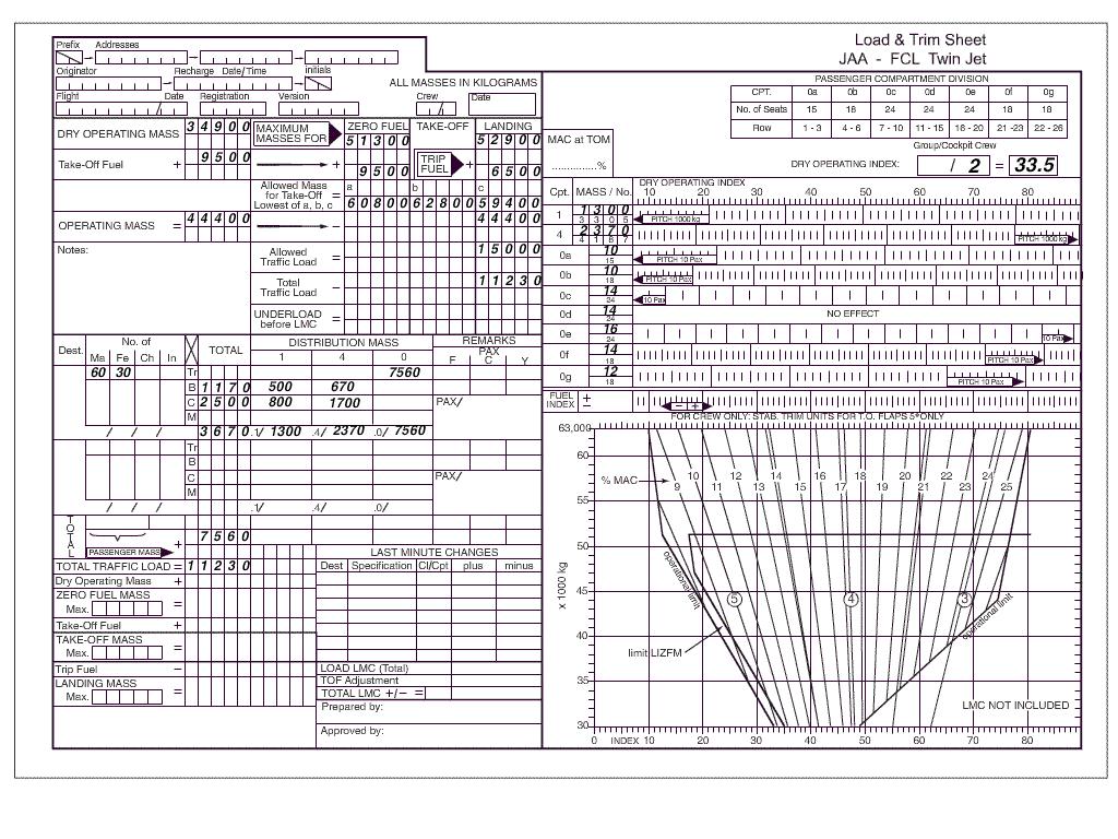
Question 119-2 : At reference or see flight planning manual mrjt 1 figure 44planning a flight from paris charles de gaulle to london heathrow for a twin jet aeroplanepreplanning dry operating mass dom 34 000 kgtraffic load 13 000 kgthe holding is planned at 1 500 ft above alternate elevation the alternate elevation ?
48 125 kg.
Landing mass at alternate = dry operating mass + traffic load + final reserve fuelnotice you must land at destination or alternate when pre planning with final reserve fuel in your tanks com encom033 129jpg34000+13000 = 47000 kginterpolate from the table 2280 + 2220 2 = 2250 kghfor 30 minutes = 1125 kg47000 + 1125 = 48125 kg2 250 kg. 48 675 kg. 49 250 kg.
Question 119-3 : Given distance from departure to destination 1385 nm gs out 480 kt gs home 360 kt what is the time of the pet from the departure point ?
74 min.
Ground speed out = 480 ktground speed home = 360 ktpet = distance x gsh gso + gsh pet = 1385 x 360 480 + 360 pet = 498600 840 = 593 nmtime of the pet from the departure point 593 480 = 123 h123 x 60 = 74 minutes128 min. 96 min. 50 min.
Question 119-4 : Given distance from departure to destination 256 nm gs out 160 kt gs home 110 kt what is the distance of the pet from the departure point ?
104 nm.
Ground speed out gso = 160 ktground speed home gsh = 110 ktdistance to pet = distance x gsh gso + gsh distance to pet = 256 x 110 160 + 110 distance to pet = 28160 270 = 104 nm 152 nm. 128 nm. 176 nm.
Question 119-5 : Given distance from departure to destination 480 nmsafe endurance 5 htrue track 315°wv 10020tas 115 ktwhat is the distance of the psr from the departure point ?
280 nm.
Start by searching outbound ground speed on nav computer set 115 kt under center dot true track 315° to true index put wind direction 100° under the red compass rose under 20 kt you read a left drift of 4° now drift is always measured from heading to track turn to set true heading 319° 315° + 4° left drift under index you now read your ground speed out of 130 ktrepeat the operation to find homeward ground speedoutbound gs 130 kthomeward gs 99 ktpoint of safe return psr = endurance x homeward gs outbound gs + homeward gs point of safe return psr = 5 x 99 130 + 99 point of safe return psr = 495 229point of safe return psr = 216 h016 x 60 = 10 minutes10 + 120 minutes = 130 mindistance of the psr from the departure point at a speed of 132 kt 130 min x 13060 = 2816 nm205 nm. 141 nm. 199 nm.
Question 119-6 : Given distance from departure to destination 150 nm true track 142°wind 200°15kt tas 132 kt what is the distance of the pet from the departure point ?
79 nm.
Under index set true track 142° centre dot on tas 132 kt with the rotative scale set wind 200°15 kt you find a left drift of 5°now drift is always measured from heading to track turn to set true heading 147° 142° + 5° left drift under index you now read your ground speed out of 124 kt com encom033 142jpgproceed in the same way to find the ground speed home of 139 kt right drift of 5° true heading of 317° ground speed out gso = 124 ktground speed home gsh = 139 ktdistance to pet = distance x gsh gso + gsh distance to pet = 150 x 139 124 + 139 distance to pet = 20850 263 = 792 nm 71 nm 75 nm 134 nm
Question 119-7 : A metar reads 1430z 35002kt 7000 skc 2103 q1024 =which of the following information is contained in this metar ?
Temperaturedewpoint.
1430 = time 1430 utc 35002kt = wind 350°02 kt7000 = visibility 7000 metersskc = sky clear 2103 = temperaturedewpoint q1024 = qnh 1024 hpaRunway in use. day/month. period of validity.
Question 119-8 : The wind °kt at 40°n 020°w is err a 033 157 ?
Question 119-9 : Given maximum allowable take off mass 64 400 kgmaximum landing mass 56200 kgmaximum zero fuel mass 53 000 kgdry operating mass 35 500 kgestimated load 14 500 kgestimated trip fuel 4 900 kgminimum take off fuel 7 400 kgfind maximum additional load ?
3 000 kg.
com encom033 162jpgwe are able to add 3000 kg beore reaching our first limitation which comes from the maximum zero fuel mass 17500 14500 = 3000 kg7 000 kg. 5 600 kg. 4 000 kg.
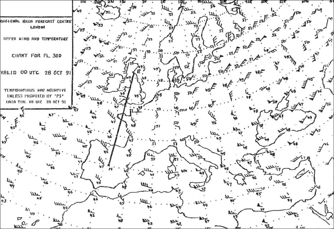
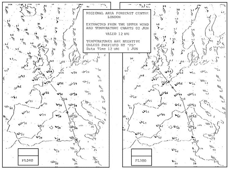
Question 119-10 : What mean temperature °c is likely on a course of 360° t from 40°n to 50°n at 040°e err a 033 167 ?
Mean temperature 47°c.
com encom033 167jpgtemperatures are negative unless prefixed by ps 46 + 47 + 47 + 48 + 49 5 = 474°cMean temperature : -46°c. mean temperature : -49°c. mean temperature : -50°c.
Question 119-11 : For flight planning purposes the landing mass at alternate is taken as ?
Zero fuel mass plus final reserve fuel and contingency fuel.
Planned landing mass at alternate = dom + traffic load + final reserve fuel + contingencyif everything goes to plan on the sector you won't use contingency fuel so landing mass at alternate will include final reserve fuel + contingency fuelLanding mass at destination plus alternate fuel. zero fuel mass plus final reserve fuel and alternate fuel. zero fuel mass plus final reserve fuel.
Question 119-12 : Given distance from departure to destination 220 nmtrue track 175°wind 22010 kttas 135 ktwhat is the distance of the pet from the departure point ?
116 nm.
Under index set true track 175° centre dot on tas 135 kt with the rotative scale set wind 220°10 kt you find a left drift of 7°now drift is always measured from heading to track turn to set true heading 182° 175° + 7° left drift under index you now read your ground speed out of 119 kt com encom033 169jpgproceed in the same way to find the ground speed home of 148 kt right drift of 5° true heading of 350° ground speed out gso = 119 ktground speed home gsh = 148 ktdistance to pet = distance x gsh gso + gsh distance to pet = 220 x 148 120 + 148 distance to pet = 32780 268 = 121 nm closest answer is 116 nm 103 nm 110 nm 136 nm
Question 119-13 : At references or see flight planning manual mrjt 1 figure 42 and figure 4532 given estimated take off mass 57000 kgground distance 150 nmtemperature isa 10°ccruise at 74 machfind cruise altitude and expected true air speed err a 033 178 ?
Question 119-14 : Given distance from departure to destination 950 nmgs out 275 kt gs home 225 ktwhat is the time of the pet from the departure point ?
93 min.
Distance to pet = distance x gsh gso + gsh distance to pet = 950 x 225 275 + 225 distance to pet = 213750 500 = 4275 nmtime of the pet from the departure point 4275 nm 275 = 155 h155 x 60 min = 93 minutes139 min. 114 min. 39 min.
Question 119-15 : Given distance from departure to destination 950 nm safe endurance 35 h tas 360 kt ground speed out 320 kt ground speed home 400 kt what is the distance and time of the psr from the departure point ?
Distance 622 nm time 117 min.
Distance: 528 nm time: 79 min distance: 311 nm time: 52 min distance: 328 nm time: 62 min
Question 119-16 : Given distance from departure to destination 1000 nm safe endurance 4 h tas 500 kt ground speed out 550 kt ground speed home 450 kt what is the distance of the psr from the departure point ?
990 nm.
Ground speed out 550 ktground speed home 450 ktpoint of safe return psr = endurance x homeward gs outbound gs + homeward gs point of safe return psr = 4 x 450 550 + 450 point of safe return psr = 1800 1000point of safe return psr = 18 h08 x 60 = 48 minutes48 + 60 minutes = 108 mindistance of the psr from the departure point at a speed of 550 kt 108 min x 55060 = 990 nm450 nm. 495 nm. 10 nm.
Question 119-17 : Given distance from departure to destination 2200 nmtrue track 150°wind 330°50 kttas 460 ktwhat is the distance and time of the pet from the departure point ?
Distance 980 nm time 115 min.
Track 150° wind from 330° it's a tailwind of 50 kt ground speed out gso = 460 + 50 = 510 ktreturn track 330° wind from 330° it's a headwind of 50 kt ground speed home gsh = 460 50 = 410 ktdistance to pet = distance x gsh gso + gsh distance to pet = 2200 x 410 510 + 410 distance to pet = 902000 920 = 980 nm time of the pet from the departure point 980 nm 510 = 192 h192 x 60 min = 115 minutes Distance: 1120 nm time: 179 min distance: 1100 nm time: 179 min distance: 980 nm time: 144 min
Question 119-18 : Route manual chart napthe initial true course from a 64°n006°e to c 62°n020°w is err a 033 202 ?
271°.
com encom033 202jpgput your protractor on a align it with the true north you find an initial true course of 271°departure is almost superposed on the 64° parallel maercin i couldn't found those points on the map because there is written that a is on 006e so its impossible to find in this mapnevertheless you may also substract 64 62 = 2 degresses so if we multiply it by 60nm there is 120nm in vertical range if we use formula for distance = 60nm x cos mean longitude x g difference in latitude we have 708nm so now we take usual calculator input arc tg from 120708 = 9 deg and we know that track from a to b is 270 9 = 261after that we count convertion angle = 12 x sin mean latitude x difference in latitude and its equal to 10so we add 10 to 261 and here it is 271 i know that this is a little bit more difficult than reading from the map but on the other hand if you wasn't passed gen nav and flight planning its possible to resolve all maps questions without even look on them259°. 247°. 279°.
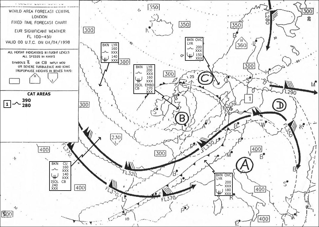
Question 119-19 : Which best describes the maximum intensity of icing if any at fl160 in the vicinity of berlin 53° n013°e err a 033 204 ?
Moderate.
629Severe. light. nil.
Question 119-20 : At reference or see flight planning manual sep 1 figure 21 given fl 75oat +5°cduring climb average head wind component 20 kttake off from msl with the initial mass of 3650 lbs find still air distance nam and ground distance nm using the graph 'time fuel distance to climb' err a 033 212 ?
18 nam 15 nm.
com encom033 212jpgtime to climb 9 minutesdistance to climb 18 namwith a headwind ground distance to climb will be lower than air distance to climb to fl75during 9 minutes 20 kt of wind will reduce our ground distance by 20 kt x 960 = 3 nm18 nam 3 nm = 15 nm14 nam. 18 nm. 16 nam. 18 nm. 18 nam. 13 nm.
Question 119-21 : Given distance from departure to destination 285 nm true track 348°wind 280°25 kttas 128 ktwhat is the distance of the pet from the departure point ?
154 nm.
Img com encom033 213ajpg com encom033 213bjpgground speed out = 117 ktproceed the same way to find ground speed home 136 kt distance to pet = d x gsh gso + gsh distance to pet = 285 x 136 117 + 136 distance to pet = 38760 253 = 1532 nm131 nm. 143 nm. 123 nm.
Question 119-22 : Given distance from departure to destination 435 nm gs out 110 kt gs home 130 kt what is the distance of the pet from the departure point ?
236 nm.
199 nm 218 nm 368 nm
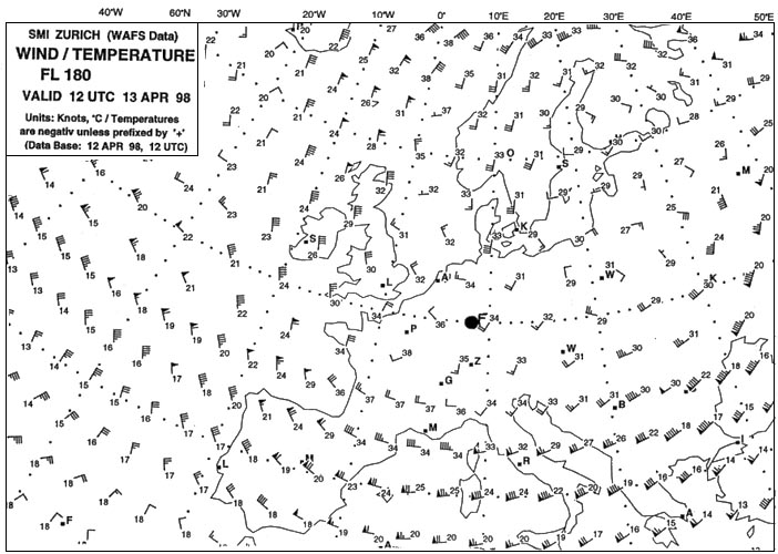
Question 119-23 : The approximate mean wind component kt along true course 180° from 50°n to 40°n at 005° w is err a 033 225 ?
Tail wind 55 kt.
com encom033 225jpgwind is coming from 320° with an average speed of 70 kttailwind component = 70 kt x cos angle between the wind and the course tailwind component = 70 kt x cos 40°tailwind = 54 ktTail wind 40 kt. tail wind 70 kt. headwind 55 kt.
Question 119-24 : The wind direction and velocity °kt at 40°n 040°e is err a 033 233 ?
33075.
Img com encom033 233jpgwind is coming from 330° with a speed of 75 kt330/85. 150/75. 300/75.
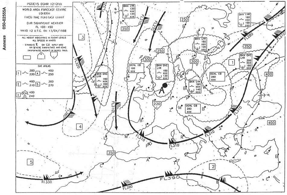
Question 119-25 : In the vicinity of shannon 52° n009°w the tropopause is at about err a 033 236 ?
Fl 360.
com encom033 236jpgFl 350. fl 300. fl 270.
Question 119-26 : At reference or see flight planning manual mrjt 1 figure 451given brake release mass 57 500 kg temperature isa 10°chead wind component 16 ktinitial fl 280find still air distance nam and ground distance nm for the climb err a 033 237 ?
62 nam 59 nm.
com encom033 237jpgwe are just below 58000 kg thus 62 nam is a good choicewith a headwind component our ground distance will be less than our air distance 59 nm sounds good59 nam, 62 nm. 67 nam, 71 nm. 71 nam, 67 nm.
Question 119-27 : Route manual chart napthe average magnetic course from c 62°n020°w to b 58°n004°e is err a 033 240 ?
119°.
To find the average magnetic course from c to b with a protractor between the two points you will find an average true track of 109° then you must add the 10°w magnetic variation we have right in the middle of those two points109° + 10° = 119° gomis01 in a past question asks the true course from c to b and the answer was 098º if right now asks about the magnetic course i am agree about the variation but i think that it will be 098+10 variation = 108ºthe answer more near is 109º please tell me if i wrong thank youthe other question asks for the initial true course from c to b not the average true course109°. 099°. 118°.
Question 119-28 : Given distance from departure to destination 360 nm safe endurance 45 h true track 345°wv 26030 tas 140 ktwhat is the distance of the psr from the departure point ?
308 nm.
Under index set true track 345° centre dot on tas 140 kt with the rotative scale set wind 260°30 kt you find a right drift of 12°now drift is always measured from heading to track turn to set true heading 333° 345° 12° right drift under index you now read your ground speed out of 135 ktproceed in the same way to find the ground speed home of 141 kt left drift of 9° true heading of 174° ground speed out gso = 135 ktground speed home gsh = 141 ktapply the psr formula psr = time x gs out x gs home gs out + gs home psr = 45 x 135 x 141 135 + 141 psr = 310 nmthis is a 4 points question at the exammathematical calculation on this kind of exercise is valid only for one right angled triangle which is not the case here only the computer enables you to find the good answer185 nm 154 nm 52 nm
Question 119-29 : What mean temperature °c is likely on a true course of 270° from 025°e to 010°e at 45°n err a 033 246 ?
Mean temperature is 50°c.
com encom033 246jpgtemperatures are negative unless prefixed by ps 53 + 51 + 50 + 47 4 = 5025°cMean temperature is -48°c. mean temperature is -52°c. mean temperature is -54°c.
Question 119-30 : At reference or see flight planning manual mrjt 1 figure 433c given ground distance to destination aerodrome 1600 nm headwind component 50 ktfl 330cruise speed 078 mach isa + 20°c estimated landing weight 55000 kg find simplified flight planning to determine estimated trip fuel and trip time err a ?
12 400 kg 03h 55 min.
Explanation com encom033 1017jpg12 400 kg, 04h 12 min. 11 400 kg, 03h 55 min. 11 400 kg, 04h 12 min.
Question 119-31 : Given distance from departure to destination 260 nm safe endurance 41 h true track 150°wv 10030 tas 110 ktwhat is the distance of the psr from the departure point ?
213 nm.
Under index set true track 150° centre dot on tas 110 kt with the rotative scale set wind 100°30 kt you find a right drift of 9°now drift is always measured from heading to track turn to set true heading 141° 150° 9° right drift under index you now read your ground speed out of 90 ktproceed in the same way to find the ground speed home of 127 kt left drift of 10° true heading of 340° ground speed out gso = 90 ktground speed home gsh = 127 ktapply the psr formula psr = time x gs out x gs home gs out + gs home psr = 41 x 90 x 127 90 + 127 psr = 215 nmthis is a 4 points question at the exammathematical calculation on this kind of exercise is valid only for one right angled triangle which is not the case here only the computer enables you to find the good answer154 nm. 107 nm. 47 nm.
Question 119-32 : Route manual chart nap the average true course from c 62°n020°w to b 58°n004°e is err a 033 262 ?
109°.
com encom033 262jpgwe are looking for average true course with you protractor aligned on true north between c and b you will find a true course of 109°119°. 099°. 120°.
Question 119-33 : Given distance from departure to destination 2450 nm safe endurance 75 h tas 410 kt ground speed out 360 kt ground speed home 460 kt what is the time of the psr from the departure point ?
252 min.
Point of safe return psr = endurance x homeward gs outbound gs + homeward gs ground speed out = 360 ktground speed home = 460 ktpoint of safe return psr = 75 x 460 360 + 460 point of safe return psr = 3450 820point of safe return psr = 420 h420 x 60 = 252 minutes198 min 111 min 156 min
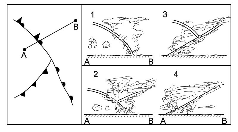
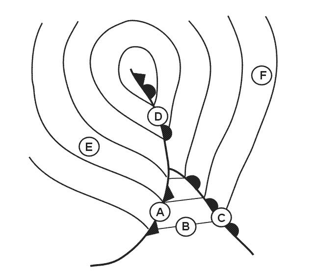
Question 119-34 : Which describes the worst hazard if any that could be associated with the type of feature at 38°n 015°e 2240 ?
Engine flame out and windscreen damage.
At 38°n 015°e we have the etna volcano 1242 read the story of british airways flight nine you will find and understand the answer on 24 june 1982 a 747 flew into a cloud of volcanic ash thrown up by the eruption of mount galunggung south east of jakarta indonesia resulting in the failure of all four enginesat approximately 13 42 utc 20 42 jakarta time engine number four began surging and soon flamed out the flight crew immediately performed the engine shutdown drill quickly cutting off fuel supply and arming the fire extinguishers less than a minute later at 13 43 utc 20 43 jakarta time engine two surged and flamed out within seconds and almost simultaneously engines one and three flamed out prompting the flight engineer to exclaim 'i don't believe it all four engines have failed 'the flight crew quickly determined that the aircraft was capable of gliding for 23 minutes and covering 91 nautical miles 169 km from its flight level of 37000 feetat 13 44 utc 20 44 jakarta time the senior first officer declared an emergency to the local air traffic control authority stating that all four engines had failed however jakarta area control misunderstood the message interpreting the call as meaning that only engine number four had shut down it was only after a nearby garuda indonesia flight relayed the message to air traffic control that it was understood despite the crew 'squawking' the emergency transponder setting of 7700 the aeroplane could not be located by air traffic control on their radar screensdue to the high indonesian mountains on the south coast of the island of java an altitude of at least 11500 feet was required to cross the coast safely the crew decided that if the aircraft was unable to maintain altitude by the time they reached 12000 feet they would turn back out to sea and attempt to ditch into the indian ocean the crew began the engine restart drills despite being well above the recommended maximum engine in flight start envelope altitude of 28000 feet the attempts failedat 13500 feet they were approaching the altitude at which they would have to turn over the ocean and attempt a risky ditching although there were guidelines for the procedure no one had ever tried it in a boeing 747 nor has anyone since as they performed the engine restart procedure engine number four started and at 13 56 utc 20 56 jakarta time the captain used its power to reduce the rate of descent shortly thereafter engine three restarted allowing him to climb slowly shortly after that engines one and two successfully restarted as wellthe crew subsequently requested and expedited an increase in altitude to 11500 feet in order to clear the high mountains of indonesia as flight 9 approached jakarta the crew found it difficult to see anything through the windscreen and had to make the approach almost entirely on instruments despite reports of good visibilityalthough the runway lights could be made out through a small strip of the windscreen the landing lights on the aircraft seemed to be inoperable after landing the flight crew found it impossible to taxi due to glare from apron floodlights which made the already sandblasted windscreen opaque aftermath it was found that the b747's problems had been caused by flying through a cloud of volcanic ash from the eruption of mount galunggung because the ash cloud was dry it did not show up on the weather radar which is designed to detect the moisture in clouds the cloud sandblasted the windscreen and landing light covers and clogged the engines as the ash entered the engines it melted in the combustion chambers and adhered to the inside of the power plant as the engine cooled from not running and as the aircraft descended out of the ash cloud the molten ash solidified and enough broke off to allow air to flow smoothly through the engine allowing a successful restart the engines had enough electrical power to restart because one generator and the onboard batteries were still operatingSevere attenuation in the hf r/t band. reduced visibility. there is no hazard.
Question 119-35 : Route manual chart napthe distance nm from c 62°n020°w to b 58°n004°e is err a 033 266 ?
760 nm.
Report the track distance along latitude 60°n average latitude between a and c you will count a little bit more of 25° separation between a and c25° x 60 nm x cos 60° = 750 nm com encom033 266jpgyou can also use meridian 1° = 60 nmtake care if you simply calculate latitude distance between 020°w and 004°e you will have 24° of latitude but points are not on the same longitude this is the reason that we need to report the track distance along latitude 60°n you will now count 25° of latitude on the mid latitude725 nm. 700 nm. 775 nm.
Question 119-36 : The planned flight is over a distance of 440 nmbased on the wind charts at altitude the following components are foundfl50 30ktfl100 50ktfl180 70ktthe operations manual in appendix details the aircraft's performanceswhich of the following flight levels fl gives the best range performance err a ?
Fl 180.
You have to extrapolate data fl50 tas= 194kt ho y fuel flow= 206 lhr gs= 164kt flight time= 26h fuel burn= 552 lfl100 tas= 200kt ho y fuel flow= 192 lhr gs= 150kt flight time= 29h fuel burn= 5632 lfl180 tas= 216kt ho y fuel flow= 163 lhr gs= 146kt flight time= 301h fuel burn= 491 lflight level 180 gives the best range performance lowest comsumption Fl 100. fl 050. either fl 050 or fl 100.
Question 119-37 : At reference or see flight planning manual mrjt 1 figure 435for a flight of 2800 ground nautical miles the following apply head wind component 20 kttemperature isa +15°cbrake release mass 64700 kgthe a trip fuel and b trip time respectively are err a 033 268 ?
A 17000 kg b 6h 45 min.
com encom033 268jpgyou always need to go first to the ref line and then apply the condition mass temperature wind (a) 15800 kg (b) 6h 15 min (a) 16200 kg (b) 6h 20 min (a) 18400 kg (b) 7h 00 min
Question 119-38 : Given distance from departure to destination 1950 nm gs out 400 kt gs home 300 kt what is the time of the pet from the departure point ?
125 min.
Pet = distance x gsh gso+ gsh pet = 1950 x 300 400 + 300 pet = 585000 700 = 835 nm835 nm 400 = 209 h 2 hour 05 minutes = 125 minutes 223 min 167 min 29 min
Question 119-39 : Given distance from departure to destination 95 nm true track 105 wind 06015 tas 140 kt what is the distance of the pet from the departure point ?
51 nm.
47,5 nm. 82 nm. 44 nm.
Question 119-40 : Given distance from departure to destination 150 nmtrue track 020°wind 18030tas 130 ktwhat is the distance of the pet from the departure point ?
59 nm.
Find the wind correction angle and the ground speed on the computer computer solution a set true track to true indexb turn the indicator to the wind direction in this case using the black azeimuth graduation the angle being upwind counting anti clockwise c shift the speed arc corresponding to the true air speed so as to coincide with the wind speed on the indicatord read the wind correction at the same place read the ground speed under the center bore from the scale on the axis slidegs out = 157 ktgs home = 102 ktdistance to pet = d x h o + h distance to pet = 150 x 102 157 + 102 = 59 nm75 nm. 91 nm. 65 nm.
~
Exclusive rights reserved. Reproduction prohibited under penalty of prosecution.