A free Premium account on the FCL.055 website! Read here
Sign up to unlock all our services and 15164 corrected and explained questions.
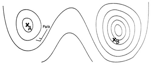
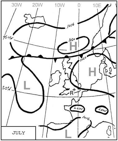
Question 120-1 : The surface wind velocity °kt at parischarles de gaulle at 1330 utc was err a 033 281 ? [ Preparation civilian ]
27004
Question 120-2 : From which of the following would you expect to find the dates and times when temporary danger areas are active ?
Notam and aip.
Only aip sigmet rad/nav charts
Question 120-3 : What is the earliest time utc if any that thunderstorms are forecast for tuniscarthage err a 033 284 ?
1800 utc.
If any the earliest time is 1800 utclong taf terminal area forecast released at 1020 utc specify a tempo from 1800 to 0200 next day with shra or tsshra com encom033 284jpg1300 utc. 0800 utc. nil.
Question 120-4 : A sector distance is 450 nm longthe tas is 460 kt the wind component is 50 kt tailwindwhat is the still air distance ?
406 nautical air miles nam.
With a tailwind of 50 kt your ground speed will be 460 kt + 50 kt = 510 kt450 nm at 510 kt = 450510 = 0882 hnautical air miles = 460 x 0882 = 406 namyou can use the following formula nam = ngm x tasgs nam = 450 x 460510 = 406 nam499 nautical air miles (nam) 414 nautical air miles (nam) 511 nautical air miles (nam)
Question 120-5 : Find the distance to the point of safe return psr given maximum useable fuel 15000 kgminimum reserve fuel 3500 kgoutbound tas 425 kthead wind component 30 ktfuel flow 2150 kghreturn tas 430 kttailwind component 20 ktfuel flow 2150 kgh ?
1125 nm.
Point of safe return psr = endurance x homeward gs outbound gs + homeward gs outbound gs = 425 30 = 395 kthomeward gs = 430 + 20 = 450 ktendurance = 15000 3500 2150 = 53488 hpoint of safe return psr = 53488 x 450 395 + 450 point of safe return psr = 53488 x 450 845point of safe return psr = 28484 h28484 h x 395 kt = 1125 nmwe are talking about a point of safe return a decision in case of our destination is finally unreachable weather issue for example and legally we need to return to our departure airport with our minimum reserve fuel1143 nm. 1463 nm. 1491 nm.
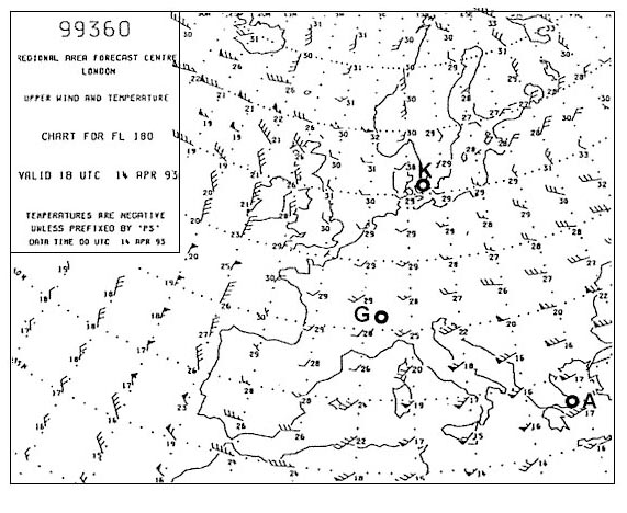
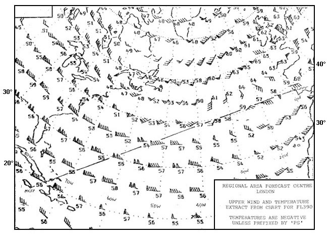
Question 120-6 : What is the temperature deviation °c from isa over 50° n 010°e err a 033 295 ?
Deviation is 10°.
At fl300 outside air temperature is 55°c com encom033 295jpgat fl300 standard temperature is 15°c 30 x 2°c = 45°cdeviation is 10°c isa 10°c Deviation is -55°. deviation is 2°. deviation is 10°.
Question 120-7 : Given distance from departure to destination 2000 nm safe endurance 5 h tas 500 kt ground speed out 480 kt ground speed home 520 kt what is the distance of the psr from the departure point ?
1248 nm.
1040 nm 624 nm 752 nm
Question 120-8 : At reference or see flight planning manual mrjt 1 figure 431cfor a flight of 1900 ground nautical miles the following apply head wind component 10 kttemperature isa 5°ctrip fuel available 15000 kglanding mass 50000kgwhat is the minimum cruise level pressure altitude which may be planned err a 033 ?
17000 ft.
com encom033 308jpgabove 'landing weight' on the right part of the graph you have to follow an imaginary line between the the dashed line and the continuous line continuous line is for a pressure altitude flight of 37000 ft dashed line is for pressure altitude flight of 10000 ft 22000 ft. 14000 ft. 10000 ft.
Question 120-9 : At reference or see flight planning manual mrjt 1 figure 44holding planningthe fuel required for 30 minutes holding in a racetrack pattern at pressure altitude 1500 ft mean gross mass 45 000 kg is err a 033 309 ?
1090 kg.
You have to interpolate com encom033 309jpg 2220 + 2140 2 = 2180 kg for one hour21802 = 1090 kg for 30 minutes1010 kg. 1310 kg. 2180 kg.
Question 120-10 : The wind °kt at 60° n015° w is err a 033 315 ?
30060.
com encom033 315jpg50 + 10 = 60 kt300/70. 320/60. 115/60.
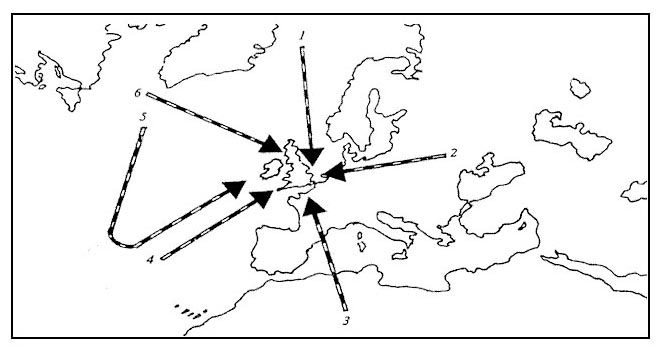
Question 120-11 : Route manual chart napthe initial true course from c 62°n020°w to b 58°n004°e is err a 033 319 ?
098°.
Img com encom033 319jpgtrue course 098°116°. 080°. 278°.
Question 120-12 : Find the distance from waypoint 3 wpt 3 to the critical pointgiven distance from wpt 3 to wpt 4 = 750 nmtas out 430 kttas return 425 kttailwind component out 30 kthead wind component return 40 kt ?
342 nm.
Ground speed out = 430 + 30 = 460 ktground speed home = 425 40 = 385 ktdistance to pet = d x gsh gso + gsh distance to pet = 750 x 385 460 + 385 distance to pet = 288750 845 = 3417 nm 375 nm. 408 nm. 403 nm.
Question 120-13 : At reference or see flight planning manual mrjt 1 figure 451given brake release mass 57500 kginitial fl 280average temperature during climb isa 10°caaverage head wind component 18 ktfind climb time for enroute climb 28074 err a 033 325 ?
13 minutes.
com encom033 356jpgat 57500 kg we are closer to 58000 kg than 56000 kg 13 minutes is our answer no need to interpolate11 minutes. 15 minutes. 14 minutes.
Question 120-14 : Given distance from departure to destination 180 nm true track 310wind 010°20 kttas 115 kt what is the distance of the pet from the departure point ?
98 nm.
Ducksherminator with my calculations using crp 5w i find gs o = 110ktsgs h = 120ktspet=dxh o+h =9391nm which is much closer to 92nm than 98nmyou need to be a little more accurate with the wiz wheelyou will get 104 kt for the outbound leg and 124 kt for the home legground speed out gso = 104 ktground speed home gsh = 124 ktdistance to pet = distance x gsh gso + gsh distance to pet = 180 x 124 104 + 124 distance to pet = 22320 228 = 9789 nm82 nm. 90 nm. 92 nm.
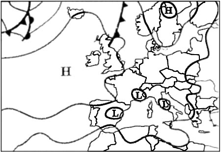
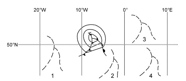
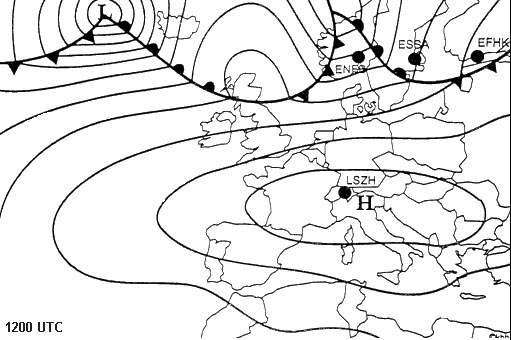
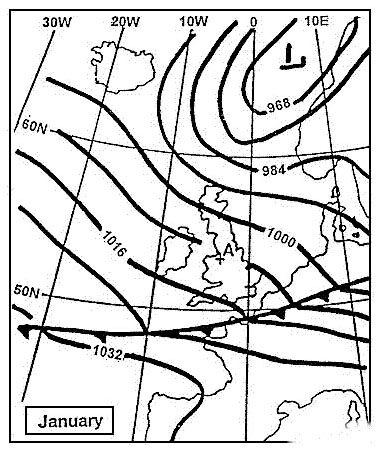
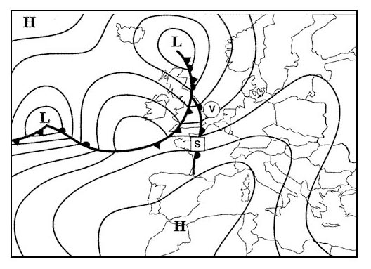
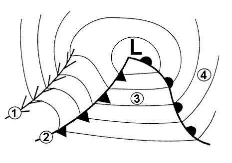
Question 120-15 : The surface system over vienna 48°n016°e is a err a 033 330 ?
Cold front moving east.
com encom033 330jpgcold front moving east at 10 kmhWarm front moving north. stationary occluded front. cold front moving west.
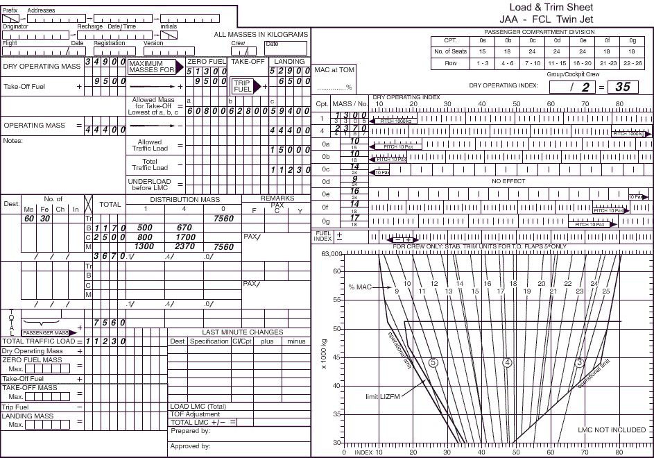
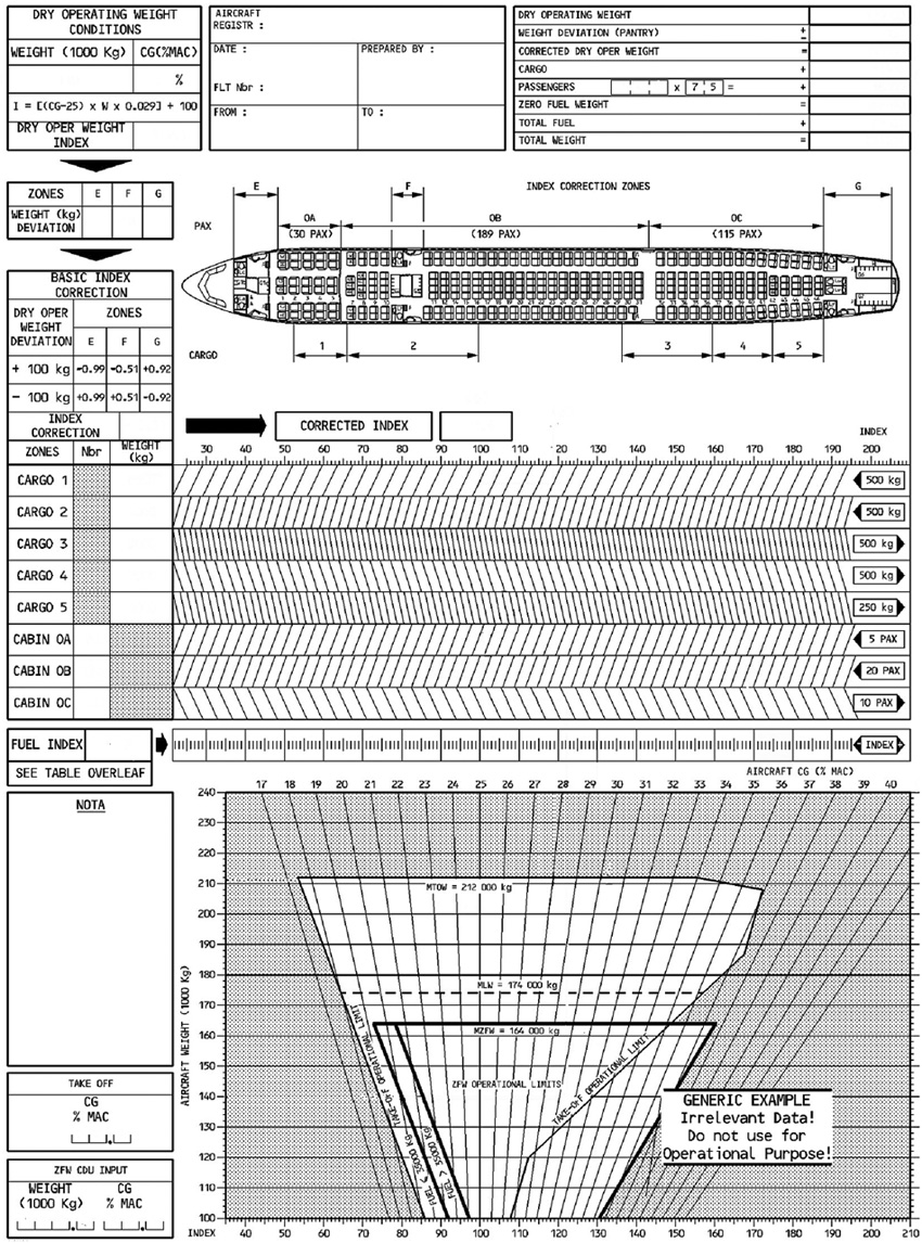
Question 120-16 : Given dry operating mass = 33510 kg traffic load= 7600 kgtrip fuel = 2040 kg final reserve fuel= 983 kg alternate fuel= 1100 kg contingency fuel= 5% of trip fuelwhich of the listed estimated masses is correct ?
Estimated landing mass at destination= 43295 kg.
Estimated take-off mass= 45233 kg. estimated landing mass at destination= 43193 kg. estimated take-off mass= 43295 kg.
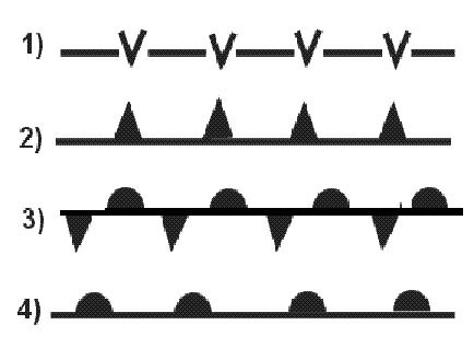
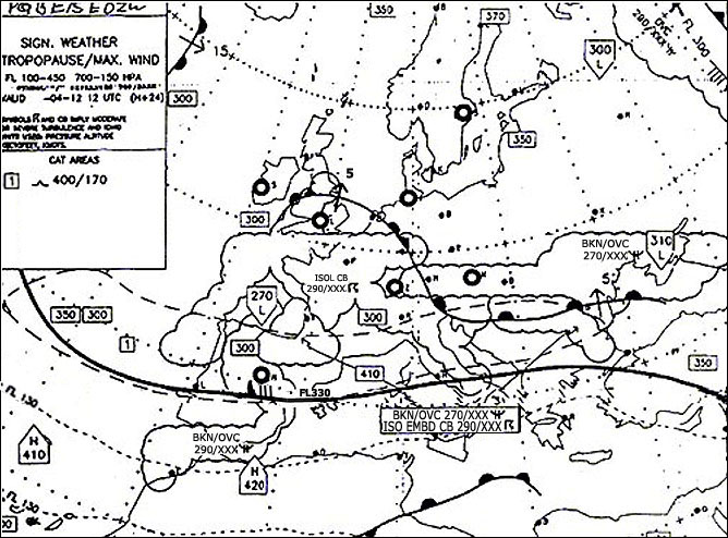
Question 120-17 : The lowest cloud conditions oktasft at bordeauxmerignac at 1330 utc were err a 033 340 ?
1 to 2 at 3000 ft.
com encom033 340jpgthe cloud cover classification is few 18 to 28 cloud coveragesct scattered 38 to 48 cloud coveragebkn broken 58 to 78 cloud coverageovc overcast 88030 means 3000 ft dizertie tempo indicate a could layer of scatered at 500ft do you see an answer 3 to 4 at 500 ft no and there is a reason tempo doesn't refer to the actual conditions the question asks for the actual conditions not the forecasted conditions1 to 4 at 3000 ft. 3 to 4 at 2000 ft. 3 to 4 at 800 ft.
Question 120-18 : At reference or see flight planning manual mrjt 1 figure 42 find the short distance cruise altitude for the twin jet aeroplane given brake release mass=45000 kgtemperature=isa + 20°ctrip distance=50 nautical air miles nam err a 033 343 ?
10000 ft.
11000 ft 7500 ft 12500 ft
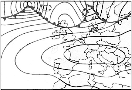
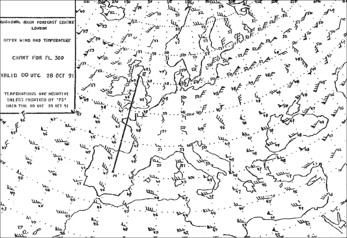
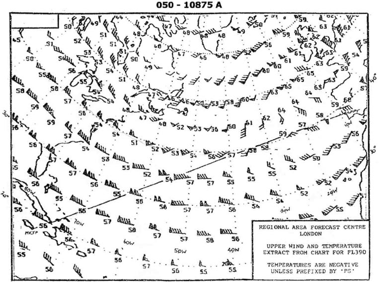
Question 120-19 : The maximum wind velocity °kt shown in the vicinity of munich 48°n 012°e is err a 033 346 ?
300140.
arrows feathers and pennants arrows indicate direction number or pennants andor feathers correspond to speedexample with a 270°115 kt wind com encom033 346ajpgpennants correspond to 50 ktfeathers correspond to 10 kthalf feathers correspond to 5 kt com encom033 346bjpgmunich is below the jet axis direction of the jet is 300° there is two pennants and four feathers so 140 ktthere is a decrease of speed after the two oblic lines highlighted in red 300/100 300/160 290/110
Question 120-20 : At references or see flight planning manual mrjt 1 paragraph 52 and figure 451 planning an ifr flight from paris to london for a twin jet aeroplanegiven estimated take off mass tom 52000 kgairport elevation 387 ftfl 280wv 280°40 ktisa deviation 10°caverage true course 340° find ground distance to ?
50 nm.
com encom033 347jpgtas 353 kt and air distance 53 nmon nav computer set under true index the true course 340° under the center dot tas 353 kt with the rotating scale set wind 280° and under the wind speed 40 kt you read a right drift of 6°it means that we need to fly on a true heading of 340° 6° = 334° to stay on the courseset 334° under true index you read a ground speed of 332 ktto determine the ground distance travelled in the climb multiply the air distance by the groundspeed and divide by the tas 53 x 332 353 = 4984 nm47 nm. 53 nm. 56 nm.
Question 120-21 : Flight planning manual mrjt 1 figure 451 planning an ifr flight from paris charles de gaulle to london heathrow for the twin jet aeroplane given estimated take off mass tom 52000 kgairport elevation 387 ftfl 280wv 280°40 ktisa deviation 10°caverage true course 340°find time to the top of climb toc ?
11 min.
15 min 3 min 12 min
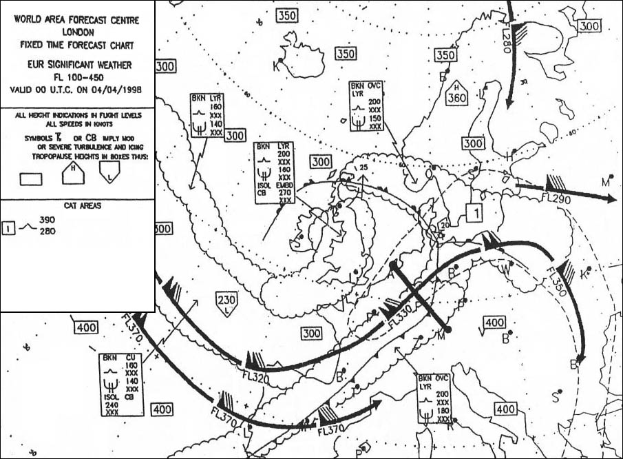
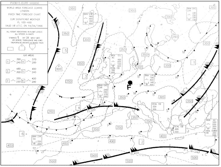
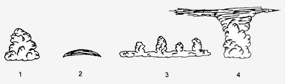
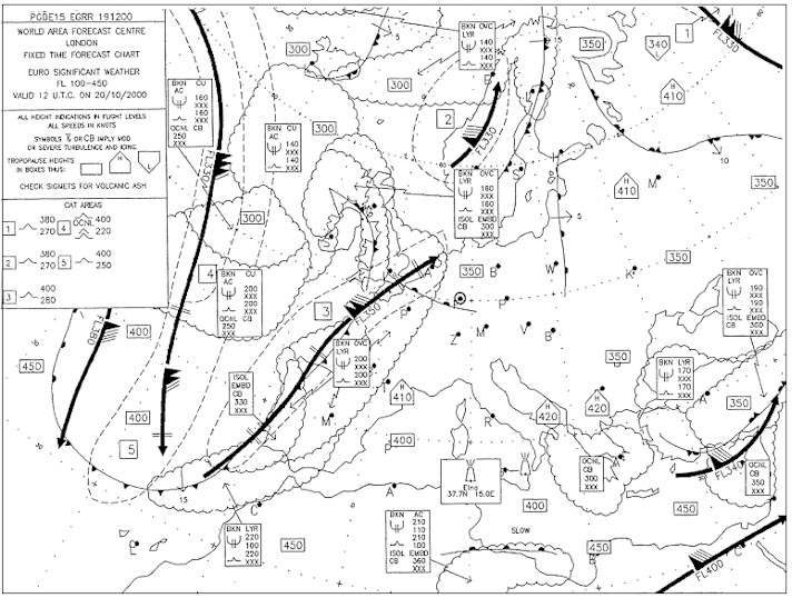
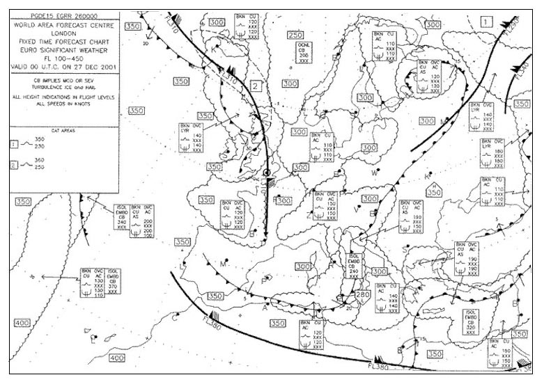
Question 120-22 : Which describes the maximum intensity of turbulence if any forecast for fl260 over toulouse 44°n001°e err a 033 350 ?
Severe.
This chart goes from fl100 up to fl450 embedded cumulonimbus clouds with base below fl100 and top up to fl270 are located in the area enclosed by scalloped lines over toulouse com encom033 350jpgeven though we are in cat n°1 aera showing moderate turbulence symbol isol emb cb isolated embedded cb always means moderate to severe turbulence thus the maximum intensity can be severeModerate. light. nil.
Question 120-23 : At reference or see flight planning manual sep 1 figure 24given aeroplane mass at start up 3663 lbsaviation gasoline density 6 lbsgal fuel load 74 galtake off altitude sea levelheadwind 40 ktcruising altitude 8000 ftpower setting full throttle 2300 rpm 20°c lean of peak egtcalculate the ground ?
633 nm.
We are looking for ground range as the answers are in nm and a wind component is given com encom033 351jpgon the reference we find 844 namrange in nm = nam x gstas tas is 160 kt ground speed is tas wind = 160 40 = 120 ktrange in nm = 844 x 120160 = 633 nm milinoo how we know that true air speed is 160 kt please it's written in the center of the graph 'true airspeed knots'547.5 nm. 844 nm. 730 nm.
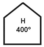
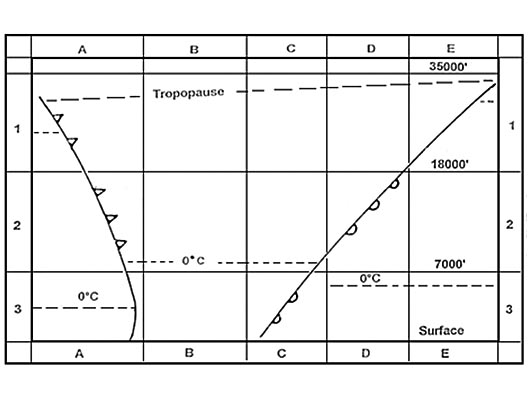
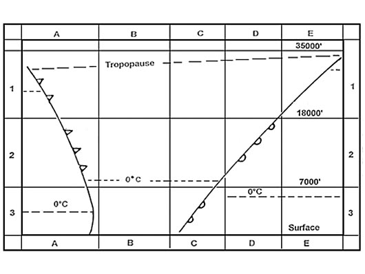
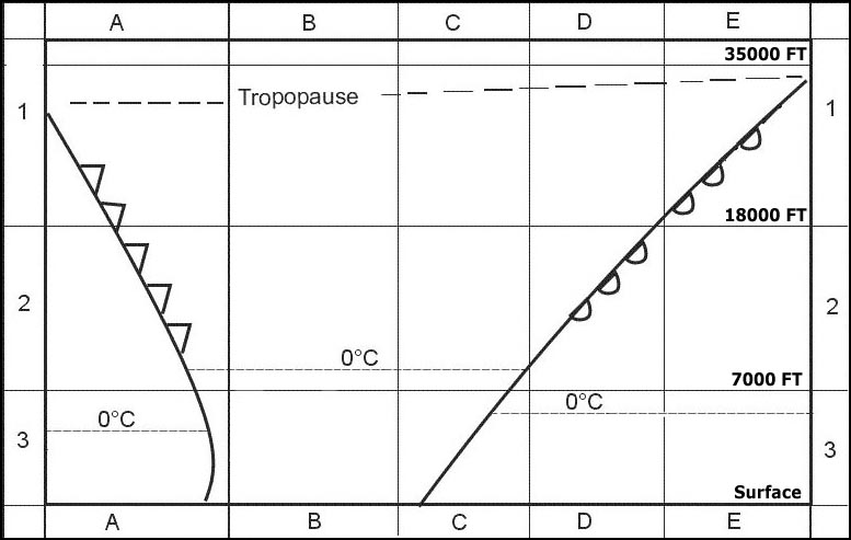
Question 120-24 : In the vicinity of paris 49°n 003°e the tropopause is at about err a 033 352 ?
Fl380.
200 km west of paris we have a box showing 400 this is the tropopause height north of paris near amsterdam tropause height is 350let's have a look to a jet stream cross section com encom033 352jpgbefore approaching the jet tropopause subsidesfl380 is the correct answer at the examFl340. fl350. fl400.
Question 120-25 : Given distance from departure to destination 1860 nm gs out 360 ktgs home 400 ktwhat is the time of the pet from the departure point ?
163 min.
132 min 147 min 22 min
Question 120-26 : Given distance from departure to destination 3000 nm safe endurance 8 h tas 520 kt ground speed out 600 kt ground speed home 440 kt what is the time of the psr from the departure point ?
203 min.
173 min 277 min 117 min
Question 120-27 : At reference or see flight planning manual mrjt 1 figure 431cfor a flight of 2800 ground nautical miles the following apply tail wind component 45 kttemperature isa 10°ccruise altitude 29000ftlanding mass 55000kgthe a trip fuel b trip time respectively are err a 033 371 ?
A 17100kg b 6h 07 min.
com encom033 371jpg613 h = 6h 08 minutes close to the answer (a) 16000kg (b) 6h 25 min (a) 18000kg (b) 5h 50 min (a) 20000kg (b) 6h 40 min
Question 120-28 : Given distance from departure to destination 150 nmsafe endurance 24 htrue track 250°wv 28015tas 120 ktwhat is the distance of the psr from the departure point ?
142 nm.
Start by searching outbound ground speed on nav computer set 120 kt under center dot true track 250° to true index put wind direction 280° under the red compass rose under 15 kt you read a groudspeed of 107 ktrepeat the opeartion to find homeward ground speedoutbound gs 107 kthomeward gs 134 ktpoint of safe return psr = endurance x homeward gs outbound gs + homeward gs point of safe return psr = 24 x 134 107 + 134 point of safe return psr = 3216 241point of safe return psr = 133 h033 x 60 = 20 minutes20 + 60 minutes = 80 mindistance of the psr from the departure point at a speed of 107 kt 80 min x 10760 = 1426 nm83 nm. 71 nm. 98 nm.
Question 120-29 : At reference or see flight planning manual mrjt 1 figure 431cfor a flight of 2400 ground nautical miles the following apply tail wind component 25 kttemperature isa 10°ccruise altitude 31000 ftlanding mass 52000 kgthe a trip fuel and b trip time respectively are err a 033 380 ?
A 14200 kg b 5 h 30 min.
com encom033 380gif(a) 16200 kg (b) 5 h 45 min. (a) 13600 kg (b) 6 h 30 min. (a) 12000 kg (b) 5 h 15 min.
Question 120-30 : Which best describes the maximum intensity of cat if any forecast for fl330 over benghazi 32°n 020°e err a 033 382 ?
Nil.
com encom033 382jpgcat area n°1 extends fl350 to fl450 so no clear air turbulence at fl330Light. moderate. severe.
Question 120-31 : At reference or see flight planning manual mep 1 figure 32a flight is to be made in a multi engine piston aeroplane mep the cruising level will be 11000 ftthe outside air temperature at fl is 15°cthe usable fuel is 123 us gallonsthe power is set to economic cruisefind the range in nm with 45 min ?
752 nm.
com encom033 384jpgoutside air temperature is 15°c it is 8°c below isareserve fuel is based at 45% power but for the flight we plan to use economic power 65% 852 nm. 610 nm. 602 nm.
Question 120-32 : Given distance from departure to destination 180 nm safe endurance 28 h true track 065 wv 24525 tas 100 kt what is the distance of the psr from the departure point ?
131 nm.
68 nm 66 nm 49 nm
Question 120-33 : Given distance from departure to destination 500 nm gs out 95 ktgs home 125 kt what is the distance of the pet from the departure point ?
284 nm.
216 nm 250 nm 380 nm
Question 120-34 : Which best describes the weather if any at lyonst exupery at 1330 utc err a 033 391 ?
Light rain associated with thunderstorms.
com encom033 391jpgts = thunderstormra = rainindicator ' ' means light to indicate the intensity of certain phenomenaexample from annex 3 +shra = heavy shower of rain+tssngr = thunderstorm with heavy snow and hailFrequent rain showers. fog. nil.
Question 120-35 : Given distance x to y 2700 nm mach number 075temperature 45°cmean wind component 'on' 10 kt tailwind mean wind component 'back' 35 kt tailwind the distance from x to the point of equal time pet between x and y is ?
1386 nm.
Set corresponding mark m kt against outside temperature at flight altitude read in front of mach number on the outer scale the true air speedexample 45° and mach 075 => tas is 437 kt com encom033 48jpgground speed out gso = 437 + 10 kt = 447 ktground speed home gsh = 437 + 35 kt = 472 ktdistance to pet = distance x gsh gso + gsh distance to pet = 2700 x 472 447 + 472 distance to pet = 1274400 919 = 1386 nm1350 nm. 1313 nm. 1425 nm.
Question 120-36 : At reference or see flight planning manual mep1 figure 36a flight is to be made to an airport pressure altitude 3000 ft in a multi engine piston aireroplane mep1 the forecast oat for the airport is 1° c the cruising level will be fl 110 where oat is 10° c calculate the still air descent distance ?
20 nm.
com encom033 398jpgdistance to descend = 29 8 = 21 nm close to the answer 29 nm. 36 nm. 25 nm.
Question 120-37 : Given distance from departure to destination 2800 nm true track 140 wv 140100 tas 500 kt what is the distance and time of the pet from the departure point ?
Distance 1680 nm time 252 min.
We start on a true track of 140° we have a 100 kt headwind thus ground speed out = 500 kt 100 kt = 400 ktground speed home = 500 kt + 100 kt = 600 ktpet = distance x gsh gso+ gsh pet = 2800 x 600 400 + 600 pet = 1680000 1000 = 1680 nmtime of the pet from the departure point 1680 400 = 42 h42 x 60 = 252 minutesDistance: 1120 nm time: 112 min distance: 1400 nm time: 168 min distance: 1120 nm time: 134 min
Question 120-38 : Route manual chart napthe initial magnetic course from c 62°n020°w to b 58°n004°e is err a 033 410 ?
116°.
com encom033 410jpgtrue course is 098° + 18°w magnetic variation = 116°080°. 098°. 113°.
Question 120-39 : Find the time to the point of safe return psr given maximum useable fuel 15000 kgminimum reserve fuel 3500 kgtas out 425 kthead wind component out 30 kttas return 430 kttailwind component return 20 ktaverage fuel flow 2150 kgh ?
2 h 51 min.
Point of safe return psr = endurance x homeward gs outbound gs + homeward gs outbound gs = 425 30 = 395 kthomeward gs = 430 + 20 = 450 ktendurance = 15000 3500 2150 = 534 hpoint of safe return psr = 534 x 450 395 + 450 point of safe return psr = 534 x 450 845 point of safe return psr = 284 h284 h = 2 h 51 minwe are talking about a point of safe return a decision in case of our destination is finally unreachable weather issue for example and legally we need to return to our departure airport with our minimum reserve fuel3 h 43 min 2 h 59 min 2 h 43 min
Question 120-40 : At reference or see flight planning manual mrjt 1 figure 41 find the optimum altitude for the twin jet aeroplanegiven cruise mass=54000 kglong range cruise or 74 mach err a 033 416 ?
34500 ft.
Img com encom033 416jpg33800 ft 35300 ft maximum operating altitude
~
Exclusive rights reserved. Reproduction prohibited under penalty of prosecution.