A free Premium account on the FCL.055 website! Read here
Sign up to unlock all our services and 15164 corrected and explained questions.
Question 151-1 : You intend to overfly a mountain range the recommended minimum flight altitude is according to the aviation chart 15000 ftamsl the air mass that you will fly through is on average 15°c warmer than the standard atmosphere the altimeter is set to qnh 1023 hpa at what altimeter reading will you ? [ Learning aircraft ]
14100 ft
Question 151-2 : You are flying at fl 130 and your true altitude is 12000 ft what is the temperature deviation from that of the standard atmosphere at fl 130 qnh 10132 hpa ?
Isa 20°c.
To determine the true altitudeheight the following rule of thumb called the 4% rule shall be used the altitudeheight changes by 4% for each 10°c temperature deviation from isa4 x 13 x temperature deviation = 1000 fttemperature deviation = 1000 ft 4 x 13 = 192°ctrue altitude is lower than pressure altitude so this is minus 20°cIsa +/-0°c. isa +20°c. isa +12°c.
Question 151-3 : Which one of the following statements applies to the tropopause ?
It separates the troposphere from the stratosphere.
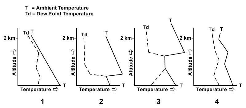
The tropopause is a boundary with no finite thickness the tropopause is the region of the atmosphere where the environmental lapse rate changes from positive as it behaves in the troposphere to the stratospheric negative one following is the exact definition used by the world meteorological organization the boundary between the troposphere and the stratosphere where an abrupt change in lapse rate usually occurs it is defined as the lowest level at which the lapse rate decreases to 2 °ckm or less provided that the average lapse rate between this level and all higher levels within 2 km does not exceed 2 °ckm It is, by definition, an isothermal layer it indicates a strong temperature lapse rate it is, by definition, a temperature inversion
Question 151-4 : The 0° isotherm is forecast to be at fl 50 at what fl would you expect a temperature of 6°c ?
Fl 80.
The temperature lapse rates of the troposphere is mean value 065°c100 m or 2°c1000 ft6° 2° per 1000 ft = 3000 ftfl50 + 3000 ft = fl80Fl 20. fl 100. fl 110.
Question 151-5 : A vertical spacing of 1000 ft is the standard required separation between two fl under conditions of cold air advection isa 15°c what would the true vertical separation be ?
Less than 1000 ft.
515in flight level aircraft are using the same subscale reference 101325 hpatheoretical separation is 1000 ft actual separation is less when air mass is colder than standardIt remains 1000 ft. more than 1000 ft. without qnh information, it can not be determined.
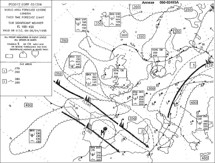
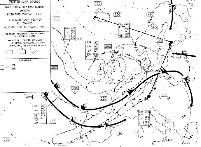
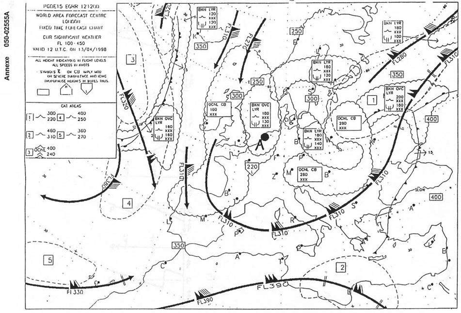
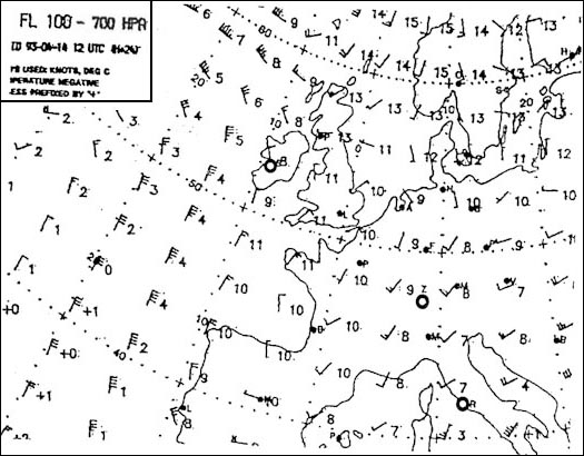
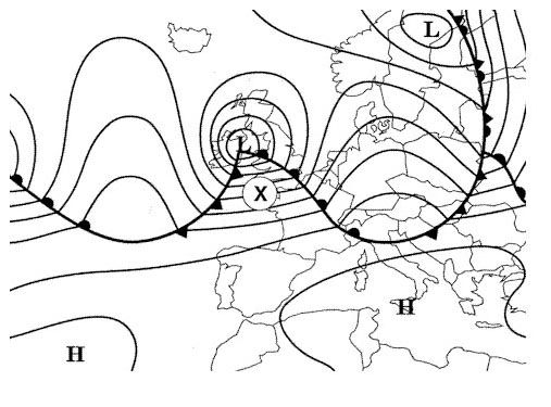
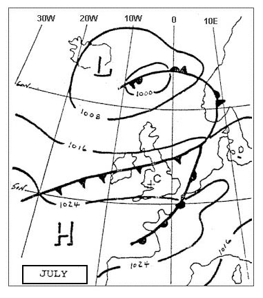
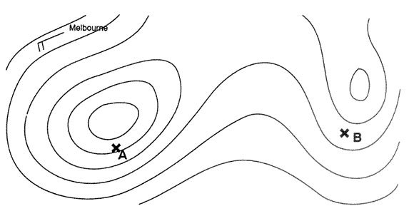
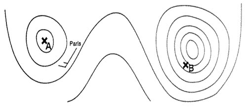
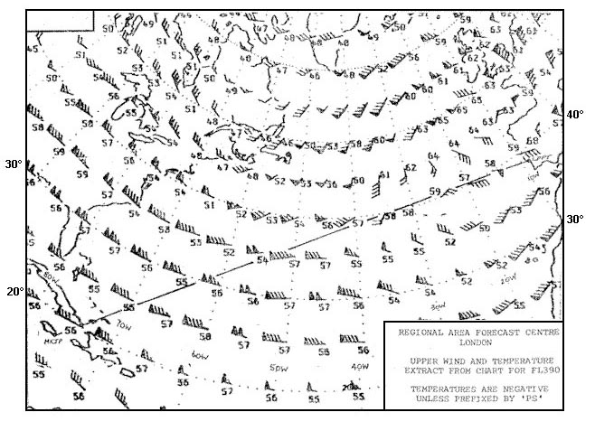
Question 151-6 : Over paris at what flight level would you expect to find the tropopause according to the map 269 ?
Fl 300.
Tropopause is at fl290 north est and at fl340 south west of pariswe would expect to find the tropopause at fl300 over parisFl 330. fl 150. fl 280.
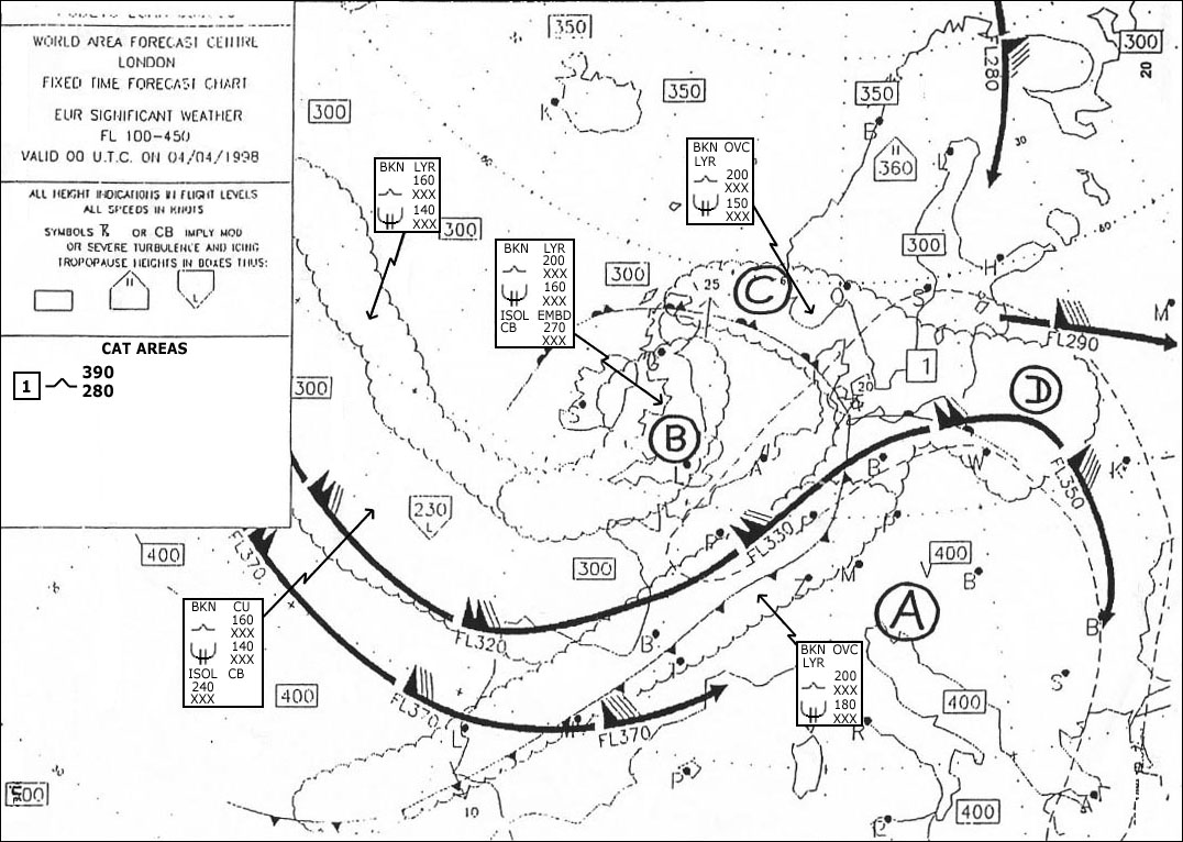
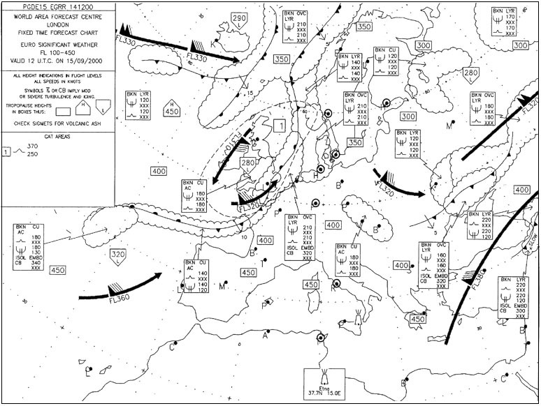
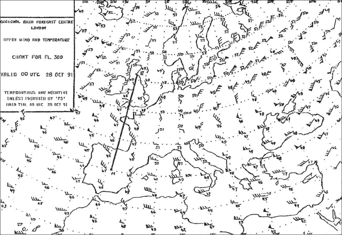
Question 151-7 : What is the approximate height of the tropopause between munich and helsinki 271 ?
Fl 340.
523the approximate height of the tropopause between munich and helsinki is fl340400 on the one hand 300 on the other hand even if the height change is not uniform fl340 remains the only valid answerFl 280. fl 300. fl 390.
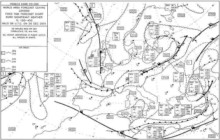
Question 151-8 : At what approximate flight level is the tropopause over frankfurt 276 ?
Fl 330.
526you have to interpolate between different heights placing the tropopause at approximately fl 330 over frankfurtFl 300. fl 350. fl 240.
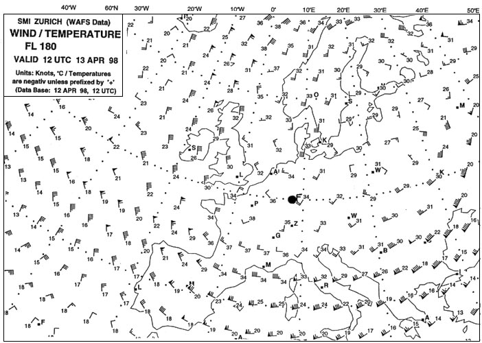
Question 151-9 : The temperature at fl 330 overhead london will be 278 ?
45°c.
The height of the tropopause over london is fl290 above the tropopause the temperature stays constant close to london t° is around 45°c at fl390 so between fl290 and fl390 no change-39°c. -33°c. -57°c.
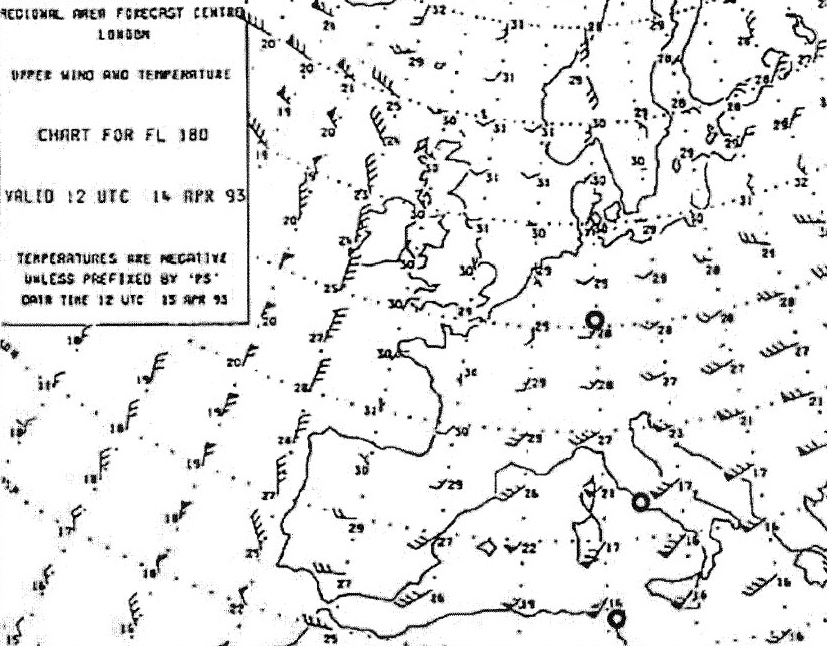
Question 151-10 : What is the average temperature at fl 160 between oslo and paris 282 ?
19°c.
This chart is given for fl180at fl180 between oslo and paris average temperature is 25 + 24 + 23 + 21 + 21 5 = 114 5 = around 23°caverage temperature at fl160 is 4° warmer 2° per 1000ft = 19°c-23°c. -15°c. -25°c.
Question 151-11 : What is the temperature deviation in degrees celsius from the icao standard atmosphere overhead frankfurt 283 ?
Isa 13°c.
At fl180 in a standard atmosphere temperature is 15° 2° x 18 = 21ºcon the chart overhead frankfurt temperature at fl180 is 34°ctemperature deviation is 34° + 21° = 13°cwe can say that temperature overhead frankfurt at fl180 is colder than icao standard atmosphereIsa -2°c isa +13°c isa +2°c
Question 151-12 : What oat would you expect at fl 200 over geneva 289 ?
24°c.
This chart is given for fl180at fl180 average temperature is 20 + 21 + 19 + 21 4 = 81 4 = around 20°caverage temperature at fl200 is 4° colder 2° per 1000ft = 24°c-20°c. -16°c. -28°c.
Question 151-13 : An altimeter adjusted to 1013 hpa indicates an altitude of 3600 ft should this altimeter be adjusted to the local qnh value of 991 hpa the altitude indicated would be ?
3006 ft.
Your altimeter adjusted to 1013 hpa indicates an altitude of 3600 ftyou have to turn altimeter setting adjustement knob in a counter clockwise direction to set 991 hpa in the subscale window the altimeter needle will turn in the same direction counter clockwise 541decreasing altimeter setting by 22 hpa 1013 991 22 hpa x 27 fthpa = 594 ftindicated altitude decreases by 594 ft 3600 594 = 3006 ft2922 ft. 4278 ft. 4194 ft.
Question 151-14 : In geneva the local qnh is 994 hpa the elevation of geneva is 1411 ft the qfe adjustment in geneva is ?
942 hpa.
The qfe indicates in standard atmosphere the height of the aircraft above the official airport elevation an altimeter set to qfe will therefore read zero when on the ground qnh is the setting which will give airfield elevation when parked on the airfieldwith a subscale setting of 994 hpa on the ground at geneva your altimeter reads 1411 ftyou want to read 0 ftyou must turn anti clockwise the adjustment knob 1 hpa = 27 ft1411 27 = 50 hpa994 52 = 942 hpa 531967 hpa. 961 hpa. 952 hpa.
Question 151-15 : An aircraft is flying at fl 80 the local qnh is 1000 hpa after the second altimeter has been adjusted to the local qnh the reading will be approximately ?
7650 ft.
Your main altimeter remains at 1013 hpa with a reading of 8000 ft the second is set at 1000 hpa you have to turn altimeter setting adjustement knob in a counter clockwise direction the altimeter needle will turn also counter clockwise 541decreasing altimeter setting by 13 hpa 13 hpa x 27 fthpa = 351 ftindicated altitude decreases by 351 ft 8000 351 = 7649 ft8600 ft. 8350 ft. 8000 ft.
Question 151-16 : The barometric compensator of an altimeter is locked on reference 10132 hpa the aircraft has to land on a point with an elevation of 290 feet where the qnh is 1023 hpa the reading on the altimeter on the ground will be ?
20 ft.
1023 1013 = 10 hpa10 hpa x 27 fthpa = 270 ft290 ft 270 ft = 20 ftimagine if you landed on this airfield with the correct subscale setting 1023 hpa the reading on the altimeter on the ground will be 290 ft now if you set 1013 hpa in the subscale the needles will turn couter clockwise and the altimeter will read 20 ft11 ft. -10 ft. 560 ft.
Question 151-17 : The upper wind and temperature chart of 250 hpa corresponds in a standard atmosphere to about ?
34 000 ft.
There is a few questions in the exam that take information directly from that table below write these down on a sticky and have them on the wall beside you 1013 hpa = msl850 hpa = fl50700 hpa = fl100500 hpa = fl180300 hpa = fl300200 hpa = fl390any others you can interpolate between these and figure it outthe decrease of 1hpa27 ft is only applicable at the lower levels of the troposphere as you go up and air pressure decreases the change of height per 1 hpa increases at msl 1hpa27ft at fl180 it's 50fthpa and at fl390 it's 105fthpa 39 000 ft. 30 000 ft. 32 000 ft.
Question 151-18 : Going from the equator to the north pole the altitude of the tropopause ?
Decreases and its temperature increases.
491height of the tropopausepolar tropopause 8 km 45°ctropicale tropopause 15 km 75°cequatorial tropopause 16 km 80°cIncreases and its temperature increases. increases and its temperature decreases. decreases and its temperature decreases.
Question 151-19 : Atmospheric soundings give the following temperature profile 3000 ft +15°c6000 ft +8°c10000 ft +1°c14000 ft 6°c18000 ft 14°c24000 ft 26°cat which of the following flight levels is the risk for aircraft icing in cloud greatest ?
Fl 150.
Greatest icing occurs at temperature between 0°c and 10°ctemperature at fl80 is largely positive at around +4°c there will be no risk of icingat fl150 temperature is around 8°c severe icing has greatest possibility to occurtemperature above fl160 will be lower than 10°c risk for aircraft icing is possible but with a less intensity than temperature between 0°c and 10°cFl 220. fl 80. fl 180.
Question 151-20 : Half the mass of the atmosphere is found in the first ?
5 km.
11 km. 3 km. 8 km.
Question 151-21 : The thickness of the troposphere varies with ?
Latitude.
Tropopause is the boundary layer between troposphere and stratosphere 49116 km is approximately the average thickness of the troposphere over the equator 0° ns of latitude at 45° of latitude the thickness is around 12 kmat poles 90° ns of latitude the thickness is around 8 kmthe thickness of the troposphere varies with latitudeLongitude. rotation of the earth. the wind.
Question 151-22 : In the lower part of the stratosphere the temperature ?
Is almost constant.
633 in the real world in the lower part of the stratosphere the temperature is rising a little with altitude but in isa noDecreases with altitude. increases with altitude. increases at first and decreases afterward.
Question 151-23 : Which of the following conditions would cause the altimeter to indicate a lower altitude than that actually flown ?
Air temperature higher than standard.
If the temperature or pressure is higher than isa your true altitude will be higher than indicated you are safe if the temperature or pressure is lower than isa your true altitude will be lower than indicated or closer to the ground which is dangerousif it is cold imagine the air 'shrinking' down so the pressure level will be closer to the ground while if it is hot the air will 'expand' so the pressure level will be higher above the groundremember the altimeter is reading a pressure level but it does not know how high the pressure level is above the ground if you are flying at 10000 ft indicated you are following the 700 hpa line and although you are keeping the altimeter at 10000 ft you will not always be at 10000 ft above the groundAtmospheric pressure lower than standard. pressure altitude the same as indicated altitude. air temperature lower than standard.
Question 151-24 : The qff at an airfield located 400 metres above sea level is 1016 hpa the air temperature is 10°c lower than a standard atmosphere what is the qnh ?
Less than 1016 hpa.
Qff is atmospheric pressure at sea levelqnh is the setting which will give airfield elevation when parked on the airfieldin cold conditions a column of air will shrink so the 'cold' qnh will be less than qff and the 'warm' qnh will be more than qffthis table will help for the exam 5391016 hpa. more than 1016 hpa. it is not possible to give a definitive answer.
Question 151-25 : The qnh at an airfield located 200 metres above sea level is 1009 hpa the air temperature is 10°c lower than a standard atmosphere what is the qff ?
More than 1009 hpa.
Qff is atmospheric pressure at sea levelqnh is the setting which will give airfield elevation when parked on the airfieldin cold conditions a column of air will shrink so the cold qnh will be less than qff and the warm qnh will be more than qffthis table will help for the exam 5391009 hpa. less than 1009 hpa. it is not possible to give a definitive answer.
Question 151-26 : The qnh at an airfield located 200 metres above sea level is 1022 hpa the air temperature is not available what is the qff ?
It is not possible to give a definitive answer.
Qff is atmospheric pressure at sea levelqnh is the setting which will give airfield elevation when parked on the airfieldin cold conditions a column of air will shrink so the 'cold' qnh will be less than qff and the 'warm' qnh will be more than qffthis table will help for the exam 539we need to know the temperatureMore than 1022 hpa. 1022 hpa. less than 1022 hpa.
Question 151-27 : The qnh at an airfield located 0 metres above sea level is 1022 hpa the air temperature is not available what is the qff ?
1022 hpa.
Qff is atmospheric pressure at sea levelqnh is the setting which will give airfield elevation when parked on the airfieldin cold conditions a column of air will shrink so the 'cold' qnh will be less than qff and the 'warm' qnh will be more than qffthis table will help for the exam 539when temperature is unknown you are unable to calculate qff expect at mean sea levelat sea level qfe = qnh = qff regardless of temperature because you are not correcting up or down to find msl pantalejandro fast and furious analogy qff = fast furiousfrom the starting point all 3 race cars 'qfe qnh and qff' are at same position msl same pressure value as the race goes on qff =>fast furious' will lead if it is cold colder than isa= more thrust => 'qnh is less' or will lag behind if it is warm warmer than isa = less thrust => 'qnh is more' while the other two cars will go hand by handnote below msl the story is reverted > qff less if colderi made this out hope it works for you guysLess than 1022 hpa. more than 1022 hpa. it is not possible to give a definitive answer.
Question 151-28 : The qnh at an airfield in california located 69 metres below sea level is 1018 hpa the air temperature is 10°c higher than a standard atmosphere what is the qff ?
More than 1018 hpa.
Qff is atmospheric pressure at sea levelqnh is the setting which will give airfield elevation when parked on the airfieldin cold conditions a column of air will shrink so the 'cold' qnh will be less than qff and the 'warm' qnh will be more than qffthis table will help for the exam 5391018 hpa. it is not possible to give a definitive answer. less than 1018 hpa.
Question 151-29 : The qff at an airfield in california located 69 metres below sea level is 1030 hpa the air temperature is 10°c lower than a standard atmosphere what is the qnh ?
More than 1030 hpa.
Qff is atmospheric pressure at sea levelqnh is the setting which will give airfield elevation when parked on the airfieldin cold conditions a column of air will shrink so the 'cold' qnh will be less than qff and the 'warm' qnh will be more than qffthis table will help for the exam 539Less than 1030 hpa 1030 hpa it is not possible to give a definitive answer
Question 151-30 : If the qfe at locarno 200 metres above sea level is 980 hpa what is the approximate qnh ?
1005 hpa.
The qfe indicates in standard atmosphere the height of the aircraft above the official airport elevation an altimeter set to qfe will therefore read zero when on the ground and you want the qnh to read an altitude qfe 980 hpa|| 200m 8m per hpa = 25 hpa|| qnh 1005 hpa1000 hpa. 1015 hpa. 1010 hpa.
Question 151-31 : If the qfe at locarno 200 metres above sea level is 1000 hpa what is the approximate qnh ?
1025 hpa.
The qfe indicates in standard atmosphere the height of the aircraft above the official airport elevation an altimeter set to qfe will therefore read zero when on the ground and you want the qnh to read an altitude qfe 1000 hpa|| 200m 8m per hpa = 25 hpa|| qnh 1025 hpa985 hpa. 990 hpa. 1035 hpa.
Question 151-32 : If the qnh at locarno 200 metres above sea level is 1015 hpa what is the approximate qfe ?
990 hpa.
The qfe indicates in standard atmosphere the height of the aircraft above the official airport elevation an altimeter set to qfe will therefore read zero when on the ground qnh is the setting which will give airfield elevation when parked on the airfield qfe 990hpa|| 200m 8m per hpa = 25hpa|| qnh 1015hpause this craftiness your altimeter is reading 675 ft 200 m when parked on the airfield with a subscale setting of 1015 hpa you want to read 0 ft the qfe you must decrease the subscale setting until the needle shows 0 ft the adjustment knob turns counter clockwise as the needle 541995 hpa. 1000 hpa. 1005 hpa.
Question 151-33 : If the qnh at locarno 200 metres above sea level is 1025 hpa what is the approximate qfe ?
1000 hpa.
The qfe indicates in standard atmosphere the height of the aircraft above the official airport elevation an altimeter set to qfe will therefore read zero when on the ground qnh is the setting which will give airfield elevation when parked on the airfield qfe 1000hpa|| 200m 8m per hpa = 25hpa|| qnh 1025hpause this craftiness your altimeter is reading 675 ft 200 m when parked on the airfield with a subscale setting of 1025 hpa you want to read 0 ft the qfe you must decrease the subscale setting until the needle shows 0 ft the adjustment knob turns counter clockwise as the needle 541995 hpa. 1005 hpa. 1025 hpa.
Question 151-34 : If you are flying at fl 300 in an air mass that is 15°c warmer than a standard atmosphere what is the outside temperature likely to be ?
30°c.
In standard atmosphere the decrease in temperature per 1000 feet is 2°cin standard atmosphere temperature is 15°c at 0 ftat fl300 temperature is 15°c 30 x 2°c = 45°cair mass is 15°c warmer than standard 45°c + 15°c = 30°c-45°c. -60°c. -15°c.
Question 151-35 : If you are flying at fl 100 in an air mass that is 10°c warmer than a standard atmosphere what is the outside temperature likely to be ?
+5°c.
In standard atmosphere the decrease in temperature per 1000 feet is 2°cin standard atmosphere temperature is 15°c at 0 ftat fl100 temperature is 15°c 10 x 2°c = 5°cair mass is 10°c warmer than standard 5°c + 10°c = +5°c+15°c. -10°c. -15°c.
Question 151-36 : If you are flying at fl 120 and the outside temperature is 2°c at what altitude will the 'freezing level' be ?
Fl 110.
In standard atmosphere the decrease in temperature per 1000 feet is 2°cat fl120 temperature is 2°c1000 ft below temperature will be 2° warmer1000 ft above temperature will be 2° colderthe 'freezing level' 0°c will be at fl 110Fl 130. fl 150. fl 90.
Question 151-37 : An aircraft flying at fl 100 from marseille qnh 1012 hpa to palma de mallorca qnh 1006 hpa experiences no change to true altitude the reason for this is that ?
The air at palma de mallorca is warmer than that at marseille.
Case n°1 540if temperature is the same between both locations the true altitude will be reduced over palma by 6 hpa around 162 ft case n°2The air at palma de mallorca is colder than that at marseille. the altimeters are erroneous, and need to be tested. one of the two qnh values may be incorrect.
Question 151-38 : During a flight over the sea at fl 100 from marseille qnh 1012 hpa to palma de mallorca qnh 1012 hpa the true altitude is constantly increasing what action if any should be taken ?
None the reason for the change is that the air around palma is warmer than the air around marseille.
Have your altimeter checked, because its readings are obviously wrong recheck the qnh because one of the qnh values must be wrong compensate by heading further to the left
Question 151-39 : During a flight over the sea at fl 100 from marseille qnh 1016 hpa to palma de mallorca qnh 1016 hpa the true altitude is constantly decreasing what is the probable reason for this ?
The air at marseille is warmer than that at palma de mallorca.
If the qnh remains unchanged and the true altitude is constantly decreasing the only reason is a reduction of the volume of the 'air mass' how an 'air mass' can contract the temperature is decreasing and thus the density is increasing the air at palma de mallorca is colder than that at marseille in other words air at marseille is warmer than that at palma de mallorca One of the qnh values must be wrong. the altimeter is faulty. the air at palma de mallorca is warmer than that at marseille.
Question 151-40 : During a flight over the sea at fl 135 the true altitude is 13500 feet local qnh is 1019 hpa what information if any can be gained about the air mass in which the aircraft is flying ?
It is colder than isa.
If you are flying at fl135 your subscale altimeter setting is 1013 hpaif the local qnh is 1019 hpa and if you set your second altimeter with this value you will normally read more than 13500 ftbut you read today 13500 ft this is your true altitude it means that the air mass is colder than isa air mass is contracted Its average temperature is the same as isa. it is warmer than isa. there is insufficient information to make any assumption.
~
Exclusive rights reserved. Reproduction prohibited under penalty of prosecution.