A free Premium account on the FCL.055 website! Read here
Sign up to unlock all our services and 15164 corrected and explained questions.
Question 154-1 : What is approximately the temperature at 20000 ft in the icao standard atmosphere ? [ Learning aircraft ]
25°c
Question 154-2 : What is the most probable temperature at the tropical tropopause ?
75°c.
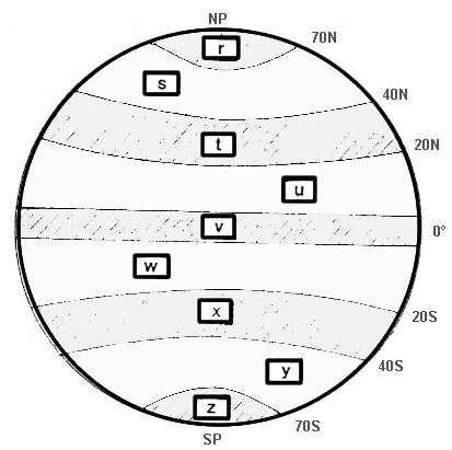
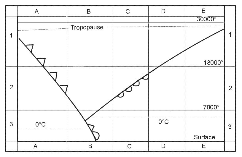
The tropopause is at the top of the troposphere it marks the boundary between the troposphere and the next atmospheric layer the stratosphere the tropopause is defined as being that part of the atmosphere where temperature no longer decreases with heightthe temperature at the tropopause can be as high as 40°c over the poles and as low as 80°c over the equator the average height of the tropopause is at about 11 km where its temperature is 565°cabove tropical regions 15° 30° n and s the most probable temperature is 75°c-55°c. -35°c. -25°c.
Question 154-3 : What is the average temperature difference from isa at fl 300 between edinburgh and madrid 339 ?
2°c.
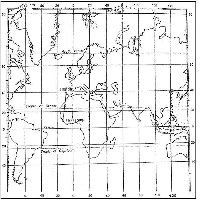
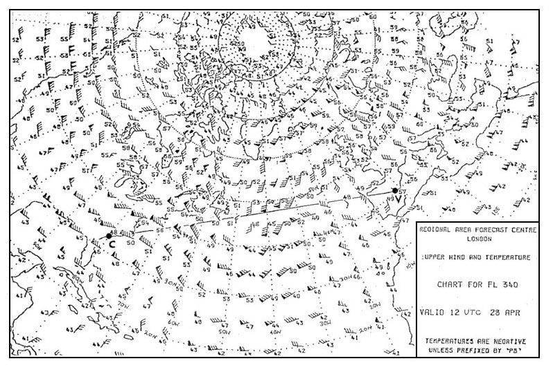
From edinburg to madrid at fl300 temperatures are 49 + 48 + 47 + 47 + 46 + 46 + 47 7 = 47°cisa temperature at fl300 is 15º 2º x 30 = 45ºcaverage oat outside air temperature is 2°c colder than isa+12°c. +2°c. -12°c.
Question 154-4 : Considering the route between valencia and charleston at fl 340 the forecast mean temperature is 342 ?
50°c.
At fl340 between valencia and charleston average temperature is around 50°cpick up some temperatures close to the track 616 48+56+50+50+45+50+46+48+57 9 = 50°c minus 50°c -45°c -55°c -40°c
Question 154-5 : The temperature lapse rate of the standard atmosphere in the troposphere is ?
2°c1000 ft.
3°c/1000 ft. 6,5°c/1000 ft. 2,5°c/1000 ft.
Question 154-6 : The radiosonde can directly measure ?
Atmospheric pressure air temperature humidity.
Pressure temperature and humidity are measured using three capacitative sensors a radiosonde 'sonde' is french for probe is a unit for use in weather balloons that measures various atmospheric parameters and transmits them to a fixed receiverwind speed and direction are not directly measured by the radiosonde wind speed and direction can be determined from additional windfinding equipment these parameters are calculated from the position of the sonde at successive time intervalsAir temperature, humidity, wind. humidity, wind, atmospheric pressure. wind, atmospheric pressure, air temperature.
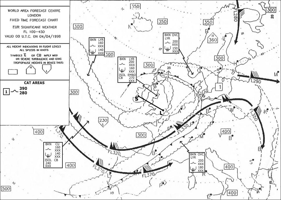
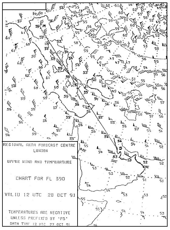
Question 154-7 : Flight from lisbon lppt to kingston mkjp at 40°n 20°w the temperature deviation from isa at fl 390 is 2534 ?
0°c.
624 567 is considered to be the lowest isa temperature so temperature deviation from isa at fl 390 is 0°+6°c. +2°c. -2°c.
Question 154-8 : At which pressure and temperature conditions may you safely assume that the minimum usable flight level at least lies at the same height as the minimum safe altitude ?
At a temperature greater than or equal to that of the isa and where the qnh is greater than or equal to 101325 hpa.
If the qnh is more than 101325 hpa our true altitude will be more than our pressure altitude flight level example qnh 1023 fl 100 pressure altitude 10000 ft our true altitude will be approximately 10300 ftalso if it is warmer than isa our true altitude will be higher than our indicated altitudeIn a cold low pressure region. at a temperature less than or equal to that of the isa and where the qnh is less than 1013.25 hpa. in a very cold area with a qnh of 1015 hpa.
Question 154-9 : Given altimeter setting 10132 hpaaltimeter reading 5000 ftoutside air temperature at 5000 ft +5°cqfe 958 hpaqnh 983 hpawhat is the true height of the aeroplane above the aerodrome ?
3515 ft.
1013 958 = 55 hpa55 hpa x 27 = 1485 ftisa temperature at 5000 ft 15°c 2°c x 5 = +5°c oat = isa so we are in isa conditions 5000 1485 = 3515 ftyou are flying at fl50 subscale setting 101315 hpa you turn counterclockwise your subscale setting knob until the scale reads 958 hpa indicated altitude will decrease by 55 ft x 27 ft = 1485 ft and becomes a true height since the subscale scale is qfe qfe indicates the height of the aircraft above the aerodrome in standard atmosphere to find the answer you must do 5000 675 810 = 3515675 is difference between the ground and msl qnh 810 is difference between the msl and fl4190 ft. 4325 ft. 4865 ft.
Question 154-10 : At fl 180 the air temperature is 35°c the air density at this level is ?
Greater than the density of the isa at fl 180.
At fl180 the isa deviation is 14ºc which is obviously colder heating reduces density volume is greater a parcel of the air expands cooling increases density volume is lower a parcel of the air shrinks final statement density is inversely proportional to temperature so if it's colder density is higher if it's hotter density is lower Less than the density of the isa at fl 180. equal to the density of the isa at fl 180. unable to be determined without knowing the qnh.
Question 154-11 : An aircraft flies at flight level 40 elevation of the aerodrome 990 ft and qnh 976 hpa the tower clears the pilot to fly at 3000 ft qnhwhich of the following statements is correct ?
Only a small change of altitude is necessary.
You are flying at fl 40 with a subscale of 1013 hpaat 990 ft qnh is 976 hpadifference between 1013 and 976 is 37 hpa37 hpa x 27 ft = 999 ftwhile flying at fl40 at 1013hpa setting you are in reality at 4000 999 = 3001 ft for a 976 hpa subscale settingthe tower clears the pilot to fly at 3000 ft qnh he has to descend 1 ft to reach 3000 ft at 976 hpa The aircraft has to climb about 1000 ft. the aircraft has to descend about 1000 ft. the aircraft has to descend about 2000 ft.
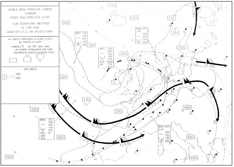
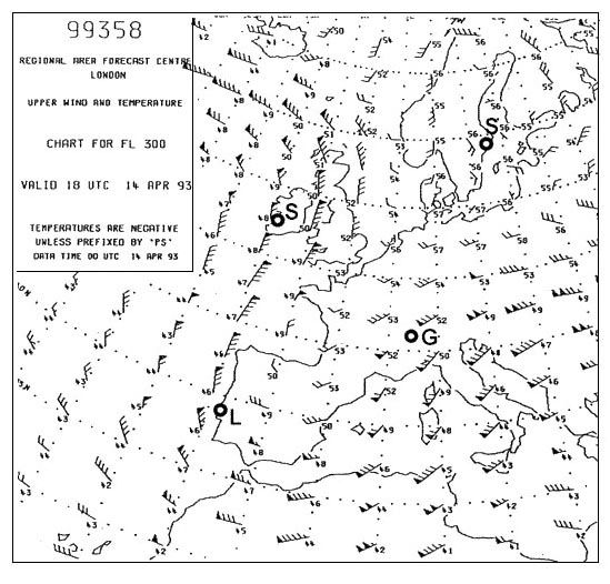
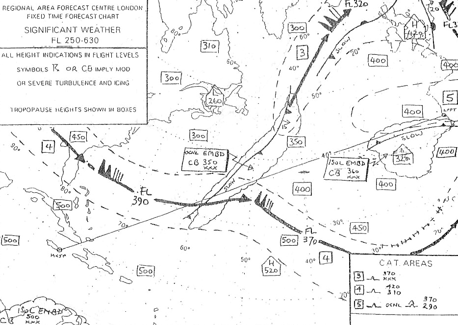
Question 154-12 : The mean temperature that may be expected to affect that segment of the route from the coast of se england to geneva at fl 270 is ?
38°c.
Be careful we are looking at the temperature only for the part from the coast of se england to geneva not from dublin to tunisover manche at fl240 temperature is 35°before geneva at fl240 temperature is 30°over manche at fl300 temperature is 48°before geneva at fl300 temperature is 44°average temperature at fl240 = 35° + 30° 2 = 325°caverage temperature at fl300 = 48° + 44° 2 = 46°caverage temperature at fl270 = 325° + 46° 2 = 39°c-34°c. -30°c. -42°c.
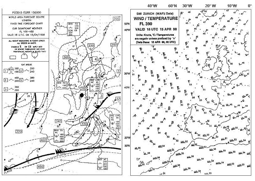
Question 154-13 : Flight from lisbon lppt to kingston mkjp considering the route segment between 60°w and 70°w at fl 390 the forecast mean temperature is 368 ?
55°c.
631we are only looking for the mean temperature forecast between 60°w and 70°w -52°c. -58°c. -61°c.
Question 154-14 : What is the average temperature difference from isa at fl 390 between madrid and dhahran 370 ?
1°c.
The lowest temperature in the icao standard atmosphere isa is 565°caverage temperature between madrid and dhahran is around 57°c this is about 1°c colder+5°c -5°c +2°c
Question 154-15 : The diurnal variation in temperature is largest when ?
The sky is clear and the wind is weak.
The sky is clear and the wind is strong the sky is overcast and the wind is weak the sky is overcast and the wind is strong
Question 154-16 : Which of the following statements concerning the tropopause is correct ?
The temperature lapse rate changes abruptly at the tropopause.
633at the tropopause the temperature remains constant until 25 km then it increasesthe lapse rate changes abruptly at the tropopauseThe temperature remains constant above and below the tropopause. the temperature of the tropopause at the equator is higher than at the poles. the temperature of the tropopause at the equator and at the poles is equal.
Question 154-17 : An aircraft is flying through the alps on a very cold winter's day the regional qnh is 1013 hpaduring the flight you circle around a mountain at an altitude of its summitwhat reading will the aneroid altimeter give compared to the elevation of the summit ?
A higher altitude than the elevation of the summit.
On a very cold winter's day means an outside temperature well below isa temperature if the summit is at 10000 ft you will normally read an altitude of 10000 ft in standard atmospheresince outside temperature is well below isa temperature the air mass is contracted your altimeter will read a higher altitude than the elevation of the summitA lower altitude than the elevation of the summit. the same altitude as the elevation of the summit. there is insufficient information to come to a conclusion.
Question 154-18 : An aircraft is flying through the alps on a warm summer's day the weather is fine and there is a high pressure system in the areaduring the flight a mountain is passed at an altitude of its summitwhat reading will the aneroid altimeter give compared to the summit's elevation ?
A lower altitude than the elevation of the summit.
If the summit's elevation is 10000 ft and the aircraft is at a real height of 10000 ft with high temperature the altimeter under read the aircraft's altitude and it reads a lower altitude than the elevation of the summitif now you fly at an indicated altitude of 10000 ft you will pass largely over the summit's elevationif you fly imc and having to pass over this summit with a 1000 ft margin in cold days you must be at a higher indicated altitude than 11000 ft to be 'in reality' at or above 11000 ftA higher altitude than the elevation of the summit. the same altitude as the elevation of the summit. there is insufficient information to come to a conclusion.
Question 154-19 : What is the approximate vertical interval which is equal to a pressure change of 1 hpa at sea level ?
8 m 27 ft .
Cqb15 july 201115 m (50 ft). 32 m (105 ft). 64 m (210 ft).
Question 154-20 : On a route segment from a to b the highest terrain elevation is approximately 200 feet for an instrument flight the minimum obstacle clearance is 1000 feet the subscale of the altimeter is set to the local qnh of 1013 hpa and the temperature on the ground is 5°c assume a standard temperature lapse ?
1300 feet.
We actually need to fly at 1000 + 200 = 1200 fttemperature at 200 ft or 0 ft it's not a big deal is 5°ctemperature is colder than isa our altimeter must read an altitude higher than 1200 ft to be sure not to be lower than 1200 ftisa temperature at 1000 ft is 13°c today it is 7°c we 'lose' 2° per 1000 ft difference between isa is 20°caltitudeheight changes by 4% for each 10°c temperature deviation from isatemperature correction = 4 x 12 x 20 temperature correction = 96 ftour altimeter must read at least 1296 ft and we will really fly over the mountain at 1200 ftanswer 1300 ft is our minimum acceptable altimeter indication1400 feet. 1100 feet. 1000 feet.
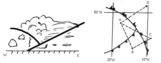
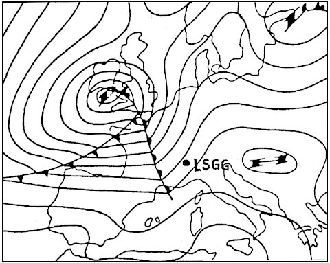
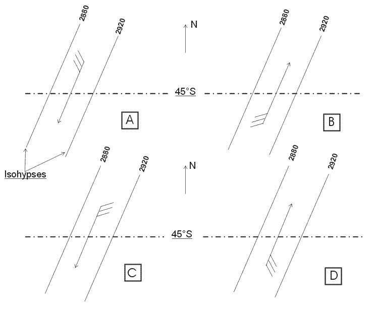
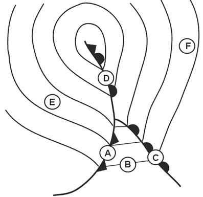
Question 154-21 : An aircraft is flying from point a to point b at the flight level corresponding to the pressure surface of the constant pressure chartwhich of the following statements is correct 376 ?
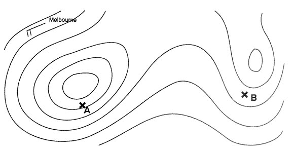
Wind speed over b is higher than over a.
If you stand with your back to the wind in the northern hemisphere low pressure is on your left buys ballot's law with a wind coming from the west direction and you stand with your back to it low pressure is on your left 542on the annex a is on a higher contour line than b true altitude will be higher at a and over london than at bisobars are tighter at b than a so wind speed over b is higher than over aThe true altitude will be higher over b than over a. wind speed over a is higher than over b. the true altitude will be higher over b than over london
Question 154-22 : Which of the following constant pressure charts would be most relevant for planning a flight at fl 430 ?
150 hpa.
There is a few questions in the exam that take information directly from that table below write these down on a sticky and have them on the wall beside you 1013 hpa = msl850 hpa = fl50700 hpa = fl100500 hpa = fl180300 hpa = fl300200 hpa = fl390any others you can interpolate between these and figure it outthe decrease of 1hpa27ft is only applicable at the lower levels of the troposphere as you go up and air pressure decreases the change of height per 1 hpa increases at msl 1hpa27ft at fl180 it's 50fthpa and at fl390 it's 105fthpa 200 hpa. 250 hpa. 300 hpa.
Question 154-23 : By volume which of the following elements makes up the largest part of the atmosphere ?
Nitro.
Hydrogen. oxygen. noble gases.
Question 154-24 : Which fl corresponds with the 400 hpa pressure level ?
Fl 240.
Fl 300. fl 340. fl 140.
Question 154-25 : By volume what percentage of the air in the lower troposphere consists of water vapour ?
0 5%.
Water vapour varies by volume in the lower troposphere from a trace to about 5% therefore on average only about 2 to 3% of the molecules in the air are water vapour molecules the amount of water vapour in the air is small in extremely arid areas and in location where the temperatures are very low ie polar regions very cold weather the volume of water vapour is about 5% in very warm and humid tropical air5-10%. 10-15%. 20-30%.
Question 154-26 : Consider a parcel of air being forced upwards in the atmosphere the lapse rate of the surrounding air is less than the saturated adiabatic lapse rate after the initial force is no longer effective the parcel of air ?
Will tend to descend to its original altitude.
This is clearly the description of stabilityif a parcel of air is forced to rise it will be colder than the air it is rising into so the moment the trigger stops lifting it it will sink back to the level it started from because it is more dense the layer is stableWill tend to ascend further. will tend to remain at the new altitude. will become conditionally unstable.
Question 154-27 : What kind of turbulence is dependent on the sun's radiation and therefore follows a pronounced diurnal pattern ?
Convective turbulence.
Mechanical turbulence. orographic turbulence. turbulence induced by wind speed.
Question 154-28 : What is meant by qfe ?
The atmospheric pressure at the official aerodrome elevation.
Qfe = q code used by pilots and atc that refers to atmospheric pressure and altimeter settings f field e elevation The atmospheric pressure at the official aerodrome elevation, reduced to mean sea level in standard atmospheric conditions. the pressure at msl in standard atmospheric conditions. the present atmospheric pressure at an aerodrome converted to mean sea level in accordance with the actual conditions.
Question 154-29 : When the subscale of a pressure altimeter is set to the qfe of the destination airfield it will indicate ?
Zero at landing roll out.
Airfield elevation at landing roll out. more than the airfield elevation. the aircraft's altitude above msl.
Question 154-30 : If the subscale of an altimeter is set to qnh what will it indicate after landing ?
Aerodrome elevation.
Less than aerodrome elevation when it is colder than standard, more than aerodrome elevation when it is warmer than standard. less than aerodrome elevation when pressure is lower than standard, more than aerodrome elevation when pressure is higher than standard. pressure altitude.
Question 154-31 : The mean height of the tropical tropopause is ?
44000 ft.
Ecqb01 2013the tropopause is at the top of the troposphere it marks the boundary between the troposphere and the next atmospheric layer the stratosphere the tropopause is defined as being that part of the atmosphere where temperature no longer decreases with heightthe average height of the tropopause is at about 11 km 8 km over the poles 11 km at mid latitudes 16 km over the equator above tropical regions 15° 30° n and s the mean height of the tropical tropopause is 44000 ft 135 km 49000 ft. 54000 ft. 59000 ft.
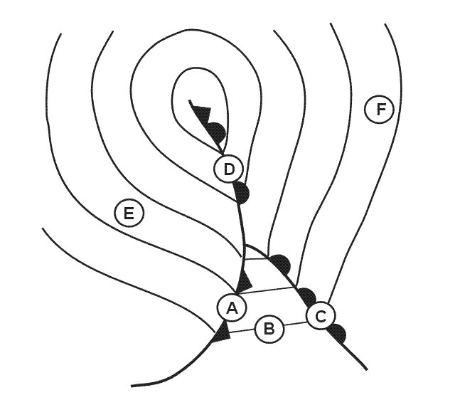
Question 154-32 : An aircraft is flying from point a to point b at the flight level corresponding to the pressure surface of the constant pressure chart which of the following statements is correct 387 ?
Wind speed over b is higher than over paris.
Ecqb01 2013The true altitude will be higher over b than over a. wind speed over a is higher than over b. the true altitude will be higher over b than over paris.
Question 154-33 : A temperature inversion indicates a state of the atmosphere which is ?
Question 154-34 : Which fl corresponds with the 150 hpa pressure level ?
Fl 450.
There is a few questions in the exam that take information directly from that table below write these down on a sticky and have them on the wall beside you 1013 hpa = msl850 hpa = fl50700 hpa = fl100500 hpa = fl180300 hpa = fl300200 hpa = fl390150 hpa = fl450any others you can interpolate between these and figure it outthe decrease of 1hpa27ft is only applicable at the lower levels of the troposphere as you go up and air pressure decreases the change of height per 1 hpa increases at msl 1hpa27ft at fl180 it's 50fthpa and at fl390 it's 105fthpa Fl 390. fl 340. fl 300.
Question 154-35 : In the icao standard atmosphere which of the following alternatives indicates the correct vertical temperature distribution in the lowest 11 km ?
15°c at mean sea level decreasing at 065°c per 100 metres.
Ecqb01 june 201313°c at mean sea level, decreasing at 2°c per 1000 feet. 15°c at mean sea level, decreasing at 0,65°c per 100 feet. 15,2°c at mean sea level, decreasing at 0,65°c per 100 metres.
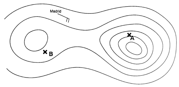
Question 154-36 : An aircraft is flying from point a to point b at the flight level corresponding to the pressure surface of the constant pressure chart which of the following statements is correct 390 ?
Wind speed over a is higher than over b.
Revised ecqb03 july 2016isobars are tighter at a than b so wind speed over a is higher than over bThe true altitude will be higher over a than over b. wind speed over b is higher than over a. the true altitude will be higher over a than over madrid.
Question 154-37 : Which constant pressure chart is standard for fl 450 ?
150 hpa.
Easa 2014there is a few questions in the exam that take information directly from that table below write these down on a sticky and have them on the wall beside you 1013 hpa = msl850 hpa = fl50700 hpa = fl100500 hpa = fl180300 hpa = fl300200 hpa = fl390150 hpa = fl450any others you can interpolate between these and figure it outthe decrease of 1hpa27ft is only applicable at the lower levels of the troposphere as you go up and air pressure decreases the change of height per 1 hpa increases at msl 1hpa27ft at fl180 it's 50fthpa and at fl390 it's 105fthpa 200 hpa. 250 hpa. 300 hpa.
Question 154-38 : What is meant by the term 'altitude' ?
The vertical distance of a level or a point measured from mean sea level.
Easa 2014The vertical distance of a level or a point measured from the earth's surface. altimeter indication when altimeter subscale is set to present qfe. the vertical distance of a level or a point measured from the aerodrome reference point.
Question 154-39 : Which fl corresponds with the 250 hpa pressure level ?
Fl 340.
Easa 2014there is a few questions in the exam that take information directly from that table below write these down on a sticky and have them on the wall beside you 1013 hpa = msl850 hpa = fl50700 hpa = fl100500 hpa = fl180300 hpa = fl300200 hpa = fl390150 hpa = fl450any others you can interpolate between these and figure it outthe decrease of 1hpa27ft is only applicable at the lower levels of the troposphere as you go up and air pressure decreases the change of height per 1 hpa increases at msl 1hpa27ft at fl180 it's 50fthpa and at fl390 it's 105fthpa Fl 390. fl 450. fl 300.
Question 154-40 : An aircraft flies at flight level 40 elevation of the aerodrome 990 ft qnh 976 hpathe tower clears the pilot to fly at 3000 ft qnhwhich of the following statements is correct ?
Only a small change of altitude is necessary.
Easa 2014aerodrome elevation is a irrelevantthe aircraft is at fl 40 referenced to 1013 hpa now it must fly at 3000 ft referenced to qnh of 976 hpathe difference is 37 hpa which at 27 ft per hpa = 999 ftso only a 1 ft change is needed hereThe aircraft has to descend about 2000 ft. the aircraft has to climb about 1000 ft. the aircraft has to descend about 1000 ft.
Exclusive rights reserved. Reproduction prohibited under penalty of prosecution.