A free Premium account on the FCL.055 website! Read here
Sign up to unlock all our services and 15164 corrected and explained questions.
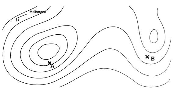
Question 155-1 : A surface based inversion is a characteristic of ? [ Learning aircraft ]
Nocturnal radiation during clear nights
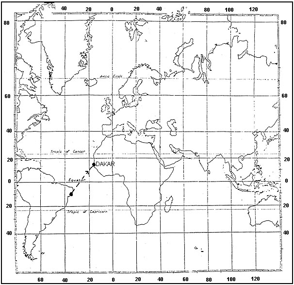
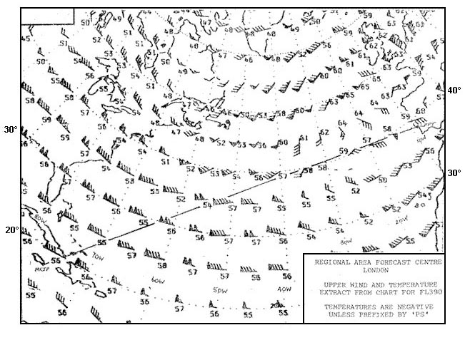
Question 155-2 : Flight from lisbon to kingstonconsidering the route segment between 30°w and 50°w at fl 390 the forecast mean temperature is 395 ?
56°c.
-59°c. -52°c. -61°c.
Question 155-3 : What is the approximate value of atmospheric pressure at 11000 m amsl in comparison to the atmospheric pressure at mean sea level ?
One fourth.
Ecqb03 july 2016One-half. one-eights. the same.
Question 155-4 : Which type of inversion can lead to fog formation due to the temperature of air in contact with the surface dropping below its dew point when it contacts a colder surface ?
Ground inversion.
Ecqb03 july 2016Frontal inversion turbulence inversion subsidence inversion
Question 155-5 : You are flying at fl 300 where the outside air temperature is 575°c and the pressure at msl is 101325 hpaif you assume that the difference between the actual temperature and the temperature in the isa is valid for the whole troposphere then the true altitude is ?
28500 ft.
Ecqb03 august 201630000 ft. 25000 ft. 31500 ft.
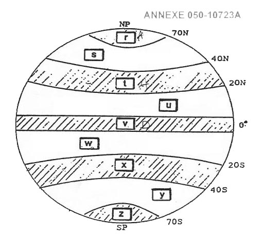
Question 155-6 : At what flight level is the zero degree isotherm at the equator ?
Fl 180.
the zero degree isotherm in the 'polar regions' is at ground level the zero degree isotherm in 'temperate regions' is at mean sea level in winters and at about 10000 feet in summers the zero degree isotherm in 'tropics' area 15° 30° n and s of the equator is at about 16000 feet the zero degree isotherm at the equator is at about 18000 ft fl180 Fl 150. fl 200. fl 250.
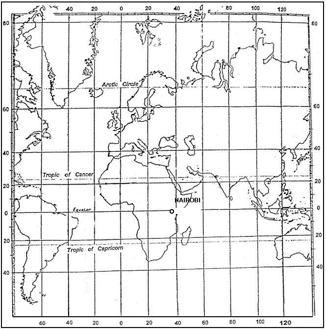
Question 155-7 : Why are polar regions colder than equatorial regions ?
Because the angle of incidence of the solar radiation is very small in polar regions.
Ecqb03 december 2016Because the angle of incidence of the solar radiation is very large in polar regions. the sky in the polar regions is cloud covered almost all the year. the polar regions stay in the dark almost all the year.
Question 155-8 : Which of the following is true concerning atmospheric pressure ?
It decreases with height.
The decrease of 1 hpa27ft is only applicable at the lower levels of the troposphere as you go up and air pressure decreases the change of height per 1 hpa increases at msl 1hpa27ft at fl180 it's 50fthpa and at fl390 it's 105fthpa It is higher in winter than in summer. it is higher at night than during the day. it always decreases with height at a rate of 1 hpa per 8m.
Question 155-9 : The vertical temperature gradient lapse rate in the international standard atmosphere isa is ?
65°c per 1000 m.
2°c per 1000 m. 3°c per 1000 m. 4.5°c per 1000 m.
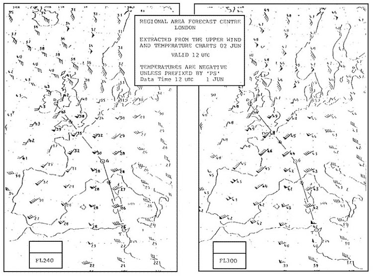
Question 155-10 : What is the approximate height of the tropopause between keflavik and helsinki 406 ?
Fl 320.
462you will find fl 325 closest answer is fl 320Fl 300. fl 360. fl 350.
Question 155-11 : For a flight from the azores to the bermudas the tropical tropopause is to be found at a height of approximately 409 ?
51000 ft 12000 metres .
60 000 ft (14000 metres). 39 000 ft (9000 metres). 33 000 ft (8000 metres).
Question 155-12 : Tropopause altitude at 38°n 19°w is 410 ?
Fl 320.
Fl 360. fl 420. fl 400.
Question 155-13 : Assuming a normal vertical temperature gradient at what altitude will the freezing level above shannon be found 411 ?
Fl 60.
Fl 20. fl 140. fl 120.
Question 155-14 : The temperature deviation from isa to the nearest °c overhead charleston at fl 340 is 419 ?
+5.
The temperature lapse rates of the troposphere is mean value 065°c100 m or 2°c1000 ftin isa temperature at fl340 should be 15 + 34 x 2°c = 53°cas the current temperature at that level is 48°c you can say that at fl340 it is currently isa+5it is 5°c warmer than isa+3. -7. -5.
Question 155-15 : The maximum possible temperature at north pole is ?
Dependent on the seasons.
-10°c. +10°c. -20°c.
Question 155-16 : In the northern hemisphere the force that causes a deviation to the left from the surface wind relative to the geostrophic wind is ?
Frictional force.
Ecqb04 january 2018 498at the surface and at low elevations friction will slow the air and hence the coriolis will be less effective in its deflection of the windthe flow turns across the isobars you have more flow into the low pressure system giving convergence and feeding the convectionCentripetal force. pressure gradient. coriolis force.
Question 155-17 : The wind indicator for a weather observation receives the measured value from an anemometer where is this instrument placed ?
On a mast 8 10 m above the runway.
1 m above the runway. close to the station about 2 m above the ground. on the roof of the weather station.
Question 155-18 : The geostrophic wind is greater than the gradient wind around a low pressure system because the ?
Centrifugal force opposes the pressure gradient.
We have a geostrophic wind when the pressure gradient force pgf is exactly balanced by coriolis force 582it is only happens when isobars are straights and parallelsif the isobars are curved an additional force centrifugal force is introduced and always tries to throw the parcel of air outwards from the centre of its rotation and the resulting movement of air is called the gradient wind 583with an area of high pressure anticyclone the centrifugal force is acting in the same direction as pgf effectively increasing it coriolis balances the total force pgf + centrifugal force and the gradient wind is 'high round a high' ie for a given gap between the isobars the gradient wind is stronger than the geostrophic wind with an area of low pressure cyclonic system the centrifugal force is opposing the pgf effectively decreasing it coriolis balances the total force pgf centrifugal force and the gradient wind is 'low round a low' ie for a given gap between the isobars the gradient wind is weaker than the geostrophic wind Centrifugal force is added to the pressure gradient. coriolis force is added to the pressure gradient. coriolis force opposes to the centrifugal force.
Question 155-19 : The geostrophic wind is less than the gradient wind around an anticyclone because the ?
Centrifugal force is added to the pressure gradient.
We have a geostrophic wind when the pressure gradient force pgf is exactly balanced by coriolis force 582it is only happens when isobars are straights and parallelsif the isobars are curved an additional force centrifugal force is introduced and always tries to throw the parcel of air outwards from the centre of its rotation and the resulting movement of air is called the gradient wind 583with an area of high pressure anticyclone the centrifugal force is acting in the same direction as pgf effectively increasing it coriolis balances the total force pgf + centrifugal force and the gradient wind is 'high round a high' ie for a given gap between the isobars the gradient wind is stronger than the geostrophic wind with an area of low pressure cyclonic system the centrifugal force is opposing the pgf effectively decreasing it coriolis balances the total force pgf centrifugal force and the gradient wind is 'low round a low' ie for a given gap between the isobars the gradient wind is weaker than the geostrophic wind Centrifugal force opposes the pressure gradient. effect of coriolis is added to friction. coriolis effect opposes the centrifugal force.
Question 155-20 : In the lower layers of the atmosphere due to friction the wind changes direction towards the low pressure area because ?
Wind speed decreases and therefore coriolis force decreases.
498at low elevations friction will slow the air and hence the coriolis will be less effective in its deflection of the windThe pressure gradient increases. turbulence is formed and pressure increases. turbulence is formed and pressure decreases.
Question 155-21 : The most frequent wind direction in a valley caused by thermal effects is toward the ?
Mountain during daylight hours.
During the day the sun heats up valley air rapidly this causes it to rise causing a warm upslope wind valley breeze at night the process is reversed mountain air cools rapidly at night and 'falls' downslope causing a wind going in the valley mountain breeze 499a mountain breeze and a valley breeze are two related localized winds that occur one after the other on a daily cycleMountain at night. valley during daylight hours. valley during daylight as much as at night.
Question 155-22 : Convective activity over land in mid latitudes is greatest in ?
Summer in the afternoon.
Thunderstorms may occur in the summer months in the afternoon or evening due to convective activity the land warms causing convective lifting = cb Winter during the night and early morning. summer during the night and early morning. winter in the afternoon.
Question 155-23 : Which forces are balanced with geostrophic winds ?
Pressure gradient force coriolis force.
We have a geostrophic wind when the pressure gradient force pgf is exactly balanced by coriolis force 582Friction force, pressure gradient force, coriolis force. pressure gradient force, coriolis force, centrifugal force. pressure gradient force, centrifugal force, friction force.
Question 155-24 : How does moderate turbulence affect an aircraft ?
Changes in altitude or attitude occur but the aircraft remains in positive control at all times.
Procedures for air navigation services air traffic management pans atm doc 4444 instructions for air reporting by voice communicationsmoderate conditions in which moderate changes in aircraft attitude andor altitude may occur but the aircraft remains in positive control at all times usually small variations in airspeed changes in accelerometer readings of 05 g to 10 g at the aircraft's centre of gravity difficulty in walking occupants feel strain against seat belts loose objects move aboutsevere conditions in which abrupt changes in aircraft attitude andor altitude occur aircraft may be out of control for short periods usually large variations in airspeed changes in accelerometer readings greater than 10 g at the aircraft's centre of gravity occupants are forced violently against seat belts loose objects are tossed aboutRapid and somewhat rhythmic bumpiness is experienced without appreciable changes in altitude or attitude. large, abrupt changes in altitude or attitude occur but the aircraft may only be out of control momentarily. continued flight in this environment will result in structural damage.
Question 155-25 : Which degree of aircraft turbulence is determined by the following icao description 'there may be moderate changes in aircraft attitude andor altitude but the aircraft remains in positive control at all times usually small variations in air speed changes in accelerometer readings of 05 to 10 g at ?
Moderate.
Procedures for air navigation services air traffic management pans atm doc 4444 instructions for air reporting by voice communicationsmoderate conditions in which moderate changes in aircraft attitude andor altitude may occur but the aircraft remains in positive control at all times usually small variations in airspeed changes in accelerometer readings of 05 g to 10 g at the aircraft's centre of gravity difficulty in walking occupants feel strain against seat belts loose objects move aboutsevere conditions in which abrupt changes in aircraft attitude andor altitude occur aircraft may be out of control for short periods usually large variations in airspeed changes in accelerometer readings greater than 10 g at the aircraft's centre of gravity occupants are forced violently against seat belts loose objects are tossed aboutSevere. violent. light.
Question 155-26 : In a land and sea breeze circulation the land breeze blows ?
During the night and is weaker than the sea breeze.
600During the day and is stronger than the sea-breeze. during the day and is weaker than the sea-breeze. during the night and is stronger than the sea-breeze.
Question 155-27 : A high pressure area slack pressure gradient covers part of the mediterranean sea and coastal region during the summer what surface wind direction is likely at an airport at the coast on a sunny afternoon ?
Sea to land.
During a sunny afternoon sea breeze is likely to occur 601we should expect a wind from the sea 544Land to sea. variable. parallel to the coastline.
Question 155-28 : A mountain breeze katabatic wind blows ?
Down the slope during the night.
During the day the sun heats up valley air rapidly this causes it to rise causing a warm upslope wind valley breeze at night the process is reversed mountain air cools rapidly at night and falls downslope causing a wind going in the valley mountain breeze 499a mountain breeze and a valley breeze are two related localized winds that occur one after the other on a daily cycleUp the slope during the day. down the slope during the day. up the slope during the night.
Question 155-29 : Generally northern hemisphere winds at 5000 ftagl are south westerly while most of the surface winds are southerly what is the primary reason of difference between these two wind directions ?
Friction between the wind and the surface.
At low elevations friction will slow the air and hence the coriolis force will be less effective in its deflection of the wind 561as the elevation decreases the direction backs changes direction in an counter clockwise motion in northern hemisphereat mid latitude over land wind speed in friction layer decrease by 50% angle between wind direction and isobars changes by 30° value to be used in examinations A strong pressure gradient at higher altitudes. stronger coriolis force at the surface. the influence of warm air at the lower altitude.
Question 155-30 : Friction between the air and the ground results in the northern hemisphere in ?
Backing of the wind and decrease of wind speed at the surface.
At low elevations friction will slow the air and hence the coriolis force will be less effective in its deflection of the wind 561as the elevation decreases the direction backs changes direction in an counter clockwise motion in northern hemisphereat mid latitude over land wind speed in friction layer decrease by 50% angle between wind direction and isobars changes by 30° value to be used in examinations Veering of the wind and decrease of wind speed at the surface. backing of the wind and increase of wind speed at the surface. veering of the wind and increase of wind speed at the surface.
Question 155-31 : What degree of turbulence if any is likely to be encountered while flying through a cold front in the summer over central europe at fl 100 ?
Severe turbulence in cb cloud.
Moderate turbulence in ns cloud. light turbulence in cb cloud. light turbulence in st cloud.
Question 155-32 : You are flying at 2500 ftagl above ground level the wind is 180° and intend to land at an airport at sea level directly below from approximately which direction would you expect the surface wind mid latitude northern hemisphere ?
South southeast.
At low elevations friction will slow the air and hence the coriolis force will be less effective in its deflection of the windin northern hemisphere at mid latitude over land wind speed in friction layer decrease by 50% the wind in the friction layer blows across the isobars towards the low pressure angle between wind direction and isobars changes by 30° value to be used in examinations at 2500 ft you will be out of the friction layer on the ground the direction will be 180° 30° = 150° south southeast direction in the northern hemisphere the friction layer decreases the wind direction anti clockwiseSouth-southwest. southwest. south.
Question 155-33 : What units are used to report vertical wind shear ?
Kt100 ft.
Kt. m/100 ft. m/sec.
Question 155-34 : What name is given to the jet stream lying across india a 262 ?
Tropical jet stream.
Tropical jet stream = tropical easterly jet = equatorial jet stream = the only one blowing from east to west during summer season 533Polar front jet stream. arctic jet stream. sub-tropical jet stream.
Question 155-35 : An aircraft is flying through the polar front jet stream from south to north beneath the core how would the oat change in the northern hemisphere during this portion of the flight ?
It decreases.
The polar front jet stream runs from west to east and it will be found in the warm air of the ferrel cell sub tropical air mass 575if you cross below the jet stream northern hemisphere and you are flying from south to north then you are flying from the warm subtropical air into the colder polar airthe outside air temperature oat will decreaseIt increases. it first increases, then decreases. it remains constant.
Question 155-36 : What is the average height of the arctic jet stream core ?
20000 ft .
Average height of the arctic jet 20000 ftaverage height of the polar front jet 30000 ftthe artic jet is at a higher latitude than the polar front jet hence at a lower height tropopause is lower at the poles than the equator arctic jet stream = 20000 ftpolar front jet stream = 30000 ftsubtropical jet stream = 40000 ft30000 ft. 40000 ft. 50000 ft.
Question 155-37 : What is the approximate ratio between height and width for a jet stream cross section ?
Ratio is 1100.
For examination purposes we assume a jet stream to be about 2000 nm long 200 nm wide and 2 nm deep this gives an approximate ratio between height and width of 1100Ratio is 1/1. ratio is 1/10. ratio is 1/1000.
Question 155-38 : Which jet stream blows all year round over the northern hemisphere ?
The subtropical jet stream.
The subtropical and polar front jets are present throughout the yearthe polar night jet is only active during the winter months of the northern hemisphere and is located at 60° norththe equatorial jet is only present during the northern hemisphere summerThe polar night jet stream. the equatorial jet stream. the arctic jet stream.
Question 155-39 : What is the average height of the jet core within a polar front jet stream ?
30000 ft.
Arctic jet stream = 20000 ftpolar front jet stream = 30000 ftsubtropical jet stream = 40000 ft 59540000 ft. 50000 ft. 20000 ft.
Question 155-40 : An aircraft is flying from south to north above the polar front jet stream at fl 400 in the southern hemisphere what change if any in temperature will be experienced ?
It decreases.
Flying from south to north in the southern hemisphere means that on crossing the polar front the aircraft will go from the cold air mass polar maritime to the warm air mass tropical maritime at fl400 the aircraft will be above the tropopausethe tropopause in the warm air will be higher and colder than the tropopause in the cold air so the aircraft will note a decrease in temperatureIt increases. it stays the same. it decreases and then increases.
Exclusive rights reserved. Reproduction prohibited under penalty of prosecution.