A free Premium account on the FCL.055 website! Read here
Sign up to unlock all our services and 15164 corrected and explained questions.
Question 156-1 : A wind speed of 350 kt within a jet stream core should be world wide regarded as ? [ Learning aircraft ]
Possible but a very rare phenomenon
Question 156-2 : An aircraft over western europe is crossing a jet stream 2500 ft below its core at right angles while crossing the outside temperature is increasing the prevailing wind is ?
From the right.
If the outside temperature is increasing while crossing below its core it's because you are flying from cold sector to warm sectorthe wind comes from your right because if you stand with your back to the wind in northern hemisphere low pressure and low temperature are on your leftFrom the left. tailwind. headwind.
Question 156-3 : What is the main cause for the formation of a polar front jet stream ?
The north south horizontal temperature gradient at the polar front.
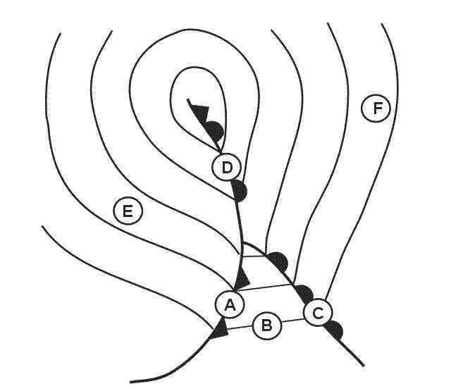
Fundamental to the formation of the polar front jet stream is the physical property that warm air is less dense than cold air when both are at the same pressure the polar front represents the boundary between higher latitude cold air and lower latitude warm air this temperature contrast extends from earth's surface up to the polar front jet stream altitudeair pressure is determined by the weight of overlying air in the vicinity of the polar front air pressure drops more rapidly with an increase in altitude in the more dense cold air than in the less dense warm airthe effect of temperature on air density results in air pressure at any given altitude being higher on the warm equatorward side of the polar front than on the cold poleward side when cold and warm air reside side by side the higher the altitude the greater the pressure difference is between the cold and warm air at the same altitudeacross the polar front at upper levels including the jet stream altitude horizontal pressure differences cause air to flow from the warm air side of the front towards the cold air side of the frontonce air is in motion it is deflected by earth's rotation coriolis effect upper level air flowing poleward from higher pressure towards lower pressure is deflected to the right in the northern hemisphere or to the left in the southern hemisphere the result is a jet stream flowing generally towards the east parallel to and above the polar frontThe pressure difference, close to the ground, between a high over the azores and a low over iceland. strong winds in the upper atmosphere. the varied elevations of the tropopause in the polar front region.
Question 156-4 : Which jet stream is connected with a surface front system ?
The polar front jet stream.
The polar front is the boundary between polar air and tropical air 595you can see that the polar front jet stream is connected with the polar front for the other jetstreams there is no front for information easterly jet stream is the equatorial jetstream The easterly jet stream. the subtropical jet stream. the equatorial jet stream.
Question 156-5 : At approximately what flight level is the subtropical jet stream found ?
Fl 400.
Jet streams vary in height from 20000 ft to 40000 ft and can reach speeds of more than 240 kt 595the subtropical jet stream is located around 30°nthe subtropical jet stream can be found at fl400 40000 ft arctic jet stream = 20000 ftpolar front jet stream = 30000 ftsubtropical jet stream = 40000 ftFl 150. fl 200. fl 500.
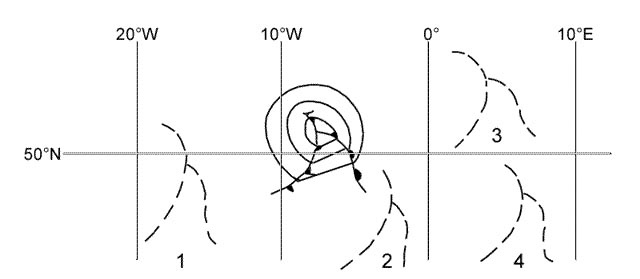
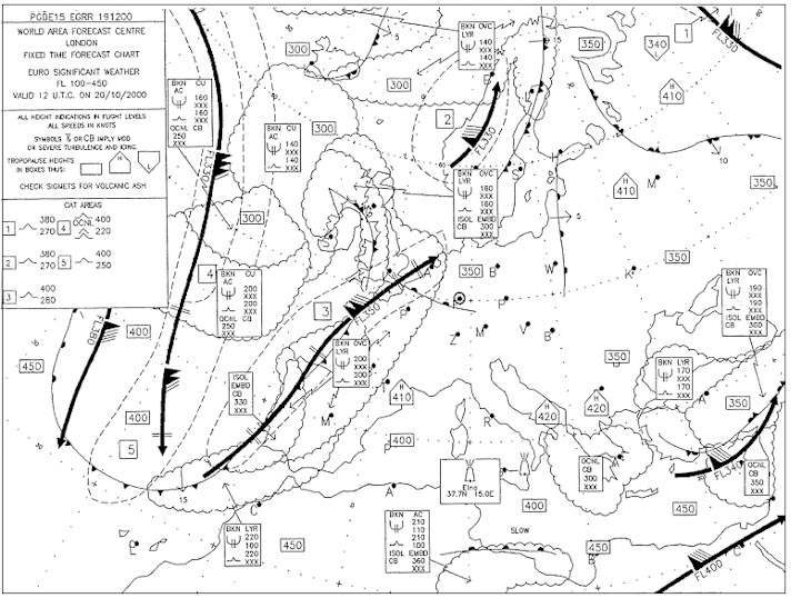
Question 156-6 : Flight zurich to rome etd 1600 utc eta 1800 utc at what flight level would you first expect to encounter clear air turbulence on the climb out from zurich 273 ?
Fl 220.
522cat area n°2 shows moderate cat between fl220 and fl400Fl 160. fl 320. fl 140.
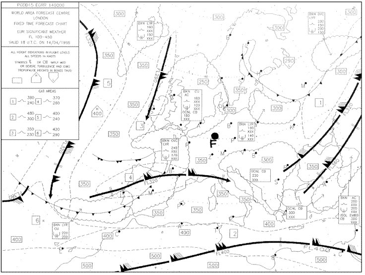
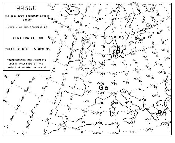
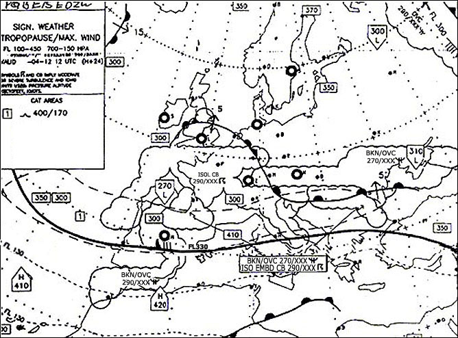
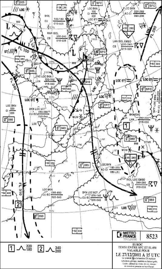
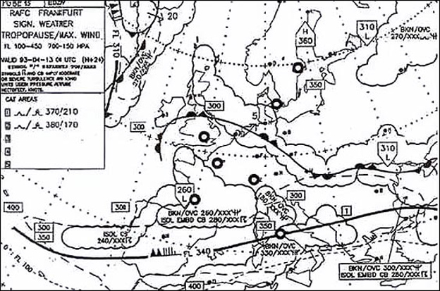
Question 156-7 : At what flight level is the jet stream core that is situated over northern scandinavia 274 ?
Fl 280.
525the jet stream flight level is indicated below his position maximum jet stream wind speed is 135 ktFl 330. fl 360. fl 300.
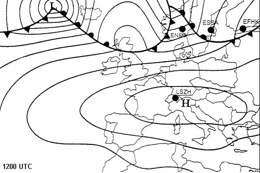
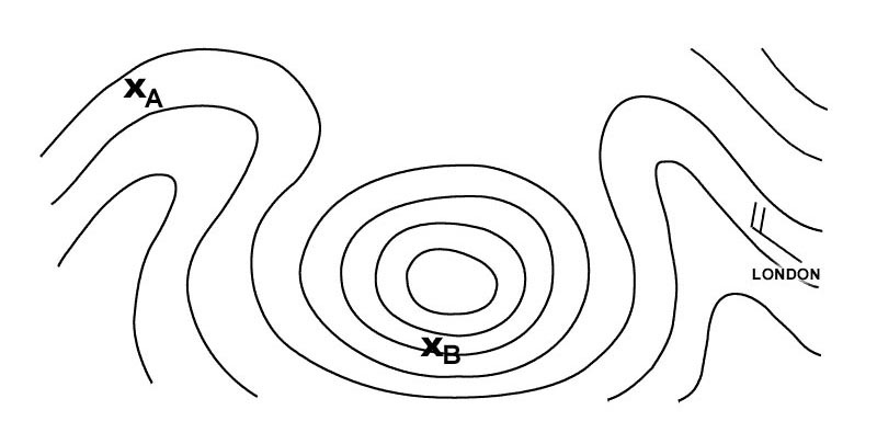
Question 156-8 : Select from the map the wind for the route zurich london at fl 280 277 ?
22060.
527225°95 kt220°55 kt210°40 kt255°35 ktaverage wind is 227°56 kt in northern hemisphere wind turns clockwise with height and speed increases it means that normally at fl280 chart is for fl300 we should expect a wind of 220°50 ktanyway answer 22060 remains the only valid answer250/80. 040/60. 160/90.
Question 156-9 : What name is given to the jet stream lying over north africa b 280 ?
Sub tropical jet stream.
The subtropical jet stream is located around 30°ns 590Equatorial jet stream. polar front jet stream. arctic jet stream.
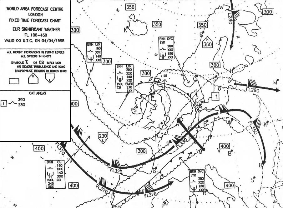
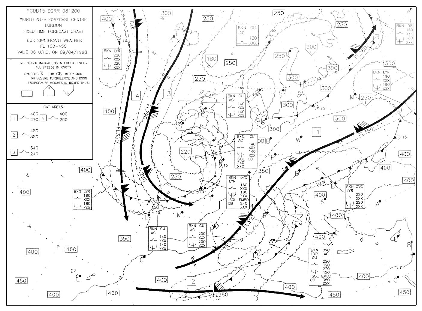
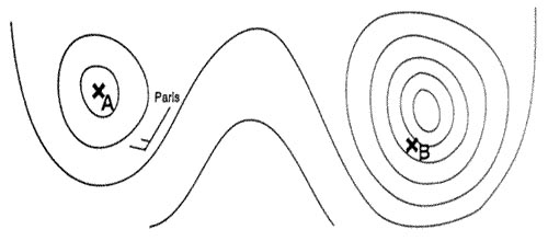
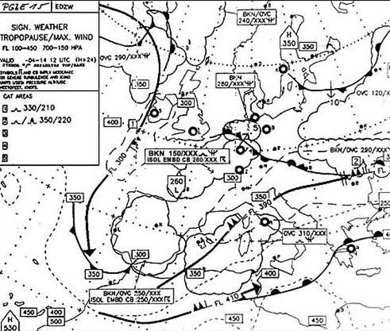
Question 156-10 : What wind is forecast at fl 390 over paris 281 ?
210°40 kt.
528the wind is blowing with a south south west component west of paris and speed is reducing from 45 kt to 30 kt close to luxembourg '210°40 kt' is the correct answer240°/20 kt. 030°/40 kt. 190°/40 kt.
Question 156-11 : What is the direction and maximum speed of the jet stream affecting the route between munich and london 285 ?
220° 120 kt.
529050° / 120 km/h. 050° / 120 kt. 230° / 120 m/sec.
Question 156-12 : Flight from bordeaux to amsterdam eta 2100 utc at eta amsterdam what surface wind is forecast taf eham 281500z 281601 14010kt 6000 ra sct025 becmg 1618 12015g25kt sct008 bkn013 tempo 1823 3000 ra bkn005 ovc010 becmg 2301 25020kt 8000 nsw bkn020 = ?
120° 15 kt gusts 25 kt.
Becmg becoming indicates a change to forecast conditions is expected to occur slowly within the period designated in the time group immediately following the headingthe duration of this change is normally about 2 hours the elements included in the becmg line will supercede some of the previous taf groups but it is possible all the groups may changeany group omitted in the becmg line will be the same during the becmg period as indicated in the main taf linein this question the wind becoming 120°15 kt gusts 25 kt 12015g25kt between 16h and 18h it will remain unchanged until 23hthen the wind becoming 250°20kt between 23h and 01h250° / 20 kt. 140° / 10 kt. 300° / 15 kt maximum wind 25 kt.
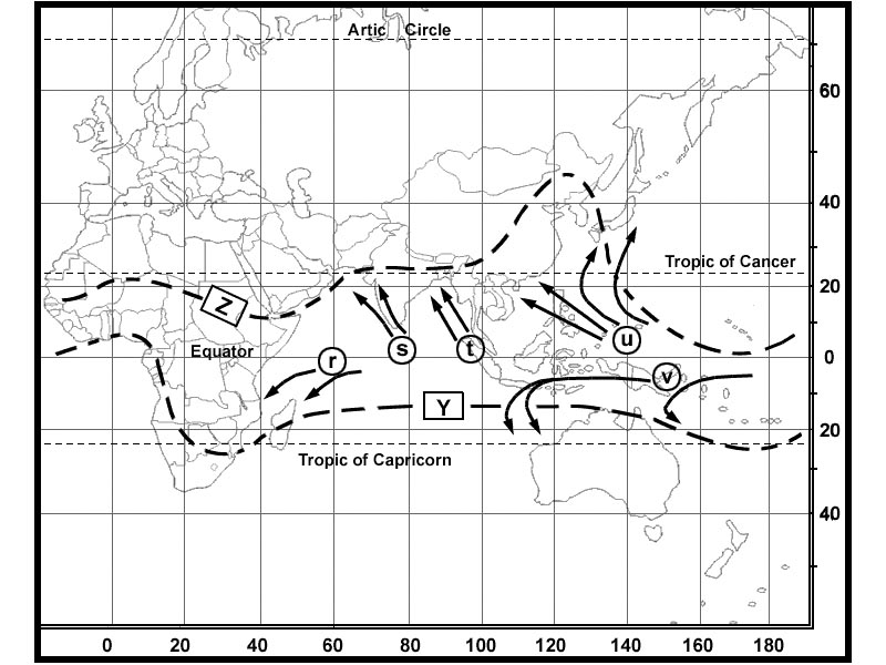
Question 156-13 : The equatorial easterly jet is a jet stream that occurs ?
Only in the summer of the northern hemisphere at approximately 45 000 ft.
This jet occurs in the northern summer between 10°n and 20°n chiefly over or just to the south of high land masses such as in asia and africa its occurrence is due to a temperature gradient with colder air to the south which produces sufficient temperature differential above 45000 ft to give wind speeds of over 100 ktbecause colder temperatures at height are to the south it is an easterly jet this jet is now more usually known as the tropical easterly jet perhaps more correctly as it lies some distance from the equator 533Only in the winter of the northern hemisphere at approximately 30 000 ft. during the whole year in the southern hemisphere. during the whole year in the northern hemisphere.
Question 156-14 : In which zone of a polar front jet stream is the strongest cat to be expected ?
On the polar air side of the core.
The strongest cat is in the warm tropical air but on the cold polar air side of the coreOn the tropical air side of the core. exactly in the centre of the core. about 12000 ft above the core.
Question 156-15 : What is the minimum speed for a wind to be classified as a jet stream ?
60 kt.
The heavyline line delineating the jet axis beginsends at the points where a wind speed of 30 ms 60 kt is forecast50 kt. 70 kt. 100 kt.
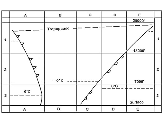
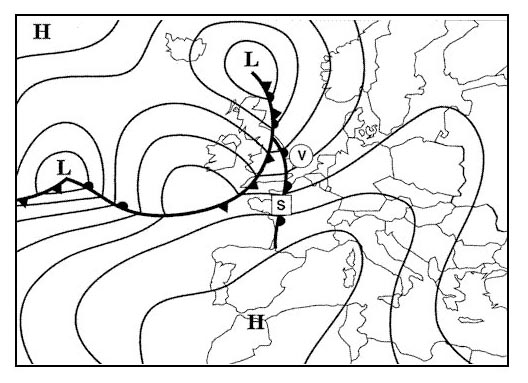
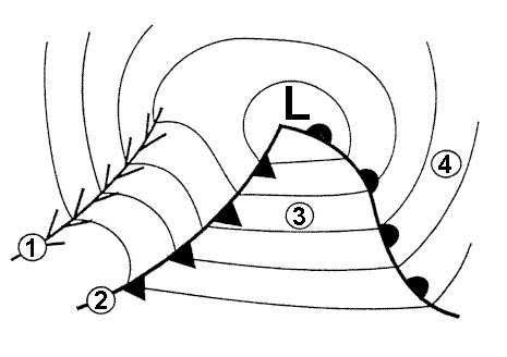
Question 156-16 : A wind sounding in the region of a polar front jet stream gives the following windprofile northern hemisphere 900hpa 22020kt800hpa 22025kt700hpa 23035kt500hpa 26060kt400hpa 28085kt300hpa 300100kt250hpa 310120kt200hpa 31080ktwhich system is the jet stream associated with ?
With a warm front.
The highest wind speed is in the core of the polar front jet stream at 250 hpa approximately fl340 in the northern hemisphere the cold front jet is from the sw and the warm front jet is from the nwat fl340 the jet direction is 310° it is a north west directionWith a cold front. with a itcz. with an easterly wave.
Question 156-17 : What is the most significant difference between an equatorial jet stream and all the other jet streams ?
Wind direction.
Its wind direction is from east to westthis jet occurs in the northern summer between 10°n and 20°n chiefly over or just to the south of high land masses such as in asia and africabecause colder temperatures at height are to the south it is an easterly jet this jet is now more usually known as the tropical easterly jet perhaps more correctly as it lies some distance from the equator 533Vertical dimension. horizontal dimension. wind speed.
Question 156-18 : You cross a jet stream in horizontal flight at approximately right angles while crossing in spite of a strong wind of 120 kt you notice the temperature barely changes which of the following statements is correct ?
This phenomenon is absolutely normal as you are crossing the jet core.
You assume the front associated with the jet stream to be very weak with practically no temperature difference between the two air masses. since the result of such readings seems impossible, you will have the instruments tested after landing. this phenomenon does not surprise you at all, since normally no large temperature differences are possible at these heights.
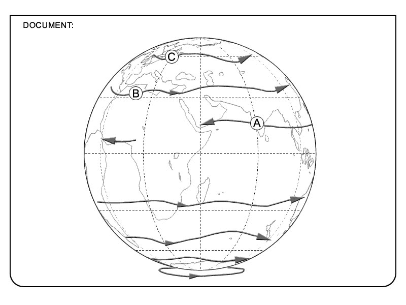
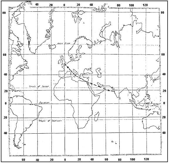
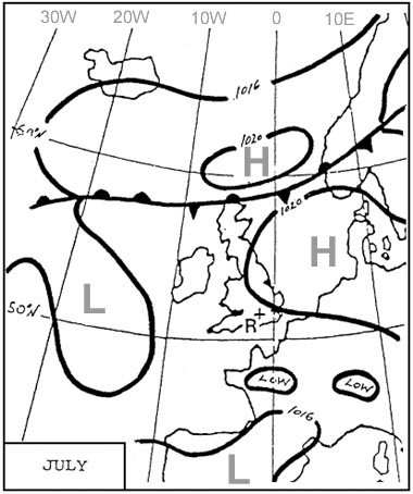
Question 156-19 : What jet streams are likely to be crossed during a flight from stockholm to rio de janeiro 23°s at fl 350 in july ?
A polar front jet stream followed by one or two subtropical jet streams.
2535A subtropical jet stream followed by a polar front jet stream. a polar front jet stream followed by a subtropical jet stream and later, a second polar front jet stream. one subtropical jet stream.
Question 156-20 : While crossing a jet stream at right angles in western europe 3000 ft below its core and oat is decreasing what would be the prevailing wind ?
Crosswind from the left.
If you are moving to an area of decreasing temperature then you must be moving from an area of warm air to cold and in the northern hemisphere the frontal jetstream which is just underneath the warm sector tropopause in the warm sector close to the front blows with the cold sector to its left therefore if you are crossing to the cold sector the jet is blowing from the left 595Crosswind from the right. a headwind. a tailwind.
Question 156-21 : During the winter months in mid latitudes in the northern hemisphere the polar front jet stream moves toward the ?
South and speed increases.
In winter the polar front moves south 585during summer it moves north 598winter speed 130 to 150 ktsummer speed 60 to 100 ktNorth and speed decreases. south and speed decreases. north and speed increases.
Question 156-22 : What causes surface winds to flow across the isobars at an angle rather than parallel to the isobars ?
Surface friction.
Friction is a force it is a force that slows motion and dampens energyin meteorology friction is important because it causes the wind speeds at the surface to be less and more turbulent than they otherwise would be rough terrain is more effective in decreasing the wind speed than a water surface friction processes can help promote surface convergence and upliftresistance to movement of air flowing along the surface of the earth induces the wind to flow across the isobars at an angleCoriolis force. greater density of the air at the surface. greater atmospheric pressure at the surface.
Question 156-23 : What prevents air from flowing directly from high pressure areas to low pressure areas ?
Coriolis force.
Pressure gradient tries to move air from high pressure to low pressure but coriolis force deflects it to the right in the northern hemisphere and to the left in the southern hemisphereSurface friction. katabatic force. the pressure gradient force.
Question 156-24 : What is the approximate speed of a 25 knot wind expressed in kilometres per hour ?
45 kmh.
1 kt = 1852 kmhuse this formula 25 kt x 2 10% = 45 kmh35 km/h. 55 km/h. 60 km/h.
Question 156-25 : What is the approximate speed of a 90 kmh wind expressed in knots ?
50 kt.
1 kt = 1852 kmhuse this formula 90 kmh + 10% 2 = 495 kt55 kt. 60 kt. 70 kt.
Question 156-26 : What is the approximate speed of a 40 knot wind expressed in msec ?
Question 156-27 : Where in central europe are the highest wind speeds to be found ?
Just below the tropopause.
The strongest winds in this area are the polar front jetstreams which are just below the warm air tropopauseClose to the ground. at about 5500 metres altitude. in the stratosphere.
Question 156-28 : If paris reports a wind of 19015kt on the metar what wind velocity would you expect to encounter at a height of 2000 feet above the ground ?
22030 kt.
values to be used in examinations over sea wind speed in friction layer decrease by 30% the wind in the friction layer blows across the isobars towards the low pressure angle between wind direction and isobars changes by 10°over land wind speed in friction layer decrease by 50% the wind in the friction layer blows across the isobars towards the low pressure angle between wind direction and isobars changes by 30°16020 kt 25025 kt 22010 kt
Question 156-29 : If paris reports a wind of 08010kt on the metar what wind velocity would you expect to encounter at a height of 2000 feet above the ground ?
11020kt.
values to be used in examinations over sea wind speed in friction layer decrease by 30% the wind in the friction layer blows across the isobars towards the low pressure angle between wind direction and isobars changes by 10°over land wind speed in friction layer decrease by 50% the wind in the friction layer blows across the isobars towards the low pressure angle between wind direction and isobars changes by 30°08015kt 05020kt 08005kt
Question 156-30 : If paris reports a wind of 16020kt on the metar what wind velocity would you expect to encounter at a height of 2000 feet above the ground ?
19040kt.
values to be used in examinations over sea wind speed in friction layer decrease by 30% the wind in the friction layer blows across the isobars towards the low pressure angle between wind direction and isobars changes by 10°over land wind speed in friction layer decrease by 50% the wind in the friction layer blows across the isobars towards the low pressure angle between wind direction and isobars changes by 30°16030kt 14020kt 17015kt
Question 156-31 : If paris reports a wind of 30012kt on the metar what wind velocity would you expect to encounter at a height of 2000 feet above the ground ?
33025kt.
values to be used in examinations over sea wind speed in friction layer decrease by 30% the wind in the friction layer blows across the isobars towards the low pressure angle between wind direction and isobars changes by 10°over land wind speed in friction layer decrease by 50% the wind in the friction layer blows across the isobars towards the low pressure angle between wind direction and isobars changes by 30°23030kt 30025kt 27020kt
Question 156-32 : Which of the following is true of a land breeze ?
It blows from land to water.
Land breeze during the night land is cold sea is warm 600during the day the situation reverses and the wind will blow from the sea sea breeze 601It blows from water to land. it blows by day. it blows only at noon.
Question 156-33 : An aircraft is approaching under visual flight rules an airfield whose runway is parallel to the coast when downwind over the sea the airfield is on the right what wind effect should be anticipated on final approach and landing during a sunny afternoon ?
Crosswind from the right.
During a sunny afternoon sea breeze is likely to occur 601if the coast and runway are aligned eastwest a right hand circuit would mean runway 27 in use sea to the north and land to the southat touch down the northerly sea breeze would be from the rightCrosswind from the left. tailwind. headwind.
Question 156-34 : An aircraft is approaching under visual flight rules an airfield northern hemisphere whose runway is parallel to the coast when downwind over the sea the airfield is on the leftwhat wind effect should be anticipated on final approach and landing during a sunny afternoon ?
Crosswind from the left.
During a sunny afternoon sea breeze is likely to occur 601we should expect a crossing from the left on final approach and landing 544Headwind. tailwind. crosswind from the right.
Question 156-35 : When will the surface wind in a metar record a gust factor ?
When gusts are at least 10 knots above the mean wind speed.
When gusts are at least 15 knots above the mean wind speed. with gusts of at least 25 knots. with gusts of at least 35 knots.
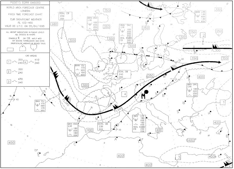
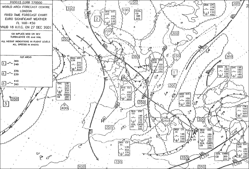
Question 156-36 : Select from the map the average wind for the route zurich rome at fl110 303 ?
23010.
548a feather corresponds to 10 ktif you look at the wind close to rome it comes approximately from 235°average wind is 230°10 kt200/30. 040/10. 250/20.
Question 156-37 : Select from the map the average wind for the route athens geneva at fl 160 304 ?
24040.
On the chart we find an average wind of 245° ==> 240+235+245+255 4this chart is for flight level 180 and they ask the average wind at fl160 thus the wind will be less than 245° northern hemisphere we find a wind speed of 4625 kt wind force will also be less only one answer remains correct 24040 484210/25. 260/40. 050/35.
Question 156-38 : Select from the map the average wind for the route zurich hamburg at fl 240 305 ?
23020.
On the left of zurich we notice a wind of 200°20 kton the right of zurich the wind is from 250°25 ktthe average wind will be 230°20 kt020/20. 200/15. 260/25.
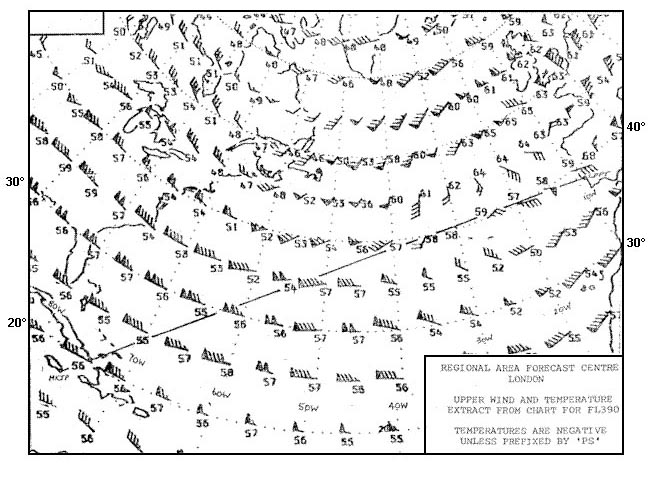
Question 156-39 : Select from the map the average wind for the route shannon lisboa at fl 290 306 ?
36080.
551the wind comes clearly from the north at a speed of 70 + 90 + 90 + 85 + 80 5 = 83 ktthe map is for fl300 the speed at fl290 will be slower than 83 kt030/70. 190/75. 340/90.
Question 156-40 : When otherwise calm and clear conditions exist a station on the shore of a large body of water will experience wind ?
From the water in daytime and from the land at night.
Land breeze during the night land is cold sea is warm 600during the day the situation reverses and the wind will blow from the sea sea breeze 601Continually from land to water. continually from water to the land. from the land in daytime and from the water at night.
Exclusive rights reserved. Reproduction prohibited under penalty of prosecution.