A free Premium account on the FCL.055 website! Read here
Sign up to unlock all our services and 15164 corrected and explained questions.
Question 157-1 : The greater the pressure gradient the ? [ Learning aircraft ]
Closer the isobars and the stronger the wind
Question 157-2 : When isobars for an area in the mid latitudes on a weather map are close together the wind is most likely to be ?
Strong.
Changing direction rapidly. blowing perpendicular to the isobars. light.
Question 157-3 : In the northern hemisphere a pilot flying at 1000 ft above ground level directly towards the centre of a low pressure area will find the wind blowing from ?
Left and behind.
In northern hemisphere wind flows counter clockwise around a low 573the wind blowing from left and behindRight and behind. about 45 degrees to the right of directly ahead. directly ahead.
Question 157-4 : In the northern hemisphere the wind at the surface blows ?
Counter clockwise around and toward the centre of a low pressure area.
In the northern hemisphere the wind is counter clockwise around low pressure and the effect of surface friction will make the wind 'back and slack' in the northern hemisphereFrom a low pressure area to a high pressure area clockwise around, and away from the centre of, a low pressure area counter-clockwise around, and away from the centre of, a high pressure area.
Question 157-5 : Wind is caused by ?
Horizontal pressure differences.
The rotation of the earth friction between the air and the ground the movements of fronts
Question 157-6 : During a descent from 2000 ft above the surface to the surface no frontal passage northern hemisphere the wind normally ?
Backs and decreases.
At low elevations friction will slow the air and hence the coriolis force will be less effective in its deflection of the wind 561when entering in the friction layer at about 2000 ft above the surface as the elevation decreases the direction backs changes direction in an counter clockwise motion in northern hemisphereat mid latitude over land wind speed in friction layer decrease by 50% angle between wind direction and isobars changes by 30° value to be used in examinations Veers and increases. backs and increases. veers and decreases.
Question 157-7 : The foehn wind is a ?
Warm katabatic wind.
Katabatic wind from the greek katabaino to go down is the generic term for downslope winds flowing from high elevations of mountains plateaus and hills down their slopes to the valleys or planes below katabatic winds exist in many parts of the world and there are many different names for katabatic winds depending where they are located and how they are formedwarm dry katabatic winds occur on the lee side of a mountain range situated in the path of a depression examples for these descending adiabatically warmed katabatic winds are the foehn windsCold katabatic wind. warm anabatic wind. cold anabatic wind.
Question 157-8 : The sea breeze is a wind from the sea ?
Occurring only in the lower layers of the atmosphere in daytime.
That reaches up to the tropopause in daytime blowing at night in mid-latitudes occurring only in mid-latitudes and in daytime
Question 157-9 : Geostrophic wind is the wind when isobars are ?
Straight lines and no friction is involved.
We have a geostrophic wind when the pressure gradient force pgf is exactly balanced by coriolis force 582it is only happens when isobars are straights and parallelsif the isobars are curved an additional force centrifugal force is introduced and always tries to throw the parcel of air outwards from the centre of its rotation and the resulting movement of air is called the gradient wind 583with an area of high pressure anticyclone the centrifugal force is acting in the same direction as pgf effectively increasing it coriolis balances the total force pgf + centrifugal force and the gradient wind is 'high round a high' ie for a given gap between the isobars the gradient wind is stronger than the geostrophic wind with an area of low pressure cyclonic system the centrifugal force is opposing the pgf effectively decreasing it coriolis balances the total force pgf centrifugal force and the gradient wind is 'low round a low' ie for a given gap between the isobars the gradient wind is weaker than the geostrophic wind Curved lines and no friction is involved straight lines and friction is involved. curved lines and friction is involved.
Question 157-10 : What relationship exists between the wind at 3000 feet and the surface wind ?
The wind at 3000 feet is parallel to the isohypses and the surface wind direction is across the isobars toward the low pressure and the surface wind is weaker.
They have the same direction, but the surface wind is weaker, caused by friction. they are practically the same, except when eddies exist, caused by obstacles. the surface wind is veered compared to the wind at 3000 feet and is usually weaker.
Question 157-11 : The wind tends to follow the contour lines isohypses above the friction layer because ?
The coriolis force tends to balance with the horizontal pressure gradient force.
We have a geostrophic wind when the pressure gradient force pgf is exactly balanced by coriolis force 582it is only happens when isobars are straights and parallelsif the isobars are curved an additional force centrifugal force is introduced and always tries to throw the parcel of air outwards from the centre of its rotation and the resulting movement of air is called the gradient wind 583with an area of high pressure anticyclone the centrifugal force is acting in the same direction as pgf effectively increasing it coriolis balances the total force pgf + centrifugal force and the gradient wind is 'high round a high' ie for a given gap between the isobars the gradient wind is stronger than the geostrophic wind with an area of low pressure cyclonic system the centrifugal force is opposing the pgf effectively decreasing it coriolis balances the total force pgf centrifugal force and the gradient wind is 'low round a low' ie for a given gap between the isobars the gradient wind is weaker than the geostrophic wind Contour lines are lines that connect points with the same wind speed in the upper air. the coriolis force acts perpendicular on a line that connects high and low pressure system. the friction of the air with the earth's surface gives the airflow a diversion perpendicular to the gradient force.
Question 157-12 : The wind speed in a system with curved isobars compared to a system with straight isobars is other conditions remain the same ?
Higher if curvature is anticyclonic.
We have a geostrophic wind when the pressure gradient force pgf is exactly balanced by coriolis force 582it is only happens when isobars are straights and parallelsif the isobars are curved an additional force centrifugal force is introduced and always tries to throw the parcel of air outwards from the centre of its rotation and the resulting movement of air is called the gradient wind 583with an area of high pressure anticyclone the centrifugal force is acting in the same direction as pgf effectively increasing it coriolis balances the total force pgf + centrifugal force and the gradient wind is 'high round a high' ie for a given gap between the isobars the gradient wind is stronger than the geostrophic wind with an area of low pressure cyclonic system the centrifugal force is opposing the pgf effectively decreasing it coriolis balances the total force pgf centrifugal force and the gradient wind is 'low round a low' ie for a given gap between the isobars the gradient wind is weaker than the geostrophic wind Always higher. always lower. higher if curvature is cyclonic.
Question 157-13 : The geostrophic wind depends on ?
Density earth's rotation geographic latitude.
To have a geostrophic wind we need to have a pressure gradient force create by density and coriolis force create by earth's rotation and depending on geographic latitude why density we need to have two differents air mass to have a pressure gradient force pgf 564why earth's rotation and geographic latitude since the earth rotates objects that are above the earth apparently move or are deflected if they are already moving owing to it's rotation this apparent motion is caused by the coriolis forcein the northern hemisphere objects will be deflected to their right while in the southern hemisphere objects will be deflected to their leftthe magnitude of the deflection is also a function of distance from the equator and velocity so the farther from the equator the object is the greater the deflection and the faster an object is moving the greater the deflection these 'objects' can be anything from airplanes to birds to missiles to parcels of air 565the effect of the coriolis force for various latitudes 566Earth's rotation, geographic latitude, centripetal force. geographic latitude, centripetal force, height. centripetal force, height, pressure gradient.
Question 157-14 : In a mountain valley wind circulation the mountain wind blows ?
At night down from the mountains.
During the day the sun heats up valley air rapidly this causes it to rise causing a warm upslope wind valley breeze at night the process is reversed mountain air cools rapidly at night and 'falls' downslope causing a wind going in the valley mountain breeze 499a mountain breeze and a valley breeze are two related localized winds that occur one after the other on a daily cycleAt night up from the valley. during the day down from the mountains. during the day up from the valley.
Question 157-15 : Ahead of a warm front in northern hemisphere the wind direction changes from the surface up to the tropopausethe effect of this change is that the wind ?
Veers in the friction layer and veers above the friction layer.
567ahead of a warm front in northern hemisphere as ahead of a cold front the wind veers in the friction layer and veers above the friction layerwe know that the wind turns counterclockwise around a low pressure but for an observer on the ground looking at the front the wind veers turn clockwise at his positionBacks in the friction layer and veers above the friction layer. veers in the friction layer and backs above the friction layer. backs in the friction layer and backs above the friction layer.
Question 157-16 : The difference between geostrophic wind and gradient wind is caused by ?
Curvature of isobars.
We have a geostrophic wind when the pressure gradient force pgf is exactly balanced by coriolis force 582it is only happens when isobars are straights and parallelsif the isobars are curved an additional force centrifugal force is introduced and always tries to throw the parcel of air outwards from the centre of its rotation and the resulting movement of air is called the gradient wind 583with an area of high pressure anticyclone the centrifugal force is acting in the same direction as pgf effectively increasing it coriolis balances the total force pgf + centrifugal force and the gradient wind is 'high round a high' ie for a given gap between the isobars the gradient wind is stronger than the geostrophic wind with an area of low pressure cyclonic system the centrifugal force is opposing the pgf effectively decreasing it coriolis balances the total force pgf centrifugal force and the gradient wind is 'low round a low' ie for a given gap between the isobars the gradient wind is weaker than the geostrophic wind Friction. horizontal temperature gradients. slope of pressure surfaces.
Question 157-17 : During periods of prolonged clear skies associated with anticyclonic conditions the ?
Surface wind speed tends to be highest during the early afternoon.
Anticyclonic conditions indicate a high pressure system is presentwith a high pressure system and clear skies present we expect higher temperatures and these are at their highest during the afternoonas the temperature near the surface increases the air density decreases and so the effect of surface friction is lessened and wind speed is allowed to pick upSurface wind speed tends to be highest at night. angle between isobars and surface wind direction tends to be greatest in the early afternoon. wind tends to back from early morning until early afternoon.
Question 157-18 : The geostrophic wind speed is directly proportional to the ?
Horizontal pressure gradient.
The speed of a geostrophic wind calculated from the pressure gradient air density rotational velocity of the earth and latitude the calculation ignores the curvature of the wind's path a geostrophic wind is proportional to the pressure gradient or inversely proportional to the distance between the isobars 568winds exist because of horizontal and vertical pressure gradient so atmospheric motion can be deduced from isobaric surface charts etc if the horizontal pressure gradient force is exactly balanced in magnitude by coriolis effect accelerations of the air will be relatively small and a geostrophic wind will flow horizontally at a constant speed proportional to the isobaric spacing gradient perpendicular to the two opposing forces and parallel to straight isobars thus geostrophic wind speed is proportional to the pressure gradient the closer the isobars the higher will be geostrophic wind speedCurvature of isobars. sine of latitude. density of the air.
Question 157-19 : A strong dry and warm downslope wind produced by prior enforced ascent of air over hills or mountains is known as a ?
Foehn.
Scirocco. mistral. bora.
Question 157-20 : Geostrophic wind ?
Is perpendicular to the horizontal pressure gradient force.
We have a geostrophic wind when the pressure gradient force pgf is exactly balanced by coriolis force 582it is only happens when isobars are straights and parallelsthe geostrophic wind yellow arrow is perpendicular to the horizontal pressure gradient force pgf and to the coriolis forceIs directly proportional to the density of the air. always increases with increasing height. veers with height if cold air is advected in the northern hemisphere.
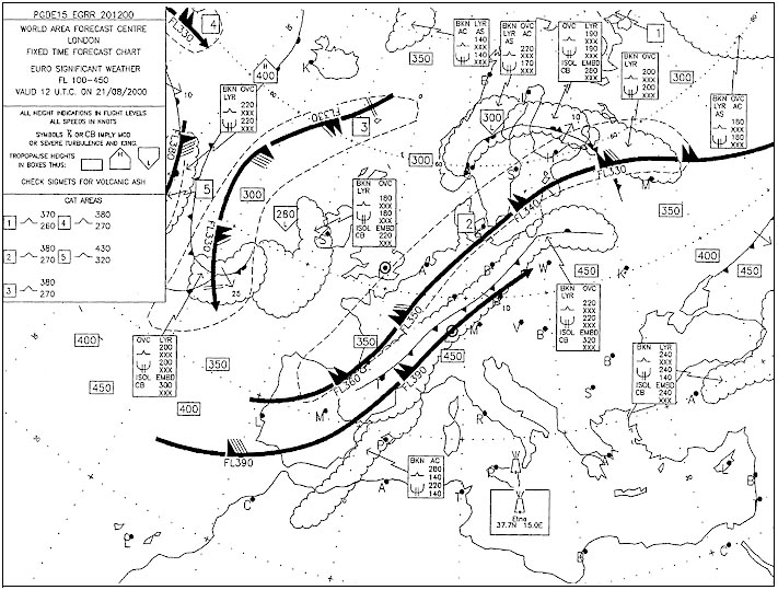
Question 157-21 : Which of the following statements concerning jet streams is correct ?
In the northern hemisphere both westerly and easterly jet streams occur.
In the northern hemisphere both westerly and easterly jet streams occur 533the tropical easterly jet stream blows only during summer from south east asia extending over southern india to central africaIn the northern hemisphere only westerly jet streams occur. in the southern hemisphere no jet streams occur. in the southern hemisphere only easterly jet streams occur.
Question 157-22 : Under which of the following conditions is the most severe cat likely to be experienced ?
A curved jet stream near a deep trough.
572a curving jet stream associated with a deep low pressure trough can be expected to cause great turbulenceA jet stream, with great spacing between the isotherms. a westerly jet stream at low latitudes in the summer. a straight jet stream near a low pressure area.
Question 157-23 : Above and below a low level inversion the wind is likely to ?
Change significantly in speed and direction.
A low level inversion means that a temperature inversion forms near the surface the airstream flowing over ground or water produces a turbulent layer the friction layer up to 500 feet deep in light winds or 3000 feet plus in strong windsthe wind above the inversion often increases because it is insulated from the frictional influence of the surface 574above and below a low level inversion the wind is likely to change significantly in speed and directionChange in speed but not in direction. change in direction but not in speed. experience little or no change in speed and direction.
Question 157-24 : Which of the following statements concerning the core of a polar front jet stream is correct ?
It lies at a height where there is no horizontal temperature gradient the slope of the pressure surfaces at the height of the core is at its maximum.
637the polar front jet core is in the warm air but above the cold air tropopause at a point where the temperature in the warm air troposphere is the same as the cold air stratosphere if the cold tropopause is 40°c then above that point in the cold sector the temperature is constant in the warm air at the same level as the cold tropopause the temperature will be warmer say 34°c but will decrease with altitudeat the point where the temperature in the warm air is the same as the 40°c in the cold air stratosphere you will find the strongest wind speedIt and its surface projection lie in the warm air. it lies in the warm air, its pressure surfaces are horizontal at the height of the core. it lies in the cold air, the wind reverses direction at the height of the core.
Question 157-25 : On a particular day part of a polar front jet stream runs from north to south in the northern hemisphere this means that ?
The polar air is below and to the east of the core of the jet.
Normaly the polar front jet stream runs from west to east and it will be found in the warm air of the ferrel cell sub tropical air mass 575now let's assume the direction is north to south polar front jet remains in warm air above the cold airthe polar air remains below and to the east of the core of the jetThe polar air is on the eastern side and above the core of the jet. below the core of the jet the horizontal temperature gradient runs from north to south. above the core of the jet the horizontal temperature gradient runs from north to south.
Question 157-26 : For a similar pressure gradient the geostrophic wind speed will be ?
Greater at 30°n than at 60°n.
To have a geostrophic wind we need to have a pressure gradient force and coriolis force create by earth's rotation and depending on geographic latitude we need to have two differents air mass to have a pressure gradient force pgf 564since the earth rotates objects that are above the earth apparently move or are deflected if they are already moving owing to it's rotation this apparent motion is caused by the coriolis forcein the northern hemisphere objects will be deflected to their right while in the southern hemisphere objects will be deflected to their leftthe magnitude of the deflection is also a function of distance from the equator and velocity so the farther from the equator the object is the greater the deflection and the faster an object is moving the greater the deflectionthese 'objects' can be anything from airplanes to birds to missiles to parcels of air 565the effect of the coriolis force for various latitudes 566we can see that coriolis force is maximum at high latitudes and minimum at the equatorwe can deduce that for a similar pressure gradient the geostrophic wind speed will be greater at 30°n than at 60°nGreater at 60°n than at 30°n. the same at all latitudes north or south of 15°. equivalent to gradient wind ± thermal component.
Question 157-27 : For the same pressure gradient at 60°n 50°n and 40°n the speed of the geostrophic wind will be ?
Greatest at 40°n.
To have a geostrophic wind we need to have a pressure gradient force and coriolis force create by earth's rotation and depending on geographic latitude we need to have two differents air mass to have a pressure gradient force pgf 564since the earth rotates objects that are above the earth apparently move or are deflected if they are already moving owing to it's rotation this apparent motion is caused by the coriolis forcein the northern hemisphere objects will be deflected to their right while in the southern hemisphere objects will be deflected to their leftthe magnitude of the deflection is also a function of distance from the equator and velocity so the farther from the equator the object is the greater the deflection and the faster an object is moving the greater the deflectionthese 'objects' can be anything from airplanes to birds to missiles to parcels of air 565the effect of the coriolis force for various latitudes 566we can see that coriolis force is maximum at high latitudes and minimum at the equatorwe can deduce that for a similar pressure gradient the geostrophic wind speed will be greater at 40°n than at 50°n or 60°nThe same at all latitudes. greatest at 60°n. least at 50°n.
Question 157-28 : Under anticyclone conditions in the northern hemisphere with curved isobars the speed of the gradient wind is ?
Greater than the geostrophic wind.
We have a geostrophic wind when the pressure gradient force pgf is exactly balanced by coriolis force 582it is only happens when isobars are straights and parallelsif the isobars are curved an additional force centrifugal force is introduced and always tries to throw the parcel of air outwards from the centre of its rotation and the resulting movement of air is called the gradient wind 583with an area of high pressure anticyclone the centrifugal force is acting in the same direction as pgf effectively increasing it coriolis balances the total force pgf + centrifugal force and the gradient wind is 'high round a high' ie for a given gap between the isobars the gradient wind is stronger than the geostrophic wind with an area of low pressure cyclonic system the centrifugal force is opposing the pgf effectively decreasing it coriolis balances the total force pgf centrifugal force and the gradient wind is 'low round a low' ie for a given gap between the isobars the gradient wind is weaker than the geostrophic wind Less than the geostrophic wind. the same as the thermal component. proportional only to the coriolis force.
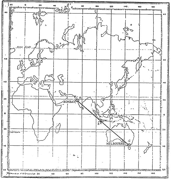
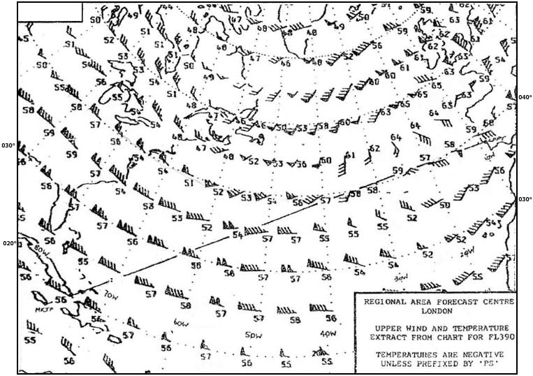
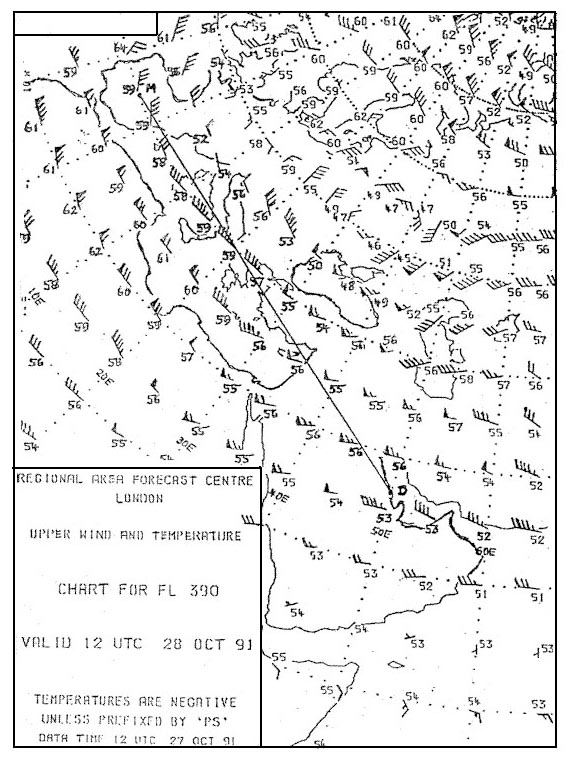
Question 157-29 : Considering that portion of the route indicated from 30°e to 50°e the upper winds in january above fl 300 are most likely to be 321 ?
A subtropical westerly jet stream maximum speed exceeding 90 kt.
589the subtropical jet stream is located around 30°n jet streams vary in height of 20000 ft to 40000 ft and can reach speeds of more than 240 kt 590A westerly polar front jet stream, maximum speed exceeding 90 kt. variable in direction and less than 30 kt. light easterlies.
Question 157-30 : The core of the polar front jet stream is usually located in the ?
Tropical air below the tropopause.
595Polar air above the tropopause. polar air below the tropopause. tropical air above the tropical tropopause.
Question 157-31 : A wind of 20 knots corresponds to an approximate speed of ?
10 ms.
1 kt equal around 05 ms50 km/h. 40 m/s. 10 km/h.
Question 157-32 : After a sunny day followed by a long clear night you take off from an airfield at mid latitudes an hour before sunrise the field is not situated close to the coastthough the pressure gradient is rather large the easterly surface wind is weak and makes ?
A sudden strong increase in wind speed and strong veering of the wind a short time after take off.
The long clear night will lead to surface temperature inversion radiation inversion between surface up to 500 ft the strong wind above this layer has a different direction since it is not affected by surface friction the inversion acts like a boundary between the two layersyou will have a sudden change in wind speed and directionLarge but gradual increase in wind speed and large but gradual veering of the wind up to a height of 5000 ft. little increase in wind speed and little veering of the wind up to an height of 5000 ft. a squally wind up to great heights.
Question 157-33 : At about what geographical latitude as average is assumed for the zone of prevailing westerlies ?
50°n.
596westerlies average latitude is 50°n and 50°s for south hemisphere 10°n. 30°n. 80°n.
Question 157-34 : At which time if any are polar front jet streams over the south pacific usually strongest ?
July.
Strongest polar front jet streams are in the winter and in south pacific southern hemisphere winter is in julyJanuary. there is no annual variation. october.
Question 157-35 : During periods of undisturbed radiation weather overland the ?
Surface wind speed tends to be highest during the mid afternoon.
With undistubed radiation weather the ground will get extremely hot reaching a maximum at about 1400 local time the heating will increase turbulence and that will 'pull' more freestream flow down into the boundary layer thus increasing the surface windless surface friction at night means none of the freestream gets 'pulled' down so you will have slower speed at nightSurface wind speed tends to be highest at night. angle between isobars and surface wind direction tends to be greatest in the mid afternoon. wind tends to back from early morning until early afternoon.
Question 157-36 : From summer to winter the polar front jet stream over the north atlantic moves ?
Towards the south and the speed increases.
Towards the north and the speed increases. towards the south and the speed decreases. towards the north and the speed decreases.
Question 157-37 : In relation to the polar front jet stream the greatest rate of wind shear is most likely to occur ?
Close to the core on the polar side.
The greatest rate of wind shear is most likely to occur close to the core on the polar side it is in the warm tropical air but on the cold air side of the coreWell below the core. on the tropical side of the core. 5000 ft or more above the core.
Question 157-38 : In summer in the northern hemisphere the maximum wind speeds associated with sub tropical jet streams are usually located ?
Below the tropopause at about 200 hpa.
The polar front sub tropical and equatorial jet streams are all just below the tropopause the sub tropical jetstream is at about fl390 in summer 200 hpa the highest wind speed is in the coreAbove the tropopause at about 100 hpa. below the tropopause at about 300 hpa. above the tropopause at about 250 hpa.
Question 157-39 : Isotachs are lines joining equal ?
Wind speeds.
Sea-level pressures. horizontal wind speed gradients. wind speed lapse rates.
Question 157-40 : Maximum wind speeds associated with subtropical jet streams are usually located in the ?
Tropical air below the tropopause.
The subtropical jet stream is located around 30°ns 590jet streams vary in height from 20000 ft close to the poles to 40000 ft at 30°ns and can reach speeds of more than 240 kt 534it is in the warm tropical air below the tropopause that the maximum wind speeds can be recordedTropical air above the tropopause. polar air above the tropopause. polar air below the tropopause.
Exclusive rights reserved. Reproduction prohibited under penalty of prosecution.