A free Premium account on the FCL.055 website! Read here
Sign up to unlock all our services and 15164 corrected and explained questions.
Question 158-1 : Sea breezes are most likely to occur when ? [ Learning aircraft ]
Slack pressure gradient and clear skies result in relatively high land temperatures
Question 158-2 : The length width and depth of a typical mid latitude jet stream are respectively ?
1000 mn 150 mn 10000 ft.
1000 mn, 150 mn, 30000 ft. 1000 mn, 5000 to 8000 ft, 30000ft. 200 mn, 5 mn, 10000 ft.
Question 158-3 : The most likely place to encounter clear air turbulence associated with a jet stream is ?
Close to the core on the side facing the polar air.
534the strongest cat is in the warm tropical air but on the cold polar air side of the coreWell below the core. on the tropical side of the core. 5000 feet or more above the core.
Question 158-4 : What surface wind is forecast for 2200 utc eddf 272200z 280624 vrb05kt 4000 br sct005 ovc013 becmg 1314 9000 shra ovc015 prob40 tempo 1416 vrb15g25kt 1600 tsra ovc010cb becmg 1618 26010kt bkn030 becmg 2122 cavok ?
260°10 kt.
Eddf 272200z forecast prepared on the twenty seventh day of the month at 22h00 utc 280624 vrb05kt 4000 br sct005 ovc013 becmg 1314 9000 shra ovc015 prob40 tempo 1416 vrb15g25kt 1600 tsra ovc010cb becmg 1618 26010kt the time period when the change is expectedthe gradual change will occur at an unspecified time within this time period the wind will change and remain unchanged until the end of the taf cavok does not change the wind bkn030 becmg 2122 cavokVariable/05 kt. variable/15 to 25 kt. calm.
Question 158-5 : What surface wind is forecast for eta 1700 utc at kingston mkjp 160430z 160606 36010kt 9999 few025cb becmg1315 14020g34kt few015cb sct025 prob30 tempo 1720 6000 +shra sct010 bkn015cb becmg 2301 34010kt few025= ?
140° 20 kt gusts 34 kt.
Becmg becoming indicates a change to forecast conditions is expected to occur slowly within the period designated in the time group immediately following the headingthe duration of this change is normally about 2 hours the elements included in the becmg line will supercede some of the previous taf groups but it is possible all the groups may changeany group omitted in the becmg line will be the same during the becmg period as indicated in the main taf linein this question the wind becoming 140°20 kt gusts 34 kt 14020g34kt between 13h and 15h it will remain unchanged until 23hthen the wind becoming 340°10kt between 23h and 01h360° / 10 kt. 340° / 10 kt. 140° / 27 kt.
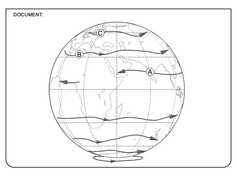
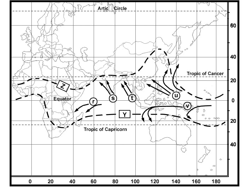
Question 158-6 : When and where is an easterly jet stream likely to be encountered ?
In summer from south east asia extending over southern india to central africa.
This jet occurs in the northern summer between 10°n and 20°n chiefly over or just to the south of high land masses such as in asia and africa its occurrence is due to a temperature gradient with colder air to the south which produces sufficient temperature differential above 45000 ft to give wind speeds of over 100 ktbecause colder temperatures at height are to the south it is an easterly jet this jet is now more usually known as the tropical easterly jet perhaps more correctly as it lies some distance from the equator 533In winter along the russian coast facing the arctic ocean. in summer from the middle east extending over the southern part of the mediterranean to southern spain. throughout the year to the south of the azorian high.
Question 158-7 : When compared to the geostrophic wind in the northern hemisphere surface friction will cause the surface wind to ?
Back and decrease.
At low elevations friction will slow the air and hence the coriolis force will be less effective in its deflection of the wind 561as the elevation decreases the direction backs changes direction in an counter clockwise motion in northern hemisphereat mid latitude over land wind speed in friction layer decrease by 50% angle between wind direction and isobars changes by 30° value to be used in examinations Back and increase. veer and decrease. veer and increase.
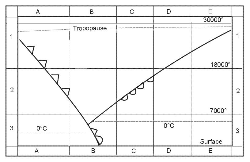
Question 158-8 : Which area of a polar front jet stream in the northern hemisphere has the highest probability of turbulence ?
Looking downstream the area to the left of the core.
534the jet is always below the tropopause and the strongest turbulence is in the warm tropical air but on the cold polar air side of the core looking downstream the area to the left of the core Looking downstream, the area to the right of the core. in the core of the jet stream. above the core in the boundary between warm and cold air.
Question 158-9 : Which of the following statements concerning the variation in wind speed between summer and winter on the north atlantic between fl 300 and fl 400 is most correct the average westerly component ?
Is greater in the winter.
The polar front jet on the north atlantic moves south and increases speed in the winter then moves north and decreases speed in the summerRemains the same all along the year. almost about zero in winter. is greater in the summer.
Question 158-10 : Which of the following types of jet streams can be observed all year round ?
Subtropical jet stream and polar front jet stream.
590polar front jet stream and subtropical jet stream can be observed all along the yearEquatorial jet stream and polar front jet stream. arctic jet stream and subtropical jet stream. equatorial jet stream and arctic jet stream.
Question 158-11 : Where as a general rule is the core of the polar front jet stream to be found ?
In the tropical air mass.
595 534the polar jet stream is always below the tropopause and in the warm tropical air massIn the polar air mass. just above the warm-air tropopause. just below the cold-air tropopause.
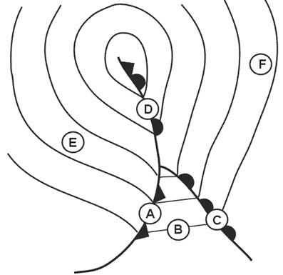
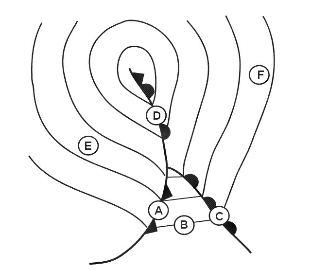
Question 158-12 : Where is the projection of the polar front jet stream on the surface most likely to be found in relation to the cold and warm fronts of a depression ?
50 to 200 nm behind the cold front and 300 to 450 nm ahead of the warm front.
A cold front has an inclined plane of 150 and a warm front an inclined plane of 1150 the projection of the polar front jet stream on the surface which is most likely to be found in relation to the cold and warm fronts of a depression will be located closer behind the cold front and far behind the warm frontUp to 100 nm either side of the cold front and up to 200 nm either side of the warm front. up to 200 nm either side of the cold front and up to 200 nm either side of the warm front. 300 to 450 nm behind the cold front and 50 to 200 nm ahead of the warm front.
Question 158-13 : Which statement is correct for the southern hemisphere ?
In the friction layer the wind backs with increasing height.
The jet streams are easterly. the wind veers at the passage of a cold front. if the wind veers with increasing height then warm air is advected.
Question 158-14 : What is the best approximation for the wind speed at flight level 250 ?
By interpolation of the wind information available from the 500 and 300 hpa charts while also considering the maximum wind information found on the significant weather chart.
By simple interpolation of wind information available from the 500 and 300 hpa charts. by reading wind direction and speed from the 300 hpa chart. by reading wind direction and speed from the 500 hpa chart.
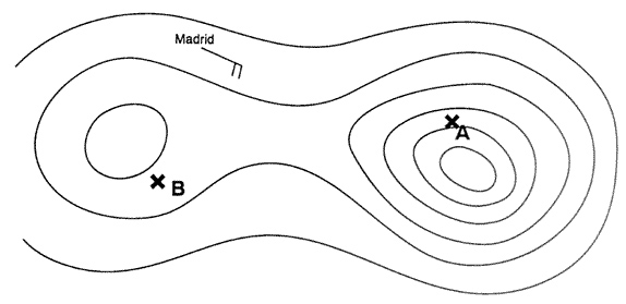
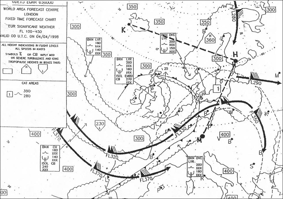
Question 158-15 : What is the average wind forecast for fl 300 between edinburgh and madrid 340 ?
280°30kt.
From edinburgh to madrid above england almost no windover the manche wind from 280° for 30 ktabove atlantique wind from 280° for 45 to 50 ktabove spain wind from 280° for 35 ktaverage forecast wind 280°30kt300°/45kt. 240°/25kt. 180°/20kt.
Question 158-16 : At 40°n 20°w the forecast wind at fl 390 is 345 ?
090°45 kt.
617pennants correspond to 50 ktfeathers correspond to 10 kthalf feathers correspond to 5 kt4 feathers + 1 half feather = 45 kt060°/45 kt. 070°/30 kt. 270°/45 kt.
Question 158-17 : What characteristics will the surface winds have in an area where the isobars on the weather map are very close together ?
Strong and flowing somewhat across the isobars.
When the isobars are close together the pressure gradient force is greater and wind velocities are strongerthe wind will be parallel to the isobars but surface friction will make the wind direction change to flow at an angle to the isobarsVery weak but gusty and flowing somewhat across the isobars. strong and flowing parallel to the isobars. moderate and flowing parallel to the isobars.
Question 158-18 : What is necessary for the development of a polar front jet stream ?
Strong horizontal temperature gradients.
The horizontal temperature gradient is essential for the formation of the thermal windStrong vertical temperature gradients. a uniform pressure pattern. an unstable atmosphere up to great heights.
Question 158-19 : The average forecast wind for the leg from madrid to dhahran at fl 390 is 361 ?
Question 158-20 : In the mid latitudes of the northern hemisphere the wind blows ?
Clockwise around anticyclones and anti clockwise around cyclones.
Clockwise around anticyclones and cyclones. clockwise around cyclones and anti-clockwise around anticyclones. direct from high to low pressure areas.
Question 158-21 : In the northern hemisphere with an anticyclonic pressure system the geostrophic wind at 2000 ft over the sea is 060°15ktat the same position the surface wind is most likely to be ?
050°10 kt.
values to be used in examinations over sea wind speed in friction layer decrease by 30% the wind in the friction layer blows across the isobars towards the low pressure angle between wind direction and isobars changes by 10°over land wind speed in friction layer decrease by 50% the wind in the friction layer blows across the isobars towards the low pressure angle between wind direction and isobars changes by 30°the wind blows parallel to the isobars and in the northern hemisphere the surface wind will back and slowdown compared to it060°/10 kt. 060°/20 kt. 070°/20 kt.
Question 158-22 : At which height and at what time of the year can an aircraft be affected by the equatorial jet stream ?
Fl 500 from june to august.
The equatorial jet is located between 5° and 15°n it is a seasonal zonal windit is generated by the high thermal gradients and barometrics between equator and asia and by the latent heat released above the indian sub continent humid monsoon begins in june it is located around an axis tibet senegal in summerthe tropopause is lower and warmer above the poles and higher and colder at the equator equatorial tropopause is around 14 to 16 km in summerthe equatorial jet is located just below the equatorial tropopauseFl 500 from november to february. fl 400 during the winter in the northern hemisphere. fl 400 during the winter in the southern hemisphere.
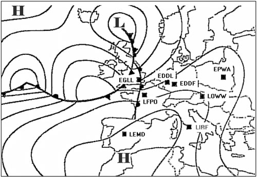
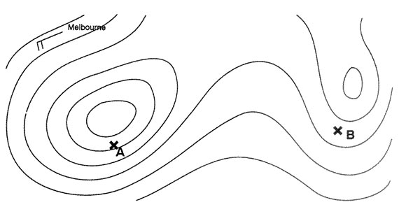
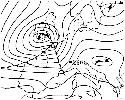
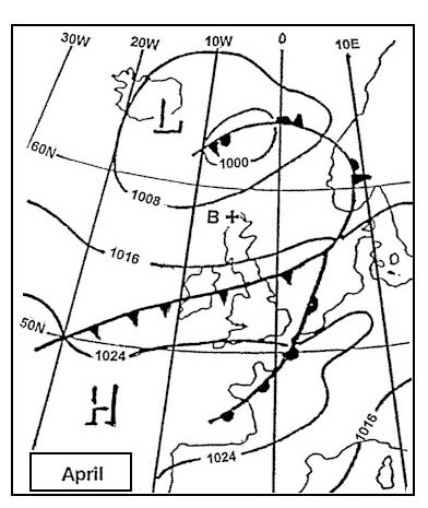
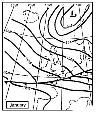
Question 158-23 : According to the extract of the surface isobar map the surface wind direction over the sea is approximately 365 ?
140°.
463in the northern hemisphere if you stand with your back to the wind low pressure is on your left buys ballot's law we are in southern hemispere situtation is reversed if you stand with your back to the wind low pressure is on your right so the wind blows parallel to the isobars from 130°over sea wind speed in friction layer decrease by 30% the wind in the friction layer blows across the isobars towards the low pressure angle between wind direction and isobars changes by 10° so answer is 140°310°. 220°. 110°.
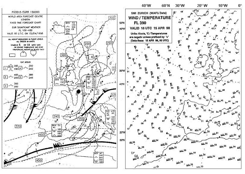
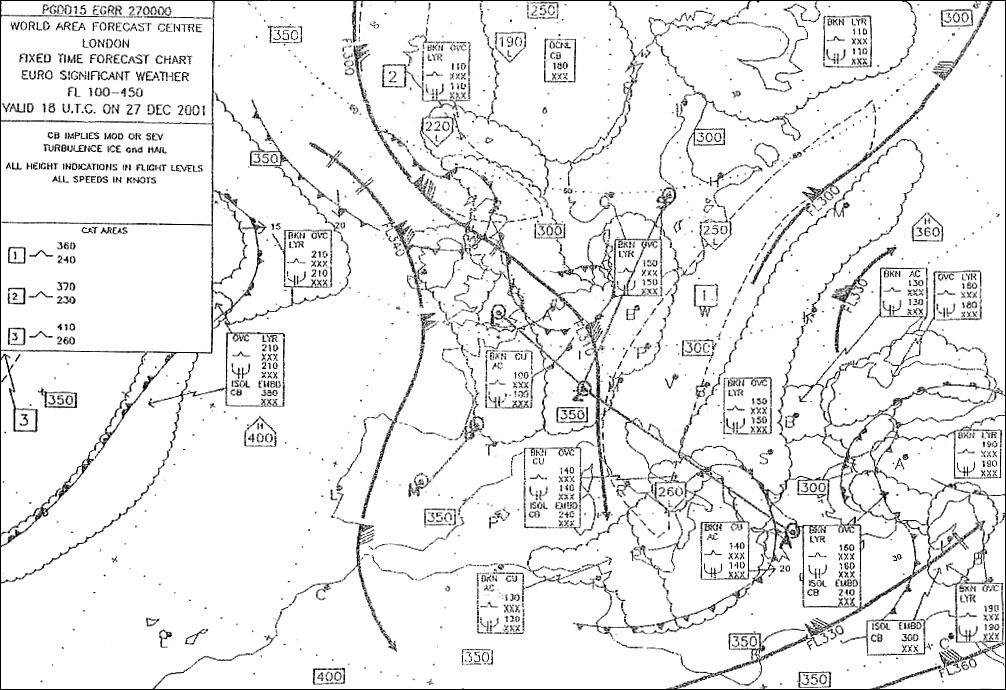
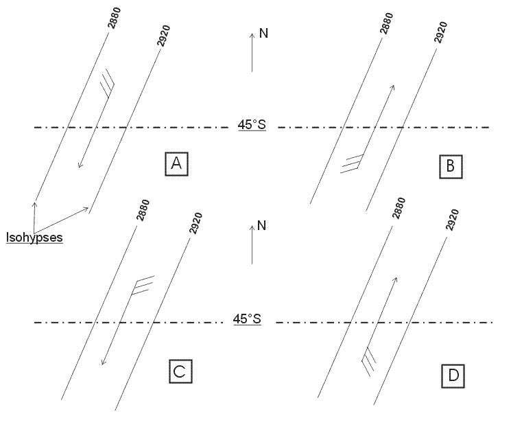
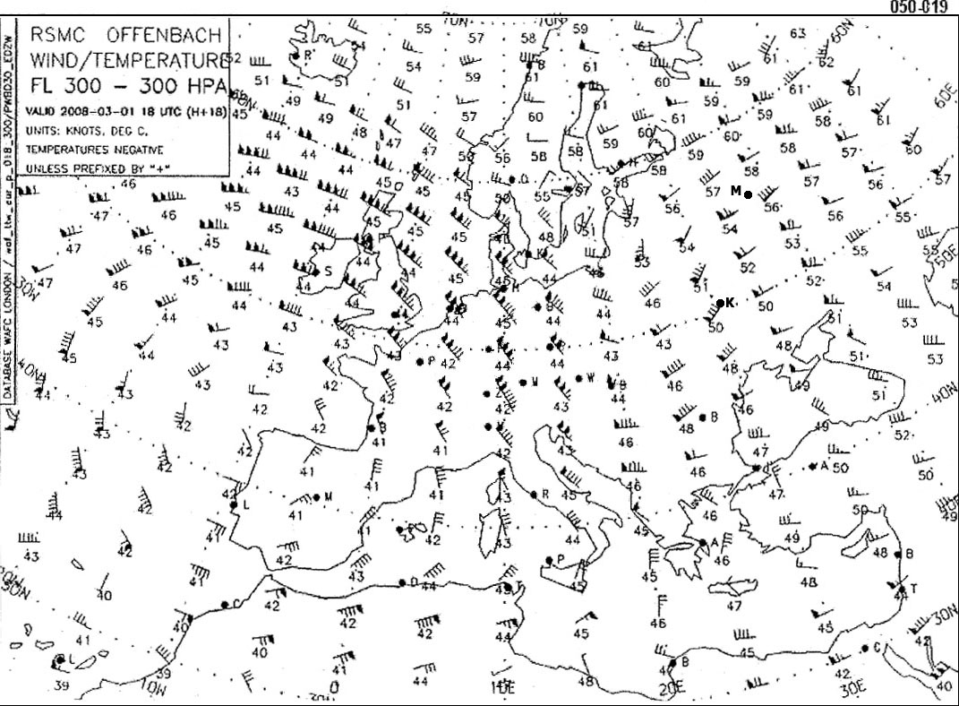
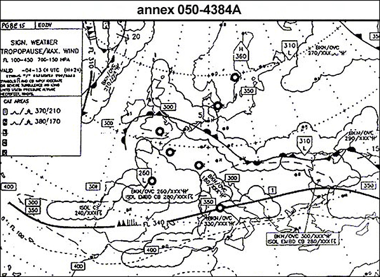
Question 158-24 : In appendix are shown four sections of the 700 hpa wind chart the diagram representing most accurately the wind direction and speed is 366 ?
030°30 kt diagram a .
If you stand with your back to the wind in the northern hemisphere low pressure is on your left buys ballot's law in the southern hemisphere if you stand with your back to the wind low pressure is on your right as in diagrams a and con upper wind charts the 'feathers' on the wind arrows are on the low pressurelow isohypse side of the arrow which is only correctly shown in diagram a210°/30 kt (diagram b). 030°/30 kt (diagram c). 210°/30 kt (diagram d).
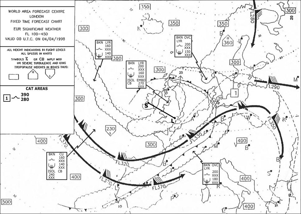
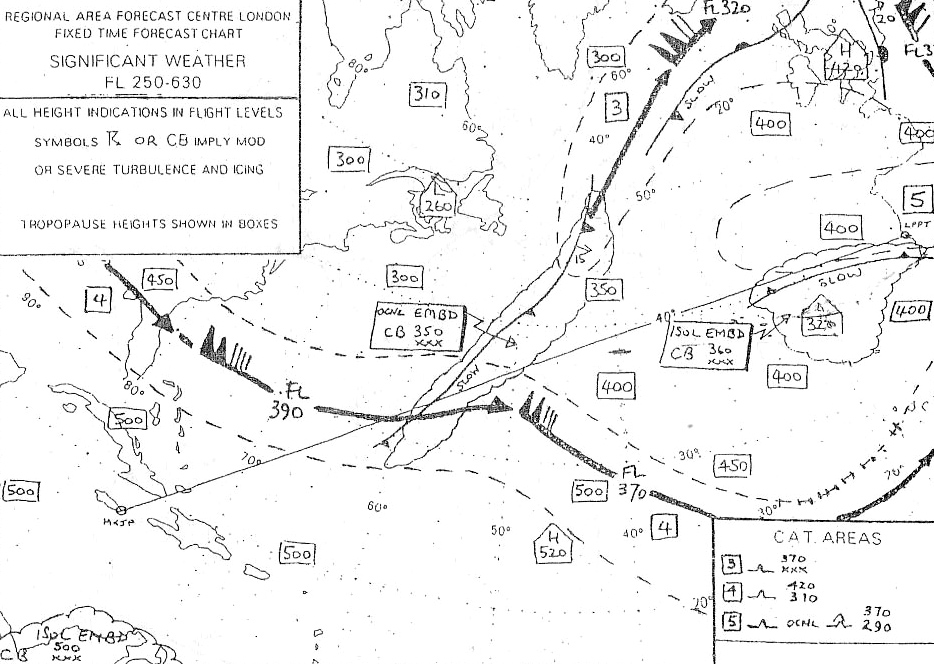
Question 158-25 : At fl 300 between geneva and tunis what mean wind would be most likely 367 ?
245°50 kt.
630wind direction is from 230+240+250+260 4 = 245°wind speed is 60+35+45+55 4 = 4875 kt225°/25 kt. 265°/40 kt. 265°/25 kt.
Question 158-26 : The mean wind that may be expected to affect the route segment from the coast of se england to geneva at fl 270 is 367 ?
22070kt.
Be careful we are looking at the wind only for the part from the coast of se england to geneva not from dublin to tunisover manche at fl240 wind is 200°55 ktbefore geneva at fl240 wind is 220°55 ktover manche at fl300 wind is 230°80 ktbefore geneva at fl300 wind is 240°80 ktwhitout calculation answer 22070 seems to be the mean wind at fl270245/55kt. 240/90kt. 270/70kt.
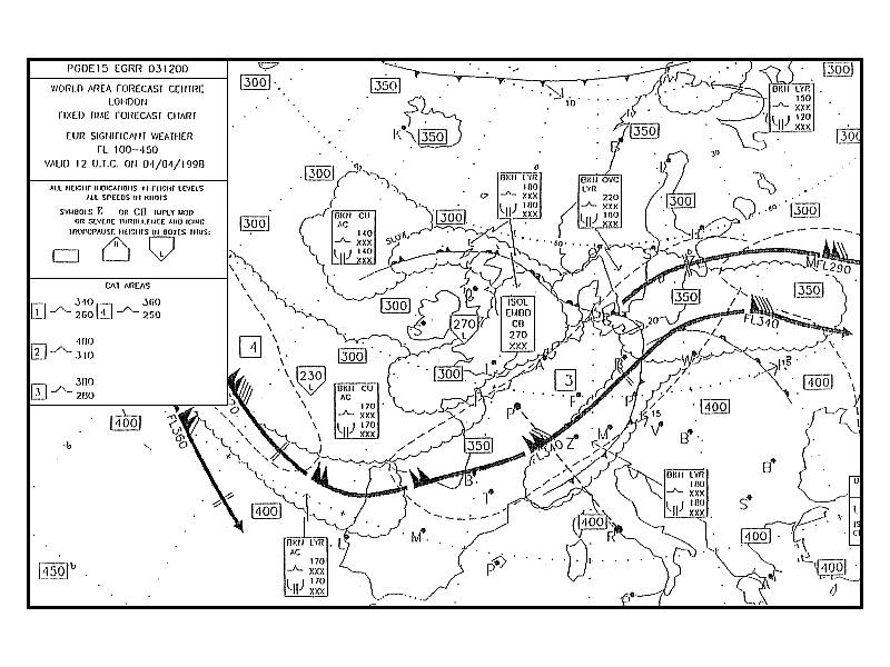
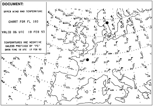
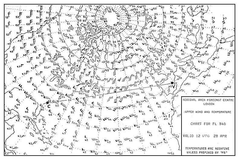
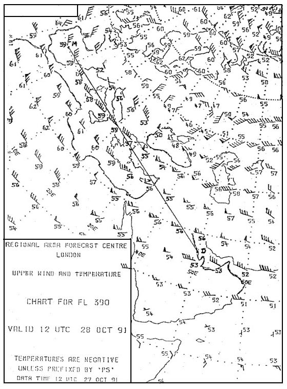
Question 158-27 : Judging by the chart what wind speeds can you expect at fl 310 above london 372 ?
90 kt.
632a jet stream is passing right above london at fl310pennants correspond to 50 ktfeathers correspond to 10 kthalf feathers correspond to 5 kt1 pennant + 4 feathers = 90 kt300 kt. 140 kt. 110 km/h.
Question 158-28 : When in the northern hemisphere at the same latitude the distance between isobars is equal then ?
The gradient wind in a low pressure area is weaker than in a high pressure area.
Pressure gradient is the difference in pressure between high and low pressure areas wind speed is directly proportional to the pressure gradient this means the strongest winds are in the areas where the pressure gradient is the greatest the stronger the pressure gradient the more tightly packed the isobars are the stronger the wind speed The geostrophic wind speed is less than the gradient wind speed in a low pressure area. the coriolis force in a high pressure area is smaller than the gradient force in a high pressure area. the wind around a low pressure area is stronger than around a high pressure area.
Question 158-29 : Which of the following statements is correct concerning the geostrophic wind ?
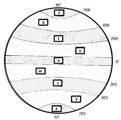
It is present at latitudes higher than about 15 degrees northsouth.
To have a geostrophic wind we need to have a pressure gradient force and coriolis force create by earth's rotation and depending on geographic latitude we need to have two differents air mass to have a pressure gradient force pgf 564since the earth rotates objects that are above the earth apparently move or are deflected if they are already moving owing to it's rotation this apparent motion is caused by the coriolis forcein the northern hemisphere objects will be deflected to their right while in the southern hemisphere objects will be deflected to their leftthe magnitude of the deflection is also a function of distance from the equator and velocity so the farther from the equator the object is the greater the deflection and the faster an object is moving the greater the deflectionthese 'objects' can be anything from airplanes to birds to missiles to parcels of air 565the effect of the coriolis force for various latitudes 566we can see that coriolis force is maximum at high latitudes and minimum at the equatorthus the geostrophic wind is present at latitudes higher than about 15° northsouthIt is present in a pressure system consisting of curved and non-parallel isobars. a horizontal temperature difference of at least 5 degrees celsius per 100 km is required to have geostrophic wind conditions. it is only present in the friction layer.
Question 158-30 : What is the significance to aviation of breaks or steps in the tropopause ?
They indicate the position of strong upper winds.
The 'breaks' or 'steps' in the tropopause are at the polar front and at the boundary between tropical and sub tropical air which is where the polar front and sub tropical jet streams are located 595this is the position of strong upper windsThey indicate the position and movement of anticyclones. they indicate the position and movement of tropical revolving storms. they indicate light winds at the surface (the 'horse latitudes').
Question 158-31 : Where are the westerlies to be expected ?
In the mid latitudes.
596westerlies average latitude are 50°n and 50°sIn the subtropical high pressure belt. between 10° and 30° north or south. between 65° and 80° north or south.
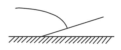
Question 158-32 : Katabatic wind is ?
A flow of cold air down the slope of a mountain.
Cqb15 september 2011A flow of cold air blowing from sea to land. a flow of warm air up the slope of a hill, caused by surface heating. a flow of warm air blowing from land to sea.
Question 158-33 : What is the average wind forecast for fl 300 between moscow and kiev 378 ?
26065.
636close to moscow wind is from 270°65 ktclose to kiev wind is from 250°80 kt230/55. 090/60. 050/60.
Question 158-34 : Which of the following is correct regarding geostrophic wind ?
It blows parallel to straight equidistant isobars.
The speed of a geostrophic wind calculated from the pressure gradient air density rotational velocity of the earth and latitude the calculation ignores the curvature of the wind's path a geostrophic wind is proportional to the pressure gradient or inversely proportional to the distance between the isobars 568winds exist because of horizontal and vertical pressure gradient so atmospheric motion can be deduced from isobaric surface charts etc if the horizontal pressure gradient force is exactly balanced in magnitude by coriolis effect accelerations of the air will be relatively small and a geostrophic wind will flow horizontally at a constant speed proportional to the isobaric spacing gradient perpendicular to the two opposing forces and parallel to straight isobars thus geostrophic wind speed is proportional to the pressure gradient the closer the isobars the higher will be geostrophic wind speedIt blows parallel to curved isobars. it blows across the isobars from high to low pressure. it is the wind resulting from the vector sum of gradient wind and surface wind, such that the geostrophic wind normally blows at an angle of 20-45 degrees relative to the isobars.
Question 158-35 : In this question the wind speed with straight isobars vst the wind speed around a high pressure system vhigh and the wind speed around a low pressure system vlow in the southern hemisphere are being compared while pressure gradient and latitude constantwhich statement is correct ?
Vst < vhigh and vst > vlow.
For same pressure gradient and same latitude the gradient wind is 'high round a high' vhigh and 'low round a low' vlow when compared to the geostrophic wind vst Vst > vhigh and vst < vlow. vst < vhigh and vst < vlow. vst > vhigh and vst > vlow.
Question 158-36 : Which of the following is correct regarding the wind speed in a jet stream in the northern hemisphere ?
With colder air to the left when looking downwind the wind speed increases with height while with the colder air to the right the wind speed decreases with height.
The jet lies in the warm air above the frontal surface looking downwind the warm air tropopause lies to the right and above the core the cold air tropopause to the left and a litle lower than the core 637looking downwind the air in a jet core slowly rotates in a counterclockwise fashionif you stand with your back to the wind and have cold air on your left you are below the core of the jet and wind speed will increase as you climb if you stand with your back to the wind and colder air the colder air from the warm tropopause which is colder than the air of the cold tropopause is on your right you are above the core of the jet and wind speed will decrease as you climbWith colder air behind when looking downwind, the windspeed increases with height, while with the colder air ahead the windspeed decreases with height. with colder air to the left when looking upwind, the wind speed increases with height, while with the colder air to the right the wind speed decreases with height. with colder air ahead when looking downwind, the wind speed increases with height, while with the colder air behind the wind speed decreases with height.
Question 158-37 : Strongest clear air turbulence is to be expected ?
On the cold air side of the jet stream core.
This question is similar to question 266 in which zone of a polar front jet stream is the strongest cat to be expected on the polar air side of the core 534the strongest cat is in the warm tropical air but on the cold polar air side of the coreOn the warm air side of the jet stream core. in the jet stream core. about 10000 ft above the jet stream core.
Question 158-38 : Which of the following statements is correct regarding the variation of wind with height ?
The wind normally veers during climb out through the first 2000 3000 feet in the northern hemisphere.
The wind normally backs during climb out through the first 2000-3000 feet in the northern hemisphere. the wind strength normally increases by a factor of 2 per 1000 feet up to the 850 hpa level. the wind strength normally increases by a factor of 2 per 500 feet up to the 700 hpa level.
Question 158-39 : On which latitudes can the coriolis force in practice be neglected for meteorological purposes ?
From 0 to about 10 degrees north and south.
From about 10 to about 30 degrees north and south. from about 30 to about 75 degrees north and south. from about 75 to 90 degrees north and south.
Question 158-40 : Where is the wind speed of a polar front jet stream normally at its strongest ?
In the area between a trough and a ridge.
Generally a trough of low pressure refers to region of low pressure within v shaped isobars it usually projects from a large and distant depression there is a sudden wind shift across the axis the axis is shown as broken lines on a weather chart of the trough which is associated with cloud and raina ridge of high pressure refers to a wedge shaped extension of a high pressure area and occurs between two depressions or lows wind shift is gradual across a ridge shown as zig zag line the ridge has a central area of light winds and clear skiesthe ridge and trough are usually associated with different air masses warm and coldthis is where you get maximum temperature contrast and strongest thermal wind speedIn the area of a trough. in the area where the jet stream is curving around a depression. in the area where the jet stream is curving around an anticyclone.
Exclusive rights reserved. Reproduction prohibited under penalty of prosecution.