A free Premium account on the FCL.055 website! Read here
Sign up to unlock all our services and 15164 corrected and explained questions.
Question 161-1 : Relative humidity at a given temperature is the relation between ? [ Formation assignment ]
Actual water vapour content and saturated water vapour content
Question 161-2 : A parcel of unsaturated air is forced to rise through an isothermal layer so long as it remains unsaturated the temperature of the parcel ?
Decreases 1°c per 100 m.
unsaturated air and forced to rise ascending mean dry adiabatic lapse rate and we know that the environmental lapse rate elr is more than 3°c1000ft for dry adiabatic lapse rate 1°c par 100 m Remains constant. decreases 0.65°c per 100 m. becomes equal to the temperature of the isothermal layer.
Question 161-3 : Absolute instability in the atmosphere will occur when the environmental lapse rate is ?
Greater than both saturated adiabatic lapse rate and dry adiabatic lapse rate.
If the environmental lapse rate elr is more than 3°c1000 ft dry adiabatic lapse rate the environment is unstableif the environmental lapse rate elr is less than 18°c1000 ft saturated adiabatic lapse rate the environment is stablebut if the environmental lapse rate elr is more than 18°c1000 ft but less than 3°c1000 ft we have conditional stability stable if air is dry unsaturated or unstable if air is saturated Less than saturated adiabatic lapse rate less than both saturated adiabatic lapse rate and dry adiabatic lapse rate greater than saturated adiabatic lapse rate but less than dry adiabatic lapse rate
Question 161-4 : For both saturated and unsaturated air instability will occur when the ?
Environmental lapse rate is greater than both dry adiabatic lapse rate and saturated adiabatic lapse rate.
If the environmental lapse rate elr is more than 3°c1000 ft dry adiabatic lapse rate the environment is unstableif the environmental lapse rate elr is less than 18°c1000 ft saturated adiabatic lapse rate the environment is stablebut if the environmental lapse rate elr is more than 18°c1000 ft but less than 3°c1000 ft we have conditional stability stable if air is dry unsaturated or unstable if air is saturated Environmental lapse rate is greater than saturated adiabatic lapse rate but less than dry adiabatic lapse rate environmental lapse rate is less than both dry adiabatic lapse rate and saturated adiabatic lapse rate dry adiabatic lapse rate is less than saturated adiabatic lapse rate but greater than environmental lapse rate
Question 161-5 : In the lower levels of the atmosphere when the environmental lapse rate is greater than saturated adiabatic lapse rate but less than dry adiabatic lapse rate the air mass is described as being ?
Conditionally unstable.
If the environmental lapse rate elr is more than 3°c1000 ft dry adiabatic lapse rate the environment is unstableif the environmental lapse rate elr is less than 18°c1000 ft saturated adiabatic lapse rate the environment is stablebut if the environmental lapse rate elr is more than 18°c1000 ft but less than 3°c1000 ft we have conditional stability stable if air is dry unsaturated or unstable if air is saturated Stable. unstable. absolutely unstable.
Question 161-6 : Surface temperature inversions are frequently generated by ?
Terrestrial radiation on a calm clear night.
The cooling of land after sunset by thermal radiation in calm conditions with clear sky will generate ground inversionsAn unstable air mass causing convection currents and mixing of the atmosphere at lower levels. gusting winds increasing surface friction during the day with consequent mixing at the lower levels. compression causing the release of latent heat in a layer of stratiform cloud.
Question 161-7 : Surface based temperature inversions are common during ?
Cloud free nights in winter when the ground is dry.
A temperature inversion is a thin layer of the atmosphere where the normal decrease in temperature with height switches to the temperature increasing with height a long clear winter night will lead to surface temperature inversion radiation inversion between surface up to 500 ft Cloud-free days in summer when the ground is dry. cloudy days in summer when the ground is wet. cloudy days in winter when the ground is wet.
Question 161-8 : The maximum vapour pressure over a flat supercooled water surface and the maximum vapour pressure over a flat ice surface of the same temperature are comparedthe maximum vapour pressure is ?
Greater over the water surface.
The maximum vapour pressure is greater over the water surface because it is easier for the flat supercooled liquid water to change state into vapour the flat ice surface has to sublimate into vapour there will be more molecules of water vapour in the atmosphere over the supercooled water than over the ice pressure will be greater Smaller over the water surface. equal over both surfaces. the same over both surfaces if the air pressure is the same.
Question 161-9 : The stability in a layer increases by advection of ?
Cold air in the lower part.
The stability of the atmosphere depends on its ability to resist vertical motionthere are 2 things to have a look at moisture advection and temperature advectiona moisture advection since water vapour is lighter than air moisture decreases air density causing it to rise since moist air cools at a slower rate it is generally less stable than dry air since the moist air must rise higher before its temperature cools to that of the surrounding air the dry adiabatic lapse rate unsaturated air is 3°c per 1000 feet the moist adiabatic lapse rate varies from 18°c to 3°c per 1000 feetit's not answer moist air in the lower part dry air is heavier and will want to sink therefore dry air aloft decreases stability as less dry air below will tend to rise and replace itit's not answer dry air in the upper part b temperature advection advecting warm air in the lower parts of the troposphere will make the parcel warmer than its surrounding therefore it'll keep risingit's not answer warm air in the lower part conclusion the combination of moisture and temperature determine the stability of the air cool dry air is very stable and resists vertical movement the greatest instability occurs when the air is moist and warm as it is in the tropical regions in the summercorrect answer is cold air in the lower part Warm air in the lower part. dry air in the upper part. moist air in the lower part.
Question 161-10 : The temperature at the surface is given as +15°c and at 4000 ft it is +9°c the state of this layer is said to be ?
Stable.
Between surface and 4000 ft the temperature drops by 6°c or 15°c per 1000 ft if the environmental lapse rate elr is more than 3°c1000 ft dry adiabatic lapse rate the environment is unstableif the environmental lapse rate elr is less than 18°c1000 ft saturated adiabatic lapse rate the environment is stable if the environmental lapse rate elr is more than 18°c1000 ft but less than 3°c1000 ft we have conditional stability stable if air is dryor unstable if air is saturatedConditionally unstable. absolutely unstable. unstable.
Question 161-11 : Which of the following phenomena is least likely to lead to the formation of a cumulonimbus with thunderstorm ?
Ground radiation.
Convection convergence and orographic lift can all lead to the formation of a cumulonimbus with thunderstorm ground radiation will dissipate clouds or generate a convective activity and may sometimes create cumulus cloudsConvection. convergence. orographic lift.
Question 161-12 : Which of the following sets of conditions are most favourable to the development of thunderstorms ?
Environmental lapse rate greater than saturated adiabatic lapse rate through a great vertical extent high relative humidity and an initial lifting process.
Extensive isothermal layer, ice particles and water droplets must exist just below the freezing level and orographic lifting environmental lapse rate less than saturated adiabatic lapse rate with dew point below 0°c and considerable surface heating environmental lapse rate less than dry adiabatic lapse rate with freezing level below the cloud base, high relative humidity and strong surface winds
Question 161-13 : Which of the following statements is correct ?
The bergeron findeisen process is mainly based on the difference of maximum vapour pressure over water and over ice of the same temperature.
The saturation vapour pressure is higher over water than over ice what that means that you will reach the frost point before you reach the dew point bergeron showed that in the mid latiudes because it is cold inside clouds precipitation is caused mainly by the coalence of water vapour onto ice crystals it does not explain everything and is just one of the theories of precipitation if there are no nuclei present you can raise the relative humidity to 460% before a drop will form spontaneously super saturation The principle of the bergeron-findeisen process is mainly based on the difference in size of the cloud elements. at mid-latitudes the coalescense process is usually the initial process in the formation of precipitation. in the tropics stratiform precipitation does not occur.
Question 161-14 : Which of the following statements is true of the dew point of an air mass ?
It can only be equal to or lower than the temperature of the air mass.
The dewpoint temperature is the temperature at which the air can no longer hold all of its water vapor and some of the water vapor must condense into liquid water the dew point is always lower than or equal to the air temperatureif the air temperature cools to the dew point or if the dew point rises to equal the air temperature then dew fog or clouds begin to format this point where the dew point temperature equals the air temperature the relative humidity is 100%It can be higher than the temperature of the air mass. it can be used together with the air pressure to estimate the air mass's relative humidity. it can be used to estimate the air mass's relative humidity even if the air temperature is unknown.
Question 161-15 : Which one of the following can provide the initial lifting leading to air mass thunderstorms ?
Advection of cold air over a warm sea.
Cold air over a warm surface gives convective liftingMountain waves. advection of warm air over a cold sea. low level wind shear.
Question 161-16 : Which of the following quantities remains unchanged if unsaturated air is lifted until it reaches the lifting condensation level ?
Mixing ratio.
If unsaturated air dry adiabatic lapse rate is lifted until it reaches the lifting condensation level the ratio of water vapour to air by mass called 'mass ratio' or 'mixing ratio' will remained unchangedthe mixing ratio of water vapor in air is used to describe humidityDifference between temperature and dewpoint temperature. maximum vapour pressure. maximum mixing ratio.
Question 161-17 : Which of the following processes will increase the stability of an air mass ?
Cooling by the underlying surface.
Addition of water vapour in the lower layer. warming of the air mass from below. advection of colder air aloft.
Question 161-18 : Which statement is correct for an absolutely unstable atmosphere ?
Visibility is good between showers.
If the environmental lapse rate elr is more than 3°c1000 ft dry adiabatic lapse rate the environment is unstablestable air will produce stratiform cloudunstable air mass produces showers under cumulonimbus clouds outside showers visibilty is goodThe environmental lapse rate is less than 1°c / 100 m. clouds are mainly of the stratiform type. the dry adiabatic lapse rate is more than 1°c / 100 m.
Question 161-19 : Relative humidity ?
Increases if the air is cooled whilst maintaining the vapour pressure constant.
The air contracts therefore takes less volumethe water quantity does not change maintaining the vapour pressure constant' thus relative humidity increasesIs higher in warm air than in cool air. is higher in cool air than in warm air. decreases if the air is cooled whilst maintaining the vapour pressure constant.
Question 161-20 : What is true for the water vapour distribution in the layer between the surface and the 500 hpa pressure surface in the tradewind belt ?
The lower part is relatively moist and the upper part is relatively dry.
500 hpa = fl 180se trade winds and ne trade winds converge at the itcz intertropical convergence zone they occur only in the lower part of the troposphere and are more pronounced over the oceans in the trade winds there is a maximum of humidity as a result of the trade winds long sea passagein the upper part the air originates from the sub tropical high pressure belt is sinking warming adiabatically if temperature increases relative humidity will decrease the upper part is relatively dryThe whole layer is relatively dry. the whole layer is relatively moist. the lower part is relatively dry and the upper part is relatively moist.
Question 161-21 : What is the dry adiabatic lapse rate ?
30°c1000 ft.
The dry adiabatic lapse rate has a constant fixed value of 1°c100 m 3°c1000 ft 2.0°c/1000 ft 1.5°c/1000 ft 3.5°c/1000 ft
Question 161-22 : What is a characteristic of stable air ?
Stratiform clouds.
Unlimited visibility. fair weather cumulus clouds. temperature decreases rapidly.
Question 161-23 : What is a characteristic phenomenon for a stable atmosphere ?
Stratified clouds.
The words to distinguish between clouds produced by instability and other clouds are stratiformstratified for clouds forming in a stable layer and convective clouds for clouds developing in an unstable environment stratiform clouds are basically flat and layered stable clouds include cirrostratus altostratus nimbostratus and stratusconvective clouds have vertical development and often extend through a significant depth of the troposphereconvective clouds include cumulonimbus cumulus cirrus and altocumulusWeak wind. no precipitation. many vertical currents.
Question 161-24 : In an unsaturated layer in the friction layer the air is well mixed by turbulence the layer remains unsaturated after some time the vertical temperature profile will ?
Correspond to the dry adiabatic lapse rate.
If the layer remains unsatured we have a conditional stability depending on dry or satured air but mixing the temperature in the turbulence layer will change the vertical temperature profile by increasing the vertical rate of temperature change it will correspond to the dry adiabatic lapse rateAt first coincide with the average dry adiabat and then coincide with the average wet adiabat. always change toward a more stable position. coincide with the average wet adiabat in the layer.
Question 161-25 : Good visibility in the lower levels may be expected when ?
Cool dry air is moving over a warmer surface.
Good visibility is associated with unstable air a cool dry air moving over a warm surface will become unstableWarm air is moving over a cold surface. the atmospheric pressure is low. the air temperature is low.
Question 161-26 : A layer of stratus is most likely to be dispersed by ?
Insolation resulting in the lifting of the condensation level.
Absorption of longwaved solar radiation in the stratus layer. the release of latent heat due to precipitation. adiabatic cooling due to subsidence.
Question 161-27 : After a clear night cumuliform clouds are formed in the morning why can the base of these clouds become higher during the day ?
Because the surface temperature increases.
The wind speed is increasing, because the cold air mass changes into a warm air mass. because the stability increases. because the difference between the temperature and the dewpoint temperature at the initial condensation level becomes smaller.
Question 161-28 : Air masses which are being cooled from below are often characterized by ?
Fog poor visibility and layered clouds.
Strong winds, cumulus clouds, good visibility. uniform temperature, good visibility. continuous rain and freezing temperatures.
Question 161-29 : An inversion is ?
An absolutely stable layer.
A conditionally unstable layer an unstable layer a layer that can be either stable or unstable
Question 161-30 : An unstable air mass is forced to ascend a mountain slope what type of clouds can be expected ?
Clouds with considerable vertical development and associated turbulence.
Unstable air = cumulusstable air = stratusthis question has been seen at the exam with this wording a conditionally unstable air mass is forced to ascend a mountain slope what type of clouds can be expected right answer remains unchangedStratiform clouds with considerable turbulence. layer-like clouds with little vertical development. stratiform clouds with a temperature inversion.
Question 161-31 : 88 stratus base 200 ftagl is observed at sunrise at an aerodrome in the north of francethe qnh is 1028 hpa and there is a variable wind of 3 ktwhat change in these clouds is likely at 1200 utc in summer and winter ?
Winter ovc base 500 ftagl summer sct base 3000 ftagl.
Winter limited heating during the day will raise the cloud base slightlysummer more heating will raise the cloud base and dissipate some of the cloudthe relatively high pressure 1028 hpa and light winds indicate anticyclonic conditions with stable airWinter: clear sky, summer: bkn cb, base 1500 ft/agl. winter: bkn, base 2500 ft/agl, summer: bkn, base 3500 ft/agl. winter: sct, base 3000 ft/agl, summer: ovc, base 500 ft/agl.
Question 161-32 : The dewpoint temperature ?
Can be reached by cooling the air whilst keeping pressure constant.
Can be reached by lowering the pressure whilst keeping temperature constant can not be equal to the air temperature can not be lower than the air temperature
Question 161-33 : The amount of water vapour which air can hold largely depends on ?
Air temperature.
The most commonly used measure of humidity is relative humidity relative humidity can be simply defined as the amount of water in the air relative to the saturation amount the air can hold at a given temperature multiplied by 100 air with a relative humidity of 50% contains a half of the water vapor it could hold at a particular temperature 501 concept of relative humidity we can say that the amount of water vapour which air can hold largely depends on air temperature Stability of air. relative humidity. the dew point.
Question 161-34 : A given mass of air is saturated with water vapour no condensed water if temperature increases ?
The amount of water vapour remains constant.
Revised ecqb03 july 2016The amount of water vapour decreases relative humidity increases. relative humidity remains constant.
Question 161-35 : Which of the following changes of state is known as freezing ?
Liquid to solid.
Cqb15 july 2011Gas to solid. liquid to gas. solid to liquid.
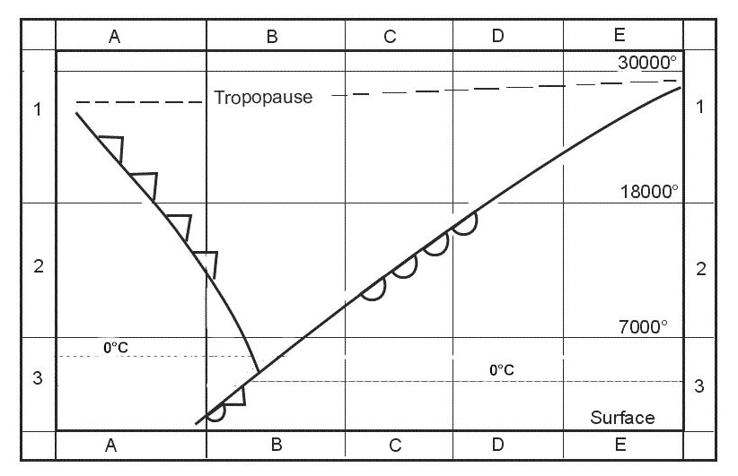
Question 161-36 : Consider a parcel of air which is moved upwards in the surrounding air by an external forcewhich one of the following situations describes instability the parcel ?
Tends to gain altitude after being released.
Take parcels of air that are initially in equilibrium with their environment by equilibrium we mean that the temperature density of the air inside a stationary parcel is the same as its environment now give a parcel of air a push upward for a parcel in contact with the ground an upward push is the only choice possible but air parcels aloft may be given a push upward or downward to test their stability if after a push upwards the test parcel returns to its original position the layer of the atmosphere where the test took place is said to be stablethe atmosphere is unstable when if a parcel starting at equilibrium is displaced slightly upward relative to its surrounding environment it finds itself warmer than its environment at its new altitude and therefore continues to rise spontaneously away from its starting pointTends to maintain its new altitude after being released. tends to return to its original altitude when it is released. tends to descend when it is released. it will move to, and maintain an altitude below its original altitude.
Question 161-37 : In which of the following changes of state is latent heat absorbed ?
Liquid to gas.
Easa 2014latent heat is absorbed when going from liquid to gas solid to liquid solid to gaslatent heat is released when going from gas to liquid liquid to solid gas to solidLiquid to solid. gas to solid. gas to liquid.
Question 161-38 : In which of the following changes of state is latent heat released ?
Gas to solid.
Easa 2014latent heat is absorbed when going from liquid to gas solid to liquid solid to gaslatent heat is released when going from gas to liquid liquid to solid gas to solidSolid to liquid. solid to gas. liquid to gas.
Question 161-39 : What is foehn wind ?
It is an adiabatically heated wind blowing down a mountain side the temperature on the lee side is normally higher than on the windward side of the mountain at the same level.
It is a flow of warm air up a slope of a hill caused by surface heating. it is a warm and moist anabatic wind that usually carries precipitation. it is an adiabatically heated wind blowing down a mountain side. the temperature on the lee side is normally lower than on the windward side of the mountain at the same level.
Question 161-40 : What is 'mixing ratio' ?
The number of grammes of water vapour per kilogramme of dry air.
The percentage of water drops per volume unit of dry air. the volume of water vapour which is mixed with each volume unit of dry air. the ratio between actual water vapour content and saturated water vapour content.
Exclusive rights reserved. Reproduction prohibited under penalty of prosecution.