A free Premium account on the FCL.055 website! Read here
Sign up to unlock all our services and 15164 corrected and explained questions.
Question 162-1 : A night in january has been cold and clear in the forenoon of the next day an airfield is in imc due to fog which extends to a height of 700 ft a heavily laden aircraft departs and when breaking through the top of the fog experiences temporary bumpiness and a sudden decrease in climb ratemark the ? [ Formation assignment ]
The aircraft suffers reduced lift and thrust due to a temperature inversion at the top of the fog
Question 162-2 : Which of the following changes of state is known as melting ?
Solid to liquid.
Solid to gas. liquid to solid. liquid to gas.
Question 162-3 : In which of the following changes of state is latent heat absorbed ?
Solid to liquid.
Easa 2014latent heat is absorbed when going from liquid to gas solid to liquid solid to gaslatent heat is released when going from gas to liquid liquid to solid gas to solidLiquid to solid. gas to solid. gas to liquid.
Question 162-4 : Which of the following changes of state is known as evaporation ?
Liquid to gas.
Ecqb01 2013Liquid to solid. gas to solid. solid to liquid.
Question 162-5 : Which of the following changes of state is known as condensation ?
Gas to liquid.
Ecqb01 2013Gas to solid. liquid to gas. liquid to solid.
Question 162-6 : Check the correctness of the following statements 1 the maximum water vapor pressure is higher over ice than over water with the same temperature2 for unsaturated air the dew point temperature is lower than the outside temperature ?
1 is incorrect and 2 is correct.
When the dew point is lower than oat the air is unsaturatedwhen the dew point is equal to oat the air is saturated1 and 2 are incorrect. 1 is correct and 2 is incorrect. 1 and 2 are correct.
Question 162-7 : In an isothermal layer the state of the atmosphere is ?
Absolutely stable.
Easa 2014an isothermal layer is a layer of air in which the temperature remains constant with heightfor example the layer just above the tropopause is absolutely stable from 12 km to 25 km the temperature does not vary with height it is an isothermal layer where we have absolute stability Absolutely unstable. neutral. conditionally unstable.
Question 162-8 : In which of the following changes of state is latent heat absorbed ?
Solid to gas.
Easa 2014latent heat is absorbed when going from liquid to gas solid to liquid solid to gaslatent heat is released when going from gas to liquid liquid to solid gas to solidLiquid to solid. gas to solid. gas to liquid.
Question 162-9 : Given the following information what is the approximate relative humidity of the air mass temperature 15° cdew point 10° c ?
75%.
Usually we need to know the 'water pressure of water'since this data is not given we can use this basic formula relative humidity = dew point temperature x 100relative humidity = 10 15 x 100 = 67%closest answer is 75%50%. 55%. 95%.
Question 162-10 : As regards water which state change process delivers the main part of the energy in thunderstorms and hurricanes ?
Condensation.
Ecqb03 july 2016Freezing. evaporation. sublimation.
Question 162-11 : Several physical processes contribute to atmospheric warming which of the following contribute the most ?
Convection and condensation.
Solar radiation and conduction. absorption and vaporisation. absorption and evaporation.
Question 162-12 : What is the mean temperature deviation from isa for the frankfurt roma route 403 ?
4°c colder than isa.
4°c warmer than isa. 10°c colder than isa. 10°c warmer than isa.
Question 162-13 : During a high altitude flight favourable contrail formation conditions are ?
High humidity low temperatures and presence of aerosols.
High humidity, low temperatures and absence of aerosols. low humidity, high temperatures and presence of aerosols. high humidity, high temperatures and presence of aerosols.
Question 162-14 : An inversion is a layer of air in which the temperature ?
Increases with increasing altitude.
Decreases by more than 1°c per 100 m with altitude. decreases by less than 1°c per 100 m with altitude. remains unchanged with increasing altitude.
Question 162-15 : In which of these cloud types can icing be virtually ruled out ?
Cirrus ci .
Cirrus clouds are very high clouds and they are composed of ice crystalscirrus clouds do not result in structural icing the reason for that is the moisture is already frozen in the form of ice crystals and it doesn't deposit on the airframe as do super cooled water droplets which might exist in stratus or cumulus clouds 642Stratocumulus (sc). nimbostratus (ns). cumulus (cu).
Question 162-16 : The most likely reason for radiation fog to dissipate or become low stratus is ?
Increasing surface wind speed.
An increasingly stable atmosphere. surface cooling. a low level temperature inversion.
Question 162-17 : What conditions are most likely to lead to the formation of hill fog ?
Humid stable air mass wind blowing towards the hills.
High relative humidity, wind blowing parallel in range and an unstable air mass. clear skies, calm or light winds, with relatively low humidity. precipitation which is lifted by the action of moderate winds striking the range.
Question 162-18 : Clouds fog or dew will always be formed when ?
Water vapour condenses.
A cloud is a large collection of very tiny droplets of water or ice crystals fog and dew are a collection of very tiny droplets of watercondensation is the process by which water vapor in the air is changed into liquid waterWater vapour is present. relative humidity reaches 98%. temperature and dew point are nearly equal.
Question 162-19 : Which of the following is a cause of stratus forming over flat land ?
Radiation during the night from the earth surface in moderate wind.
Unstable air. convection during the day. the release of latent heat.
Question 162-20 : Which of the following processes within a layer of air may lead to the building of cu and cb clouds ?
Convection.
Radiation. subsidence. frontal lifting within stable layers.
Question 162-21 : What are the characteristics of cumuliform clouds ?
Large water droplets instability turbulence showers and mainly clear ice.
Small water droplets, stability, no turbulence and extensive areas of rain. large water droplets, stability, no turbulence, showers and mainly rime ice. small water droplets, instability, turbulence, extensive areas of rain and rime ice.
Question 162-22 : Which of the following clouds are classified as medium level clouds in temperate regions ?
As ac.
503Sc, ns ci, cc. cs, st.
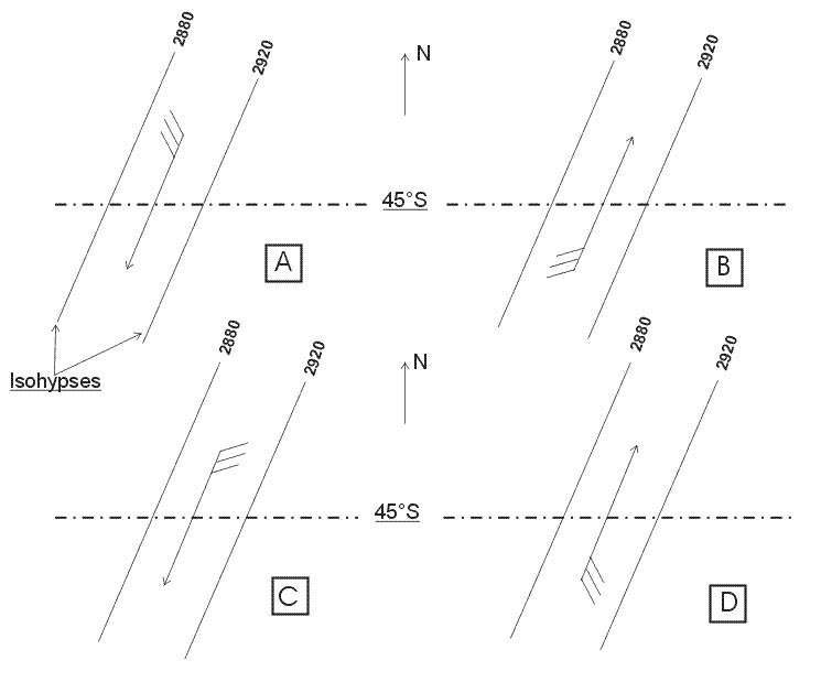
Question 162-23 : Which one of the displayed cloud forms is representative of altocumulus castellanus 253 ?
N°3.
N°1. n°2. n°4.
Question 162-24 : What is the main composition of clouds classified as 'high level clouds' ?
Ice crystals.
Cirrus cirrocumulus and cirrostratus clouds are very high clouds and they are composed of ice crystals 503Supercooled water droplets. water droplets. water vapour.
Question 162-25 : A plain in western europe with an average elevation of 500 m 1600 ft above sea level is covered with a uniform ac layer of cloud during the summer months at what height above the ground is the base of this cloud to be expected ?
7000 15000 ft above the terrain.
503altocumulus clouds are found at a mid level between 6000 and 20000 feetthere are 3 basic types of middle level clouds altocumulus altostratus and nimbostratus100 - 1500 ft above the terrain. 1500 - 7000 ft above the terrain. 15000 - 25000 ft above the terrain.
Question 162-26 : Which of the following clouds may extend into more than one level ?
Nimbostratus.
503Stratus. altocumulus. cirrus.
Question 162-27 : Which one of the following types of cloud is most likely to produce heavy precipitation ?
Ns.
Shower rainsnow towering cumulus cumulus and cumulonimbuscontinuous rainsnow nimbostratusshower rain short duration raincontinuous rain long duration = heavy precipitationSt. cs. sc.
Question 162-28 : With what type of clouds are showers most likely associated ?
Cumulonimbus.
Shower rainsnow towering cumulus cumulus and cumulonimbuscontinuous rainsnow nimbostratusshower rain short duration raincontinuous rain long duration = heavy precipitationStratocumulus. nimbostratus. stratus.
Question 162-29 : At what time of day or night is radiation fog most likely to occur ?
Shortly after sunrise.
At sunset. late evening. shortly after midnight.
Question 162-30 : What is the average vertical extent of radiation fog ?
500 ft.
2 000 ft. 5 000 ft. 10 000 ft.
Question 162-31 : Which of the following weather conditions favour the formation of radiation fog ?
Light wind little or no cloud moist air.
Light wind, extensive cloud, dry air. light wind, extensive cloud, moist air. strong wind, little or no cloud, moist air.
Question 162-32 : Over central europe what type of cloud cover is typical of the warm sector of a depression during winter ?
St.
505over europe in the warm sector behind a warm front you always find stratus regardless of the seasonCi, cs. fair weather cu. cu, cb.
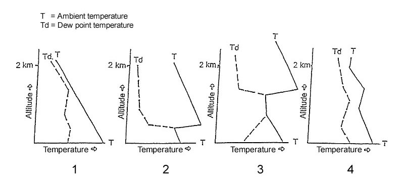
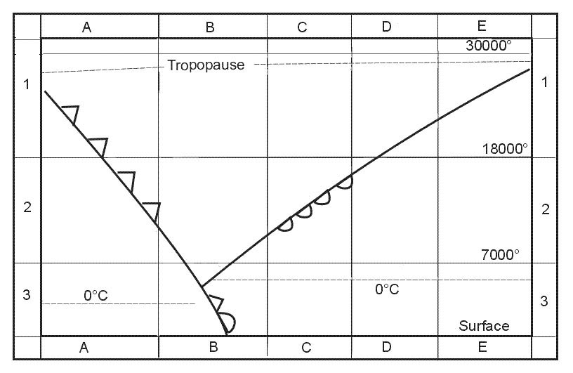
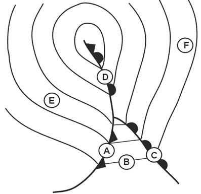
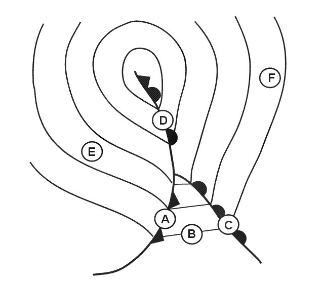
Question 162-33 : Of the four radio soundings select the one that indicates ground fog 255 ?
N°2.
When temperature and dew point are equals the air is satured and condensed water droplets will form cloud or for radio sounding n°2 indicates ground fog at the surface radio sounding n°3 indicates that a layer of cloud is present above the surfaceN°1. n°3. n°4.
Question 162-34 : Which of the following cloud types can project up into the stratosphere ?
Cumulonimbus.
503cumulonimbus clouds are the tallest clouds and can reach to the stratosphere the updraft in some strong cbs will bulge into the stratosphereCirrostratus. altocumulus. altostratus.
Question 162-35 : What process in an air mass leads to the creation of wide spread ns and as cloud coverage ?
Lifting.
Lifting is a process leading to the creation of thin nimbostratus and altostratus cloud layer sinking will lead to the dissipation of clouds radiation will also dissipate clouds or generate a convective activity and will create cumulus clouds not ns or asSinking. convection process. radiation.
Question 162-36 : Which of the following cloud is classified as low level cloud ?
St.
503Cs as cc
Question 162-37 : Which of the following is most likely to lead to the dissipation of radiation fog ?
A marked increase in wind velocity near the ground.
A marked decrease in wind velocity close to the ground ground cooling caused by radiation during the night a build up of a high pressure area resulting in adiabatic warming associated with a sinking air mass
Question 162-38 : Which of the following conditions is most likely to lead to the formation of steam fog arctic smoke ?
Cold air moving over warm water.
Steam fog also known as steaming fog evaporation fog frost smoke or arctic sea smoke occurs when evaporation takes place into cold air lying over warmer water 569it is named by analogy with the condensed vapor or steam which appears above water which is heated invisible vapor is given off from the water but is almost immediately recondensed as it comes into contact with the colder air the air has to be much colder than the water so that convection currents develop formation also requires that there is a marked surface temperature inversion in the air before it moves over the sea or inland water bodies so as to preclude the lapse rate becoming unstable through a deep layer a low air temperature typically 0°c or below so that a comparatively small amount of moisture can produce supersaturation otherwise the heating process will outweigh the tendency towards saturationbecause of these requirements this type of fog is usually only formed over water surfaces near to a source of cold air such as frozen ground or ice sheets in polar regions one classic occurrence is following the sudden break up of sea ice to expose relatively warm water in the steep sided fjords along parts of the icelandic and norwegian coasts and similar environments elsewhere steam fog may reach a depth of 500 feet or more and drift over adjacent land areas whilst relatively rare in temperate latitudes cold air which collects in and then drifts down large river valleys and out over a relatively warm sea surface in very light wind conditions can occasionally lead to the formation of smaller and much shallower areas of this type of fog in winterWarm air moving over cold water the sea is warmed by strong radiation from the sun the coastal region of the sea cools at night
Question 162-39 : The lowest cloud base forecast at eta zurich 1200 utc is lszh 061019 20018g30kt 9999 ra sct050 bkn080 tempo 23012kt 6000 dz bkn015 bkn030 becmg 1518 23020g35kt 4000 ra ovc010= ?
1500 ft.
Lszh 061019 20018g30kt 9999 ra sct050 bkn080 tempo 23012kt 6000 dz bkn015 bkn030 becmg 1518 23020g35kt 4000 ra ovc010=the tempo group is used for any conditions in wind visibility weather or sky condition which are expected to last for generally less than an hour at a time occasional and are expected to occur during less than half the time period at 1200 utc the lowest cloud base forecast is 1500 ftthe most likely cloud base forecast will be 8000 ft bkn080 between 1000 utc to 1500 utcnote a cloud base is few or sct a cloud ceiling is bkn or ovc1000 ft. 2500 ft. 5000 ft.
Question 162-40 : Extensive cloud and precipitation is often associated with a non frontal thermal depression because of ?
Surface convergence and upper level divergence causing widespread ascent of air in the depression.
532the cloud is caused by ascending air with divergence at height and convergence at the surfaceSurface convergence and upper level divergence causing widespread descent of air in the depression. surface divergence and upper level convergence causing widespread descent of air in the depression. surface divergence and upper level convergence causing widespread ascent of air in the depression.
Exclusive rights reserved. Reproduction prohibited under penalty of prosecution.