A free Premium account on the FCL.055 website! Read here
Sign up to unlock all our services and 15164 corrected and explained questions.
Question 163-1 : Which of the following meteorological phenomenon indicates upper level instability which may lead to thunderstorm development ? [ Formation assignment ]
Ac castellanus
Question 163-2 : Which type of fog is likely to form when air having temperature of 15°c and dew point of 12°c blows at 10 knots over a sea surface having temperatures of 5°c ?
Advection fog.
Advection fog warm moist air mass moving over a cold surface without too much windradiation fog forms due to surface cooling at night in a light windsteaming fog is the same as arctic smoke or sea smoke and is caused by cold air moving over a warm surfaceadvection fog forms when warm humid air flows over a cold surfacefrontal fog is most likely to occur in advance of a warm front it is due to the rain falls from the warm air into the cold airRadiation fog. steam fog. frontal fog.
Question 163-3 : What type of fog is most likely to form over flat land during a clear night with calm or light wind conditions ?
Radiation.
Radiation fog forms due to surface cooling at night in a light windsteaming fog is the same as arctic smoke or sea smoke and is caused by cold air moving over a warm surfaceadvection fog forms when warm humid air flows over a cold surfacefrontal fog is most likely to occur in advance of a warm front it is due to the rain falls from the warm air into the cold airOrographic. advection. steam.
Question 163-4 : Which types of clouds are typical evidence of stable air conditions ?
St as.
Strat = stabilityCu, cb ns, cu cb, cc
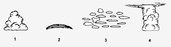
Question 163-5 : Which one of the displayed cloud forms is representative of altocumulus lenticularis 295 ?
N°2.
N°4. n°1. n°3.
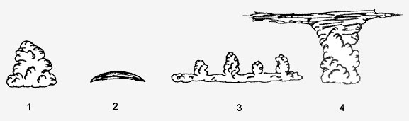
Question 163-6 : Which one of the displayed cloud forms is representative of a cumulonimbus capillatus 296 ?
N°4.
As the cumulonimbus cloud grows in size it may turn into a cumulonimbus capillatus which means that it gains a fibrous edged top 640a clearly developed cumulonimbus capillatus displaying the classic anvil shapeN°3. n°2. n°1.
Question 163-7 : A plain in western europe with an average height of 500 m 1600 ft above sea level is covered with a uniform sc layer of cloud during the summer months at what height above the ground is the base of this cloud to be expected ?
1500 7000 ft above ground.
503stratocumulus are low level cloudsduring the summer months the land warms up and the cloud base goes up this is the reason why sc will not be found below 1500 ft100 - 1500 ft above ground. 7000 - 15000 ft above ground. 15000 - 25000 ft above ground.
Question 163-8 : A plain in western europe with an average height of 500 m 1600 ft above sea level is covered with a uniform cc layer of cloud during the summer months at what height above the ground is the base of this cloud to be expected ?
15000 35000 ft above the terrain.
Cirrocumulus cc are high level clouds 503the base of the layer can be expected between 15000 ft up to 35000 ft7000 - 15000 ft above the terrain. 1500 - 7000 ft above the terrain. 100 - 1500 ft above the terrain.
Question 163-9 : Which of the following cloud types is found at high levels ?
Ci.
503Sc. as. cu.
Question 163-10 : Which of the following cloud types is a medium level cloud ?
As.
503Cs. st. sc.
Question 163-11 : Under which of these conditions is radiation fog most likely to form ?
Little or no cloud.
Radiation fog forms due to surface cooling at night in a light windsteaming fog is the same as arctic smoke or sea smoke and is caused by cold air moving over a warm surfaceadvection fog forms when warm humid air flows over a cold surfacefrontal fog is most likely to occur in advance of a warm front it is due to the rain falls from the warm air into the cold airVery dry air. strong surface winds. very low temperatures.
Question 163-12 : Which of the following is most likely to lead to the formation of radiation fog ?
Heat loss from the ground on clear nights.
Radiation fog forms due to surface cooling at night in a light windsteaming fog is the same as arctic smoke or sea smoke and is caused by cold air moving over a warm surfaceadvection fog forms when warm humid air flows over a cold surfacefrontal fog is most likely to occur in advance of a warm front it is due to the rain falls from the warm air into the cold airDry, warm air passing over warm ground the passage of fronts cold air passing over warm ground
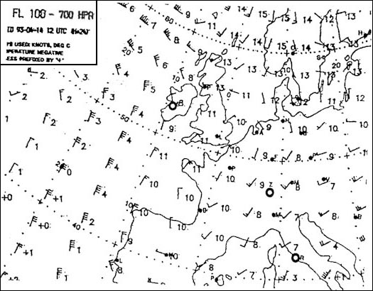
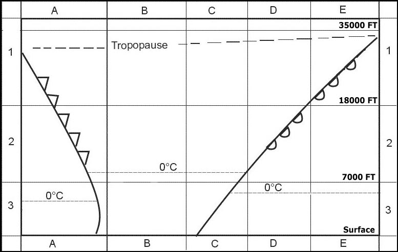
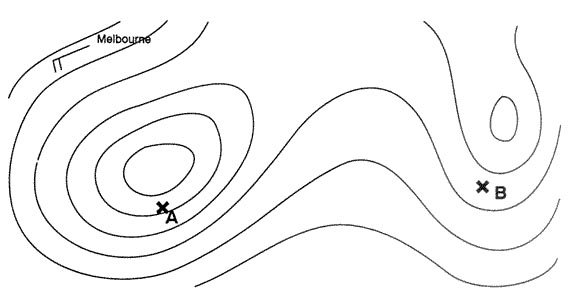
Question 163-13 : Of the four radio soundings select the one that indicates low stratus 298 ?
N°3.
When temperature and dew point are equals the air is satured and condensed water droplets will form cloud or fog radio sounding n°2 indicates ground fog at the surface radio sounding n°3 indicates that a layer of cloud is present above the surfaceN°1. n°2. n°4.
Question 163-14 : In which of the following metar reports is the probability of fog formation in the coming night the highest ?
Light wind below 5 kt little or no cloud clear night only one degree between temperature and dew pointvisibilty will fall from 6000 m to 1600 m and br mist indicates moist airthis conditions will lead to the formation of radiation fog moist air over land with heat loss from the ground on clear nights 201850z 21003kt 8000 sct250 12/m08 q1028 nosig= 201850z 06018g30kt 5000 -ra ovc010 04/01 q1024 nosig= 201850z 25010kt 4000 ra bkn012 ovc030 12/10 q1006 tempo 1500=
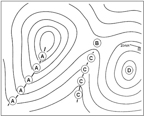
Question 163-15 : Which airport is most likely to have fog in the coming night 302 ?
Lszh.
Radiation fogs occur at night and usually do not last long after sunrise radiation fog is common in autumn and early winter north hemisphere radiation fog is formed by the cooling of land after sunset by thermal radiation in calm conditions with clear skythe cool ground produces condensation in the nearby air by heat conduction in the next 8 hours ekch engm and essa will be covered by the second perturbation arriving from the west with winds rains and cloudsonly zurich airport lszh will remains clear from the bad weather area allowing radiation fog developmentEnfb. ekch. essa.
Question 163-16 : Which of the following cloud types are most likely to produce light to moderate icing when they are not subject to orographic lifting and consist of supercooled cloud droplets ?
Altocumulus and altostratus.
Cirrocumulus and cirrostratus are high altitude clouds no supercooled cloud dropletscumulonimbus it produces light moderate and severe icingit remains only the 'altos' altocumulus and altostratusStratocumulus and cirrostratus stratus and cumulonimbus altostratus and cirrocumulus
Question 163-17 : Altostratus clouds are classified as ?
Medium level clouds.
503Low level clouds high level clouds convective clouds
Question 163-18 : A cumulonimbus cloud at mid latitudes in summer contains ?
Ice crystals water droplets and supercooled water droplets.
Only water droplets only ice crystals ice crystals and water droplets but never supercooled water droplets
Question 163-19 : Strongly developed cumulus clouds are an indication of ?
Instability in the atmosphere.
The presence of a low level inversion. poor surface visibility. the presence of warm air aloft.
Question 163-20 : Clouds classified as being low level are considered to have bases from ?
The surface to 6500 ft.
5031000 to 2000 ft. 500 to 1000 ft. 100 to 200 ft.
Question 163-21 : Which of the following are medium level clouds ?
Altostratus and altocumulus.
503Cirrocumulus and cirrostratus. cumulonimbus. all convective clouds.
Question 163-22 : Cumulus clouds are an indication for ?
Up and downdrafts.
It means instabilityStability. the approach of a cold front. the approach of a warm front.
Question 163-23 : A generally grey cloud layer with fairly uniform base and uniform appearance which may give drizzle or snow grains when the sun is visible through the cloud the outline is clearly discernible sometimes it appears in the form of ragged patcheswhat type of cloud is being described ?
Stratus.
Altostratus. nimbostratus. cirrostratus.
Question 163-24 : The presence of altocumulus castellanus indicates ?
Instability in the middle troposphere.
Strong convection at low height. stability in the higher troposphere. subsidence in a large part of the troposphere.
Question 163-25 : In an area of converging air in low level ?
Clouds can be formed.
563divergence in the upper air means convergence on the ground this a low pressure area and clouds may appears above itConvective clouds can be dissolved. stratified clouds can be dissolved. clouds can not be formed.
Question 163-26 : When the temperature and dew point are less than one degree apart the weather conditions are most likely to be ?
Fog or low cloud.
Clear and cool. high scattered clouds. unlimited visibility.
Question 163-27 : The morning following a clear calm night when the temperature has dropped to the dewpoint is likely to produce ?
Radiation fog.
Radiation fog forms due to surface cooling at night in a light windsteaming fog is the same as arctic smoke or sea smoke and is caused by cold air moving over a warm surfaceadvection fog forms when warm humid air flows over a cold surfacefrontal fog is most likely to occur in advance of a warm front it is due to the rain falls from the warm air into the cold airA cold front. advection fog. good clear weather.
Question 163-28 : Advection fog can be formed when ?
Warm moist air flows over a colder surface.
Advection fog warm moist air mass moving over a cold surface without too much windradiation fog forms due to surface cooling at night in a light windsteaming fog is the same as arctic smoke or sea smoke and is caused by cold air moving over a warm surfaceadvection fog forms when warm humid air flows over a cold surfacefrontal fog is most likely to occur in advance of a warm front it is due to the rain falls from the warm air into the cold airCold moist air flows over a warmer surface. warm moist air flows over a warmer surface. cold moist air flows over warmer water.
Question 163-29 : Steaming fog arctic sea smoke occurs in air ?
With cold mass properties.
Steam fog also known as steaming fog evaporation fog frost smoke or arctic sea smoke occurs when evaporation takes place into cold air lying over warmer water 569it is named by analogy with the condensed vapor or steam which appears above water which is heated invisible vapor is given off from the water but is almost immediately recondensed as it comes into contact with the colder air the air has to be much colder than the water so that convection currents develop formation also requires that there is a marked surface temperature inversion in the air before it moves over the sea or inland water bodies so as to preclude the lapse rate becoming unstable through a deep layer a low air temperature typically 0°c or below so that a comparatively small amount of moisture can produce supersaturation otherwise the heating process will outweigh the tendency towards saturationbecause of these requirements this type of fog is usually only formed over water surfaces near to a source of cold air such as frozen ground or ice sheets in polar regions one classic occurrence is following the sudden break up of sea ice to expose relatively warm water in the steep sided fjords along parts of the icelandic and norwegian coasts and similar environments elsewhere steam fog may reach a depth of 500 feet or more and drift over adjacent land areas whilst relatively rare in temperate latitudes cold air which collects in and then drifts down large river valleys and out over a relatively warm sea surface in very light wind conditions can occasionally lead to the formation of smaller and much shallower areas of this type of fog in winterWith warm mass properties. that is absolutely stable. that is stable.
Question 163-30 : Frontal fog is most likely to occur ?
In advance of a warm front.
The passage of a warm front can be associated with areas of fog the types of fog just in advance of a warm front is frontal fog and just after the passage is advection fog frontal fog is caused by the additional moisture in the air due to the evaporation of rain or drizzlethe different types of fog radiation fog forms due to surface cooling at night in a light windsteaming fog is the same as arctic smoke or sea smoke and is caused by cold air moving over a warm surfaceadvection fog forms when warm humid air flows over a cold surfacefrontal fog is most likely to occur in advance of a warm front it is due to the rain falls from the warm air into the cold airIn rear of a warm front. in summer in the early morning. in winter in the early morning.
Question 163-31 : Freezing fog exists if fog droplets ?
Are supercooled.
Are frozen. are freezing very rapidly. freeze when temperature falls below zero.
Question 163-32 : Which of the following circumstances most favour the development of radiation fog ?
Moist air over land during clear night with little wind.
Warm moist air at the windward side of a mountain maritime tropical air flowing over cold sea advection of very cold air over much warmer sea
Question 163-33 : Fallstreaks or virga are ?
Water or ice particles falling out of a cloud that evaporate before reaching the ground.
2542Strong downdraughts in the polar jet stream, associated with jet streaks. gusts associated with a well developed bora. strong katabatic winds in mountainous areas and accompanied by heavy precipitation.
Question 163-34 : The range of wind speed in which radiation fog is most likely to form is ?
Below 5 kt.
Between 10 and 15 kt. between 5 and 10 kt. above 15 kt.
Question 163-35 : At the top of orographic waves in mountainous regions the cloud most likely to be encountered is ?
Altocumulus lenticularis.
433 2540Cirrostratus. cirrus. cumulus mediocris.
Question 163-36 : A cumulus congestus is ?
A cumulus that is of great vertical extent.
A remnant of a cb. a cumulus with little vertical development. a cumulus that only occurs in association with the itcz.
Question 163-37 : Clouds in patches sheets or grey or whitish layers made up of elements resembling large pebbles or rollers together or not and always clear of the ground are ?
Stratocumulus.
597Stratus. altostratus. nimbostratus.
Question 163-38 : In mid latitudes the tops of cumulus are often limited by ?
A temperature inversion.
Their growth is usually limited by a temperature inversion which is marked by the unusually uniform height of the clouds also called fair weather cumulusA layer of unstable air. a radiation inversion. the tropopause.
Question 163-39 : Of what does lenticular cloud provide evidence ?
Mountain waves.
Jet streams. stratospheric inversions. areas of high level clear air turbulence.
Question 163-40 : The formation of morning fog before sunrise is possible if ?
Air temperature and dew point are equal or close to one another.
The wind is strong. the sky is overcast. the turbulence in the lower layers is moderate.
Exclusive rights reserved. Reproduction prohibited under penalty of prosecution.