A free Premium account on the FCL.055 website! Read here
Sign up to unlock all our services and 15164 corrected and explained questions.
Question 164-1 : What is the difference between radiation fog and advection fog ? [ Formation assignment ]
Radiation fog forms due to surface cooling at night in a light wind advection fog forms when warm humid air flows over a cold surface
Question 164-2 : When fog is reported the visibility is below ?
1 km.
Mist is defined as visibility between 1 and 5 kilometersbelow 1 km we talk about fog0.8 km. 1.5 km. 3 km.
Question 164-3 : When visibility is reduced by water droplets to less than 1000 metres it is classified as ?
Fog.
Mist is defined as visibility between 1 and 5 kilometersbelow 1 km we talk about fogDust fog. drizzle. mist.
Question 164-4 : Which cloud type may indicate the presence of severe turbulence ?
Altocumulus lenticularis.
Stratocumulus nimbostratus. cirrocumulus.
Question 164-5 : Which is true of advection fog ?
It can appear suddenly by day or by night.
Advection fog forms when warm humid air flows over a cold surface so it can appear suddenly by day or by night when a warm front is comingradiation fog forms due to surface cooling at night in a light windsteaming fog is the same as arctic smoke or sea smoke and is caused by cold air moving over a warm surfaceadvection fog forms when warm humid air flows over a cold surfacefrontal fog is most likely to occur in advance of a warm front it is due to the rain falls from the warm air into the cold airIt develops slowly and clears fast. it forms when unstable air is adiabatically cooled. it usually forms by night and clears by day.
Question 164-6 : Which of the following sets of conditions are most likely to lead to the formation of advection fog ?
A mild moist airstream flowing over colder surfaces with the wind speed less than 15 kt.
Advection fog forms when warm humid air flows over a cold surface as wind speed increases there is more likelihood of turbulence cloud formingadvection fog forms when warm humid air flows over a cold surfaceradiation fog forms due to surface cooling at night in a light windsteaming fog is the same as arctic smoke or sea smoke and is caused by cold air moving over a warm surfacefrontal fog is most likely to occur in advance of a warm front it is due to the rain falls from the warm air into the cold airClear skies at night over an inland marshy area. a mild moist airstream flowing over colder surfaces with a wind in excess of 30 kt. cold maritime air flowing over a warmer land surface at a speed greater than 15 kt.
Question 164-7 : Which of the following types of cloud can extend over the low medium and high cloud levels ?
Cb.
503Ac. st. ci.
Question 164-8 : Which of the following types of clouds are evidence of unstable air conditions ?
Cu cb.
St, cs. sc, ns. ci, sc.
Question 164-9 : Which type of fog can not be formed over water ?
Radiation fog.
Radiation fog forms due to surface cooling at night in a light windsteaming fog is the same as arctic smoke or sea smoke and is caused by cold air moving over a warm surfaceadvection fog forms when warm humid air flows over a cold surfacefrontal fog is most likely to occur in advance of a warm front it is due to the rain falls from the warm air into the cold airAdvection fog. arctic smoke. frontal fog.
Question 164-10 : Stratus formed by turbulence will occur when ?
In the friction layer mixing occurs by turbulence and the condensation level is situated below the top of the turbulent layer.
Turbulence cloud is formed within the turbulence layer because mixing of the air modifies the temperatureThe wind speed is less than 10 kt and the air is heated by the earth's surface. the wind speed is greater than 10 kt and the condensation level is situated just above the turbulent layer. absolute instability exists at low level.
Question 164-11 : Radiation fog most frequently occurs in ?
High pressure systems over land.
Low pressure systems over sea. high pressure systems over sea. low pressure systems over land.
Question 164-12 : What kind of fog is often observed in the coastal region of newfoundland in spring time ?
Advection fog.
Advection of warm air over a cold surface => the air will cool by bellow ==> advection fogindication = coastal regionwarm and moist air from the sea is traveling over the cold surface of the coast => advection fogFrontal fog. radiation fog. steaming fog.
Question 164-13 : Which statement is correct ?
Fog can be supercooled and can also contain ice crystals.
Mist and haze consist of water droplets. fog and haze do not occur in the tropics. mist and haze only differ by different values of visibility.
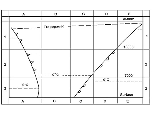
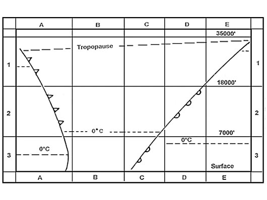
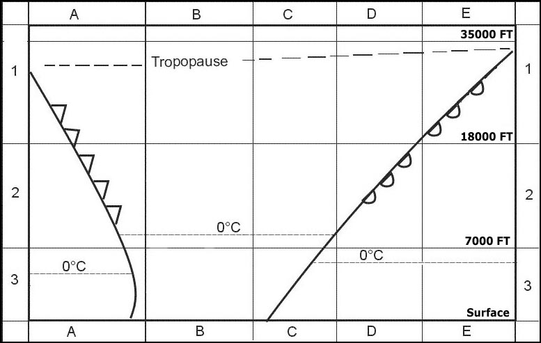
Question 164-14 : The cloud type most applicable to square 3c is 355 ?
Ns.
559Cb. ac. as.
Question 164-15 : The cloud type most applicable to square 2d is 356 ?
As.
Square 2d 7000 ft to 18000 ft 622the most applicable cloud type are ns and asCu. cb. cs.
Question 164-16 : The cloud most likely to be experienced in square 1e is 357 ?
Ci.
The magic drawing 622we can exclude ac and as above 18000 ft cb will be met after a cold frontAc. as. cb.
Question 164-17 : If radiation fog forms on a clear night with light winds the increase in wind speed from 5 kt to 13 kt will most likely ?
Cause the fog to lift and become low stratus.
Change the radiation fog to advection fog. have no effect. disperse the fog immediately.
Question 164-18 : Clouds will mainly consist of supercooled water droplets when the temperature is ?
Between 0°c and 15°c.
Between -5°c and -30°c. between -30°c and -40°c. below -40°c.
Question 164-19 : Frontal fog can be formed by ?
Condensation of air saturated by evaporation of precipitation.
Condensation of air saturated by adiabatic cooling. cooling at night. evaporation of moisture at the surface.
Question 164-20 : Advection of very cold air over a warm sea current can cause ?
Steaming fog.
Steaming fog is the same as arctic smoke or sea smoke and is caused by cold air moving over a warm surfaceradiation fog forms due to surface cooling at night in a light windadvection fog forms when warm humid air flows over a cold surfacefrontal fog is most likely to occur in advance of a warm front it is due to the rain falls from the warm air into the cold airAdvection fog. no fog at all. frontal fog.
Question 164-21 : As a result of diurnal variation radiation fog is lifted and a cloud cover is formed which statement is true ?
Low stratus will develop caused by increasing wind speed.
Radiation fog occurs over land most commonly inland on clear moist nights when the wind speed is less than about 5 kt it forms after sunset as the wet ground begins to cool producing condensation in the nearby airmorning solar radiation heats the ground this generates increasing wind above the radiation fog entrains drier air and accelerates the dissipationnote in summer radiation fog layers are most often thin due to short nights in the winter however under stationary synoptic situations radiation fog can last for daysLow stratus will develop caused by radiation in combination with low geostrophic wind speed. layers of altocumulus will develop caused by increasing wind speed. stratocumulus will develop caused by insolation.
Question 164-22 : In which situation is advection fog most likely to form ?
An air mass moving inland from the coast in winter.
This mass of air is relatively warm and full of moisture will be cooled by bellow by contact with the inland cold ground condensation will occur and advection fog will be createdA warm moist air mass on the windward side of the mountains. a light breeze blowing colder air out to sea. warm moist air settling over a warmer surface under no-wind conditions.
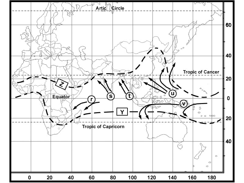
Question 164-23 : About ten identical clouds are in the sky well isolated from one another dense with well defined contours developping vertically in a cauliflower shape the side of these clouds lit by the sun is bright white their base relatively dark is essentially horizontal and at fl 30 and their tops at fl ?
Question 164-24 : Which of the following cloud types is classified as low level cloud ?
Sc.
Cqb15 july 2011sc stratocumulus low level cs cirrostratus high level as altostratus medium level ac altocumulus medium level As. ac. cs.
Question 164-25 : Which of the following cloud types is found at high level ?
Cs.
Cqb15 july 2011cs cirrostratus high level sc stratocumulus low level st stratus low level ac altocumulus medium level 503Sc. ac. st.
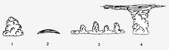
Question 164-26 : Which one of the displayed cloud forms is representative of a cumulus 375 ?
1.
Cqb15 august 20112. 3. 4.
Question 164-27 : Which one of the following cloud types can be characterised by the optical phenomenon called halo ?
Cirrostratus.
635they are produced by the ice crystals in cirrus clouds high the particular shape and orientation of the crystals is responsible for the type of halo observed light is reflected and refracted by the ice crystals and may split up into colors because of dispersion the crystals behave like prisms and mirrors refracting and reflecting sunlight between their faces sending shafts of light in particular directionsAltocumulus. cumulonimbus. nimbostratus.
Question 164-28 : Which cloud type genus is described by the following definition 'greyish or bluish cloud sheet or layer of striated fibrous or uniform appearance totally or partly covering the sky and having parts thin enough to reveal the sun at least vaguely as through ground glass this genus does not show halo ?
Altostratus.
cirrus ci detached clouds in the form of white dedicate filaments or white or mostly white patches or narrow bands these clouds have fibrous hair like appearance or a silky sheen or both cirrocumulus cc thin white patch sheet or layer of cloud without shading composed of very small elements in the form of grains ripples etc merged or separate and more or less regularly arranged most of the elements have an apparent width of less than one degree cirrostratus cs transparent whitish cloud veil of fibrous hair like or smooth appearance totally or partly covering the sky and generally producing halo phenomena altostratus as greyish or bluish cloud sheet or layer of striated fibrous or uniform appearance totally or partly covering the sky and having parts thin enough to reveal the sun at least vaguely as through ground glass altostratus cloud does not show halo phenomena altocumulus ac white or grey or both white and grey patch sheet or layer of cloud generally with shading composed of laminae rounded masses rolls etc which are sometimes partly fibrous or diffuse and which may or may not be merged most of the regularly arranged small elements usually have an apparent width of between one and five degrees nimbostratus ns grey cloud layer often dark the appearance of which is rendered diffuse by more or less continuously falling rain or snow which in most cases reaches the ground it is thick enough throughout to blot out the sun stratocumulus sc grey or whitish or both grey and whitish patch sheet or layer of cloud which almost always has dark parts composed of tessellations rounded masses rolls etc which are non fibrous except for virga and which may or may not be merged most of the regularly arranged small elements have an apparent width of more than five degrees stratus st generally grey cloud layer with a fairly uniform base which may give drizzle ice prisms or snow grains when the sun is visible through the cloud its outline is clearly discernible stratus does not produce halo phenomena except possible at very low temperatures cumulus cu detached clouds generally dense and with sharp outlines developing vertically in the form of rising mounds domes or towers of which the bulging upper parts often resembles a cauliflower the sunlit parts of these clouds are mostly brilliant white their base is relatively dark and nearly horizontal cumulonimbus cb heavy and dense cloud with a considerable vertical extent in the form of a mountain or huge towers at least part of its upper portion is usually smooth or fibrous or striated and nearly always flattened this part often spreads out in the shape of an anvil or vast plume under the base of this cloud which is often very dark there are frequently low ragged clouds ether merged with it or not and precipitation sometimes in the form of virgaalto means height or upper air in meteorological context = medium levelcirro from which cirrus is obtained means 'wisp of hair'cumulo from which cumulus is obtained means 'heap' clouds with this designator appear to be piled up these type clouds form in unstable layers of air the initial lifting may be due to convective lifting or forced mechanical lifting such as orographic frontal or convergence lifting if the layer is unstable the air parcel will continue to rise producing a cumulo form cloudnimbo means 'rain' thus nimbostratus and cumulonimbus are clouds from which precipitation occursstrato from which stratus is obtained means 'layer' or 'layered' clouds with this designator form in stable layers of air except the stratocumulus type which forms in a thin unstable layer of airCirrostratus. stratus. stratocumulus.
Question 164-29 : What cloud type can produce freezing rain ?
Nimbostratus.
Img505Stratus. cumulonimbus. stratocumulus.
Question 164-30 : Frontal fog is most likely to dissipate ?
After the passage of a warm front.
The question asks for 'dissipation' of the frontal fog not how it occurs frontal fog is likely to occur in advance of a warm front due to rain falls from warm air to cold airfrontal fog is most likely to dissipate after the passage of a warm frontIn advance of a warm front. when the wind decreases. when the wind veers.
Question 164-31 : Which of the following situations will most likely lead to a stable air mass ?
Subsidence andor cooling from below.
Cold air at higher levels and advection of warm air at lower levels. widespread convection. decreasing wind and developing showers.
Question 164-32 : Which cloud species is described by the following definition 'clouds which present in at least some portion of their upper part cumuliform protuberances in the form of turrets which generally give the clouds a crenellated appearance the turrets some of which are taller than they are wide are ?
Castellanus.
Calvus. fractus. congestus.
Question 164-33 : Which of the following processes contributes to the formation of frontal fog ?
Rain falls from the warm air into the cold air.
Very cold air flows over much warmer sea. moist air flows over land during a clear night. maritime polar air flows over a warm ground.
Question 164-34 : Which cloud species is described by the following definition 'cumulonimbus characterised by the presence mostly in its upper portion of distinct cirriform parts of clearly fibrous or striated structure frequently having the form of an anvil a plume or a vast more or less disorderly mass of hair this ?
Capillatus.
As the cumulonimbus cloud grows in size it may turn into a cumulonimbus capillatus which means that it gains a fibrous edged top 640a clearly developed cumulonimbus capillatus displaying the classic anvil shapeCalvus. fractus. congestus.
Question 164-35 : Which of the following statements is true concerning orographic fog ?
It may be formed by day as well as by night.
The most likely conditions which contribute to the formation of orographic fog hill fog are humid stable air mass and wind blowing towards the hills orographic fog may be formed by day as well as by nightIt forms suddenly by day but not by night. it is formed when the air is unstable. it develops slowly and dissipates rapidly.
Question 164-36 : Which cloud type genus is described by the following definition 'detached clouds in the form of white delicate filaments or white or mostly white patches or narrow bands these clouds have fibrous hair like appearance or a silky sheen or both' ?
Question 164-37 : The main components of a cirrostratus are ?
Ice crystals.
Ice crystals and water droplets. water droplets. water droplets and water vapour.
Question 164-38 : Which of the following circumstances most favours the development of orographic fog ?
High relative humidity.
Ecqb01 2013the most likely conditions which contribute to the formation of orographic fog hill fog are humid stable air mass and wind blowing towards the hills orographic fog may be formed by day as well as by nightAbsolutely unstable air. katabatic winds. clear nights.
Question 164-39 : The main components of an altostratus are ?
Ice crystals and water droplets.
Ecqb01 2013Water droplets and snow grains. water droplets and water vapour. ice crystals and ice pellets.
Question 164-40 : Which of the following cloud types is found at high level ?
Cc.
Ecqb01 2013cc cirrocumulus high level sc stratocumulus low level st stratus low level ac altocumulus medium level 503St ac sc
Exclusive rights reserved. Reproduction prohibited under penalty of prosecution.