A free Premium account on the FCL.055 website! Read here
Sign up to unlock all our services and 15164 corrected and explained questions.
Question 165-1 : In wintertime stratus is often formed when warm maritime air moves over cold land how can such clouds be classified ? [ Formation assignment ]
Turbulence clouds
Question 165-2 : Which cloud type 'genus' is described by the following definition 'grey cloud layer often dark the appearance of which is rendered diffuse by more or less continuously falling rain or snow which in most cases reaches the ground it is thick enough throughout to blot out the sun low ragged clouds ?
Nimbostratus.
Ecqb01 june 2013Altostratus. stratus. stratocumulus.
Question 165-3 : Which cloud type 'genus' is described by the following definition 'cumulus clouds which are markedly sprouting and are often of great vertical extent their bulging upper part frequently resembles a cauliflower' ?
Towering cumulus.
Ecqb01 june 2013Cumulonimbus capillatus. cumulus fractus. cumulus humilis.
Question 165-4 : Which of the following statements is true concerning frontal fog ?
It may be formed by day as well as by night.
Ecqb01 june 2013It usually forms by night. it develops rapidly and dissipates slowly. it usually forms by day.
Question 165-5 : Which of the following statements is true concerning orographic fog ?
It is formed when air is forced to rise up a slope.
Easa 2014the most likely conditions which contribute to the formation of orographic fog hill fog are humid stable air mass and wind blowing towards the hills orographic fog may be formed by day as well as by nightIt usually forms by night. it develops when air is descending down a slope. it usually forms by day.
Question 165-6 : Which of the following cloud types will most probably form when cold moist air moves over a warm surface ?
Cumulus.
Easa 2014over a warm surface a cold air will be heated by convection lower layer will rise and increase instability this will lead to the formation of cumulus and possible cumulonimbus with sometime severe thunderstormsStratocumulus. nimbostratus. stratus.
Question 165-7 : Which of the following clouds may extend into more than one étage ?
Cumulus congestus.
As strange as the easa can be french word 'étage' with its acute accent has been used at the exam instead of 'level' referring to low medium and high level clouds classification Cirrocumulus. altocumulus. stratus.
Question 165-8 : Which of the following circumstances most favours the development of frontal fog ?
Increase of the relative humidity by evaporation of rain drops.
Revised ecqb03 august 2016frontal fog is most likely to occur in advance of a warm front it is due to the rain falls from the warm air into the cold airfrontal fog can be formed by condensation of air saturated by evaporation of precipitationsteaming fog is the same as arctic smoke or sea smoke and is caused by cold air moving over a warm surfaceadvection fog forms when warm humid air flows over a cold surfaceradiation fog forms due to surface cooling at night in a light windAdvection of very cold air over much warmer sea. nocturnal radiation. absolutely unstable air.
Question 165-9 : Where does one normally find the highest cloud tops ?
In a tropical cyclone.
Ecqb03 august 2016In a cold front. in a polar low. near an occlusion point.
Question 165-10 : The frontal or mixing fog results from the meeting of ?
A warm and very humid air mass with a cold and very humid air mass.
A warm and very dry air mass with a cold and very dry air mass. a warm and very humid air mass with a cold and dry air mass. a cold and very humid air mass with a cold and dry air mass.
Question 165-11 : What wind conditions occurring just before dawn favour the formation of fog at an airport where the temperature is 15°c and the dew point is 14°c ?
Calm.
Easterly, 10 kt. northerly, 10 kt. westerly, 10 kt variable.
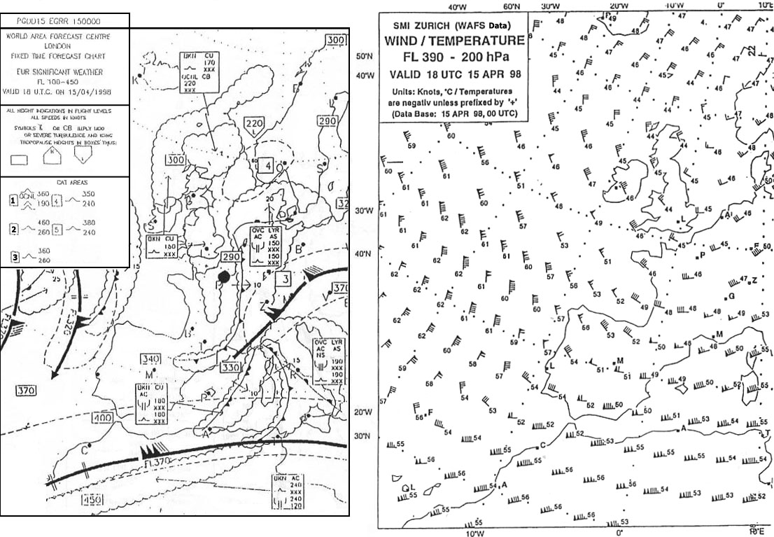
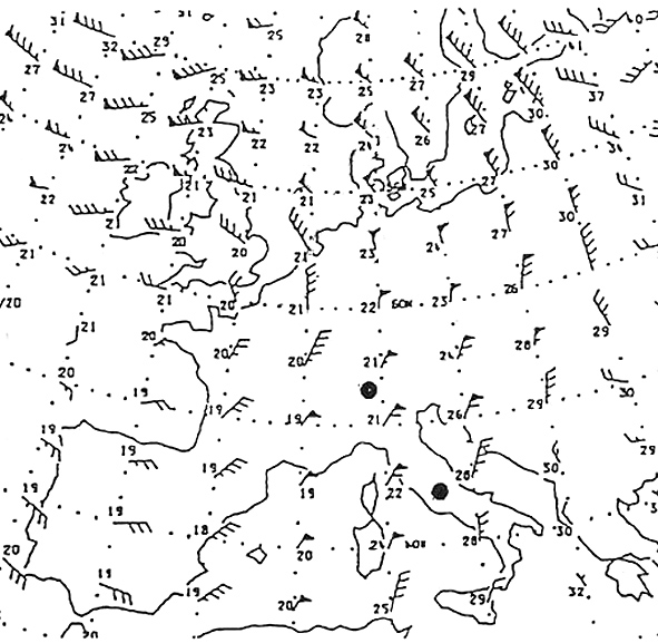
Question 165-12 : If you are flying from zurich to stockholm at fl 240 what conditions can you expect at cruising altitude 400 ?
Out of cloud throughout the flight.
The questions states at cruising altitude fl240 only at this level you are out of cat area out of clud top of clouds is at fl150 and there is no scattered thunderstormsLargely free of cloud, moderate icing half way along the route. scattered thunderstorms. cloud most of the way, little chance of cat.
Question 165-13 : In which cloud type does moderate to severe airframe icing most probably occur ?
In nimbostratus clouds.
Airframe icing will not happen in cirrus cloud composed of ice crystals or if the temperature is above 0ºc ns nimbostratus produces heavy rain if the rain falls through a cold air mass below the freezing level moderate to severe airframe icing can occurin clear air you can only have light icingIn stratus clouds. in clouds containing ice crystals. in altostratus clouds.
Question 165-14 : Which of the following clouds represents the most stable air mass ?
Question 165-15 : A frontal depression passes through the airport what form of precipitation do you expect ?
Continuous rain or snow during 6 hours until the warm front arrives the precipitation stops for several hours within the warm sector on the arrival of the cold front showers within a couple of hours.
Continuous rain or snow while the frontal wave passes for a period of some 24 hours. showers during some 2 hours until the warm front arrives. drizzle in the warm sector within 12 hours. rain or snow on the passage of the cold front. rain or snow during about 12 hours until the warm front arrives. within the warm sector the rain increases. improvement on the passage of the cold front.
Question 165-16 : Which of the following are favourable conditions for the formation of freezing rain ?
Warm air aloft from which rain is falling into air with a temperature below 0°c.
Freezing rain is associated with warm fronts and warm occlusions in a warm front the freezing level is lower than behind in the warm sector and the slope means that freezing rain will be falling on anything underneath so if you are flying towards a warm front or warm occlusion watch out supercooled water droplets from above will freeze onto your cold airframe once you see ice pellets expect freezing rain next 505Water droplets falling from cold air aloft with a temperature below 0°c into air with a temperature above 0°c. cold air aloft from which hail is falling into air that is warm. an isothermal layer aloft with a temperature just above 0°c through which rain is falling.
Question 165-17 : Which form of precipitation from clouds containing only water is most likely to fall in mid latitudes ?
Drizzle.
Large waterdropplets will only form in clouds with large vertical extent and most likely also contain icesince this cloud only contains water it is probably a normal stratus cloud the most likely answere therefore must be drizzleanswers rain with large drops refer to cumulonimbus cloud at mid latitudes in summer a cumulonimbus cloud contains ice crystals water droplets and supercooled water dropletsModerate rain with large drops. heavy rain with large drops. hail.
Question 165-18 : Which of the following zones is most likely to encounter little or no precipitation ?
The north side of the alps with a prevailing foehn from the south.
Foehn winds produce precipitation on the windward side but are dry and warm on the lee ward side the lee ward side is most likely zone to encounter little or no precipitation 502fronts and occlusions produce plenty of precipitationThe north side of the alps with a prevailing foehn from the north. frontal zones. occlusions.
Question 165-19 : What is encountered during the summer over land in the centre of a cold air pool ?
Showers and thunderstorms.
A cold pool is a meteorologic term for a cold air block it is an area with light or no wind low temperature it is a place of instability and convective activityStrong westerly winds. fine weather cu. sky clear (skc).
Question 165-20 : What type of cloud can produce hail showers ?
Cb.
Ac. ns. cs.
Question 165-21 : Which airport at 1200 utc has the lowest probability of precipitation 268 ?
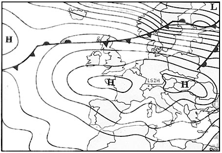
Lszh.
Essa enfb efhk
Question 165-22 : Flight lisbon to bordeaux eta 1800 utc what type of precipitation is forecast on the approach to bordeaux taf lfbd 281400z 281524 26015kt 9999 shra bkn020 tempo 1620 26020g30kt 8000 +shra bkn015cb prob30 tsra = ?
Heavy rain showers.
Continuous moderate rain. light drizzle and fog. moderate snow showers.
Question 165-23 : An airborne weather radar installation makes it possible to detect the location of ?
Zones of precipitation particularly liquid state precipitation and also their intensity.
All clouds cumulonimbus, but provided that cloud of this type is accompanied by falls of hail stratocumulus and its vertical development
Question 165-24 : At which altitude at temperate latitudes may hail be expected in connection with a cb ?
From the ground up to a maximum of fl 450.
From the ground up to about fl 200. from the ground up to about fl 100. from the base of the clouds up to about fl 200.
Question 165-25 : With which of the following types of cloud is '+ra' precipitation most commonly associated ?
Ns.
Ac. sc. st.
Question 165-26 : With what type of cloud is 'gr' precipitation most commonly associated ?
Cb.
St. cc. as.
Question 165-27 : With what type of cloud is 'dz' precipitation most commonly associated ?
St.
Drizzle is a slowly falling precipitation in the form of tiny water droplets with diameters less than 05 millimeters it falls from stratus clouds and is often associated with low visibility and fog stratus does not usually produce precipitation but when it does occur it is in the form of minute particles such as drizzle ice crystals or snow grainsCb. cc. cu.
Question 165-28 : Which of the following cloud types is least likely to produce precipitation ?
Ci.
Cb. as. ns.
Question 165-29 : With what type of cloud is heavy precipitation unlikely during the summer months ?
Sc as.
Cb cumulonimbus and ns nimbostratus produce heavy rainthe only possible answer is sc as stratocumulus and altostratus with sc and as you will get light rainsCb, st. ns, cc. as, ns.
Question 165-30 : With what type of cloud is '+tsra' precipitation most commonly associated ?
Cb.
As. sc. ns.
Question 165-31 : Which of the following causes echoes on meteorological radar screens ?
Hail.
Water vapour. fog. any cloud.
Question 165-32 : Which of the following phenomena should be described as precipitation at the time they are observed ?
Sn.
Only sn snow is a precipitationhz hazebcfg fog patchesfzfg freezing fogBcfg. hz fzfg.
Question 165-33 : Which of the following meteorological phenomena can rapidly change the braking action of a runway ?
+fzra.
Mifg fg hz
Question 165-34 : Which of the following phenomena can produce a risk of aquaplaning ?
+ra.
Only ra rain is a precipitation which produce a risk of aquaplaning '+ra' means 'heavy rain' fg fogbcfg fog patchessa sandFg bcfg sa
Question 165-35 : Which of these four metar reports suggests that rain is most likely in the next few hours ?
23015kt 8000 bkn030 ovc070 1714 q1009 becmg 4000 = cloud base is low visibility will reduced and temperature and dew point are close we have a high relative humidity rain can occur 16002kt 0100 fg sct300 0606 q1022 becmg 1000 = wind 2kt no clouds fog it will not lead rain 05016g33kt 8000 ovc015 0806 q1028 nosig = too much wind visibility remains good 34004kt 9999 sct040 sct100 m05m08 q1014 nosig = too cold not enough clouds good visibility and no wind16002kt 0100 fg sct300 06/06 q1022 becmg 1000 = 05016g33kt 8000 ovc015 08/06 q1028 nosig = 34004kt 9999 sct040 sct100 m05/m08 q1014 nosig =
Question 165-36 : Precipitation in the form of showers occurs from ?
Convective clouds.
Stratified clouds cirro-type clouds clouds containing only ice crystals
Question 165-37 : A super cooled droplet is ?
A droplet still in liquid state at a temperature below 0°c.
A water droplet that is mainly frozen. a small particle of water at a temperature below -50°c. a water droplet that has been frozen during its descent.
Question 165-38 : Steady precipitation in contrast to showery precipitation falls from ?
Stratiform clouds with little or no turbulence.
Convective clouds with little or no turbulence stratiform clouds with severe turbulence convective clouds with moderate turbulence
Question 165-39 : Supercooled droplets can occur in ?
Clouds fog and precipitation.
Clouds but not in precipitation precipitation but not in clouds clouds but not in fog
Question 165-40 : Supercooled droplets are always ?
At a temperature below freezing.
Small and at a temperature below freezing large and at a temperature below freezing at a temperature below -60°c
Exclusive rights reserved. Reproduction prohibited under penalty of prosecution.