A free Premium account on the FCL.055 website! Read here
Sign up to unlock all our services and 15164 corrected and explained questions.
Question 166-1 : The following statements deal with precipitation turbulence and icing select the list containing the most likely alternatives for ns cloud ? [ Formation assignment ]
Precipitation may be snow sleet or rain icing is probable and may range between light and severe turbulence is rarely more than moderate
Question 166-2 : From what type of cloud does drizzle fall ?
Stratus.
Stratus does not usually produce precipitation but when it does occur it is in the form of minute particles such as drizzle ice crystals or snow grainsAltostratus cumulus cirrostratus.
Question 166-3 : What type of clouds are associated with rain showers ?
Towering cumulus and cumulonimbus.
Shower rainsnow towering cumulus cumulus and cumulonimbuscontinuous rainsnow nimbostratusshower rain short duration rainTowering cumulus and altostratus. altostratus and stratus. nimbostratus.
Question 166-4 : What type of clouds are associated with snow showers ?
Cumulus and cumulonimbus.
Shower rainsnow towering cumulus cumulus and cumulonimbuscontinuous rainsnow nimbostratusshower rain short duration rainCumulus and altostratus. altostratus and stratus. nimbostratus.
Question 166-5 : Which of the following phenomena should be described as precipitation at the time they are observed ?
Dz.
Sa ts sq
Question 166-6 : Which of the following phenomena should be described as precipitation at the time they are observed ?
Shsn.
Shsn snow showerva volcanic ashbr mistmifg shallow fogVa mifg br
Question 166-7 : Solid precipitation which is transparent or translucent and has a diameter of 5mm or less formed by the freezing of raindrops or refreezing of melted snow and usually bounces off hard surfaces is a description of ?
Ice pellets.
Hail. snow grains. small hail.
Question 166-8 : During flight in clouds which of the following means is the best one to identify the position of embedded cbs ?
Weather radar.
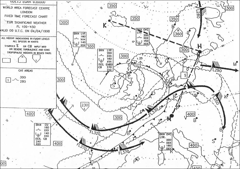
Significant weather chart. aircraft observations. the pilot requests the position of the cbs from the atc controller.
Question 166-9 : Which of the following statements concerning airborne weather radar is correct ?
It shows on a plan position indicator the areas of precipitation of rain snow andor hail.
Cqb15 august 2011It can also be used for proximity warning and anti-collision protection. the indication on the plan position indicator represents the amount (mm/h) of water vapour within clouds. it shows the areas which are dangerous for aircraft icing. the intensity levels for aircraft icing as defined by icao are indicated by contour lines.
Question 166-10 : Snow grains ?
Fall from stratus or supercooled fog.
Stratus does not usually produce precipitation but when it does occur it is in the form of minute particles such as drizzle ice crystals or snow grainsAre normally transparent. are mainly formed inside altostratus and nimbostratus. are typically formed inside a cb, where they are being tossed up and down while growing to such size that they could no longer be supported in the updraught.
Question 166-11 : Which of the following statements is true concerning the bergeron findeisen process ?
It only takes place in clouds with supercooled water droplets and ice crystals.
The bergeron findeisen process can be summarized as such the air reaches saturation and some of the resulting droplets will come in contact with freezing nuclei assuming they have reached the activation temperature we will now have a combination of ice crystals and supercooled water droplets from the perspective of the supercooled droplets the air is in equilibrium at saturation but from the perspective of the ice crystals the air is supersaturated therefore water vapor will sublimate on the ice crystals since the amount of water vapor in the air has decreased and from the perspective of the supercooled water droplet the air is subsaturated the supercooled water will evaporate until the air once again reaches saturation the process then continues in short summary the ice crystal grows through sublimation at the expense of the supercooled water dropletIt only occurs in the mid-latitudes. it takes place in clouds which are composed only of ice crystals. it does not occur in the tropics.
Question 166-12 : Which of the following statements is true concerning the coalescence process ?
In the mid latitudes this process produces only drizzle or very light rain.
Cloud droplets are carried by air currents within the cloud if they bump into each other it is called a collision however if they collide then stick together that is called coalescencethis process is important especially in the tropics and in increasing the size of raindrops it falls short of being the primary mechanism for the formation of raindropsthe collision coalescence process is of relatively little importance in middle and high latitudes where even in the summer precipitation begins high in the clouds where temperatures are well below freezing and the dominant precipitation producing mechanism is the so called ice crystal or bergeron processIt only occurs in the tropics. it only takes place in convective clouds. it only occurs in the mid-latitudes.
Question 166-13 : The processes andor effects which cause clouds to release precipitation are ?
Coalescence process and bergeron findeisen process.
Quick overview of precipitation formation processes click here to open the video in a new windowBergeron-findeisen process and convection effect. convection effect and advection effect. advection effect and coalescence process.
Question 166-14 : State the code used to indicate moderate precipitation in the form of snow flakes from a cumulonimbus cloud ?
Shsn.
Ecqb03 july 2016Sn +so ra+
Question 166-15 : The size of a drizzle droplet ?
Less than 05 mm.
Ecqb03 july 2016drizzle is a slowly falling precipitation in the form of tiny water droplets with diameters less than 05 millimeters it falls from stratus clouds and is often associated with low visibility and fog stratus does not usually produce precipitation but when it does occur it is in the form of minute particles such as drizzle ice crystals or snow grainsLess than 0.5 cm. equal or more than 0.5 mm. equal or more than 0.5 cm.
Question 166-16 : The presence of ice pellets at a height of 8000 ft indicates ?
Freezing rain at heights above 8000 ft.
Ecqb03 july 2016Freezing rain at heights below 8000 ft. snow at heights above 8000 ft. hail at heights below 8000 ft.
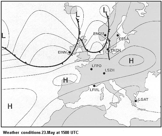
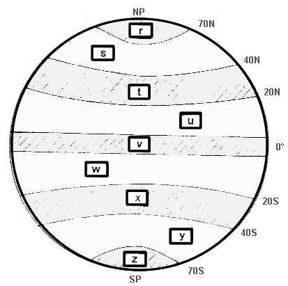
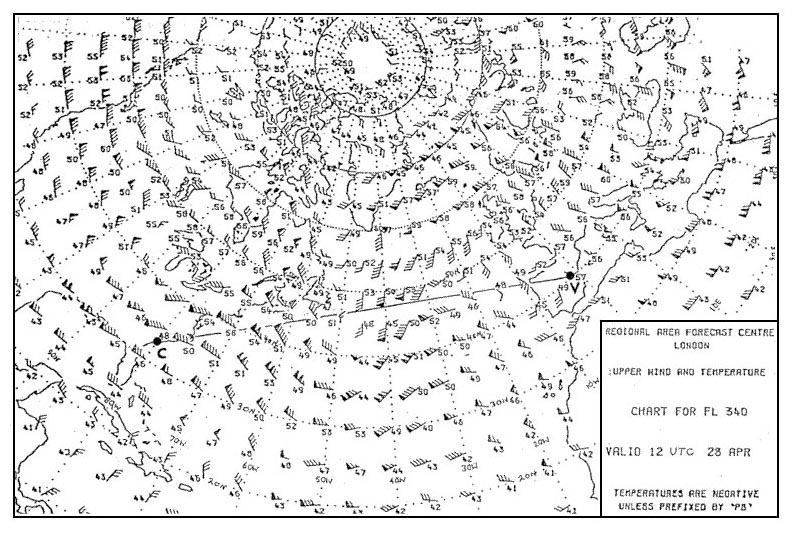
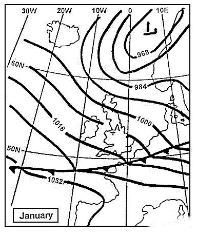
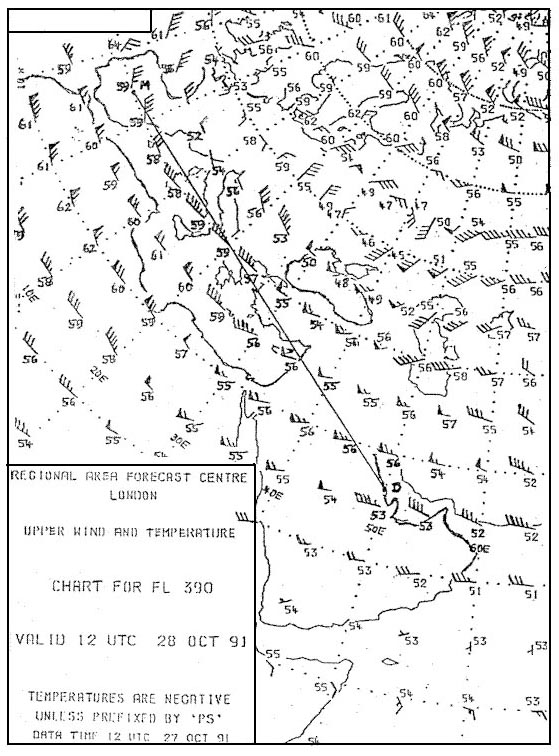
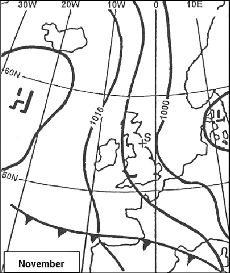
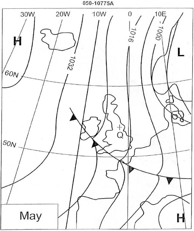
Question 166-17 : The weather most likely to be experienced at position 'q' is 414 ?
Showery with generally good visibility.
Mainly clear skies with fog developing overnight. mainly overcast skies with poor visibility. thundery showers particularly at night.
Question 166-18 : Which statement best describes coalescence ?
Droplets velocity increases with their radius those who have grown faster will fall faster than others and will sweep smaller droplets.
Droplets velocity changes with their radius, smallest droplets will fall faster than others. its the process in which a material changes from a frozen solid to a gas without passing through the intermediate liquid state. its the process by which water vapor in the air is changed into liquid water.
Question 166-19 : Which of the following is typical for the passage of an active cold front in the summer ?
Mainly towering clouds.
An active cold front is pushing warm moist air up from underneath producing some layered cloud but almost always cumulus cloud and turbulent weather 639when the front has passed through the air is now cold and therefore more dense and dense air is higher pressureMainly layered clouds. rapid drop in pressure once the front has passed. rapid increase in temperature once the front has passed.
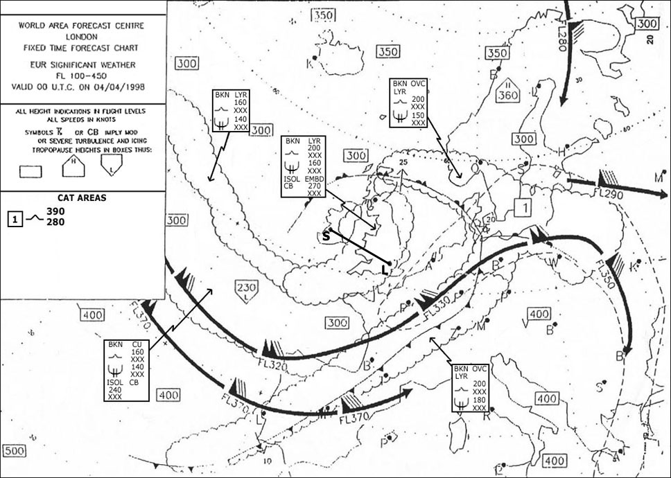
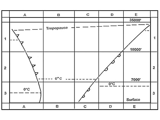
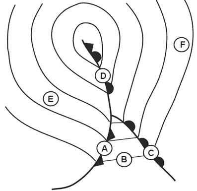
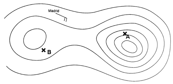
Question 166-20 : Examining the pictures on which one of the tracks dashed lines is this cross section to be expected 250 ?
Track b d.
Only one dashed line crosses two fronts a cold front and a warm front Track b-c. track a-d. track a-e.
Question 166-21 : Frontal depressions can be assumed to move in the direction of the 2000 feet wind ?
In the warm sector.
508the isobars in the warm sector tend to be parallel and straight and give an indication in the direction of the system until it occludesisobars indicate the direction of the wind at least at 2000 ft above the surface the free stream unaffected by surface friction In front of the warm front. behind the cold front. at the apex of the wave.
Question 166-22 : What types of cloud will you meet flying towards a warm front ?
At some 800 km cs later as and at some 300 km ns until the front.
505when approaching an active warm front at medium to low level you can expect a low cloud base poor visibility and rainExtensive areas of fog. at some 100 km from the front ns begin. at some 500 km as, later cs and at some 80 km before the front cb. at some 500 km from the front, groups of cb, later at some 250 km thickening as.
Question 166-23 : The polar front is ?
The boundary between polar and tropical air masses.
The polar front is the boundary between polar air and tropical air 595The boundary between arctic and tropical air masses. the boundary between arctic and polar air masses. the constant frontal activity situated at about 80 degrees north and south.
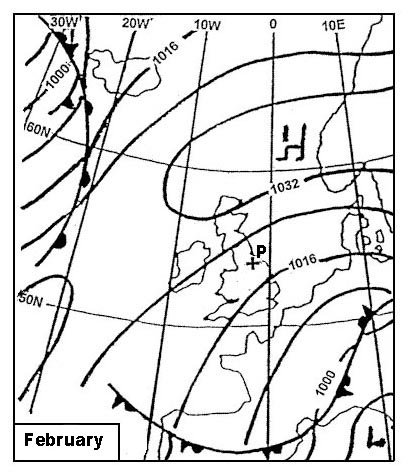
Question 166-24 : What are the typical differences with regard to the temperature and humidity between an air mass with its origin in the azores and an air mass with its origin over northern russia ?
The air of the azores is warmer and more humid than the north russian air.
The north-russian air is colder and more humid than the air of the azores. the air of the azores is warmer and dryer than the north-russian air. the north-russian air is warmer and dryer than the air of the azores.
Question 166-25 : Where is the source of continental tropical air that affects europe in summer ?
The southern balkan region and the near east.
Southern italy. southern france. the azores region.
Question 166-26 : Where does polar continental air originate ?
Siberian landmass.
Polar ice cap. the region of the azores. the region of the british isles.
Question 166-27 : What type of fronts are most likely to be present during the winter in central europe when temperatures close to the ground are below 0°c and freezing rain starts to fall ?
Warm fronts warm occlusions.
Freezing rain is associated with warm fronts and warm occlusions in a warm front the freezing level is lower than behind in the warm sector and the slope means that freezing rain will be falling on anything underneath so if you are flying towards a warm front or warm occlusion watch out supercooled water droplets from above will freeze onto your cold airframe once you see ice pellets expect freezing rain next 505Cold occlusions. high level cold fronts. cold fronts.
Question 166-28 : Which of the following conditions are you most likely to encounter when approaching an active warm front at medium to low level ?
Low cloud base and poor visibility.
505when approaching an active warm front at medium to low level you can expect a low cloud base poor visibility and rainSevere thunderstorms at low altitude. extreme turbulence and severe lightning striking the ground. high cloud base, good surface visibility, and isolated thunderstorms.
Question 166-29 : During a cross country flight at fl 50 you observe the following sequence of clouds nimbostratus altostratus cirrostratus cirrus which of the following are you most likely to encounter ?
Decreasing temperatures.
The cloud types described will be found in a warm front 506you are flying from the warm sector through the warm front in direction of the cold sector the outside temperature will be decreasingA strong downdraught. increasing temperatures. strong, gusty winds.
Question 166-30 : What cloud formation is most likely to occur at low levels when a warm air mass overrides a cold air mass ?
Nimbostratus.
a warm air mass overrides a cold air mass this is a warm front 505at low levels you will have stratus and nimbostratusCumulus. altostratus. cumulonimbus.
Question 166-31 : The approximate inclined plane of a warm front is ?
Is 1150.
628the slope of a warm front 1150 is lower than the one of the cold front 150Is 1/50. is 1/300. is 1/500.
Question 166-32 : What type of low pressure area is associated with a surface front ?
Polar front low.
An area of low pressure found together with a surface front is a 'frontal depression'frontal depressions are mid latitude weather systems formed due to differences in temperature and pressure of adjacent or converging air masses those frontal depression born on the front between polar and temperate air masses create a warm front where the warmer air rises over the colder one then trail a cold front behind itA cold air pool. a low on lee side of a mountain. heat low.
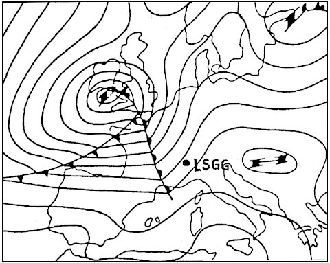
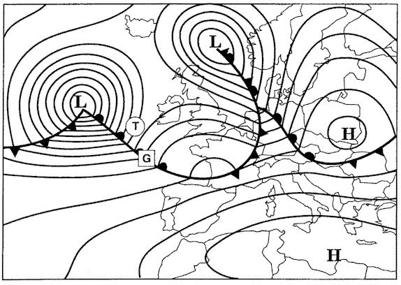
Question 166-33 : In which approximate direction does the centre of a non occluded frontal depression move ?
In the direction of the warm sector isobars.
A question uses the following annex and asks where will move the frontal depression 507answer is n°3 508the isobars in the warm sector tend to be parallel and straight and give an indication in the direction of the system until it occludesIn the direction of the isobars ahead of the warm front. in the direction of the sharpest pressure increase. in the direction of the isobars behind the cold front.
Question 166-34 : Where is the coldest air to be found in an occlusion with cold front characteristics ?
Behind the front.
Ahead of the front. at the surface position of the front. at the junction of the occlusion.
Question 166-35 : What type of front occlusion usually moves the fastest ?
Cold front.
621Warm front. cold occlusion. warm occlusion.
Question 166-36 : What weather conditions are prevalent during the summer over the north sea approximately 300 km behind a quickly moving cold front ?
Cloud cover mostly scattered isolated showers.
Advection fog. rain covering a large area, 8 octas ns. 8 octas cs, as without precipitation.
Question 166-37 : What is the surface visibility most likely to be in a warm sector of maritime tropical air during a summer afternoon in western europe ?
Moderate several km .
The warm sector is invariably tropical maritime air mass warm moist and stable visibility is generally not good but on a warm summer afternoon the air becomes less stable the relative humidity decreases and visibility improvesVery poor (less than 1 km). good (greater than 10 km). very good (greater than 50 km).
Question 166-38 : After passing at right angles through a very active cold front in the direction towards the cold air what will you encounter at fl 50 in the northern hemisphere immediately after a marked change in temperature ?
A veering in the wind direction.
In the northern hemisphere the air flows anti clockwise around a depression 509if you are flying through the cold front from the warm sector to the cold sector at right angles the wind which was previously from the left of your nose becomes from the right of your nose that means the wind direction has increased in heading so that is veeringA backing in the wind direction. an increase in tailwind. a decrease in tailwind.
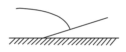
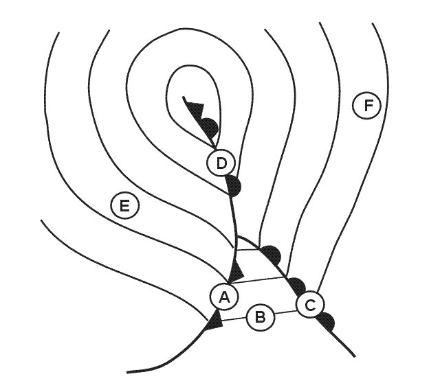
Question 166-39 : Which one of the tracks dashed lines is represented by the cross section shown on the left 258 ?
Track d a.
Track d a corresponds to a warm occlusion 628with a warm occlusion cold front rides up and over the warm frontif the line of the occlusion is approximately along the same line as the warm front then we have a warm occlusion 512Track c-a track b-a track b-c
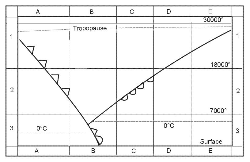
Question 166-40 : Which cross section of air mass and cloud presentation is applicable to the straight line a b 259 ?
N°3.
N°1 cold front and n°4 warm front are out line a b is an occlusionn°3 is a warm occlusion and n°2 a cold occlusioncold front rides up and over the warm front 512if the line of the occlusion was approximately along the same line as the warm front then we have a warm occlusion n°3 N°1 n°2 n°4
Exclusive rights reserved. Reproduction prohibited under penalty of prosecution.