A free Premium account on the FCL.055 website! Read here
Sign up to unlock all our services and 15164 corrected and explained questions.
Question 168-1 : An unstable air mass will normally be characterised by ? [ Formation assignment ]
Cumuliform cloud and good visibility except in precipitation
Question 168-2 : Cold air pools ?
Are most evident in the temperature and wind fields of the upper levels.
A cold pool is a meteorologic term for a cold air block it is an area with light or no wind low temperature it is a place of instability and convective activitya cold air pool can be best identified by means of the isohypses on an upper air chartisohypses contour lines are drawn on a constant pressure chart therefore they indicate the true altitude of a pressure level on an upper air chart as it includes temperature and wind indications you can easily identify a cold air pool you will have an area with light or no wind low temperature Can easily be recognized on synoptic surface charts. only occur at mid-latitudes. only occur in winter.
Question 168-3 : Considering the north atlantic between 30°n and 65°n the mean position of the polar front during winter extends from ?
Florida to sw england.
From summer to winter the polar front over the north atlantic moves towards the south 585between 30°n and 65°n in winter low pressure systems centered over iceland greenland high pressure systems centered over azores siberia the polar front extends from florida to sw englandbetween 30°n and 65°n in summer low pressure systems centered over ne canada high pressure systems centered over azores se usa sw europe the polar front extends from newfoundland to n scotlandNewfoundland to iceland. iceland to norway. ne canada to portugal.
Question 168-4 : Considering the north atlantic region between 30°n and 65°n the mean position of the polar front during summer extends from ?
Newfoundland to n scotland.
From winter to summer the polar front over the north atlantic moves towards the north 598between 30°n and 65°n in winter low pressure systems centered over iceland greenland high pressure systems centered over azores siberia the polar front extends from florida to sw englandbetween 30°n and 65°n in summer low pressure systems centered over ne canada high pressure systems centered over azores se usa sw europe the polar front extends from newfoundland to n scotlandFlorida to sw england. ne canada to iceland. greenland to spain.
Question 168-5 : For an airfield located in the british isles the passage of a warm front will usually be indicated by ?
Rise in temperature rise in dew point temperature wind veers and decreases.
567ahead of a warm front in northern hemisphere as ahead of a cold front the wind veers in the friction layer and veers above the friction layeron the passage of a warm front the temperature and dew point will rise the wind will veer and decrease there will not be a rapid improvement in visibility or a rapid fall in pressureA fall in temperature, rise in dew point temperature, wind backing and decreasing. rapid improvement in visibility, pressure falling rapidly, wind veering and increasing. rise in temperature, rapid rise in pressure, wind backs and becomes gusty.
Question 168-6 : In the weather pattern behind a cold front the visibility outside precipitation is ?
Good and the precipitation is showers.
614in the weather pattern behind a cold front the visibility outside precipitation is good and the precipitation is showersGood and the precipitation is steady rain. low and the precipitation is showers. low and the precipitation is steady rain.
Question 168-7 : The passage of a warm front can be associated with areas of fog the types of fog just in advance and just after the passage are respectively ?
Frontal fog and advection fog.
Radiation fog forms due to surface cooling at night in a light windsteaming fog is the same as arctic smoke or sea smoke and is caused by cold air moving over a warm surfaceadvection fog forms when warm humid air flows over a cold surfacefrontal fog is most likely to occur in advance of a warm front it is due to the rain falls from the warm air into the cold airAdvection fog and radiation fog. arctic smoke and frontal fog. advection fog and steaming fog.
Question 168-8 : The pressure system indicated when in a vertical cross section the lower situated pressure surfaces bulge upward and the higher situated pressure surfaces bulge downward is a ?
Cold high pressure area.
You have a high pressure at the surface and low temperatures in the air 604Cold low pressure area. warm low pressure area. warm high pressure area.
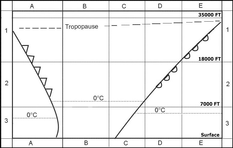
Question 168-9 : The lowest cloud type observed is stratus fractus and there is moderate continuous rain the area of the system in which you are at this moment is ?
The main body of the warm or cold front or of the occlusion.
622 605Behind the cold front. the warm sector. the high pressure area.
Question 168-10 : What is signified if an occlusion is described as 'cold' ?
The air ahead of the associated warm front is less cold than the air behind the associated cold front.
537cold front 'lifts' the warm front up and over the very cold airIt derives from a polar depression. the air ahead of the associated warm front is colder than the air behind the associated cold front. on meeting the warm front, the cold front moves up the warm frontal surface.
Question 168-11 : When a front has to cross a chain of mountains its activity ?
Strengthens 'upwind' of the mountains.
Decreases when it reaches the mountains. is not disturbed by the mountains. ceases immediately.
Question 168-12 : When flying at 5000 ft in the northern hemisphere over plains with an anticyclone on the left and a depression on the right the wind will be ?
A head wind.
If you stand with your back to the wind in the northern hemisphere low pressure is on your left buys ballot's law 606it means that an anticyclone is on your right and a depression is on your leftbut if you turn yourself to have the anticyclone on your left and the depression on your right the wind will be a head wind 607From the left. from the right. a tail wind.
Question 168-13 : What type of weather can usually be expected in a polar maritime air mass over central europe in the daytime during summer ?
Showers and good visibility.
A polar maritime air mass originates over the northern part of the north atlantic ocean it is unstable cool and moist air and can produce anything from cumulus to cumulonimbus with showers and sunny spells in between 611Continuous rain and poor visibility. drizzle and low stratus. sky clear.
Question 168-14 : Which statement is correct for a warm occlusion ?
The cold front becomes a front aloft.
628with a warm occlusion the warmer of the cold air masses is doing the pushing from the back so it cannot 'burrow' under the colder air ahead and so it 'slides' up the warm front surfaceThe warm front overtakes the cold front. the warm front becomes a front aloft. both fronts become fronts aloft.
Question 168-15 : The air mass in the warm sector of a polar front is ?
Tropical air.
The polar front is the boundary between polar air and tropical air 481warm sector is tropical air massair behind the polar front is cold this is the polar air massPolar air. arctic air. equatorial air.
Question 168-16 : Which two air masses are most likely to govern weather in western europe ?
Maritime tropical warm and maritime polar cold.
Continental tropical warm and continental polar cold. maritime tropical warm and continental polar cold. maritime polar warm and continental tropical warm.
Question 168-17 : The air masses that are observed most frequently over western europe are ?
Polar air and tropical air.
Arctic air and polar air. polar air and equatorial air. arctic air and tropical air.
Question 168-18 : Which type of air mass never occurs over central europe ?
Equatorial air.
Arctic air. polar air. tropical air.
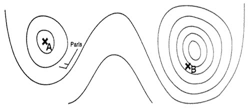
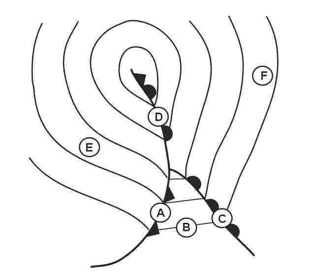
Question 168-19 : The weather most likely to be experienced at position 'b' is 327 ?
Frequent showers of rain or snow.
A cold front has passed over position 'b' few hours ago we are in the cold sector behind the cold front 614in the weather pattern behind a cold front the visibility outside precipitation is good and the precipitation is showers in march rain or snow Advection fog and drizzle. poor visibility in anticyclonic circulation. early morning fog lifting to low stratus later.
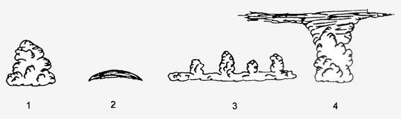
Question 168-20 : During summer the cloud type most applicable to square 2a is 328 ?
Cb.
Ac st cs
Question 168-21 : The cloud type most applicable to square 2b is 332 ?
Cb.
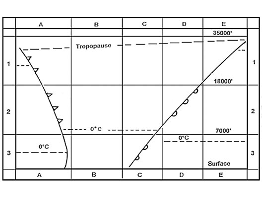
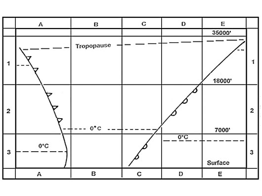
Square 2b is from fl70 to fl180 in this square you can not find any cirrostratus cs high level or stratus and stratoscumulus st and sc low level it remains cb and the cb would be just ahead of the cold frontthe magic drawing 622each question asking for weather in square 2b have four different possible answersin square 2b you can be in the cb or above the stratus in square 3b in clear and stable conditionsyou will not have a question with the two answers availableCs. st. sc.
Question 168-22 : The cloud type most applicable to square 2c is 332 ?
As.
Cs cb cu
Question 168-23 : The cloud type most applicable to square 1e is 332 ?
Cs.
Cb. ns. sc.
Question 168-24 : The front at the bottom of the diagram south of position c is 333 ?
An occlusion on the surface.
613A warm front. an occlusion above the surface. a cold front.
Question 168-25 : The weather most likely to be experienced at position 'b' is 334 ?
Frequent showers of rain or snow good visibility outside showers.
A cold front has passed over position 'b' few hours ago we are in the cold sector behind the cold front 614in the weather pattern behind a cold front the visibility outside precipitation is good and the precipitation is showersScattered stratocumulus with good visibility mainly overcast with stratus or stratocumulus, drizzle clear skies, moderate wind, good visibility
Question 168-26 : The air mass at position 'x' is most likely to be 335 ?
Maritime tropical.
Regarding the overall mass movement the air mass is coming from the ocean the isobars in the warm sector give an indication in the direction of the system until it occludes 623a large body of air will have the characteristics of its origin the source region particulary with regard to moisture and temperature in that a mass of air can originate from tropical or polar regions be warm or cold or be maritime or polar wet or dry Maritime polar. continental polar. continental tropical.
Question 168-27 : The weather most likely to be experienced near to position 'a' is 336 ?
Frequent showers of rain and snow good visibility outside precipitation.
A cold front has passed over position 'a' few hours ago we are in the cold sector behind the cold front 614in the weather pattern behind a cold front the visibility outside precipitation is good and the precipitation is showersAdvection fog and drizzle. overcast layer cloud - rain later. clear skies - radiation fog at night.
Question 168-28 : For an aircraft making an approach to an airfield located in square 3b away from the vicinity of the fronts the most likely weather conditions in winter are 337 ?
Poor visibility in mist and drizzle.
622in summer we could expect scattered sc and cu with good visibility in winter the cloud base would remain low over the land we gonna have poor visibility in mist and drizzleScattered sc and cu, good visibility. generally overcast, moderate continuous rain and risk of low level wind shear. prolonged periods of heavy rain and hail.
Question 168-29 : For an aircraft making an approach to an airfield located in square 3b the most likely weather conditions are 338 ?
Low cloud mist.
This is the warm sector 622once the warm front passes your location you will notice an increase in temperature and air pressure as the warm sector moves into your location you will notice an increase in the humidity of the airModerate continuous rain. showers of rain and hail. scattered ac base 2000 ft, good visibility.
Question 168-30 : What flight conditions are most likely to be experienced in square 2b by an aircraft at fl 120 337 ?
Vmc above layers of st and sc generally stable conditions.
In the middle of the warm sector we would expect to experience typical tropical maritime conditions low stratus poor visibility and drizzle at the surface but at fl120 without frontal lifting action the aircraft would be in clear stable air and above the cloud layersthe magic drawing 622each question asking for weather in square 2b offer four different possible answersin square 2b you can be in the cb or above the stratus located in square 3b in clear and stable conditionsyou will not have a question with the two answers availableVmc below an overcast of as and cs, generally smooth air. imc in layers of as and isolated cb risk of severe turbulence and icing. imc in ns with risk of light icing.
Question 168-31 : The cloud type most applicable to most of square 3b is 337 ?
Sc.
622square 3b is from surface to fl70 in this square you can not find any cirrostratus cs high level cloud or altostratus as medium level cloud you are in the middle of the warm sector in winter you will have stratus in summer the cloud may lift to give stratoscumulus sc low level cloud Cs. as. ns.
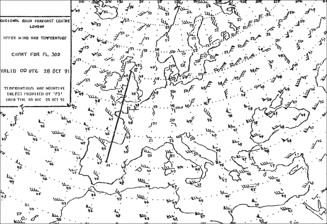
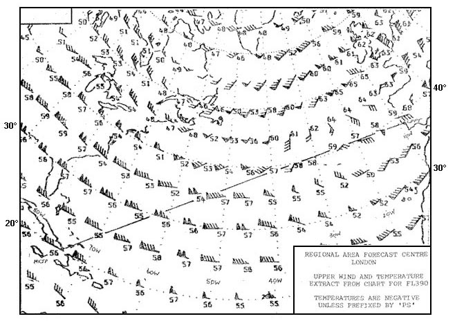
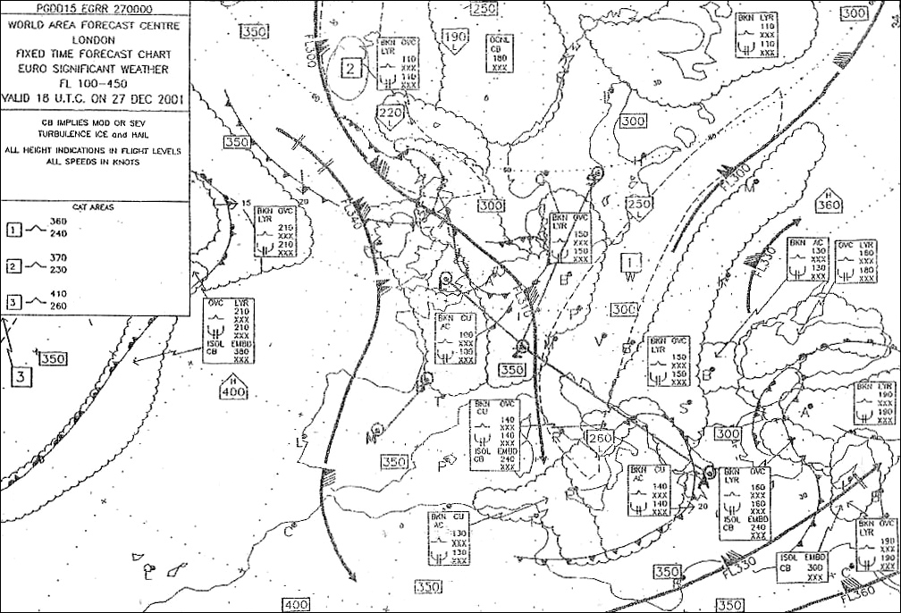
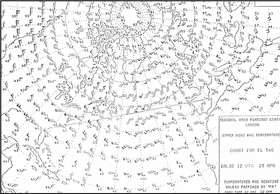
Question 168-32 : For 1300 utc select a metar which you consider to be most appropriate to position 't' 341 ?
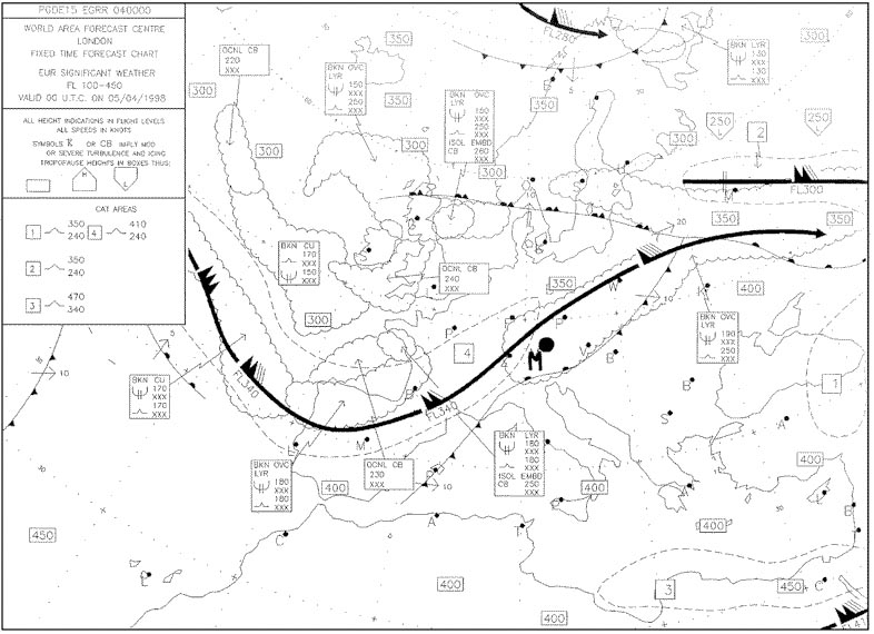
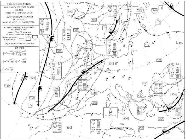
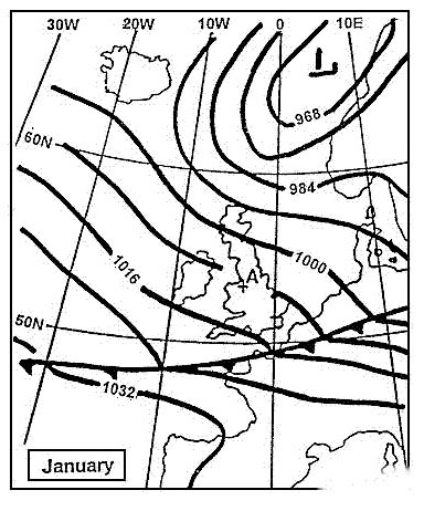
19010kt 6000 ra bkn016 ovc090 0806 q1004=.
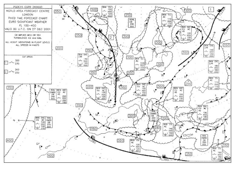
Lasanowc i don't understand why this answeras i can see the wind which blows along the isobars comes approximately from 240the difference between ovc090 and bkn100 is neglibile i think it's a good investigationbut from the isobars the wind comes from 220°in northern hemisphere at mid latitude over land wind speed in friction layer decrease by 50% the wind in the friction layer blows across the isobars towards the low pressure angle between wind direction and isobars changes by 30°220° 30° = 190°there would be low stratus bkn016 and moderate visibility with rain the inclined plane of a warm front is 1150 and the cloud coverage is very compact ovc 615warm front cross section24020kt 5000 ra bkn100 11/10 q1002= 18015kt 9999 sct020 03/01 q1000= 27030kt 8000 sct020 07/03 q1004=
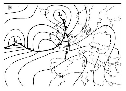
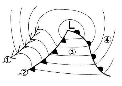
Question 168-33 : The front labelled 'e' is a 343 ?
Cold front.
Warm front. warm occlusion. cold occlusion.
Question 168-34 : The front located from 10°w to 10°e is most likely to be 344 ?
A quasi stationary front.
An active warm front moving north. an active occlusion moving south. a cold front moving south.
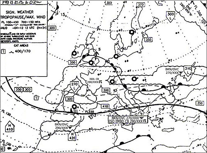
Question 168-35 : From indications shown on the chart when front 's' passes position 'v' the surface wind should 348 ?
Veer and remain more or less at the same speed.
The isobars ahead of and behind the front are parallel and almost straight the surface wind will not change significantly since the isobars remain at the same spacing in the northern hemisphere on the passage of a front the wind will veer change direction clockwise 567Veer and increase. back and remain more or less at the same speed. back and decrease.
Question 168-36 : When front 'g' passes position 't' the surface wind should 350 ?
Veer and increase.
567we know that the wind turns counterclockwise around a low pressure but at position 't' the surface wind veers turn clockwise and increases because the isobars after front g are very close together means stronger wind Veer and decrease back and increase back and decrease
Question 168-37 : What conditions are most likely to prevail at an aerodrome located in square 3b 351 ?
6 8 oktas sc and st visibility moderate to poor in drizzle.
Broken cu base 2000 ft, visibility more than 5 km, occasional showers of rain or snow mainly overcast at 8000 ft, visibility less than 5 km in continuous moderate rain intermittent thunderstorms otherwise generally clear skies with good visibility
Question 168-38 : For an aircraft at fl 80 ahead of the front in square 2d the expected flight conditions are 351 ?
Below as type cloud generally smooth air with light precipitation.
619 622you are below as type cloud there is usually no thunderstorms ahead of a warm front but a possibility of light precipitationthere might be light to moderate turbulence on the front but not ahead of the front the sky is overcastOvercast skies, moderate to heavy turbulence with the possibility of thunderstorms. imc in cumuliform cloud, moderate turbulence with a risk of rime icing. high ci and cs type cloud, light turbulence and poor visibility.
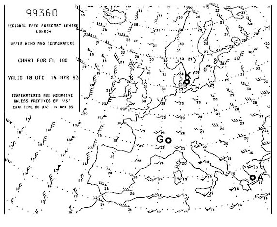
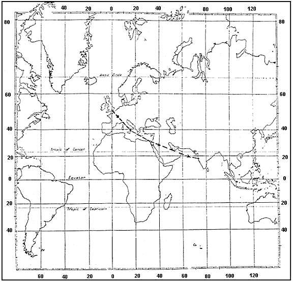
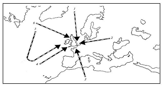
Question 168-39 : The air mass type indicated by arrow number 4 is designated 352 ?
Question 168-40 : The weather most likely to be experienced at position a is 353 ?
Mainly overcast with stratus or stratocumulus and drizzle medium to strong winds.
Position a is located between a warm front and a cold front this is the warm sector 622in summer we could expect scattered sc and cu with good visibility in winter the cloud base would remain low over the land we could expect poor visibility in mist and drizzle stratus andor stratocumulusClear skies, good visibility in light winds cumulus, cumulonimbus clouds, heavy rain or snow showers, medium to strong winds radiation fog, low stratus, drizzle, no medium or upper cloud, light wind
Exclusive rights reserved. Reproduction prohibited under penalty of prosecution.