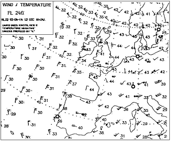
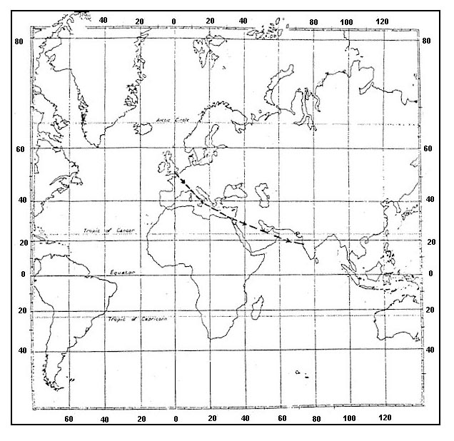
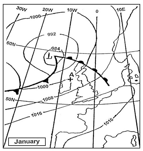
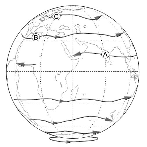
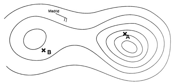
Question 169-4 : The air mass affecting position 'r' is most likely to be 358 ?
Maritime polar.
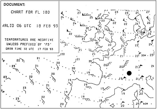
A polar maritime air mass originates over the northern part of the north atlantic ocean it is unstable cool and moist air and can produce anything from cumulus to cumulonimbus with showers and sunny spells in between 623Continental tropical. continental polar. maritime tropical.
Question 169-5 : The air mass affecting position 'c' is most likely to be 359 ?
Maritime tropical.
623a large body of air will have the characteristics of its origin the source region particulary with regard to moisture and temperature in that a mass of air can originate from tropical or polar regions be warm or cold or be maritime or polar wet or dry Continental tropical. maritime polar. continental polar.
Question 169-6 : During the passage of a front in the northern hemisphere the wind veers this statement is ?
True.
567ahead of a warm front in northern hemisphere as ahead of a cold front the wind veers in the friction layer and veers above the friction layerNot true. only true for the passage of a cold front. only true for the passage of a warm front.
Question 169-7 : In the northern hemisphere advection of warm air aloft indicates ?
The approach of a warm occlusion.
With a warm occlusion cold front rides up and over the warm front 626advection = horizontal movementin a warm occlusion the wedge of warm air from a warm sector depression is pushed up by the fast moving cold front and carried along aloft as the depression movesBacking winds with increasing heights. increasing probability for showers. the formation of advection fog.
Question 169-8 : An air mass is ?
An extensive body of air within which the temperature and humidity in horizontal planes are practically uniform.
A large body of air with temperature and humidity constant in the vertical. a body of air with a volume of not more than thousand cubic kilometres. a large body of air within which the temperature and humidity is uniform in horizontal and vertical planes.
Question 169-9 : A stationary front is a front in which ?
There is no horizontal motion perpendicular to the front.
There is no difference in temperature between the two air masses. there is no wind on both sides of the front. there are never frontal clouds.
Question 169-10 : An air mass acquires its basic properties ?
By stagnation of the air for a long period of time over areas having particular characteristics.
By the influence of jet streams by widespread thunderstorms in the westerlies of the mid-latitudes
Question 169-11 : An occlusion is called a warm occlusion when the cold air ?
At the rear of the occlusion is less cold than the cold air ahead with the warm air at a higher altitude.
With a warm occlusion cold front rides up and over the warm front we have cool air behind and cold air ahead 626in a warm occlusion the wedge of warm air from a warm sector depression is pushed up by the fast moving cold front and carried along aloft as the depression movesAhead of the surface position of the occlusion is only at a higher altitude. at the rear of the occlusion is colder than the cold air ahead. at the rear of the occlusion is colder than the cold air ahead, with the warm air at a higher altitude.
Question 169-12 : At a cold front ?
Warm air is lifted as cooler air pushes under it.
621at a cold front the cold air pushes the warm air up warm air is lifted Warm air is compressed as cold air rises over it. temperature rises owing to increased pressure. fog will form from the interaction of cold and warm air.
Question 169-13 : At a station at the surface the significant weather with a warm front will come ?
Mostly before the front passes.
505the question is asking about what happens at the surface onlythe active weather low cloud and continuous rain is ahead of the surface position of the front and the frontal rain stops when the front passes through the surface positionOnly at the same time as the front passes. after the front has passed. after the warm sector has passed.
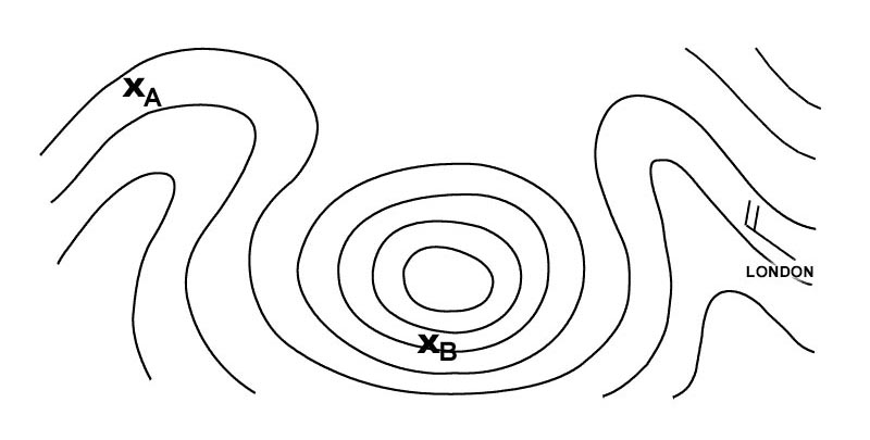
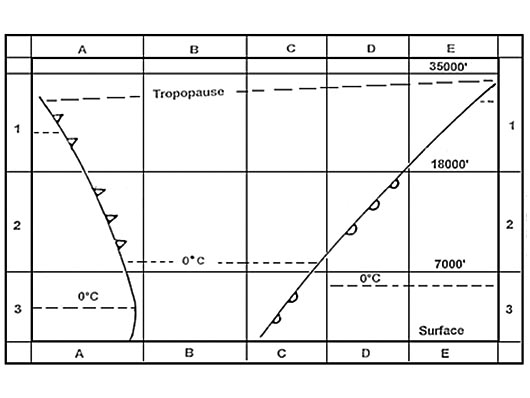
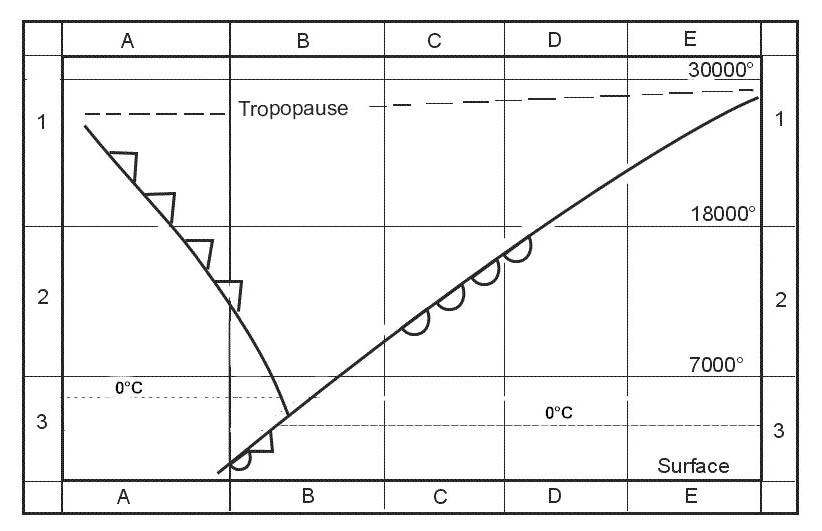
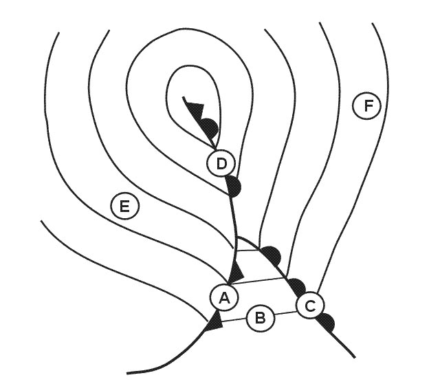
Question 169-14 : The diagram of the system represents a 362 ?
Warm occlusion.
If the warm frontal surface contacts the ground it's a warm occlusion 628Cold occlusion. warm front. cold front.
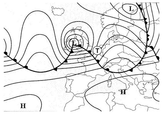
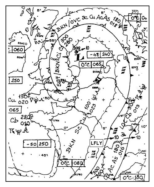
Question 169-15 : The warm sector is indicated by number 364 ?
3.
4. 1. 2.
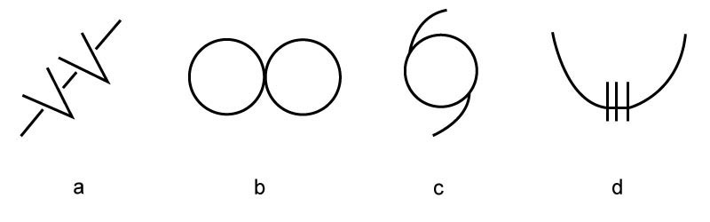
Question 169-16 : A convergence line is indicated by number 364 ?
1.
2. 3. 4.
Question 169-17 : In which air mass are extremely low temperatures encountered ?
Continental polar air.
The lowest temperature is found within the continental polar region because russia where the continental polar region is located is far way from any sea and ocean for this reason it is very cold and dryMaritime polar air. continental tropical air. maritime arctic air.
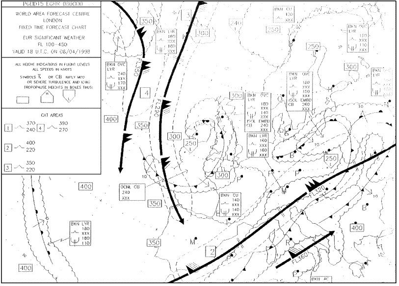
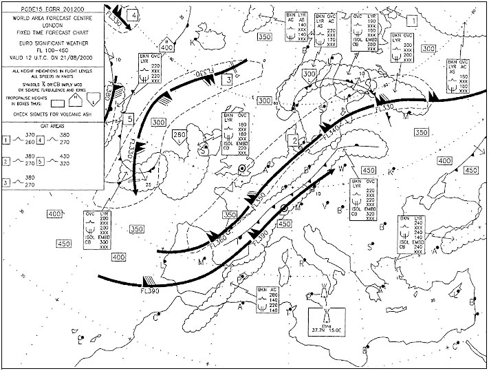
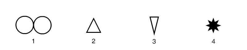
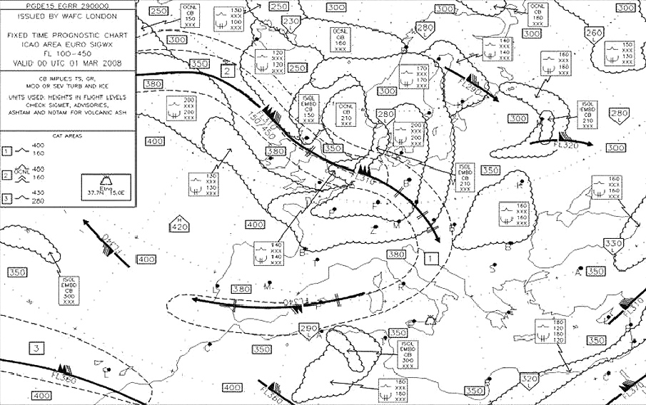
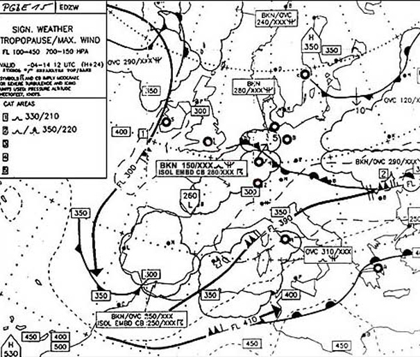
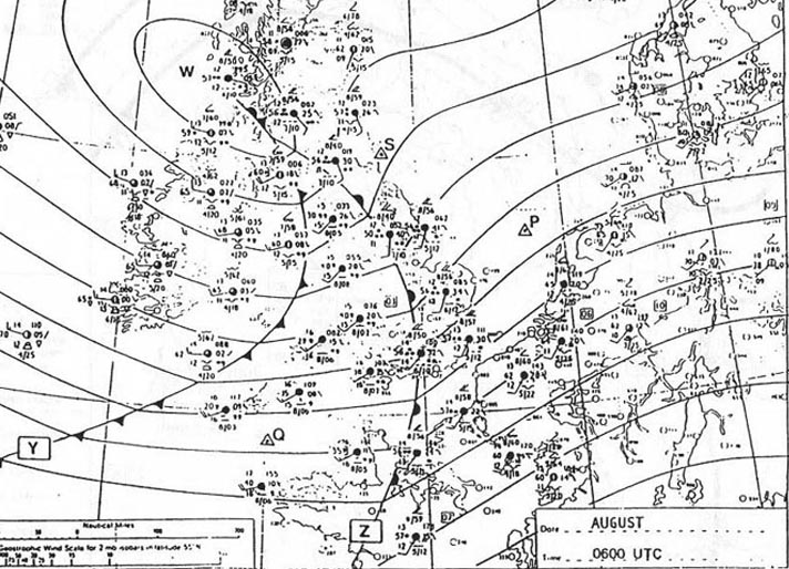
Question 169-18 : At lyon lfly n4545 e00500 at 1200 utc the sky is overcast with stratocumulus and altostratus and it is rainingusing the swc in appendix valid at 1200 utc we can estimate a weather improvement for lyon 369 ?
2100 utc.
A cold front is currently over lfly travelling at 10 kt as indicated by the arrow and '10' we have to wait for the aera behind this front to have a weather improvementit will take between 6h to 10 hours the answer '2100 utc' sounds perfect1330 utc. 0300 utc the following day. 1215 utc.
Question 169-19 : The following sequence of clouds is observed at an airport cirrus cirrostratus altostratus nimbostratus this is typical for ?
The passage of a warm front.
Img505The passage of a cold front. anticyclonic weather. the passage of a squall line.
Question 169-20 : The average slope of a cold front is in the order of ?
Of 1 80.
Of 1:800. of 1:500. of 1:10.
Question 169-21 : The average position of the polar front in the northern hemisphere is ?
More southerly during the winter than during the summer.
The polar front is the boundary between polar air and tropical airduring the winter months in the northern hemisphere the polar front pushes farther southward because of the greater density of the polar air than during the summer monthsin winter the mean position of the polar front extends from florida to sw englandMore southerly during the summer than during the winter. located near 55°n during the whole year. located near 65°n during the whole year.
Question 169-22 : The arctic front is the boundary between ?
Polar air and arctic air.
Polar air and tropical air. cold polar air and less cold polar air. arctic air and tropical air.
Question 169-23 : Which of the following statements is correct ?
Normally atmospheric pressure stops falling rapidly behind a warm front the air temperature rises.
Cumulus clouds and a good visibility are normally observed in a warm sector in autumn. cumulus clouds and a good visibility are normally observed in a warm sector in winter. at warm fronts thunderstorms are often observed.
Question 169-24 : Which statement concerning the cold front and warm front of a frontal depression in the northern hemisphere is correct ?
The risk of fog is greater ahead of and behind the warm front than ahead of and behind the cold front.
Img622ahead of and behind the warm front you have stratocumulus with rain and stratus the risk of fog is greater at the warm frontThe precipitation zone of the cold front is in general wider than the precipitation zone of the warm front. while occluding the warm front always becomes a front aloft. the wind backs more at the warm front than at the cold front.
Question 169-25 : Frontal thunderstorms are mainly associated with ?
Cold fronts.
Cqb15 july 2011Ridges of high pressure. cols. warm fronts.
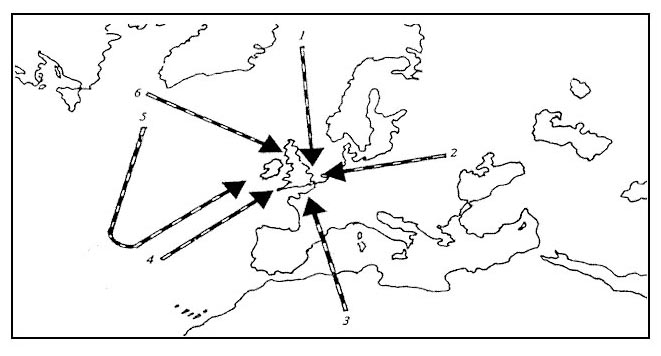
Question 169-26 : An air mass which originates over the north atlantic between 50 and 70 degrees north and is moving in over scandinavia is called ?
Maritime polar air.
Cqb15 august 2011Continental arctic air. maritime arctic air. continental polar air.
Question 169-27 : Which of the following statements is correct concerning the typical weather in a warm sector in mid and high latitudes over continental areas during summer ?
Generally moderate to good visibility haze sometimes few or scattered cumulus.
Cqb15 august 2011Moderate to poor visibility, fog or stratus, stratocumulus and drizzle. generally good visibility outside the frequent showers of cbs. overcast by medium and high clouds, stratus with drizzle, poor visibility.
Question 169-28 : The air mass affecting position 's' is most likely to be 377 ?
Maritime tropical and stable.
623Continental tropical and unstable. maritime polar and stable. maritime polar and unstable.
Question 169-29 : In a westerly situation the mean time interval between polar frontal waves in western europe is ?
One to two days.
Three to four days. six to twelve hours. twelve to eighteen hours.
Question 169-30 : What change in temperature will occur at point a during the next hour 380 ?
A drop in temperature.
A cold front is passing over point a 639the air behind a cold front is noticeably colder and drier than the air ahead of itA rise in temperature. irregular fluctuations. approximately constant temperature.
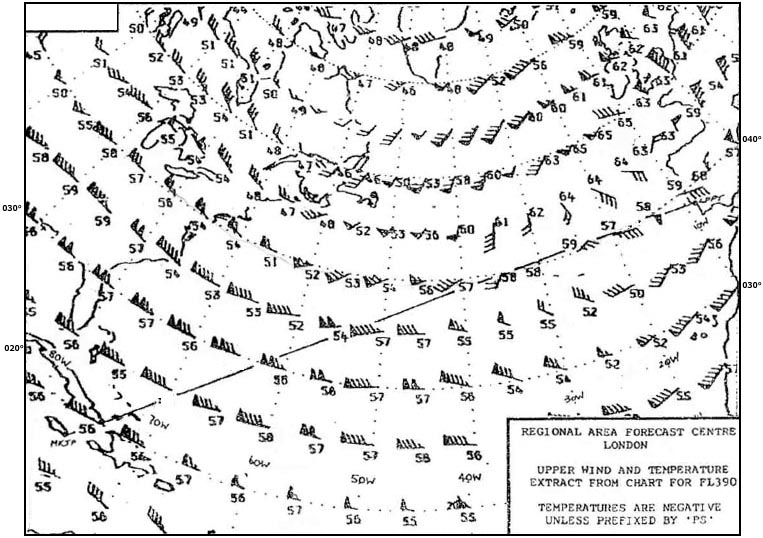
Question 169-31 : The air mass type advected from a direction indicated by arrow number 6 is designated 381 ?
Question 169-32 : What change in pressure will occur at point f during the next hour 382 ?
A drop in pressure.
As the warm front approaches the pressure falls during the passage of the warm sector pressure is steady and after the cold front has passed pressure will riseA rise in pressure. constant pressure. irregular fluctuations.
Question 169-33 : During the winter the air mass type advected from a direction indicated by arrow number 1 is designated 384 ?
Maritime arctic.
Ecair16 what are the difference s between 'maritime polar' and 'maritime arctic' 623polar air masses maritime artic air masses come from the polar cap maritime polar air masses are those which begin their life over cold polar seasMaritime polar. continental arctic. continental polar.
Question 169-34 : Which of the following front types is most known for gusty winds ?
Cold front.
Warm front. occluded front. stationary front.
Question 169-35 : What average geographical latitude is assumed for the zone of the subtropical high ?
30°n.
50°n. 10°n. 0° (equator).
Question 169-36 : Which of these statements about air masses are correct or incorrect 1 the polar ice caps are source regions of polar air2 tropical air may have cold air mass properties ?
1 and 2 are correct.
1 is correct and 2 is incorrect. 1 is incorrect and 2 is correct. 1 and 2 are incorrect.
Question 169-37 : Which of the following is correct regarding a cold high pressure area ?
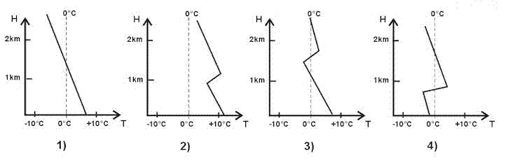
It will decrease in intensity with increasing altitude.
Easa 2014a cold high pressure area is one in which the temperatures on the horizontal plane decrease toward the centerthe pressure deceases rapidly with heightApart from a surface inversion, the temperature will increase with increasing altitude. both temperature and pressure will remain constant with increasing altitude. it will increase in intensity with increasing altitude.
Question 169-38 : What change in temperature will occur at point b during the next hour 391 ?
Approximately constant temperature.
Easa 2014without a scale we can't tell if the cold front will pass through this position during the next hour but the question statement is during the next hour not 'in one hour'spacing of isobars at point b and in front of the cold front are the same therefore the temperature at point b should remain constant during the next hour because the pressure will not changein about one and a half hours we can expect to see a drop in temperature when the cold front will pass above point bA drop in temperature. a rise in temperature. irregular fluctuations.
Question 169-39 : What are the typical weather conditions in a warm anticyclone over land ?
Fine weather dominates in summer.
During summer in the centre of a warm anticyclone over land stationary high pressure zone = flat pressure pattern we have light or no wind 492weather is fine but you can get thunderstorms in the afternoon or evening due to convective activity the land warms causing convective lifting = cb Only short term weather improvements. in the winter ground fog formation is not common. strong westerly winds.
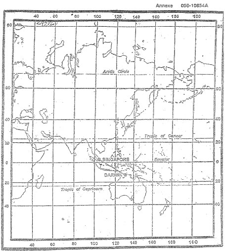
Question 169-40 : For this question use annex 050 061 the weather most likely to be experienced at position 's' is 394 ?
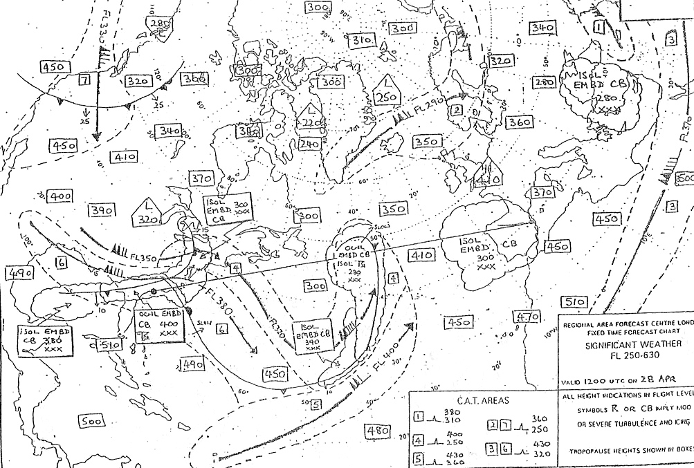
Frequent heavy showers of rain or snow.
Ecqb03 july 2016Ovc bc. morning fog lifting to low stratus. little or no cloud, hazy.
Exclusive rights reserved. Reproduction prohibited under penalty of prosecution.