A free Premium account on the FCL.055 website! Read here
Sign up to unlock all our services and 15164 corrected and explained questions.
Question 170-1 : Regarding thermodynamic stability and ground visibility what are the difference between a warm air mass and a cold air mass in central europe during summer ? [ Practice protocol ]
The cold air mass is unstable and the visibility is better in the warm air mass
Question 170-2 : What change in the height of the cloud base will be observed when flying in vmc from the cold air side towards a warm front ?
The cloud base descends gradually.
Ecqb03 july 2016The cloud base descends abruptly. the cloud base ascends gradually. the cloud base ascends abruptly.
Question 170-3 : What is the average width of the precipitation zone of a cold front ?
50 100 km.
Ecqb03 july 2016500 -1000 km 10 - 30 km 150 - 200 km
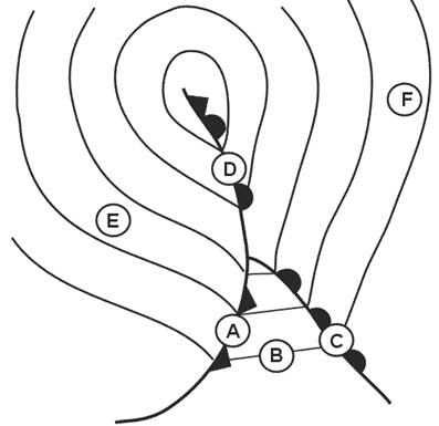
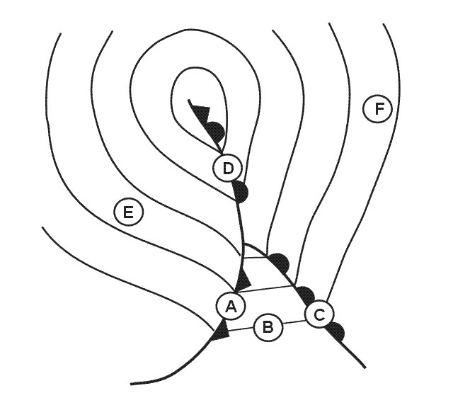
Question 170-4 : Which part of a frontal system corresponds to the following description wind nw gustyclouds cumulus cumulonimbusprecipitation showers occasional thunderstormsvisibility very good apart from precipitation areas ?
Weather behind the cold front.
Ecqb03 july 2016The warm front. the centre of the depression. the cold front.
Question 170-5 : During summer in the centre of a warm anticyclone over land what are cloudiness and visibility like ?
The sky is clear or with few clouds visibility is moderate to poor.
Ecqb03 july 2016The sky is covered with extensive stratus, visibility is very good. the sky is covered with extensive stratus, visibility is moderate to poor. the sky is clear or with few clouds, visibility is very good.
Question 170-6 : The first clouds are thin wispy cirrus followed by sheets of cirrus and cirrostratus and altostratus the sun is obscured as the altostratus thickens and rain begins to fall the cloud base is lowering as nimbostratus arrives these phenomena describe the approach of a ?
Warm front.
Revised ecqb03 july 2016Cold front. sea-breeze front. trade wind front.
Question 170-7 : What average geographical latitude is assumed for the zone of the travelling frontal depressions ?
60°n.
Ecqb03 august 2016an area of low pressure found together with a surface front is a 'frontal depression'frontal depressions are mid latitude weather systems formed due to differences in temperature and pressure of adjacent or converging air masses those frontal depression born on the front between polar and temperate air masses create a warm front where the warmer air rises over the colder one then trail a cold front behind it10°n. 30°n. 80°n.
Question 170-8 : Which meteorological system causes a general collapse of the flight levels and makes dangerous the overflight of mountains ?
A cold air pool cold low .
A warm high. a thermal high. a thermal low.
Question 170-9 : Which thunderstorms generally develop in the afternoon in summer over land in moderate latitudes ?
Airmass thunderstorms.
Occlusion thunderstorms. warm front thunderstorms. cold mass thunderstorms.
Question 170-10 : Strong airmass thunderstorms most often occur during summertime in central europe with the arrival of ?
Maritime tropical air.
Maritime polar air. continental tropical air. continental polar air.
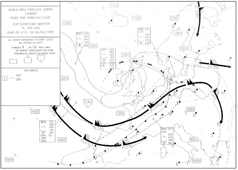
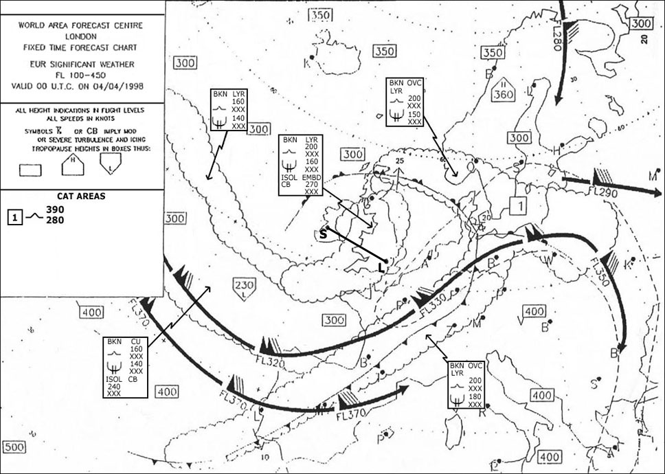
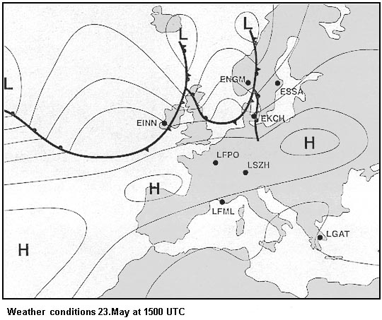
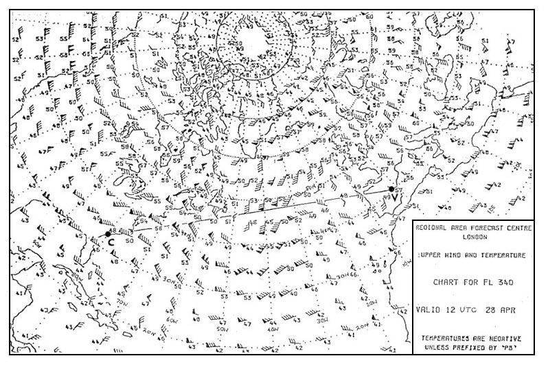
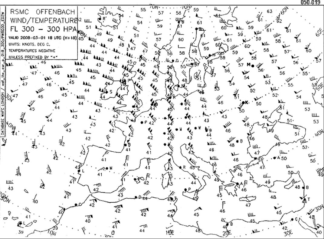
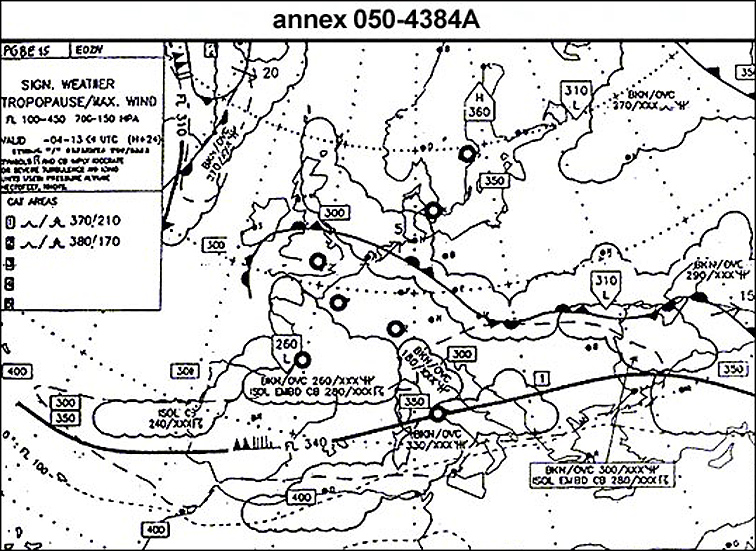
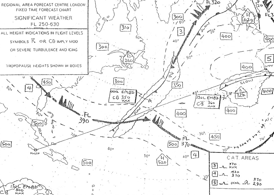
Question 170-11 : Refer to the chart correct statement is 412 ?
The front north of frankfurt is moving north east at about 5 kt.
There is no significant cloud above rome. thunderstorms have formed on the iberian peninsula, with a vertical extension up to around 25000 meters. the jet stream over italy has a maximum speed of 120 km/h.
Question 170-12 : What are the meteorological prerequisites at low level for thunderstorms formed by lifting processes over land ?
High temperatures high humidity.
High air pressure (> 1013 hpa), high temperatures. low temperatures, low humidity. subsidence, inversion.
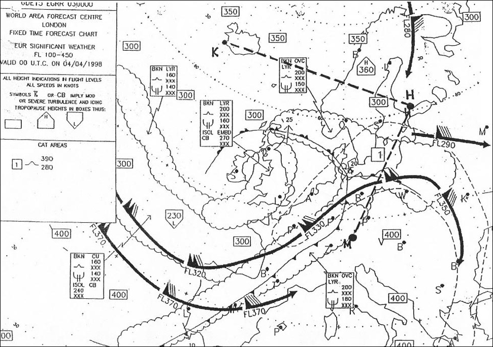
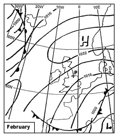
Question 170-13 : The air mass affecting position 'p' is most likely to be 418 ?
Polar continental.
623the wind in northern hemisphere leaves the low pressures on its left from that we deduce a northeasterly windhence a continental polar air massTropical maritime. polar maritime. tropical continental.
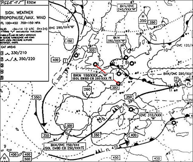
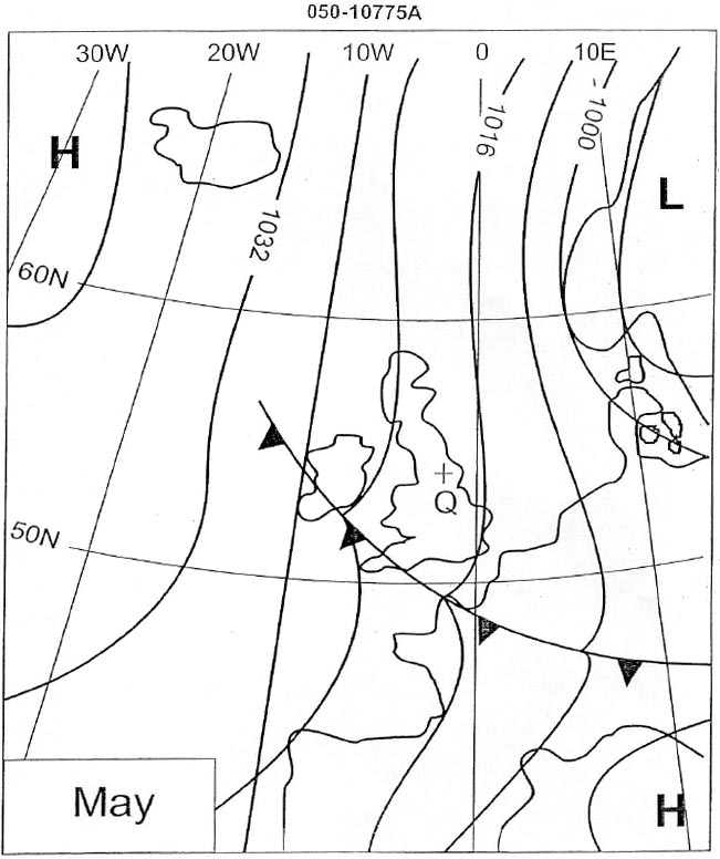
Question 170-14 : Refer to annex 050 10872aby the time the front 'z' has passed point 'q' the surface wind will have 421 ?
Veered and increased.
Ecqb04 january 2018Veered and decreased. turned counterclockwise and increased. turned counterclockwise and decreased.
Question 170-15 : At what time of the year are the paths of north atlantic lows moving from west to east generally at their most southerly position ?
Winter.
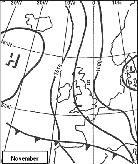
In the winter the north atlantic lows moving from west to east are in their most southerly position having moved from florida to sw englandAutumn. summer. spring.
Question 170-16 : An aircraft is flying in the southern hemisphere at low altitude less than 2000 feet and going directly away from a centre of low pressure what direction relative to the aircraft does the wind come from ?
From the left and slightly on the nose.
497the wind in southern hemisphere rotates clockwise around a low at 2000 ft surface friction will cause the wind to veer and blow across the isobars if you go directly away from the centre the wind comes from the left and slightly on the noseFrom the right and slightly on the nose. from the right and slightly on the tail. from the left and slightly on the tail.
Question 170-17 : Which weather condition lowers true altitude as compared to pressure altitude to a position where flight over mountains could be dangerous ?
Cold low.
When the qnh is lower than 101325 hpa altitude is lower than pressure altitude based on the 101325 hpa datum when the ambient temperature is less than isa the aircraft's true altitude is lower than the indicated altitudethe aircraft could be dangerously lower than its pressure altitude flight level in a cold depressionWarm depression. cold high. warm high.
Question 170-18 : In the southern hemisphere what wind effect would you expect when flying from a high pressure area towards a low pressure area at fl 100 ?
Wind from the right.
Flying from a high pressure area towards a low pressure area at fl100 504wind comes from the rightWind from the left. tailwind with no drift. headwind with no drift.
Question 170-19 : How do you recognize a cold air pool ?
As a low pressure area aloft eg on the 500 hpa chart .
A cold pool is a meteorologic term for a cold air blockthe cold air pool synoptic situation can be identified in the synoptic charts because they show a low pressure area in the 500 hpa chart which is not obvious in the surface chart indicating a concentration of cold airAs a high pressure area aloft (e.g. on the 500 hpa chart). a cold air pool may only be recognized on the surface chart as a low pressure area. a cold air pool may only be recognized on the surface chart as a high pressure area.
Question 170-20 : What type of air movement is associated with the centre line of a trough ?
Convergence with lifting.
A pressure system in which the isobars around a low pressure become elongated such that the pressure is lower along the axes of the trough than on its two sides sometimes the isobars at a trough have a pronounced v shape active weather fronts always lie in troughs but not all troughs are frontal 594the air in the centre of a low pressure centre trough or heat trough is lifted by convergence and widespread ascent as is the air in the intertropical convergence zoneDivergence with descending air. divergence with lifting. convergence with descending air.
Question 170-21 : What is the correct term for the descending air flow in a large high pressure area ?
Subsidence.
Convergence. advection. convection.
Question 170-22 : What surface weather is associated with a stationary high pressure region over land in the winter ?
A tendency for fog and low st.
High pressure is associated with stable sinking air without convective or frontal lifting there will be little or no cloud and precipitationany cloud formation in winter will be stratus rather than cumulus and the precipitation will be drizzle or granular snow rather than rain or snow Thunderstorms. ns with continuous rain. the possibility of snow showers.
Question 170-23 : Where is the most dangerous zone in a tropical revolving storm ?
In the wall of clouds around the eye.
Anywhere in the eye. in the centre of the eye. about 600 km away from the eye.
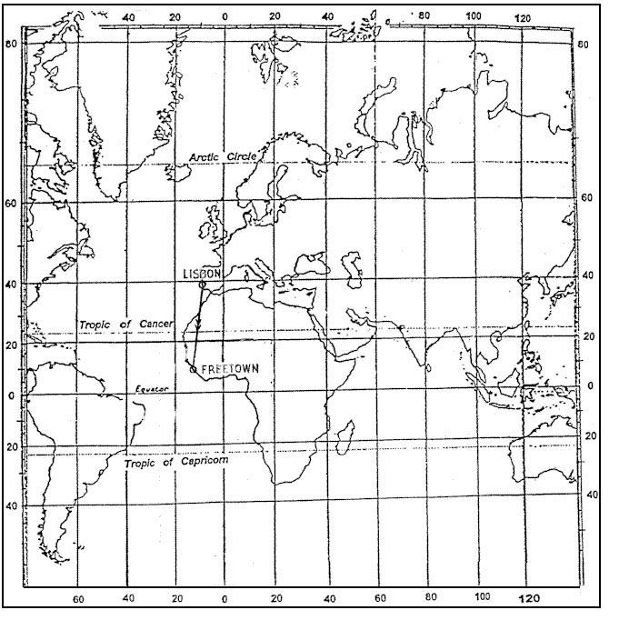
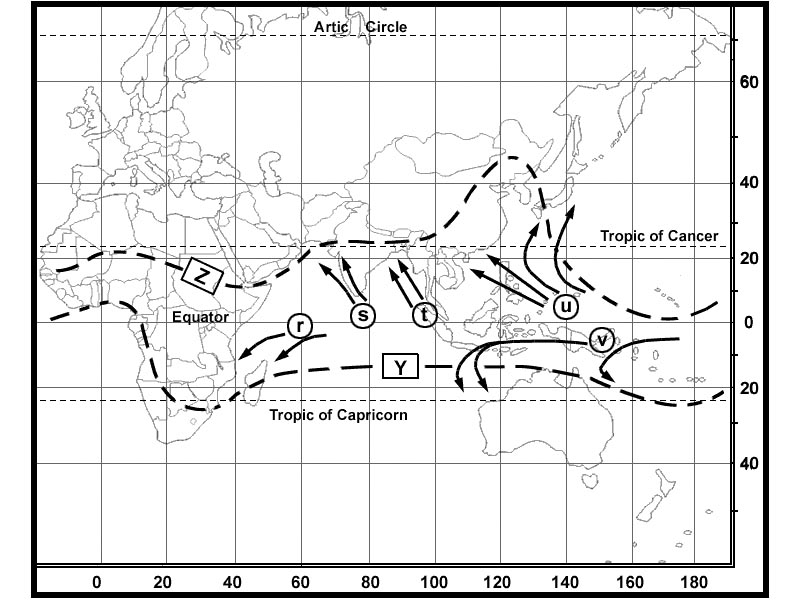
Question 170-24 : In the month of august you prepare a flight cruising level fl 370 from bombay 19°n 73°e to bangkok 13°n 100°e what wind conditions can you expect ?
Headwinds.
535you will face the tropical easterly jet at fl370Light winds diagonal to the route. tailwinds. strong northerly winds.
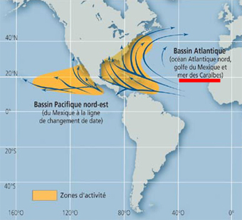
Question 170-25 : Tropical revolving storms do not occur in the southeast pacific and the south atlantic mainly because ?
Of the low water temperature.
By elimination there is no coriolis force at the equator only the coriolis force varies with latitudes 566in the southeast pacific the wind comes from nw the 'westerlies' 596se trade winds cross over into the northern hemisphere only between dakar and indian ocean up to the philippines 2537in the end tropical revolving storms do not occur in the southeast pacific and the south atlantic mainly because of the low water temperatureThere is no coriolis force present. of the strong southeast wind. the southeast trade winds cross over into the northern hemisphere.
Question 170-26 : What is the main energy source of a tropical revolving storm ?
Latent heat released from condensing water vapour.
Temperature difference between equatorial low pressure trough and subtropical high pressure belt. cold air advancing from temperate latitudes. the equatorial jet stream.
Question 170-27 : During july flights from bangkok 13°n 100°e to karachi 25°n 67°e experience an average tailwind component of 22 kt in january the same flights also operating at fl 370 have an average headwind of 50 ktwhat is the reason for this difference ?
The wind components correspond to the seasonal change of the regional wind system.
In july the tropical easterly jet at fl370 will push you sw monsoon from bangkok to karachi in january you will face the subtropical jet during the winter months in the northern hemisphere the polar front pushes farther southward because of the greater density of the polar air than during the summer monthsThe flights during the summer encountered, by chance, very unusual, favourable conditions. the flights in january encountered, by chance, very unusual, adverse wind conditions. the flights happen to be in the area of the polar front jet stream.
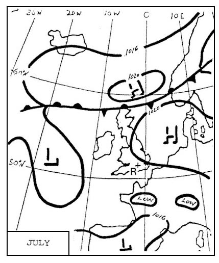
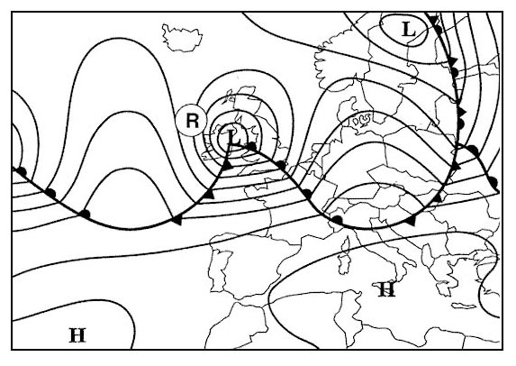
Question 170-28 : Which typical weather condition is shown by the design for the area of central europe 315 ?
Westerly waves.
A series of fronts or depressions one after the other is referred to as a westerly wave over central euoprethese systems move in the direction of the first two isobars in the warm sector which tend to be straight and parallel when the cold and warm fronts begin to occlude the direction of movement is increasingly towards the poleCutting wind. easterly waves. uniform pressure pattern.
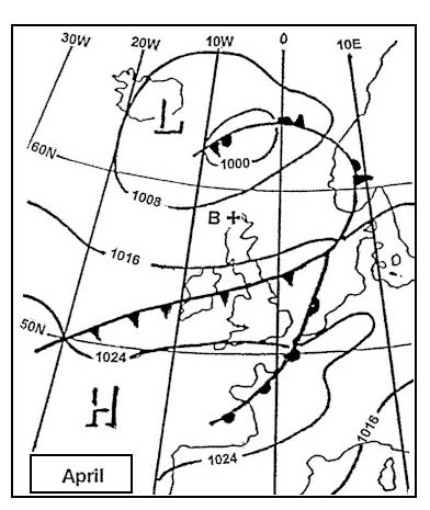
Question 170-29 : Which typical weather condition is shown by the design for northern italy 316 ?
High pressure.
As we can see an anticyclone is located over italyWarm southerly wind. westerly wind. easterly wind.
Question 170-30 : The attached chart shows the weather conditions on the ground at 1200 utc on october 10 which of the following reports reflects weather development at zurich airport 317 ?
We have a large flat pressure pattern an area with light or no wind zurich has therefore the lowest probability of precipitationradiation fog will occur at nightradiation fog is formed by the cooling of land after sunset by thermal radiation in calm conditions with clear skyno change in wind condition is expected for the next hours since the isohypses are well spacedTaf lszh 101500z 1016/1101 23012kt 6000 ra bkn012 ovc030 tempo 1020/1023 22025g40kt 1600 +snra bkn003 ovc015= taf lszh 101500z 1016/1101 32008kt 9999 sct030tcu tempo 1022/1101 32020g32kt 3000 tsra bkn020cb= taf lszh 101500z 1016/1101 05020g35kt 8000 bkn015 tempo 1017/1020 05018kt 0300 +shsn vv002=
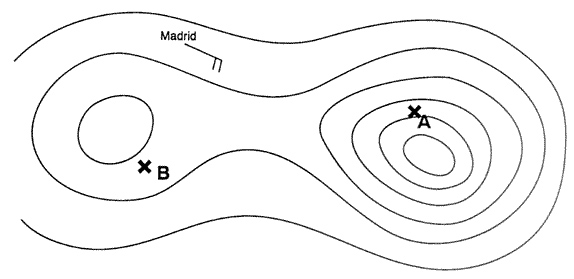
Question 170-31 : You are flying from east to west in the northern hemisphere at the 500 hpa pressure surface which of the following statements is correct ?
If the wind is from the north you are gaining altitude.
If you stand with your back to the wind in the northern hemisphere low pressure is on your left buys ballot's law 562you are flying toward a high you are gaining altitudeIf the wind is from the south you are gaining altitude. if you have a head wind you are gaining altitude. if you have a tail wind you are losing altitude.
Question 170-32 : Divergence in the upper air results near the surface in ?
Falling pressure and likely formation of clouds.
563divergence in the upper air means convergence on the ground this a low pressure area and clouds may appears above itRising pressure and likely dissipation of clouds. falling pressure and likely dissipation of clouds. rising pressure and likely formation of clouds.
Question 170-33 : In a low pressure system the convergence at the surface is caused by ?
Frictional forces.
498at the surface and at low elevations friction will slow the air and hence the coriolis will be less effective in its deflection of the windthe flow turns across the isobars you have more flow into the low pressure system giving convergence and feeding the convectionCentripetal forces. the inbalance of the horizontal gradient force and the coriolis force. the curvature of the isobars.
Question 170-34 : If the pressure surfaces bulge upwards in all levels then the pressure system is a ?
Warm high.
If isobars bulge up in all level you have a high pressure at the surface and high temperatures in the airCold low. cold high. warm low.
Question 170-35 : A cold air pool ?
Is usually most evident in the circulation and temperature fields of the middle troposphere and may show little or no sign on a surface chart.
Develops usually in winter when very unstable maritime polar or maritime arctic air currents stream southwards along the eastern side of an extensive ridge of high pressure, in association with occluded systems normally disappears at night and occurs almost exclusively in summer occurs frequently in winter to the south of the alps when this region is under the influence of cold north-westerly airstream
Question 170-36 : The stable layer at some height in the low troposphere of an older high pressure area in the mid latitudes is called ?
Subsidence inversion.
As the upper air sinks older high pressure subsides it warms 570this can lead to warmer air in the mid troposphere than at the surface this phenomenon is called subsidence inversionFriction inversion. radiation inversion. trade wind inversion.
Question 170-37 : A blocking anticyclone in the northern hemisphere is ?
A warm anticyclone quasi stationary situated between 50°n and 70°n.
The blocking anticyclones in the northern hemisphere are over the oceans these are parts of the belt of sub tropical high pressure formed over relatively warm ocean surfacesthey block the path of atlantic depressionsQuasi stationary, situated between 50°n and 70°n, a cold anticyclone. situated between 50°n and 70°n, a cold anticyclone, steering depressions. a cold anticyclone, steering depressions, situated over scandinavia.
Question 170-38 : Which statement is true for hurricanes in the north atlantic ?
From the earth's surface up to the tropopause the core is warmer than its surroundings.
They intensify rapidly after landfall. the diameter is 50-500 m. their greatest frequency of occurrence is in winter.
Question 170-39 : Assume that an aircraft is flying in the northern hemisphere at the 500 hpa pressure surface on a heading of 270 degreeswhich of the following statements is correct ?
If in this pressure surface the wind comes from the direction 360 degrees then true altitude is increasing.
If you stand with your back to the wind in the northern hemisphere low pressure is on your leftwith a wind coming from the direction 360 degrees and you stand with your back to it low pressure is on the easton a heading of 270 degrees we are flying towards high pressure thus true altitude is increasingIf in this pressure surface the wind comes from the direction 180 degrees, then true altitude is increasing. if in this pressure surface the wind comes from the direction 270 degrees, then true altitude is increasing. if in this pressure surface the wind comes from the direction 090 degrees, then true altitude is increasing.
Question 170-40 : An aircraft is flying at fl 180 in the northern hemisphere with a crosswind from the left which of the following is correct concerning its true altitude ?
It decreases.
If you stand with your back to the wind in the northern hemisphere low pressure is on your left buys ballot's law 573with a crosswind to the left must mean you are heading into an area with a lower temperature our true altitude decreasesIt increases. it remains constant. without knowing temperatures at fl 180 this question can not be answered.
Exclusive rights reserved. Reproduction prohibited under penalty of prosecution.