A free Premium account on the FCL.055 website! Read here
Sign up to unlock all our services and 15164 corrected and explained questions.
Question 177-1 : After a prolonged vmc descent in very cold air you penetrate a humid air mass what type of icing will you encounter ? [ Practice protocol ]
Hoar frost
Question 177-2 : An aircraft flies into supercooled rain in an area with a temperature below 0°c the type of icing it will most likely encounter is ?
Clear ice.
Hoar frost. rime ice. granular frost.
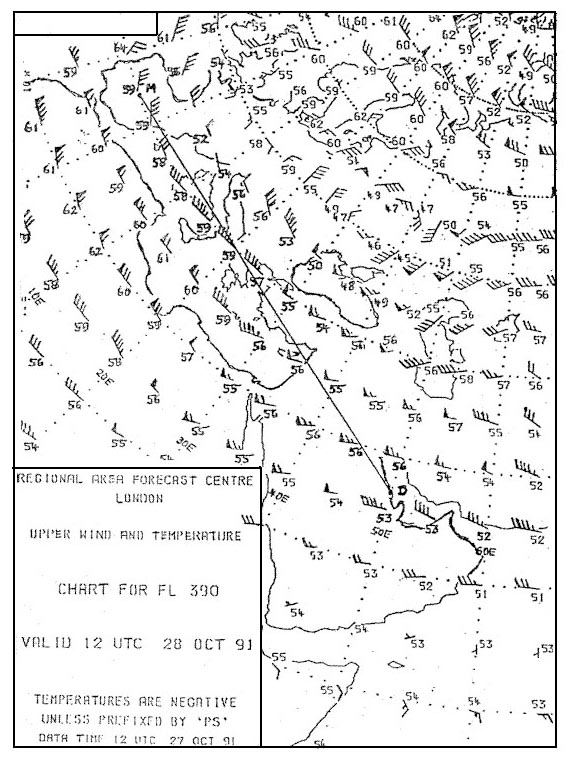
Question 177-3 : An aircraft flying at fl 45 oat 6°c obtains a reading of 1860 ft on its radio altimeter ground elevation 3090 ft what is the value of the qnh to the nearest hpa at that point ?
Question 177-4 : Assuming that an initial 'trigger' force is present the conditions most likely to result in the formation of thunderstorms are ?
High relative humidity and instability throughout a deep layer.
High surface temperature, low dew point and high dry adiabatic lapse rate. rapid orographic cooling of cloud containing ice crystals. intense surface heating, anticyclonic pressure system and relatively high freezing level.
Question 177-5 : Convective weather phenomena include ?
Thunderstorms hail tornadoes wind gusts heavy showers lightning strikes.
Thunderstorms, tornadoes, hail, haze, wind gusts, advection fog heavy showers, lightning strikes, hail, mist, squalls, light rain over a large area hail, lightning strikes, wind lulls, squalls, stratocumulus, low level wind maximum
Question 177-6 : For a vfr aircraft the conditions in which it could encounter severe airframe icing are ?
Flight into freezing rain resulting in clear ice formation.
Flight into supercooled rain, resulting in rime ice formation flight into an area outside of clouds where the temperature is below 0°c, resulting in rime ice formation flight between two cloud layers, without precipitation, resulting in clear ice formation
Question 177-7 : Hazardous hailstones reaching the ground are most likely to be experienced below cb clouds situated ?
In continental interiors in middle latitudes.
Hail can be met at any height in the cb since air temperature just above the sea equator and middle latitudes and above the ground near the equator is positive you are less likely to encounter hazardous hailstones below cb cloudssevere skin damage to the airframe can occur when the hail is large damaging hail can occur up to a height of 45000 feetOver the sea near the equator. in continental interiors near the equator. over the sea in middle latitudes.
Question 177-8 : Ice accretion to the airframe is likely to be most hazardous at temperatures ?
Between 0°c and 23°c in large cu.
The most severe icing is clear ice clear ice will form in stratus between 0ºc and 7ºc but in cumulus the larger droplet size will give clear ice at temperature between 0ºc and 23ºcBetween 0°c and -17°c in as. between 0°c and -17°c in st. below -40°c in cb.
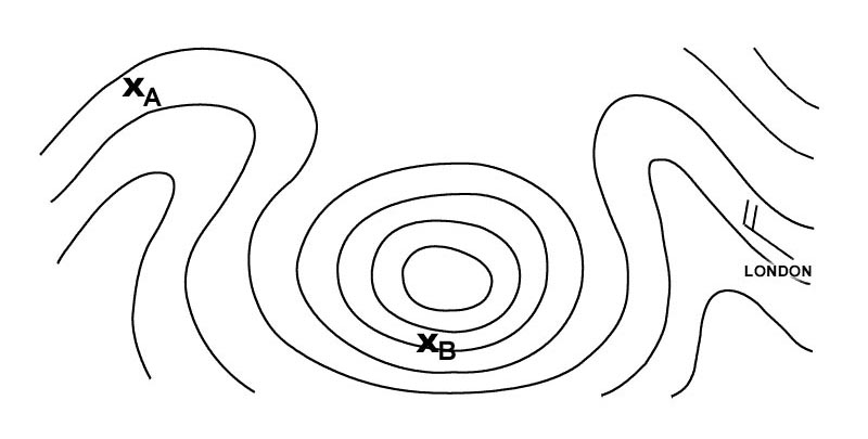
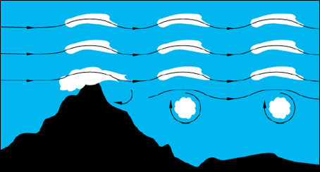
Question 177-9 : In a mountainous area the most hazardous flying conditions associated with standing waves are likely to be experienced ?
In the vicinity of the 'roll' cloud or rotor zone beneath the first wave on the leeward side.
On the windward side of the mountain just above the 'cap' cloud just above the lenticular cloud on the windward side between the troughs of the waves particularly 30 nm to 50 nm downwind and close to the tropopause
Question 177-10 : In addition to a stable layer of air over a substantial mountain range the conditions most favourable to the development of standing waves are ?
Wind speed excess of 20 kt at the surface and increasing with height wind direction perpendicular to the general direction of the range.
Standing waves = orographic waves = mountain waves 433in addition to a stable layer of air over a substantial mountain range the conditions most favourable to the development of standing waves are wind speed excess of 20 kt at the surface and increasing with height wind direction perpendicular to the general direction of the rangeSteep dry adiabatic lapse rate, wind speed increasing and changing direction rapidly with increase in height. conditional instability, wind speed constant from a direction parallel to the mountain range. significant moisture loss due to precipitation, rapid lowering of the tropopause in the area of the mountain range.
Question 177-11 : Mountain waves should be expected ?
On the downwind side of the mountain chain.
When instability is high. directly over the mountain chain. on the upwind side of the mountain chain.
Question 177-12 : The conditions most favourable to the formation of mountain waves are ?
Wind direction approximately at right angles to the mountain range wind speed 30 kt and steadily increasing with height an inversion just above the crest level with less stable air above and below.
The most favourable conditions are a strong wind perpendicular to the mountain increasing with altitude and a layer of stable air with less stable air above and below itWind direction parallel to the general alignment of the mountain range - wind speed increasing with height - intense surface heating. wind speed less than 15 kt and wind direction at right angles to mountains - intense radiation cooling at night particularly at the higher levels. wind direction parallel to the mountain range - wind speed increasing with height - extensive isothermal layer between mountain crests and the tropopause.
Question 177-13 : The formation of clear ice on the leading edges of an aircraft is most likely to be caused by the ?
Relatively slow freezing of large supercooled water droplets.
clear ice forms on an aircraft by the freezing of large supercooled water drops supercooled water droplets spreading travel back during the freezing process Instantaneous freezing of small supercooled water droplets. instantaneous freezing of large supercooled water droplets and snow crystals. relatively slow freezing of small supercooled water droplets and ice crystals.
Question 177-14 : Thunderstorms are often preceded by ?
Altocumulus castellanus.
The presence of altocumulus castellanus indicates instability in the middle troposphereNimbostratus. altostratus. altocumulus lenticularis.
Question 177-15 : Thunderstorms reach their greatest intensity during the ?
Mature stage.
Cumulus stage. dissipating stage. period in which precipitation is not falling.
Question 177-16 : What intensity and type of airframe icing is most likely to occur when aircraft descend rapidly from fl 320 temperature 45°c to fl 60 in warm moist clear air ?
Question 177-17 : What intensity and type of airframe icing is most likely to occur when flying at fl 170 in as with the outside air temperature at 20°c ?
Light rime.
Severe - clear. moderate - hoar frost. moderate - clear.
Question 177-18 : What is a microburst downburst ?
A concentrated downdraft with high speeds and a lower temperature than the surrounding air.
A microburstdownburst is a localized area of damaging winds caused by air rapidly flowing down and out of a thunderstorm a microburst occurs when cold air high in a thunderstorm descends and accelerates as the stream of cold air reaches the ground it spreads out and can accelerate even furtherA concentrated downdraft with high speeds and a higher temperature than the surrounding air. an extremely strong wind gust in a tropical revolving storm. a small low pressure system where the wind circulates with very high speeds.
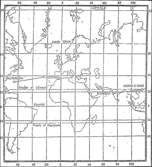
Question 177-19 : What visibility is most likely to be experienced at 1400 utc eddf 272200z 280624 vrb05kt4000 br sct005 ovc013 becmg 1314 9000 shra ovc015 prob40 tempo 1416 vrb15g25kt 1600 tsra ovc010cb becmg 1618 26010kt bkn030 becmg 2122 cavok ?
9000 metres.
4000 metres 1000 metres 1600 metres
Question 177-20 : Which statement is correct concerning a mountain ridge where a marked mountain wave has been reported ?
Ragged altocumulus lenticularis is an indication for the presence of moderatesevere turbulence at the level of these clouds.
The atmosphere is unstable at the level of the mountain tops. there are always rotor clouds. the axis of a rotor is horizontal and perpendicular to the mountains
Question 177-21 : Which thunderstorms move forward the fastest ?
Frontal thunderstorms.
Orographic thunderstorms. thermal thunderstorms. thunderstorms formed by lifting processes.
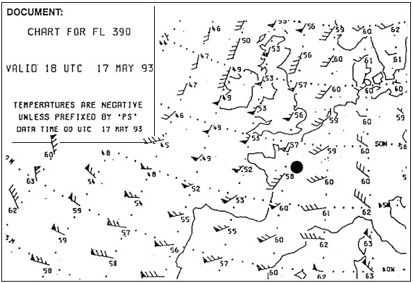
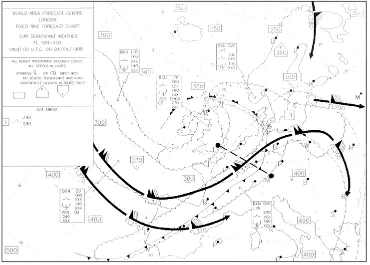
Question 177-22 : Which weather chart gives information about icing ?
Significant weather chart.
500 hpa chart. surface chart. 700 hpa chart.
Question 177-23 : Lenticular clouds in mountainous areas indicate ?
Turbulence.
Unstable air. an inversion. light variable winds.
Question 177-24 : Which of the following statements about lightnings and lightning strikes is correct ?
The aircraft is temporarily part of the lightning trajectory.
Spherical lightnings often penetrate into aircraft. compasses and electronics are always affected lightning strikes always cause heavy damage.
Question 177-25 : Which of the following situations favours the formation of heavy thunderstorms ?
A cold front approaching a mountain range in the evening.
The passage of a warm front in the morning. a cold front on the leeward side of a mountain range. a warm sector moving over a snow-covered ground.
Question 177-26 : With the development of a thunderstorm at what stage will there be only updraughts of air ?
Initial stage.
Mature stage. anvil stage. dissipating stage.
Question 177-27 : Where does wind shear occur ?
At any level in the atmosphere if associated with either a change of wind direction andor wind speed.
Wind shear of any significance occurs only in connection with jetstreams. wind shear occurs primarily at lower altitudes in the vicinity of mountain waves. wind shear occurs only when there is a strong temperature inversion, or when the jetstream is associated with a strong depression.
Question 177-28 : When severe mountain waves are present where would the area of most severe turbulence be located ?
In the rotor zone.
The turbulence associated with a mountain wave is in the rotor zone 610Just above the cap cloud. on the windward side of the mountain range. just below the tropopause.
Question 177-29 : Taf lszh 250600z 250716 00000kt 0100 fg vv001 becmg 0810 0800 vv002 becmg 1012 23005kt 2500 br bkn005 tempo 1316 6000 sct007 =which of these statements best describes the weather that can be expected at 1200 utc ?
Question 177-30 : Which statement is correct for microbursts ?
The diameter of the affected area on the surface does not exceed 4 km.
A microburstdownburst is a localized area of damaging winds caused by air rapidly flowing down and out of a thunderstorm a microburst occurs when cold air high in a thunderstorm descends and accelerates as the stream of cold air reaches the ground it spreads out and can accelerate even furtherThey only develop below convective clouds with heavy rain. they occur in the tropics only. their downdraft is warmer than the surroundings.
Question 177-31 : Which statement does correspond to the definition of severe turbulence ?
Aircraft may be out of control for short periods occupants are forced violently against seat belts loose objects are tossed about.
Moderate conditions in which moderate changes in aircraft attitude andor altitude may occur but the aircraft remains in positive control at all times usually small variations in airspeed changes in accelerometer readings of 05 g to 10 g at the aircraft's centre of gravity difficulty in walking occupants feel strain against seat belts loose objects move aboutsevere conditions in which abrupt changes in aircraft attitude andor altitude occur aircraft may be out of control for short periods usually large variations in airspeed changes in accelerometer readings greater than 10 g at the aircraft's centre of gravity occupants are forced violently against seat belts loose objects are tossed aboutDifficulty in walking, occupants feel strain against seat belts, loose objects move about. aircraft gets out of control and crashes. aircraft will be damaged and an emergency landing will be absolutely necessary.
Question 177-32 : What is the lowest visibility forecast for approach into geneva eta 1200 utc taf lsgg 020900z 021019 18007kt 9999 sct020 bkn100 becmg 1114 8000 ra sct010 ovc020 prob30 tempo 1018 vrb10g25kt tsra sct005 bkn015cb= ?
8 km.
8 nm. 6 nm. 10 km.
Question 177-33 : Which thunderstorms generally produce the most severe conditions such as heavy hail and destructive winds ?
Squall line thunderstorms.
When many individual thunderstorms organize into a nearly continuous line a squall line is born they can be more than 80 nm long and often form 40 to 130 nm ahead of advancing cold fronts racing along squall line thunderstorms blast the ground with torrents of rain and hail driven by winds gusting higher than 50 ktWarm front thunderstorms. nocturnal air mass thunderstorms. daytime air mass thunderstorms.
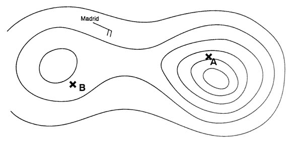
Question 177-34 : What visibility is most likely to be experienced during an approach into madrid at 2300 utc taf lemd 281200z 281812 13005kt cavok tempo 1821 8000 sct020 sct030 becmg 2123 21005kt 9999 sct015 bkn080 prob40 tempo 2306 6000 sct008 ?
10 kilometres or more.
The tempo group is used for any conditions in wind visibility weather or sky condition which are expected to last for generally less than an hour at a time occasional and are expected to occur during less than half the time period the tempo indicator is followed by a four digit group giving the beginning hour and ending hour of the time period during which the temporary conditions are expected only the changing forecast meteorological conditions are included in tempo groups the omitted conditions are carried over from the previous time groupthus the most likely visibility to be experienced during an approach into madrid at 2300 utc is 10 kilometres or more8000 metres. 6000 metres. 4000 metres.
Question 177-35 : What is the lowest visibility that may be expected during an approach into dhahran at eta 0600 utc taf oedr 280000z 280110 vrb08kt cavok becmg 0103 7000 tempo 0410 28014g24kt 4000 sa= ?
4 km.
10 km or more. 7 km. 6000 m.
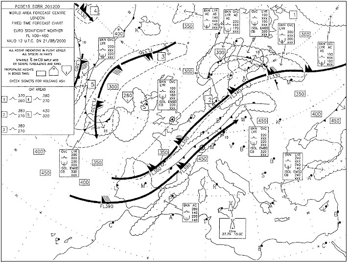
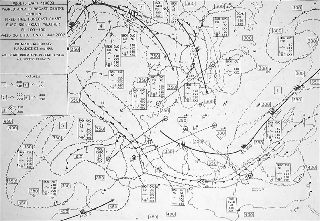
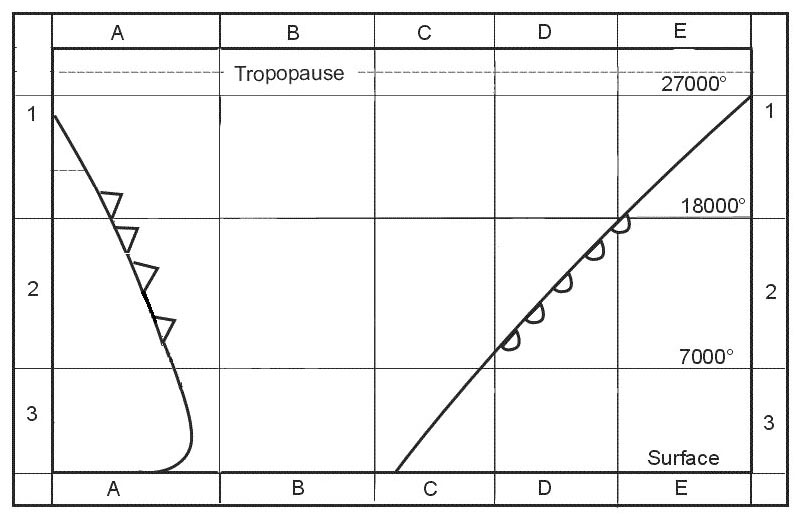
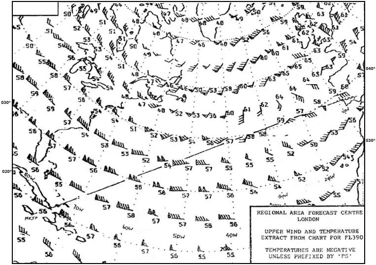
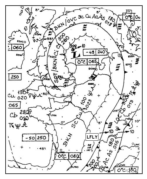
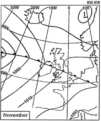
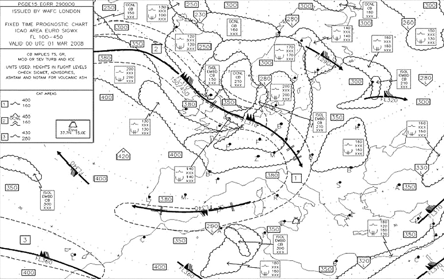
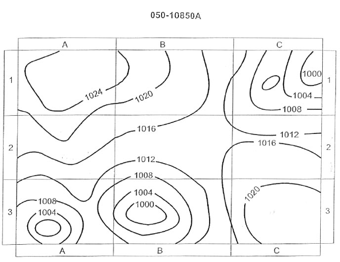
Question 177-36 : In which squares are conditions most likely to cause the occurrence of low level wind shear 329 ?
3 a and 3 c.
3 a and 3 b. 3 b and 3 c. 3 b and 3 d.
Question 177-37 : For an aircraft making an approach to an airfield which is not situated near high ground in the vicinity of the active front in square 3 b a potential hazard exists in the form of 346 ?
Low level wind shear.
Radiation fog. rotor streaming. clear air turbulence (cat).
Question 177-38 : The occurrence of freezing rain at fl 60 is most likely in square 347 ?
3c.
At fl 60 in square 3c the aircraft will be at the cold air freezing level and this would be the most likely area to encounter freezing rain 505freezing rain is associated with warm fronts and warm occlusions in a warm front the freezing level is lower than behind in the warm sector and the slope means that freezing rain will be falling on anything underneathin square 2a and 2d you are above fl 702d. 3b. 2a.
Question 177-39 : For an aircraft at fl 40 approaching the front square 3c from the direction of square 3d a potential hazard exists before reaching the front in the form of 351 ?
Clear ice accretion to the airframe.
At fl 40 the aircraft will be close to the cold air freezing level and this would be the most likely area to encounter freezing rain 505freezing rain is associated with warm fronts and warm occlusions in a warm front the freezing level is lower than behind in the warm sector and the slope means that freezing rain will be falling on anything underneathSevere turbulence associated with cb. severe turbulence and wind shear. severe downdrafts from subsiding air.
Question 177-40 : What are the characteristics of rime ice and what conditions are most favourable for its formation ?
Milky granular appearance forming on leading edges and accumulating forward into the air stream stratiform clouds at temperatures of 10°c to 20°c are most conducive to its formation.
Opaque rough appearance, tending to spread back over an aircraft surface. most frequently encountered in cumuliform clouds at temperatures slightly below freezing. smooth appearance and builds forward from leading surfaces into a sharp edge. most common in cumuliform clouds at temperatures of -20°c to -25°c. transparent appearance and tendency to take the shape of the surface on which it freezes. stratiform clouds and temperatures only slightly below freezing promote its formation.
Exclusive rights reserved. Reproduction prohibited under penalty of prosecution.