A free Premium account on the FCL.055 website! Read here
Sign up to unlock all our services and 15164 corrected and explained questions.
Question 179-1 : During an ils approach on rwy 33 a northwesterly wind is blowing parallel to the runway its speed is decreasing rapidly with height while its change in direction is negligible what has the pilot to be aware of with respect to wind shear and glide path no autopilot engaged ? [ Practice protocol ]
Without the pilot's intervention the aircraft is likely to fly above the designated glide path with increasing deviation from it
Question 179-2 : Which of the following statements regarding an aircraft being struck by lightning is true ?
The flight crew might have temporary difficulties in determining the current attitude of flight.
The crew of an aircraft made of conductive material (e.g. metal) will generally suffer greater adverse effects due to lightning discharge than the crew of an aircraft made of non-conductive composite material. though flying through an electric field, the aircraft itself is not a charge carrier and therefore it cannot initiate a lightning discharge. the dimension of the damage caused by the lightning stroke is reciprocally proportional to the strength of the electric field the aircraft intruded.
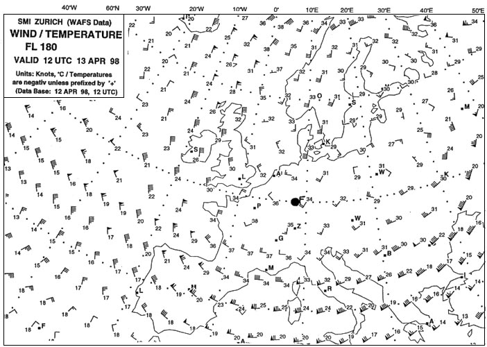
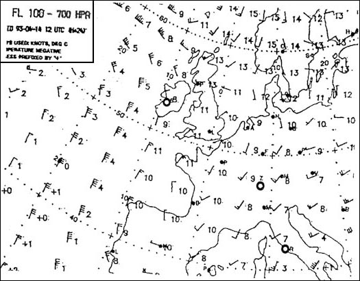
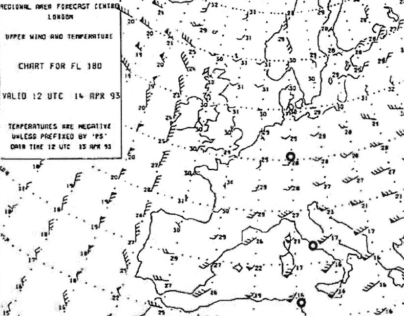
Question 179-3 : For this question use annex 050 047 on which of these routes would you not need to worry about icing at fl 180 393 ?
Bordeaux zurich.
Ecqb03 july 2016Frankfurt - madrid helsinki - copenhagen shannon - stockholm
Question 179-4 : Compared to a microburst a macroburst ?
Affects a larger area.
Occurs over a shorter time period. has an updraft. is free of rain.
Question 179-5 : An aircraft in straight and level flight may suddenly experience clear air turbulence cat which may ?
Cause abrupt changes in attitude andor height resulting in injuries to passengers and crew aircraft may be out of control for short period.
Ecqb03 july 2016Lead to problems with the engine performance, as the flow of liquids (fuel, coolant, etc) may be altered. damage its the control surfaces, especially if the aircraft flies at the upper limits of its service ceiling. impair the function of its electronics (avionics, instruments) to such an extend that an immediate landing is necessary.
Question 179-6 : Which of the following statements is correct concerning rotors below the crest of a mountain wave ?
The wind direction at the lower side of the rotors is opposite to the prevailing wind direction.
Ecqb03 august 2016The wind direction at the top of the rotors is opposite to the prevailing wind direction. the axis of these rotors is vertical. the rotors are always visible by the presence of rotor clouds.
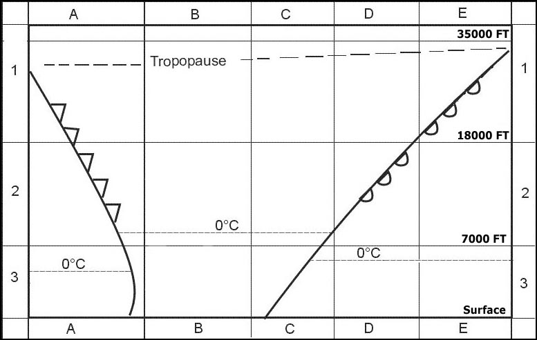
Question 179-7 : Which of these statements about turbulence are correct or incorrect 1 above the tropopause the risk of cat is zero2 convective turbulence is always indicated by convective clouds ?
1 and 2 are incorrect.
Ecqb03 august 20161 and 2 are correct. 1 is correct, 2 is incorrect. 1 is incorrect, 2 is correct.
Question 179-8 : If a thunderstorm cb 10 nm ahead is assessed as still being in the mature phase what should a pilot of a light aircraft do ?
He should change heading to circumnavigate the storm.
Ecqb03 august 2016He should start a descent in order to pass underneath the storm. he should climb above the storm. he should cross the storm on the shortest possible way.
Question 179-9 : Which of these statements about turbulence are correct or incorrect 1 severe cat may be expected in the core of a jet stream2 at 500 ftagl mechanical turbulence does occur more often than at 5000 ftagl ?
1 is not correct 2 is correct.
Ecqb03 august 20161 and 2 are correct. 1 and 2 are not correct. 1 is correct, 2 is not correct.
Question 179-10 : Check the correctness of the following statements 1 outside clouds no severe aircraft icing can occur2 hoar frost consists of ice crystals formed on a surface by sublimation ?
1 is correct 2 is correct.
Ecqb03 august 20161) is not correct 2) is not correct. 1) is not correct 2) is correct. 1) is correct 2) is not correct.
Question 179-11 : On which route of flight would you expect no icing at fl 180 401 ?
Hamburg stockholm.
The flight from hamburg to stockholm will be out of cloud and out of area where icing is reported 458Zurich-madrid. zurich-hamburg. zurich-vienna.
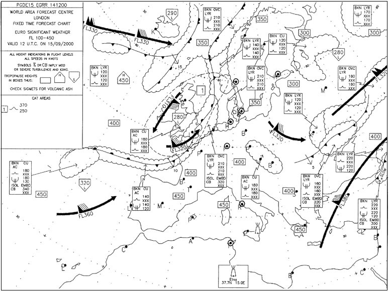
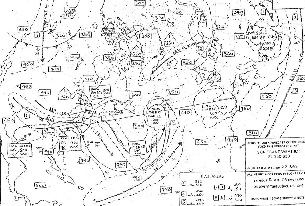
Question 179-12 : If you are flying from zurich to london at fl 220 what conditions can you expect at cruising altitude 402 ?
Scattered thunderstorms.
You have embedded cbs from below fl100 chart goes from fl100 to fl450 up to fl280icing and turbulence only go up to fl150Prolonged severe turbulence and icing throughout the flight. cat for the first half of the flight. flight largely in cloud, no turbulence.
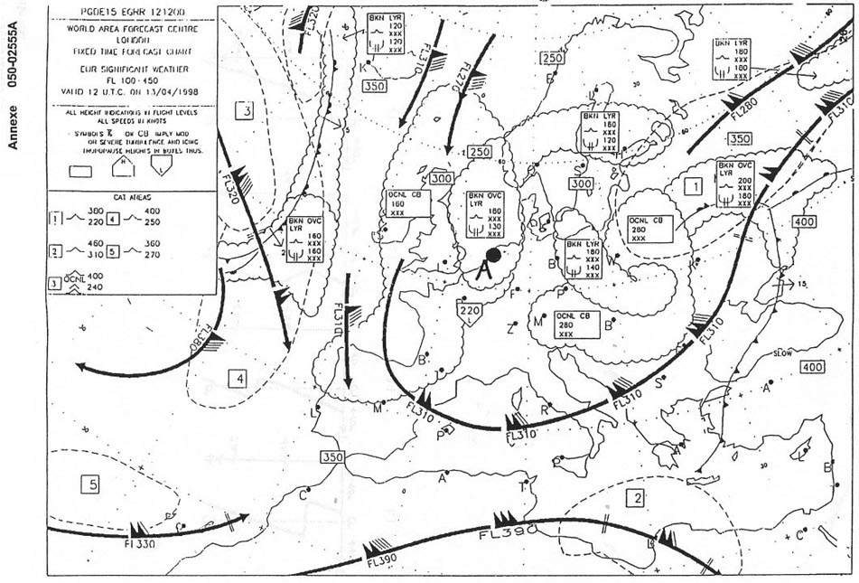
Question 179-13 : Which route is free of turbulence at fl 340 404 ?
Shannon hamburg.
459this is the only route that do not cross cat aera n°1Zurich-rome rome-berlin zurich-athens
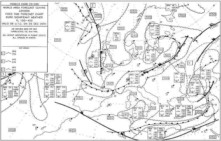
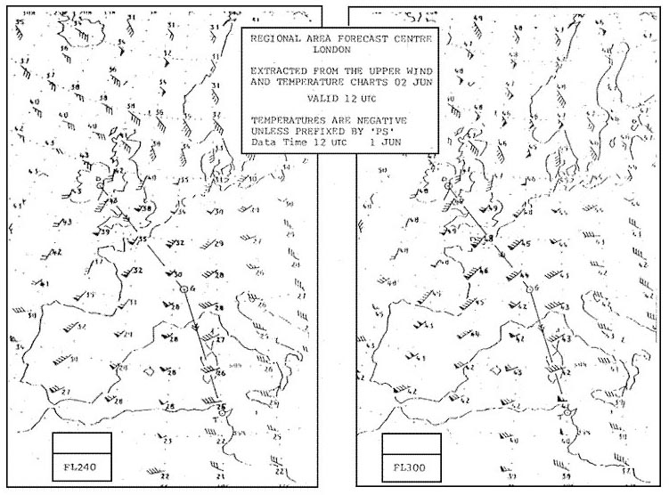
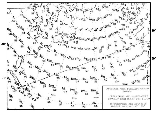
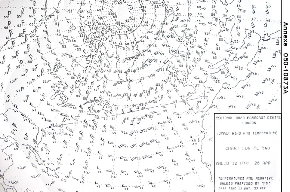
Question 179-14 : What is the lowest flight level that is forecast to be subject to clear air turbulence on the route from valencia to charleston 405 ?
Fl 250.
Fl 380. fl 350. fl 320.
Question 179-15 : What is the greatest intensity of turbulence i and icing ii that can be expected on the route from valencia to charleston at fl 330 407 ?
I severe ii severe.
(i) severe, (ii) moderate. (i) moderate, (ii) severe. (i) moderate, (ii) light.
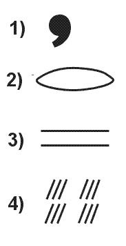
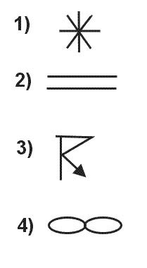
Question 179-16 : According to icao which symbol indicates danger to an aircraft in flight 420 ?
1.
Icao annex 3 meteorological service for international air navigation 5472) 3) 4)
Question 179-17 : What is the relationship between visibility and rvr in homogeneous fog ?
The visibility is generally less than the rvr.
The methods for measuring rvr and prevailing visibility are quite different rvr is measured in a specific direction usually using transmissiometers while the prevailing visibility will be the average and if less than 1500 m the minimum value in a specific direction this means that there can be no direct comparison and rvr is likely to be the same as or greater than the lowest reported value of prevailing visibilityThe visibility generally is greater than the rvr. the visibility generally is the same as the rvr. there is no specific relationship between the two.
Question 179-18 : When is the rvr reported at most airports ?
When the visibility decreases below 1500 m.
Annex 3 meteorological service for international air navigation rvr is reported when visibility is less than 1500 mWhen the visibility decreases below 2000 m. when the rvr decreases below 2500 m. when the rvr decreases below 2000 m.
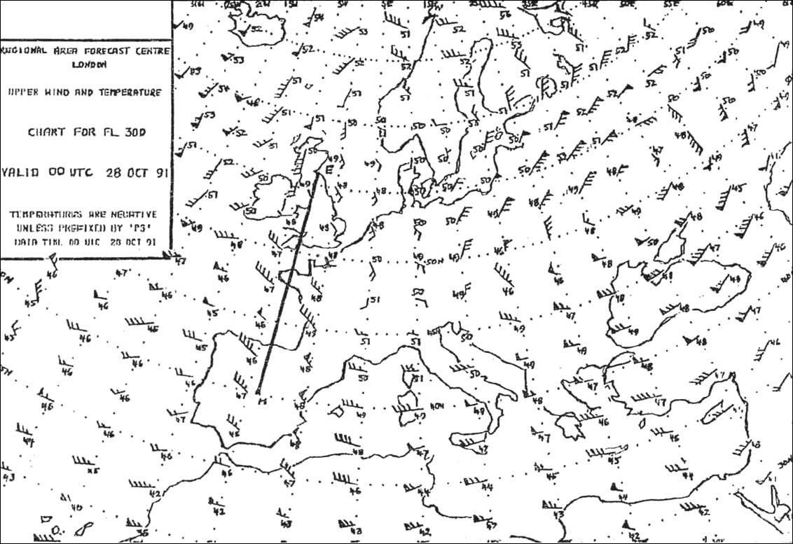
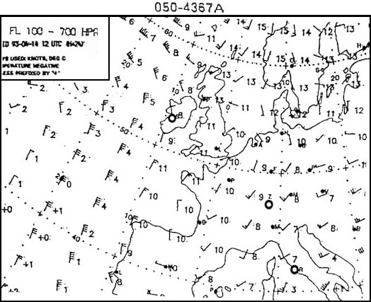
Question 179-19 : How is the direction and speed of upper winds described in forecasts ?
The direction is relative to true north and the speed is in knots.
The direction is relative to magnetic north and the speed is in knots. the direction is relative to magnetic north and the speed is in miles per hour. the direction is relative to true north and the speed is in miles per hour.
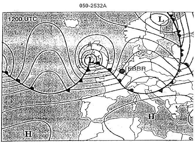
Question 179-20 : What positions are connected by contour lines on a weather chart ?
Positions with the same height in a chart of constant pressure.
Positions with the same thickness between two constant pressure levels. positions with the same air density. positions with the same wind velocity.
Question 179-21 : In which meteorological forecast chart is information about cat regions found ?
Significant weather chart.
522cat areas on a significant weather chart swc example for cat n°2 you will encountered moderate turbulence between fl220 to 40024 hour surface forecast. 500 hpa chart. 300 hpa chart.
Question 179-22 : The isobars drawn on a surface weather chart represent lines of equal pressure ?
Reduced to sea level.
At flight level. at height of observatory. at a determined density altitude.
Question 179-23 : Which constant pressure altitude chart is standard for fl50 ?
850 hpa.
There is a few questions in the exam that take information directly from that table below write these down on a sticky and have them on the wall beside you 1013 hpa = msl850 hpa = fl50700 hpa = fl100500 hpa = fl180300 hpa = fl300200 hpa = fl390any others you can interpolate between these and figure it outthe decrease of 1hpa27ft is only applicable at the lower levels of the troposphere as you go up and air pressure decreases the change of height per 1 hpa increases at msl 1hpa27ft at fl180 it's 50fthpa and at fl390 it's 105fthpa 500 hpa. 700 hpa. 300 hpa.
Question 179-24 : On which of the following aviation weather charts can a pilot most easily find a jetstream ?
Significant weather chart.
522the large black lines are jetstreamsWind / temperature chart. surface chart. upper air chart.
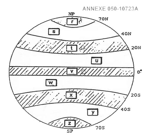
Question 179-25 : Why are indications about the height of the tropopause not essential for flight documentation in the tropics ?
The tropopause is generally well above the flight level actually flown.
The meteorological services are unable to provide such a chart. the temperatures of the tropical tropopause are always very low and therefore not important. the tropopause is always at the same height.
Question 179-26 : In the taf for delhi during the summer for the time of your landing you note tempo tswhat is the maximum time this deterioration in weather can last in anyone instance ?
60 minutes.
The change indicator 'tempo' and the associated time group should be used to describe expected frequent or infrequent temporary fluctuations in the meteorological conditions which reach or pass specified threshold values and last for a period of less than one hour in each instance and in the aggregate cover less than one half of the forecast period during which the fluctuations are expected to occur120 minutes. 10 minutes. 20 minutes.
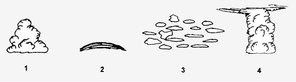
Question 179-27 : How are well separated cb clouds described on the significant weather chart ?
Ocnl cb.
It comes from annex 3 meteorological service for international air navigation appendix 6 511Embd cb. frq cb. isol cb.
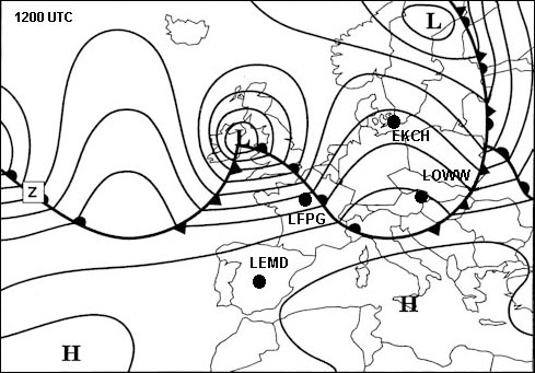
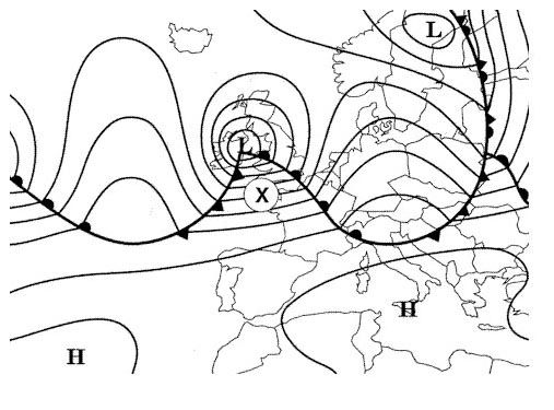
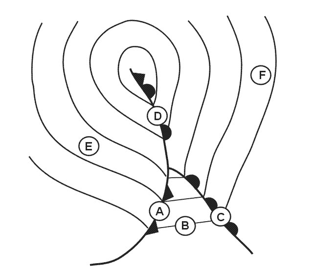
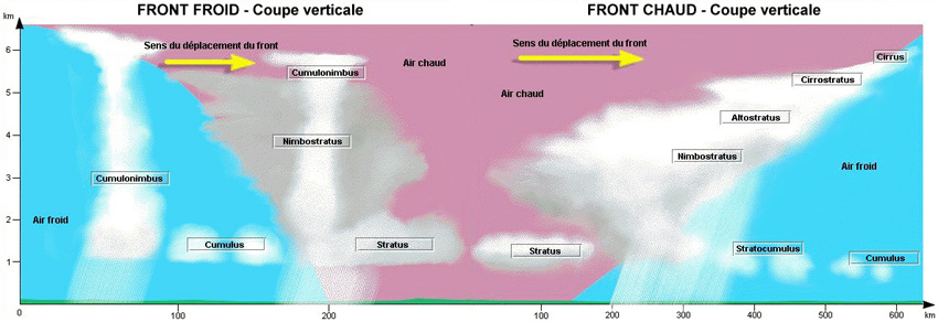
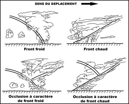
Question 179-28 : The cold front is indicated with a number at position 254 ?
N°2.
N°3. n°4. n°1.
Question 179-29 : What does the symbol indicate on a significant weather chart 256 ?
The center of a tropopause 'high' where the tropopause is at fl 400.
The lower limit of the tropopause. the upper limit of significant weather at fl 400. the center of a high pressure area at 400 hpa.
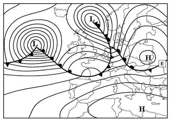
Question 179-30 : Which typical weather situation is shown on the weather chart spacing of the isobars 5 hpa 257 ?
Flat pressure pattern.
Isobars are well spaced we have large pools areas the pressure pattern is very flatCutting wind. west wind condition. warm south wind condition (foehn).
Question 179-31 : Which of the following weather reports is a warning of conditions that could be potentially hazardous to aircraft in flight ?
Sigmet.
Icao annexe 3 met services sigmet or significant meteorological information is a weather advisory that contains meteorological information concerning the safety of all aircraftthe following are examples of weather phenomena that may be described in a sigmet thunderstorms cyclones tropical revolving storms severe turbulence severe icing severe mountain waves dust or sand storms volcanic ashAtis. speci. taf.
Question 179-32 : In which of the following circumstances is a sigmet issued ?
Severe mountain waves.
Icao annexe 3 met services sigmet or significant meteorological information is a weather advisory that contains meteorological information concerning the safety of all aircraftthe following are examples of weather phenomena that may be described in a sigmet thunderstorms cyclones tropical revolving storms severe turbulence severe icing severe mountain waves dust or sand storms volcanic ashFog or a thunderstorm at an aerodrome. clear ice on the runways of an aerodrome. a sudden change in the weather conditions contained in the metar.
Question 179-33 : Does the following report make sense metar lszh 182320z vrb02kt 5000 mifg 0202 q1015 nosig ?
The report is possible because shallow fog is defined as a thin layer of fog below eye level.
Mi shallow fog bc patches of pr partial are only used with fg fog icao annex 3 44 present weather mi less than 2 m 6 ft above ground levelthe answer the report is possible because shallow fog is defined as a thin layer of fog below eye level is an acceptable definitionThe report would never be seen, because shallow fog is not reported when the visibility is more than 2 km. the report is nonsense, because it is impossible to observe a visibility of 5 km if shallow fog is reported. the report is not possible, because, with a temperature of 2°c and a dew point of 2°c there must be uniform fog.
Question 179-34 : You receive the following metar lsgg 120750z 00000kt 0300 r050700n fg vv001 m02m02 q1014 nosig = what will be the rvr at 0900 utc ?
The rvr is unknown because the nosig does not refer to rvr.
Geneva metar valid on the 12th day of the month at 07h50 utc no wind runway 05 visbility 700m no distinct tendency fog vertical visibility temperature 2°c and dew point 2°c qnh 1014 no change is expectedicao annex 3 the trend forecast at the end of the metar shall indicate significant changes in respect of one or more of the elements surface wind visibility weather and clouds only those elements shall be included for which a significant change is expected however in the case of significant changes in respect of cloud all cloud groups including layers or masses not expected to change shall be indicated in the case of a significant change in visibility the phenomenon causing the reduction of visibility shall also be indicated when no change is expected to occur this shall be indicated by the term nosig 300 m. 700 m. 900 m.
Question 179-35 : What positions are connected by isobars on the surface weather chart ?
Positions with the same air pressure at a given level.
Positions with the same temperature at a given level. positions with the same wind velocity at a given level. positions with the same relative pressure heights.
Question 179-36 : What is a trend forecast ?
A landing forecast appended to metarspeci valid for 2 hours.
An aerodrome forecast valid for 9 hours a route forecast valid for 24 hours a routine report
Question 179-37 : What does the expression 'broken bkn ' mean ?
5 7 eights of the sky is cloud covered.
3-4 eights of the sky is cloud covered. 3-5 eights of the sky is cloud covered. nil significant cloud cover.
Question 179-38 : What does the abbreviation 'nosig' mean ?
No significant changes.
No report received. no weather related problems. not signed by the meteorologist.
Question 179-39 : In which weather report would you expect to find information about icing conditions on the runway ?
Metar.
Sigmet gafor taf
Question 179-40 : In which of the following 1850 utc metar reports is the probability of fog formation in the coming night the highest ?
Vrb01kt 8000 sct250 1110 q1028 becmg 3000 br =.
Light wind below 5 kt little or no cloud clear night only one degree between temperature and dew pointvisibilty will fall from 8000 m to 3000 m and br mist indicates moist airthis conditions will lead to the formation of radiation fog moist air over land with heat loss from the ground on clear nights 22004kt 6000 -ra sct012 ovc030 17/14 q1009 nosig = vrb02kt 2500 hz sct120 14/m08 q1035 nosig = 00000kt 9999 sct300 21/01 q1032 nosig =
Exclusive rights reserved. Reproduction prohibited under penalty of prosecution.