A free Premium account on the FCL.055 website! Read here
Sign up to unlock all our services and 15164 corrected and explained questions.
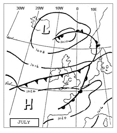
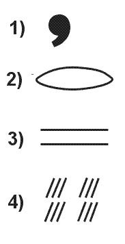
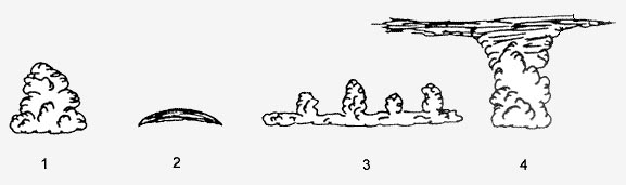
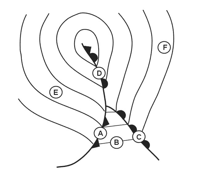
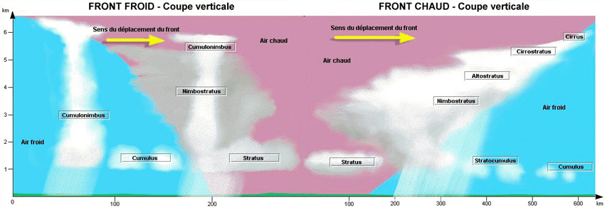
Question 183-1 : Which of the following symbols represents a quasi stationary front 383 ? [ Question security ]
Symbol 3
Question 183-2 : Which kind of meteorological messages are normally transmitted in an atis ?
Met report special.
Local routine met report and local special special reports are given by an atisfor local routine and special reports the present weather information should be representative of conditions at the aerodromeTaf / speci airmet / gamet metar / speci
Question 183-3 : What is the meaning of the different coloured areas on a plan position indicator of an airborne weather radar ?
Different ranges of intensities of precipitation.
Different ranges of cloud thickness (vertical extent). different horizontal dimensions of clouds. different intensities of turbulence (light, moderate, severe) within clouds.
Question 183-4 : What name is given to the jet stream lying over scandinavia c 385 ?
Question 183-5 : Below is the forecast for the destination of a flight whose eta is 2030 utctaf yudo 120600z 121206 17010kt 3000 sct005 becmg 1820 vrb03kt bcfg skc becmg 2022 0300 fg vv002=what can be said about the destination airport at 2030 utc if cat ii ils minima 350 m rvr 100 ft decision height are being ?
Has to be considered as closed.
Becmg 2022 0300 fg vv002=becoming between 20h and 22h visbility 300 m fog vertical visibility 200 fta meteorological visibility to rvr conversion is not used for category ii or iii minima thus with only 300 m of horizontal visibility the destination airport at 2030 utc has to be considered as closedStill open until 2200 utc because the weather change is not completed before 2200 utc. open the whole night because 300 m of visibility corresponds to at least 900 m rvr. still open because the decrease of the visibility below the cat ii minima will be a little bit later than 2030 utc.
Question 183-6 : A flight with a jet aeroplane from munich to london is planned with a departure time of 2250 local time which type of satellite imagery available with observation time close to etd is best to locate the clouds and the exact position of a cold front forecast for this night over western europe ?
Infrared ir polar orbiting.
Polar orbiting satellites orbit the earth at an altitude of approximately 850 km since they complete one orbit every 105 minutes the satellites circle the earth 14 times a day because of the orbital shift resulting from the planet's rotation they move west by approximately 2 time zones per orbitvisual this is basically a photo of the clouds and is only available during daylight hours infra red measures the heat thermal footprint of areas of cloud or the earth's surface if clouds are thin or absent and can be used both day and night geostationary satellites orbit the earth at about 36000 km of altitude over the equator they are called geostationary because their position does not change with respect to a point on the surface of the earthpolar orbiting satellites are close to the surface they provide the best information to locate the clouds and the exact position of a cold frontVisual (vis), geo-stationary. water vapour (wv), geo-stationary or polar orbiting. visual (vis), polar orbiting.
Question 183-7 : What is a volmet broadcast ?
Provision as appropriate of current metar speci taf and sigmet by means of continuous and repetitive voice broadcast.
Ecqb01 2013Weather information transmitted continuously via radio (special broadcast), containing weather information for one airport. that part of an atis which is concerned to meteorological information. information issued by a meteorological watch office concerning the occurrence or expected occurrence of specified enroute weather phenomena which may affect the safety of aircraft operations.
Question 183-8 : Which of the following statements concerning the use of airborne weather radar in the vicinity of thunderstorms is true ?
Accurate assessment of the weather ahead of the aircraft might be hampered due to the attenuation of the radar echoes by heavy rain.
Ecqb01 2013The radar reflectivity echoes are much more determined by the number of reflecting particles than by the particle size. the antenna tilt shall be adjusted in order to receive the most significant echoes (generally received from an altitude of approximately 30000 ft). the most significant echoes will be received due to lightning discharges near the freezing level.
Question 183-9 : An aircraft encounters atmospheric conditions in which abrupt changes of attitude and altitude of the aircraft occur changes in accelerometer readings go up to 12 g measured at the aircraft's centre of gravity lose objects inside the aircraft are tossed aboutwhich report if any is required ?
Special air report.
Ecqb01 2013No air-report is necessary. flight safety report. routine air-report.
Question 183-10 : What is the meaning of the following weather message cnl ws wrng 1 211130211330= ?
The first wind shear warning on the 21st of that month issued at 1130 utc has been cancelled at the same day at 1330 utc.
Cnl for cancelledws for windshearwrng for warning1 for first warning message of the day211130211330 issued at 1130 utc cancelled at 1330 utc the same day= end of the messagethe explanations for the abbreviations can be found in the procedures for air navigation services icao abbreviations and codes pans abc doc 8400 The first wind shear warning on the 21st of that month with an occasional intensity has a forecast validity from 1130 until 1330 utc. the weather warning with the number 121 concerning a cyclone at low levels has a validity time from 1130 until 1330 utc. this message cancels all weather warnings issued on the 21st of january between 1130 and 1330 utc.
Question 183-11 : Which interpretation of the following message is correct lfld ad wrng 1 valid 050430050900 frost fcst= ?
It is forecast that some parts of the surface vehicles and aircraft parked outside will be contaminated by hoar frost between 0430 and 0900 on the 5th of that month.
Ecqb01 2013It is forecast for the period between 0430 and 0900 on the 5th of that month that especially an aircraft in the final approach phase will be covered by hoar frost. it is forecast for the period between 0430 and 0900 on the 5th of that month that a departing or arriving aircraft will pass a layer of ground fog in which the aircraft will be contaminated by hoar frost. the aerodrome warning for runway 05 due to frost issued at 0430 utc has been cancelled at 0900 utc.
Question 183-12 : What is the meaning of 'rera' in a metar ?
There has been moderate or heavy rain since the last issue of metar.
There is showery precipitation in the vicinity. it is presently not raining, but there has been rain 2 hours ago. the intensity of rain is decreasing (retrograding rain).
Question 183-13 : Which of these statements about weather satellites are correct or incorrect 1 the picture from geostationary weather satellites are generally of higher resolution than the pictures from satellites in a polar orbit2 satellites in a polar orbit are closer to the earth than geostationary satellites ?
1 is incorrect and 2 is correct.
Ecqb01 june 2013polar orbiting satellites are close to the surface they provide higher resolution picturespolar orbiting satellites orbit the earth at an altitude of approximately 850 kmgeostationary satellites orbit the earth at about 36000 km of altitude over the equator1 and 2 are correct. 1 is correct and 2 is incorrect. 1 and 2 are incorrect.
Question 183-14 : Which pilots are obliged to transmit a special air report if they encounter severe aircraft icing ?
All categories of pilots.
Ecqb01 june 2013Only pilots with atpl or ir. only pilots with atpl or ir or cpl. only pilots with cpl or ppl.
Question 183-15 : Which of the following groups of conditions requires a crew to transmit a special air report subsonic air transport ?
Severe turbulence widespread thunderstorms severe mountain waves.
Easa 2014special airreps or pireps are required when pilots encounter unusual and potentially dangerous conditions in flight such as severe turbulence severe icing severe mountain waves thunderstorms that are obscured embedded widespread or in squall lines hail heavy dust clouds or sandstorms volcanic ash clouds volcanic eruptions or pre eruption activitysection one aircraft identification position time flight level or altitude next position and time over ensuing significant pointsection two eta and endurancesection three air temperature wind direction and speed turbulence icing conditions and humidity if available Moderate aircraft icing, severe turbulence, embedded thunderstorms. heavy wind shears, moderate or severe aircraft icing, moderate or severe turbulence. volcanic ash cloud, isolated thunderstorms, moderate or severe sandstorms.
Question 183-16 : To which type of message does the following text belong valid 211600212000 hvy sn 25cm fcst= ?
Aerodrome warning.
Heavy snow expected 25 cm an aerodrome warning message is a message issued by a meteorological office concerning the meteorological conditions which could adversely affect aircraft on ground including parked aircraft and the aerodrome facilities and servicesan aerodrome warning message gives information among other things about ts sn including the expected or observed snow accumulation hoar frostSigmet. snowtam. supplementary information of a metar.
Question 183-17 : For subsonic cruising levels a sigmet is not issued in case of ?
Isolated cb.
Easa 2014icao annex 3 meteorological service for international air navigation a sigmet is issued for thunderstorm obscured obsc ts embedded embd ts frequent frq ts squall line sql ts obscured with hail obsc tsgr embedded with hail embd tsgr frequent with hail frq tsgr squall line with hail sql tsgrtropical cyclone tropical cyclone tc + cyclone name turbulence severe turbulence sev turbicing severe icing sev ice severe icing due to freezing rain sev ice fzra mountain wave severe mountain wave sev mtwduststorm heavy duststorm hvy dssandstorm heavy sandstorm hvy ssvolcanic ash volcanic ash va + volcano name if known radioactive cloud radioactive cloud rdoact cldSevere turbulence. volcanic ash. heavy sandstorm.
Question 183-18 : What is a radiosonde ?
Instrument intended to be carried by a balloon up through the atmosphere equipped with devices to measure meteorological variables and provided with a radio transmitter for sending this information to the observing station.
A radiosonde is a battery powered telemetry instrument package carried into the atmosphere usually by a weather balloon that measures various atmospheric parameters and transmits them by radio to a ground receiver modern radiosondes measure or calculate the following variables altitude pressure temperature relative humidity wind both wind speed and wind direction cosmic ray readings at high altitude and geographical positionEquipment used for determining upper winds only (velocity and direction) by tracking a free balloon by electronic means at the observing station. equipment used for determining upper winds (velocity and direction) by transmitting different radio waves and measuring the amount of the reflected waves by the moving air. these values correlate to the speed and direction of the wind. a meteorological station on ground or water at which measurements of meteorological variables are made automatically and a radio transmitter sends automatically this information to a meteorological centre.
Question 183-19 : A special air report ?
May trigger a sigmet message.
Easa 2014special airreps or pireps are required when pilots encounter unusual and potentially dangerous conditions in flight such as severe turbulence severe icing severe mountain waves thunderstorms that are obscured embedded widespread or in squall lines hail heavy dust clouds or sandstorms volcanic ash clouds volcanic eruptions or pre eruption activitysection one aircraft identification position time flight level or altitude next position and time over ensuing significant pointsection two eta and endurancesection three air temperature wind direction and speed turbulence icing conditions and humidity if available May be the reason for closing an airport due to meteorological conditions. may be the reason for closing a part of an airway due to meteorological conditions. is used to produce better aerodrome forecasts (taf).
Question 183-20 : A special air report must be made whenever an aircraft encounters a ?
Volcanic ash cloud.
Ecqb03 july 2016Temperature inversion. snow storm. dense fog.
Question 183-21 : Which of the following documents should contain forecats for the location and level of clear air turbulence cat ?
Sigmet.
Ecqb03 july 2016Notam. metar. taf.
Question 183-22 : What is the defined upper level of the ws wind shear activity in the following message mod ws apch rwy18 fcst= ?
1600 ft above runway level.
Revised ecqb03 july 2016icao annex 374 wind shear warnings and alerts741 wind shear warnings shall give concise information of the observed or expected existence of wind shear whichcould adversely affect aircraft on the approach path or take off path or during circling approach between runway level and 500 m 1 600 ft above that level and aircraft on the runway during the landing roll or take off run the warnings shall be prepared and disseminated for aerodromes where wind shear is considered a factor in accordance with local arrangements with the appropriate ats authority and operators concerned and by the meteorological office designated to provide service for the aerodrome or disseminated directly from automated ground based wind shear remote sensing or detection equipment referred to in 762 a and b where local topography has been shown to produce significant wind shears at heights in excess of 500 m 1 600 ft above runway level then 500 m 1 600 ft shall not be considered restrictive1800 ft above runway level. 2000 ft above circling altitude. 1000 ft above circling altitude.
Question 183-23 : Which statement about the content of continuous volmet messages vhf and scheduled volmet messages hf is correct ?
Both types of volmet messages shall contain trend forecasts where available.
Ecqb03 july 2016both types of volmet messages shall contain current metar and speci together with trend forecasts where availableicao annex 3116 use of aeronautical broadcasting service contents of volmet broadcasts1161 continuous volmet broadcasts normally on very high frequencies vhf shall contain current metar and speci together with trend forecasts where available1162 scheduled volmet broadcasts normally on high frequencies hf shall contain current metar and speci together with trend forecasts where available and where so determined by regional air navigation agreement taf and sigmetA continuous volmet contains information from the taf. tafs are included in both volmet messages. forecast information, e.g. a trend or taf, is prohibited in volmets.
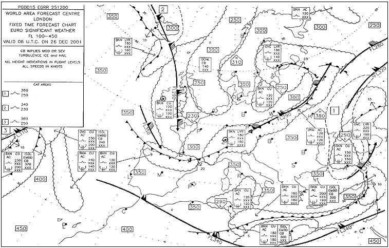
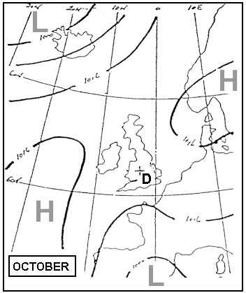
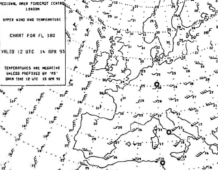
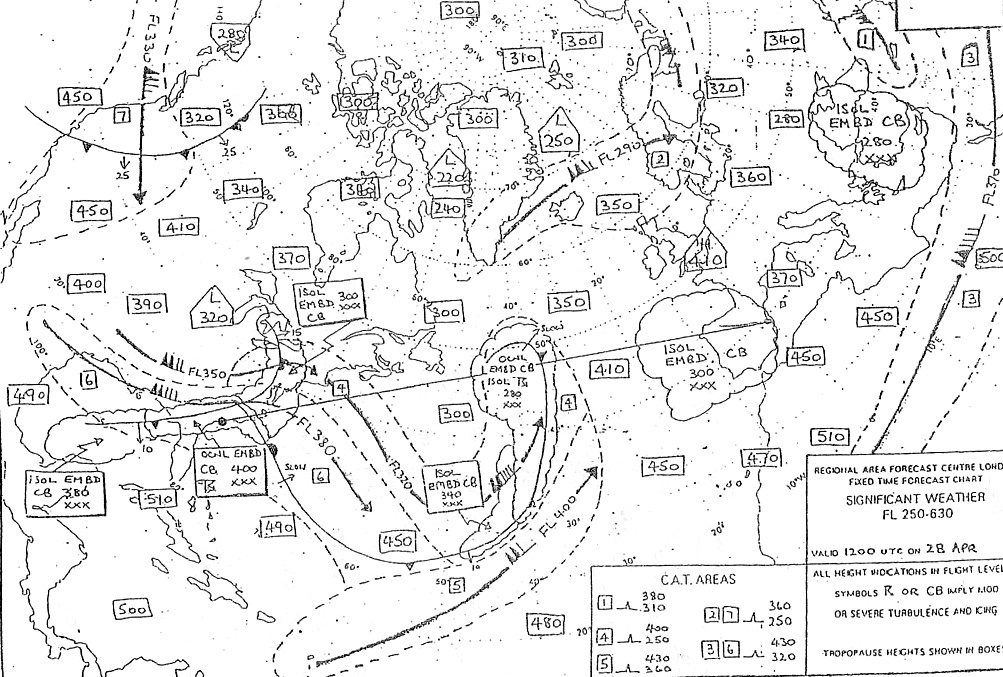
Question 183-24 : Which of these statements is true 396 ?
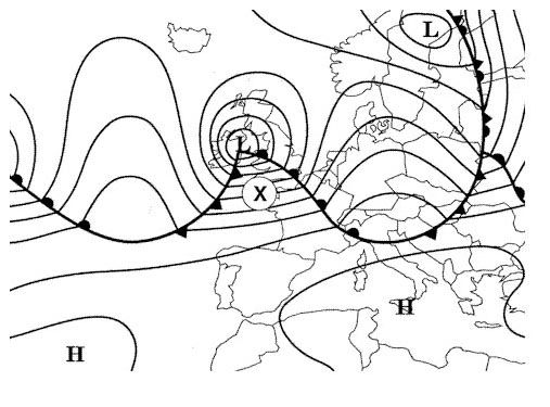
Local snow and severe aircraft icing can be expected over germany.
Ecqb03 august 2016Freezing level above london (egll) is higher than fl 65. turbulence is likely to be encountered at fl 400 over malaga (lemg). the front to the east of paris (lfpo) is moving south.
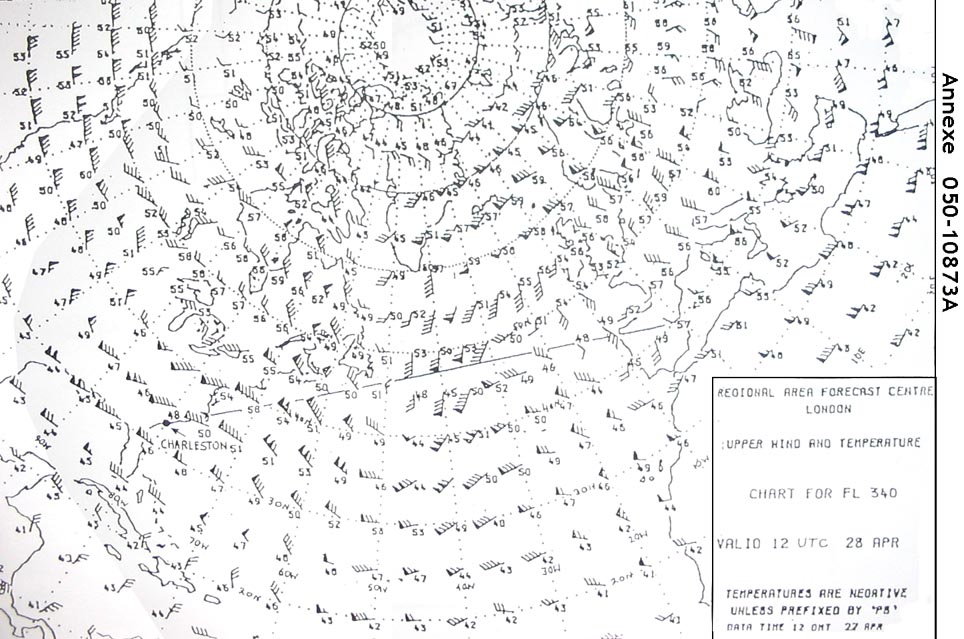
Question 183-25 : When the sky is overcast what means are used by meteorological services for measuring wind in any height between earth's surface and 10000 m ?
Radiosondes.
Ecqb03 august 2016Satellites. diffusionmeters. ceiling balloon and theodolite.
Question 183-26 : Which instrument is used for measuring atmospheric humidity ?
Psychrometer.
Eqcb03 december 2016psychrometer or hygrometerAnemometer. transmissometers. ceilometers.
Question 183-27 : The visibility transmitted in a metar is ?
The value that is reached or exceeded within at least half the horizon circle on the aerodrome.
The visibility transmitted in a metar is the visibility value that is reached or exceeded within at least half the horizon circle or within at least half of the surface of the aerodrome these areas could comprise contiguous or non contiguous sectorsGiven by transmissometer when the visibility is below 1500 metres. the lowest observed in a 360° scan from the meteorological station. b the maximum determined by a meteorologist in a 360° scan at the horizon.
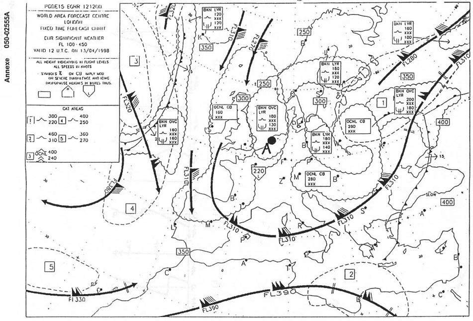
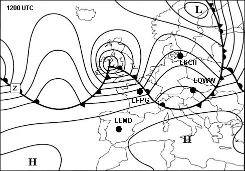
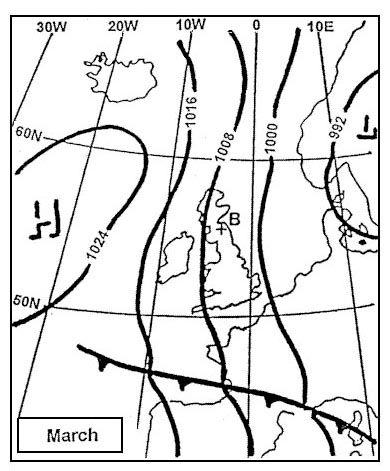
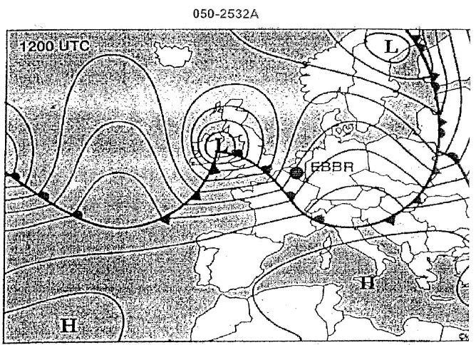
Question 183-28 : Which of the following metars reflect the weather conditions expected at brussels airport ebbr at 1200 utc 415 ?
Question 183-29 : Which of these statements about weather satellites are correct or incorrect 1 the pictures from satellites in a polar orbit are generally of higher resolution than the pictures from geostationary satellites2 satellites in a polar orbit are closer to the earth than geostationary satellites ?
1 is correct 2 is correct.
Polar orbiting satellites are close to the surface they provide higher resolution picturespolar orbiting satellites orbit the earth at an altitude of approximately 850 kmgeostationary satellites orbit the earth at about 36000 km of altitude over the equator1) is incorrect, 2) is correct. 1) is correct, 2) is incorrect. 1) is incorrect, 2) is incorrect.
Question 183-30 : The correct interpretation for the message below is mod ws rwy 16 fcst = ?
Wind shear between runway 16 level and and 1600 ft above that level.
Icao annex 374 wind shear warnings and alerts 741 wind shear warnings shall give concise information of the observed or expected existence of wind shear whichcould adversely affect aircraft on the approach path or take off path or during circling approach between runway level and 500 m 1 600 ft above that level and aircraft on the runway during the landing roll or take off run the warnings shall be prepared and disseminated for aerodromes where wind shear is considered a factor in accordance with local arrangements with the appropriate ats authority and operators concerned and by the meteorological office designated to provide service for the aerodrome or disseminated directly from automated ground based wind shear remote sensing or detection equipment referred to in 762 a and b where local topography has been shown to produce significant wind shears at heights in excess of 500 m 1 600 ft above runway level then 500 m 1 600 ft shall not be considered restrictiveWind shear between runway 16 level and and 2500 ft above that level. wind shear 1000 ft above runway 16 circling approach. wind shear 2000 ft above minimal altitude for runway 16 circling approach.
Question 183-31 : A meteorological briefing is ?
An oral commentary on existing andor expected meteorological conditions.
Printed documents constituting a flight record. an oral commentary on weather forecasts. careful reading of the meteorological elements available for the planned flight.
Question 183-32 : An aircraft encounters severe turbulence the pilot must ?
Issue a special air report message.
Issue a routine air-report message. issue a safety message. issue a report at destination.
Question 183-33 : The angle between the true great circle track and the true rhumb line track joining the following points a 60° s 165° w b 60° s 177° e at the place of departure a is ?
78°.
Change in longitude between a and b = 18° = 12 g sin lm = 12 x 18° x sin 60 = 9 x 0866 = 779°9°. 15.6°. 5.2°.
Question 183-34 : In order to fly from position a 10°00'n 030°00'w to position b 30°00'n 050°00'w maintaining a constant true course it is necessary to fly ?
A rhumb line track.
Rhumb lines or loxodromes are tracks of constant true coursegreat circle is the shortest distance between two points 1462The constant average drift route. the great-circle route. a straight line plotted on a lambert chart.
Question 183-35 : The rhumb line track between position a 45°00'n 010°00'w and position b 48°30'n 015°00'w is approximately ?
315°.
1360we have an isoceles trianglethe track between position a and position b will be approximately 270° + 45° = 315°345°. 330°. 300°.
Question 183-36 : The diameter of the earth is approximately ?
12 700 km.
6 350 km. 18 500 km. 40 000 km.
Question 183-37 : The maximum difference between geocentric and geodetic latitude occurs at about ?
45° north and south.
60° north and south. 90° north and south. 0° north and south (equator).
Question 183-38 : If an aéronef was to circle around the earth following parallel 60°n at a ground speed of 480 kt in order to circle around the earth along the equator in the same amount of time it should fly at a ground speed of ?
960 kt.
Distance around earth at 60ºn is 360° x 60 nm x cos60º = 10800 nmdistance around earth at the equator = 360° x 60 nm = 21600 nm10800 nm is half the distance of the circle around the equator so for the same time to cover twice the distance it should fly at a ground speed of 2 x 480 kt = 960 kt240 kt. 550 kt. 480 kt.
Question 183-39 : An aircraft passes position a 60°00'n 120°00'w on route to position b 60°00'n 140°30'w what is the great circle track on departure from a ?
279°.
Rhumb line or loxodrome route following a parallel or flying a constant latitude at constant true course from a to b is 270°conversion angle = 12 g sin lmconversion angle = 05 x 205 x sin 60° = 9°the great circle track on departure from a is 270° + 9° = 279°g = difference of longitudelm = mean latitude 1462for a westerly track in northern hemisphere a great circle track at departure is larger than the rhumb line288°. 261°. 270°.
Question 183-40 : A great circle track joins position a 59°s 141°w and b 61°s 148°w what is the difference between the great circle track at a and b ?
It increases by 6°.
1376the formula to calculate convergency between two positions relatively close to each other is convergency = difference of longitude x sin mean latitude convergency = 7° x sin60°convergengy = 7° x 0866 = 6°It decreases by 6°. it increases by 3°. it decreases by 3°.
Exclusive rights reserved. Reproduction prohibited under penalty of prosecution.