A free Premium account on the FCL.055 website! Read here
Sign up to unlock all our services and 15164 corrected and explained questions.
Question 189-1 : A ground feature was observed on a relative bearing of 315° and 3 minutes later on a relative bearing of 270° the wind is calmaircraft gs 180 ktthe minimum distance between the aircraft and the ground feature is ? [ Question security ]
9 nm
Question 189-2 : An island is observed to be 15° to the left the aircraft heading is 120° m variation 17° w the bearing ° t from the aircraft to the island is ?
088°.
Our magnetic heading is 120° magnetic variation is 17° west our true heading is 120° 17° = 103°true bearing of the island from the aircraft 103° 15°= 088°122°. 268°. 302°.
Question 189-3 : Lined up on runway 05 047° what should a direct reading compass must indicate ?
042° to 052°.
Amc 24 cs25cs 23 after correction the cumulative deviation on any heading should not exceed 10° 5° to the left and 5° to the right when lined up for take off you have to check if indication is within limits if you read 042° or 052° you are allowed to take offthis serviceability test consists of comparing the drc indication to another reference egother compass system or runway direction pdaus87 what is the true answer i do in aviation examit states the answer is 037 057 if you read 037° 057° accuracy is 20° and it's not correct and safe this question also exists with an other statement the maximum permissible deviation errors for a direct reading compass is right answer 10°045° to 049°. 037° to 057°. 032° to 062°.
Question 189-4 : Permanent magnetism in aircraft arises chiefly from ?
Hammering and the effect of the earth's magnetic field whilst under construction.
Exposure to the earth's magnetic field during normal operation the combined effect of aircraft electrical equipment and the earth's magnetic field the effect of internal wiring and exposure to electrical storms
Question 189-5 : The main reason for usually mounting the detector unit of a remote indicating compass in the wingtip of an aeroplane is to ?
Reduce the amount of deviation caused by aircraft magnetism and electrical circuits.
The detector unit is positioned in a part of the aircraft least affected by on board electrical fields usually the wing tip or tail fin where any aircraft generated magnetic disturbances are at a minimum Facilitate easy maintenance of the unit and increase its exposure to the earth's magnetic field. place it in a position where there is no electrical wiring to cause deviation errors. place it where it will not be subjected to electrical or magnetic interference from the aircraft.
Question 189-6 : Concerning direct reading magnetic compasses in the northern hemisphere it can be said that ?
On an easterly heading a longitudinal acceleration causes an apparent turn to the north.
Onus overshoot north undershoot southOn an easterly heading, a longitudinal acceleration causes an apparent turn to the south on a westerly heading, a longitudinal acceleration causes an apparent turn to the south on a westerly heading, a longitudinal deceleration causes an apparent turn to the north
Question 189-7 : A negative westerly magnetic variation signifies that ?
True north is east of magnetic north.
The minimum magnetic variation declination is 0° the maximum magnetic variation declination is 180°and this will be along a line between the magnetic north pole and the geographic north pole 1417a west magnetic variation declination signifies that true north is east of magnetic northTrue north is west of magnetic north. compass north is east of magnetic north. compass north is west of magnetic north.
Question 189-8 : In northern hemisphere during an acceleration in an easterly direction the magnetic compass will indicate ?
A decrease in heading.
Acceleration errors these are caused by inertia on east west headingsbecause the centre of gravity of the compasse is under the pivot point accelerating makes the bulk of the compass lag behind the machine and dispace the centre of gravity aft of the pivot point com encom061 350jpgif you were just going north south all you would get is extra dip but because you are going east or west the north bit of the compass is pointing to the side of the aircraft and the displaced centre of gravity not being vertically in line with the pivot point goes towards north to create a couple that makes the compass turn clockwise to read less than 90° during the turn a deceleration has the oppposite effect to the south in the northern hemisphere acceleration errors are maximum on eastwest headings and near the magnetic poles and nil on northsouth headings and at the equatorthe watchword here is ands for northern hemisphere accelerate north decelerate south or sand for southern hemisphere south accelerate north decelerate com encom061 77jpgexample in the northern hemisphere flying east if you accelerate the needle will deflect to the nearest pole north for an easterly deviation and to the south when decelerate during acceleration at take off on runway 18 for example a compass in the northern hemisphere would indicate no apparent turn during acceleraton at take off in an easterly direction a magnetic compass in the northern hemisphere indicates an apparent turn north during acceleraton at take off in an westerly direction a magnetic compass in the southern hemisphere indicates an apparent turn southAn increase in heading. an apparent turn to the south. a heading of east.
Question 189-9 : Magnetic compass calibration is carried out to reduce ?
Deviation.
Calibration means the measurement of the deviation of a compass installed in an aircraft'compass deviation' is the difference between magnetic north and the direction in which the compass is pointing deviation are measured in degrees east + or west causes of deviation the compass magnets is influenced by magnetic fields within the aircraft fuselage the electronic equipments the enginesVariation. parallax error. acceleration errors.
Question 189-10 : One purpose of a compass calibration is to reduce the difference if any between ?
Compass north and magnetic north.
Compass north and true north. true north and magnetic north. compass north and the lubber line.
Question 189-11 : One purpose of compass calibration is to determine the deviation ?
On any heading.
The deviation is accurately ascertained on a number of headings and a graph is drawn which enables us to find the deviation on any heading 2058then a deviation card is mounted near the compass showing the addition or subtraction required to correct for deviation on various headings usually at intervals of 30° 2057for intermediate readings the pilot should be able to interpolate mentally with sufficient accuracyOn a given heading. at any latitude. on n, s, e and w only.
Question 189-12 : The force acting on the needle of a direct reading compass varies ?
Directly with the horizontal component of the earth's magnetic field.
Magnetic dip is the angle between the horizontal and vertical forces acting on a compass needle toward the nearer pole com encom061 110jpgthe force acting on the compass needle is directly proportional to the horizontalcomponent of the earth's field and inversely proportional to the vertical component of the earth'sat the magnetic poles the earth's magnetic field is perpendicular to the earth's surface magnetic dip is 90° at the magnetic poles a dip needle stands vertical Directly with the vertical component of the earth's magnetic field. inversely with both vertical and horizontal components of the earth's magnetic field. inversely with the horizontal component of the earth's magnetic field.
Question 189-13 : If the compass heading is 265° variation is 33° w and deviation is 3°e what is the true heading ?
235°.
2055use this wonderful table for those questions229°. 301°. 295°.
Question 189-14 : In a remote indicating compass system the amount of deviation caused by aircraft magnetism and electrical circuits may be minimised by ?
Mounting the detector unit flux valve in the wingtip.
Mounting the flux valve in the cockpit. positioning the gyroscope in the centre of the aircraft. using a vertically mounted gyroscope instead of a horizontally mounted one.
Question 189-15 : Which of the following statements about hard and soft iron in relation to magnetism is correct ?
Hard iron magnetism is of a permanent nature and soft iron is of a non permanent nature.
Soft magnetic iron is a type of iron that has lower carbon content this type of soft magnetic iron is used to make electromagnets the low carbon content makes the iron more efficient at quickly getting magnetized and demagnetizedthe soft iron does not retain memory of magnetism that means there is no magnetism left in the soft iron as soon as the magnetic field is removed this is called low hysteresis loss in science this makes the soft iron best suitable for making electromagnetsa hard iron in contrast to soft iron retains the magnetism permanentlyBoth hard and soft iron are of a non-permanent nature. hard iron is is of a non-permanent nature and soft iron is of a permanent nature. both hard and soft hard iron are of a permanent nature.
Question 189-16 : Which of the following variables affect deviation 1 magnetic latitude2 aircraft heading3 aircraft altitude4 aircraft electronic equipment ?
1 2 and 4.
1, 2 and 3. 2 and 3. 3 and 4.
Question 189-17 : An ndb is located at position n55°26' w005°42' the variation at the ndb is 9°wthe position of the aircraft is 56°00'n 010°00'w the variation at the aircraft position is 11°wthe initial true track of the great circle from the aircraft position to the ndb position is 1015°what is the magnetic ?
1125°.
True track from the aircraft position to the ndb position is 1015°the variation at the aircraft position is 11°wmagnetic bearing of the ndb from the aircraft = 1015° + 11° = 1125° notice variation west magnetic best thus + for the variation108.5°. 110.5°. 114.5°.
Question 189-18 : Given compass heading = 233°true track = 256°drift angle = 10°rdeviation = 3°what is the variation ?
16°e.
com encom061 629jpguse this wonderful table for those questions20°w. 36°e. 10°w.
Question 189-19 : Deviation on the standby compass is ?
Dependent on the heading of the aircraft.
Independent of the latitude of the aircraft's position. zero on the magnetic equator. positive if the compass north is to the west of magnetic north.
Question 189-20 : Givent the deviation table of a direct reading compass drc the desired true heading is 155° the variation in the area is 10°wcourse 000 030 060 090 120 150 180 210 240 270 300 330steer 359 030 061 092 121 150 178 209 242 272 298 331what should be the indication of the direct reading compass drc ?
164°.
Desired true heading is 155° ==> magnetic heading to follow ==> compass heading to follow true heading 155° ==> magnetic heading 155° + 10° = 165° variation is 10°west so magnetic is best therefore our true heading is less than our magnetic heading the correction on the deviation table for 150° is 0°and for 180° is 2° at 165° halfway it will be 1°165° + 1° = 164°165°. 146°. 145°.
Question 189-21 : Direct reading compass drc deviation table is course 000 030 060 090 120 150 180 210 240 270 300 330steer 359 030 061 092 121 150 178 209 242 272 298 331direct reading compass indicates a heading 242°magnetic variation in this aera is 22°ethe true aircraft heading is ?
262°.
The heading reads on the instrument is a compass headingdeviation table gives for a compass heading of 242° a magnetic heading of 240°you now have to apply magnetic variation 22°e to find the true heading 240°+ 22° = 262°for information variation east magnetic least variation is 22°east so magnetic is least therefore our true heading is greater than our magnetic heading214°. 218°. 258°.
Question 189-22 : During pre flight check serviceability of a direct reading standby compass indication can be compared preferably with 1 runway direction during line up2 main compass indication3 test vor indication4 an adf bearing5 an airborne weather radar bearingthe combination regrouping all the correct ?
1 and 2.
1, 4 and 5. 1, 2, 3, 4 and 5. 1, 2 and 3.
Question 189-23 : Which statement is true about the direct reading compass drc ?
Before take off the drc should be checked by comparing the heading to runway direction.
The drc is serviceable when the indication during takeoff differs by not more than 2° from the runway true direction. the drc is serviceable when the indication is within 2° of the magnetic track on the navigation chart. the heading of the drc can only be checked with the runway direction after allowing for magnetic variation.
Question 189-24 : When an aircraft flies into the vicinity of one of the magnetic poles why does the magnetic compass becomes unreliable or even useless ?
The horizontal component becomes so weak that the directive force is insufficient for a reliable compass indication.
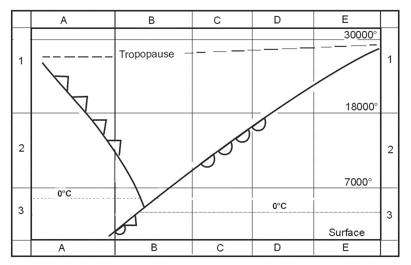
2031diagrammatic representation of the earth's magnetic field illustrating how field lines represented by arrows intersect the earth's surface and how inclination angle the angle formed between the field lines and the earth varies with latitude at the magnetic equator the curving line across the earth field lines are parallel to the earth's surface the field lines become progressively steeper as one travels north toward the magnetic pole where the field lines are directed straight down into the earth and the inclination angle is 90° near the magnetic pole the horizontal component of the earth's magnetic field is too small to permit the use of a magnetic compass The magnetic inclination angle is minimal and the needle of a compass in free mode will be aligned vertically. the vertical component becomes so weak that the directive force is insufficient for a reliable compass indication. the magnetic inclination angle is maximal and the needle of a compass in free mode will be aligned horizontally.
Question 189-25 : A significant amount of ferrous material is transported on a cargo flight which aircraft system s should be checked for accuracy ?
The direct reading magnetic compass drmc .
The automatic direction-finding equipment (adf). the inertial reference systems (irs). all gyroscopic flight instruments.
Question 189-26 : According to the certification specifications for large aeroplanes cs 25 for standby compass instruments the accuracy of the magnetic heading indications after correction should be better than or equal to ?
10°.
cs 251327 direction indicator b the magnetic direction indicator required by cs 251303 a 3 may not have a deviation after compensation in normal level flight greater than 10 degrees on any headingan accuracy of 10° or better is when readings are 042° 052° when line up on runway 05 for exampleif you read 037° 057° accuracy is 20° and it's not correct this question also exists with the statement the maximum permissible deviation errors for a direct reading compass is answer 10°1°. 5°. 3°.
Question 189-27 : Which of the following will probably not result in a deviation change on a drc ?
Turning the adf on in flight.
Ecq06 august 2020Relocating a steel iron construction in the cargo compartment close to the drc. a walk-man headset placed close to the compass. letting a passenger in the cockpit jump-seat put his mobile phone next to the drc.
Question 189-28 : An aircraft is lined up on runway 23 which is aligned with a magnetic bearing of 232°m during pre flight checks it is observed that the direct reading magnetic compass reads 243°m what action should be taken by the flight crew in order to comply with maximum permissible deviation errors ?
Cancel the flight and return to maintenance.
Ecqb06 august 2020maximum permissible deviation errors are + 10° error given is 11° in this case the crew must cancel the flight and go to maintenanceAdjust the compass by -11° prior to commencing the take-off roll. continue the flight with no adjustments required. adjust the compass by +11° prior to commencing the take-off roll.
Question 189-29 : Annex ecqb 061 002 v2015 09deviation for a compass heading of 088° is 2483 ?
2°.
2°e. 2°w. 0°.
Question 189-30 : The magnetic compass shows ?
Compass heading.
Magnetic heading. magnetic track. compass track.
Question 189-31 : A direct reading compass drc ?
Does not require power from the aircraft systems to indicate the direction.
Is unaffected by interference from other aircraft components and systems. is only certified for vfr flights and during published hours of daylight. is more reliable than a gyroscopic directional compass during turns, and accelerations or decelerations.
Question 189-32 : An aircraft is lined up on runway 24 which is aligned with a magnetic bearing of 242°m in order to comply with maximum permissible deviation errors the direct reading magnetic compass readings should be between ?
237° 247°.
Ae indique + 10° moi 5° seulement ce qui est plus logique j'ai volontairement enlevé la proposition 232° 252° ecqb06 august 2020 cs 251327 direction indicator b the magnetic direction indicator required by cs 251303 a 3 may not have a deviation after compensation in normal level flight greater than 10 degrees on any headingan accuracy of 10° or better is when readings are 042° 052° when line up on runway 05 for exampleif you read 037° 057° accuracy is 20° and it's not correct this question also exists with the statement the maximum permissible deviation errors for a direct reading compass is answer 10°240°-250°. 235°-245°. 239°-245°.
Question 189-33 : Your magnetic compass shows a compass heading of 090° 'e' what is your magnetic heading if the deviation is 3° ?
087° m .
093°(m). 096°(m). 090°(m).
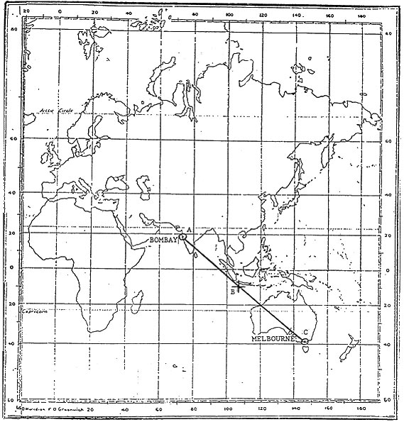
Question 189-34 : Position a is located on the equator at longitude 130°00e position b is located 100 nm from a on a bearing of 225° t the coordinates of position b are ?
01°11's 128°49'e.
Position b is on a bearing of 225° south west from a if you departe from a located on the equator you will go in the south hemisphere so answer with 01°11 n are wrongyou are going west longitude will be less than 130°est01°11'n 131°11'e. 01°11's 131°11'e. 01°11'n 128°49'e.
Question 189-35 : The nominal scale of a lambert conformal conic chart is the ?
Scale at the standard parallels.
The lambert conformal is what most of today's aeronautical charts are based on 1776on a lamberts chart scale is correct at the standard parallels where the cones slices through the surface of the globe and convergency is correct along the parallel of origin and the constant of the cone or convergence factor is the sine of the parallel of originMean scale between pole and equator mean scale between the parallels of the secant cone scale at the equator
Question 189-36 : The chart that is generally used for navigation in polar areas is based on a ?
Stereographical projection.
The azimuthal stereographic projection is a conformal projection since the projection is conformal parallels and meridians intersect at right angles in the polar aspect the meridians are equally spaced straight lines the parallels are unequally spaced circles centered at the pole 1383spacing gradually increases away from the pole the scale is constant along any circle having its centre at the projection centre but increases moderately with distance from the centre the ellipses of distortion remain circles indicating conformality areas increase with distance from the projection center the polar stereographic projection is used in combination with the utm coordinate system as universal polar stereographic ups for mapping regions north of 84°n and south of 80°s polar areas recommended for conformal mapping of regions approximately circular in shapeDirect mercator projection. gnomonic projection. lambert conformal projection.
Question 189-37 : A mercator chart has a scale at the equator = 1 3 704 000 what is the scale at latitude 60° s ?
1 1 852 000.
At 60°s scale is = 1 3 704 000 x 1 cos60°scale = 1 3 704 000 x 1 05scale = 1 3 704 000 x 05 scale = 1 1 852 0001: 7 408 000 1: 3 208 000 1: 185 200
Question 189-38 : The distance measured between two points on a navigation map is 42 mm millimetres the scale of the chart is 1 1 600 000 the actual distance between these two point is approximately ?
3630 nm.
1 mm on the map = 1 600 000 mm on the ground1 600 000 mm = 16 km16 km 1852 = 0864 nm1 mm on the map = 0864 nm on the ground42 mm = 0864 x 42 = 3628 nm370.00 nm. 67.20 nm. 3.69 nm.
Question 189-39 : The standard parallels of a lambert's conical orthomorphic projection are 07°40'n and 38°20'n the constant of the cone for this chart is ?
039.
Constant of cone convergency factor the ratio between the top angle of the unfolded cone and 360° or sine of the parallel of originthe parallel of origin is about half way between the standard parallels midway between 07°40'n and 38°20'n is 23°sin of 23° = 0390.6 0.92 0.42
Question 189-40 : On a lambert conformal conic chart the convergence of the meridians ?
Is the same as earth convergency at the parallel of origin.
On a lamberts chart scale is correct at the standard parallels where the cones slices through the surface of the globe and convergency is correct along the parallel of origin and the constant of the cone or convergence factor is the sine of the parallel of originIs zero throughout the chart. varies as the secant of the latitude. equals earth convergency at the standard parallels.
Exclusive rights reserved. Reproduction prohibited under penalty of prosecution.