A free Premium account on the FCL.055 website! Read here
Sign up to unlock all our services and 15164 corrected and explained questions.
Question 192-1 : Given sha vordme n52433 w008531 radial 025°49 nm what is the aircraft position err a 061 431 ? [ Level reports ]
N5330 w00830
Question 192-2 : Given sha vor n52433 w008531 crk vor n51504 w008297 aircraft position n5220 w00910which of the following lists two radials that are applicable to the aircraft position err a 061 433 ?
Sha 214° crk 330°.
Plot position n5220 w00910 and draw two lines one from sha vor and one from crk vor com encom061 433jpguse the magnetic north tick from vor's magnetic north is indicated over vors and ndbs and use your protractor to find sha 214° crk 330°Sha 033° crk 149°. sha 205° crk 321°. sha 025° crk 141°.
Question 192-3 : Given sha vor n52433 w008531 crk vor n51504 w008297 aircraft position n5230 w00930 which of the following lists two radials that are applicable to the aircraft position err a 061 435 ?
Question 192-4 : Given sha vor n52433 w008531 con vor n53548 w008491 aircraft position n5320 w00950which of the following lists two radials that are applicable to the aircraft position err a 061 437 ?
Sha 325° con 235°.
com encom061 437jpgmagnetic north is indicated over vors and ndbsSha 137° con 046° sha 317° con 226° sha 145° con 055°
Question 192-5 : Given sha vor n52433 w008531 dme 41 nm crk vor n51504 w008297 dme 30 nm aircraft heading 270° m both dme distances decreasing what is the aircraft position err a 061 439 ?
N5215 w00805.
com encom061 439jpgyou draw two circles use the vertical scale to define the distances both dme distances decreasing so this is the only valid junction positionN5205 w00915 n5215 w00915 n5225 w00810
Question 192-6 : Given crn vor n53181 w008565 dme 34 nm sha vor n52433 w008531 dme 26 nm aircraft heading 090° m both dme distances increasingwhat is the aircraft position err a 061 441 ?
N5255 w00815.
com encom061 441jpgN5250 w0030. n5305 w00930. n5310 w00820.
Question 192-7 : Given crk vordme n51504 w008297 kerry aerodrome n52109 w009314 what is the crk radial and dme distance when overhead kerry aerodrome err a 061 443 ?
Question 192-8 : Given sha vordme n52433 w008531 connemara aerodrome n5314 w00928 what is the sha radial and dme distance when overhead connemara aerodrome err a 061 445 ?
333° 37 nm.
Jaibasi connemara = 532333°n 94666°wsha = 527216°n 8885°wdistance between connemara and sha on latitude = 532333 527216 = 0511705117 * 60 = 30702 nmsin x =30702hypotenuse = 3070237 = 08297837838x=asin 08297837838 = 560765°we are in the fourth quadrant then sha radial = 270 + 560765 = 3260765°i did with the rule on the screem trying to plot but same result as 326°do not forget to apply the magnetic variation around 8°w at sha vordme since we are looking for a radial departing from sha variation is applied at the vor 'variation west magnetic best' 326° + 8°w = 334°use the magnetic north tick from sha vor center your protractor you read a radial of 333° com encom061 445jpguse the scale to find the distance 37 nm154° - 38 nm 326° - 37 nm 146° - 38 nm
Question 192-9 : Given con vordme n53548 w008491 abbey shrule aerodrome n5335 w00739 what is the con radial and dme distance when overhead abbey shrule aerodrome err a 061 447 ?
123° 46 nm.
com encom061 447jpguse the vertical scale to find the distance magnetic north is indicated over vors and ndbs304° - 47 nm 296° - 46 nm 116° - 47 nm
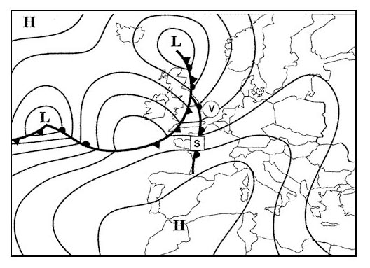
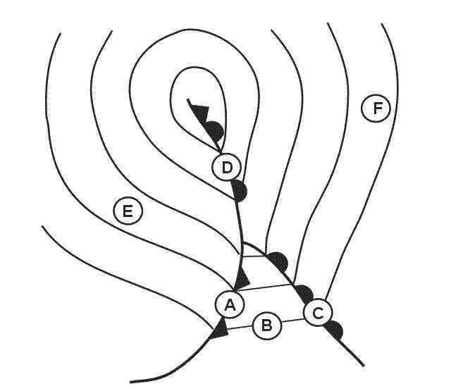
Question 192-10 : What feature is shown on the chart at position n5211 w00931 err a 061 448 ?
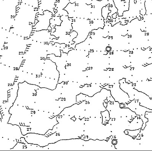
Question 192-15 : Which of the following lists all the aeronautical chart symbols shown at position n51504 w008297 err a 061 453 ?
Civil airport vor dme compulsory reporting point.
com encom061 453ajpg com encom061 453jpgVor; dme; ndb; ils. vor; dme; ndb:compulsory reporting point. civil airport; vor; non-compulsory reporting point.
Question 192-16 : Which of the following lists all the aeronautical chart symbols shown at position n53180 w006269 err a 061 454 ?
Military airport vor dme.
com encom061 454jpg'ab'for 'air base'vor bal is dme capable indicates by 'd' before the frequency Civil airport, vor, dme. military airport, vor, ndb. vor, dme, danger area.
Question 192-17 : Which of the following lists all the aeronautical chart symbols shown at position n54167 w008360 err a 061 455 ?
Civil airport ndb dme compulsory reporting point.
com encom061 455jpgndb slg frequency 384 khzdme tacan slg frequency 10900 mhz com encom061 453jpgVor; dme; ndb; compulsory reporting point. civil airport; vor; dme; non-compulsory reporting point. vor; dme; ndb; non-compulsory reporting point.
Question 192-18 : Which of the following lists all the aeronautical chart symbols shown at position n53181 w008565 err a 061 456 ?
Civil airport ndb dme non compulsory reporting point.
com encom061 456jpgndb crn frequency 321 khzdme tacan crn frequency 11000 mhz com encom061 453jpgVor; dme; ndb; compulsory reporting point. civil airport; vor; dme; non-compulsory reporting point. vor; dme; ndb; compulsory reporting point.
Question 192-19 : Which of the following lists all the aeronautical chart symbols shown at position n5211 w00705 err a 061 457 ?
Civil airport ndb.
com encom061 457jpgCivil airport: ils ndb: ils vor: ndb
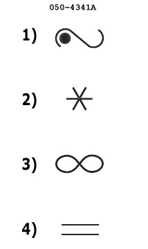
Question 192-20 : Which of the aeronautical chart symbols indicates a vordme 2513 ?
5.
25127. 6. 2.
Question 192-21 : Which of the aeronautical chart symbols indicates a dme 2513 ?
4.
25126. 3. 5.
Question 192-22 : Which of the aeronautical chart symbols indicates a vor 2513 ?
3.
25125. 6. 2.
Question 192-23 : Which of the aeronautical chart symbols indicates an ndb 2513 ?
2.
25123. 4. 6.
Question 192-24 : Which of the aeronautical chart symbols indicates a basic non specified navigation aid 2513 ?
1.
25126. 2. 3.
Question 192-25 : Which of the aeronautical chart symbols indicates a tacan 2513 ?
6.
25127 1 2
Question 192-26 : Which of the aeronautical chart symbols indicates a vortac 2513 ?
7.
25121. 3. 6.
Question 192-27 : Which aeronautical chart symbol indicates a flight information region fir boundary 2509 ?
1.
25103 4 5
Question 192-28 : Which aeronautical chart symbol indicates a control zone boundary 2509 ?
2.
25103. 4. 5.
Question 192-29 : Which aeronautical chart symbol indicates an uncontrolled route 2509 ?
4.
25105 2 3
Question 192-30 : Which aeronautical chart symbol indicates the boundary of advisory airspace 2509 ?
5.
25102 3 4
Question 192-31 : Which aeronautical chart symbol indicates a non compulsory reporting point 2509 ?
6.
25108. 7. 15.
Question 192-32 : Which aeronautical chart symbol indicates a compulsory reporting point 2509 ?
7.
25108. 6. 15.
Question 192-33 : Which aeronautical chart symbol indicates a waypoint 2509 ?
8.
25105. 6. 7.
Question 192-34 : Which aeronautical chart symbol indicates an unlighted obstacle 2509 ?
9.
251210. 11. 12.
Question 192-35 : Which aeronautical chart symbol indicates a lighted obstacle 2509 ?
10.
25129. 11. 12.
Question 192-36 : Which aeronautical chart symbol indicates a group of unlighted obstacles 2509 ?
11.
25129. 12. 13.
Question 192-37 : Which aeronautical chart symbol indicates a group of lighted obstacles 2509 ?
12.
25129. 10. 11.
Question 192-38 : Which aeronautical chart symbol indicates an exceptionally high unlighted obstacle 2509 ?
13.
251211. 10. 9.
Question 192-39 : Which aeronautical chart symbol indicates an exceptionally high lighted obstacle 2509 ?
14.
251210. 12. 13.
Question 192-40 : What is the meaning of aeronautical chart symbol n°15 2509 ?
Aeronautical ground light.
2512Visual reference point. hazard to aerial navigation. lighthouse.
Exclusive rights reserved. Reproduction prohibited under penalty of prosecution.