A free Premium account on the FCL.055 website! Read here
Sign up to unlock all our services and 15164 corrected and explained questions.
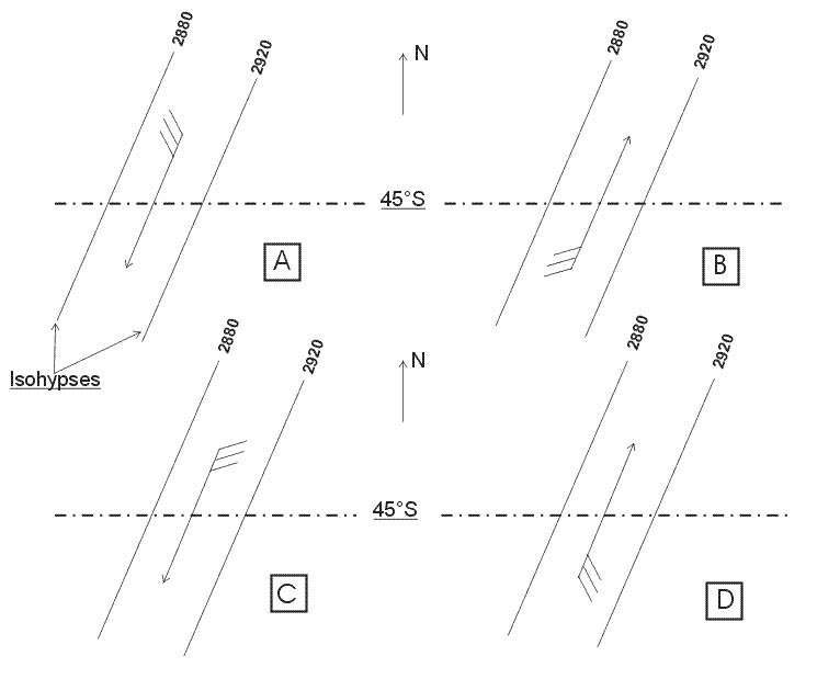
Question 210-1 : An aircraft is flying on the 170 radial with a magnetic heading of 315°on the cdi the crs is set to 180which cdi shows the correct indications err a 062 478 ? [ Preparation civilian ]
Figure d
Question 210-2 : An aircraft is flying on a magnetic heading of 210°the magnetic variation at the vor is 5°w and at the aircraft 10°wwhich vor rmi corresponds to the indications on the cdi shown on the annex err a 062 479 ?
Figure d.
com encom062 479jpgwhat is the magnetic bearing given by the cdi we are 5° left of our intended radial which is qdm200° radial 020° we are on radial 025° the pointer of figure d rmi shown a 205° magnetic bearing to the station radial 025° inbound Figure a. figure b. figure c.
Question 210-3 : An aircraft is flying on a magnetic heading of 010°the magnetic variation at the vor is 10°w and at the aircraft 12°wwhich vor rmi corresponds to the indications on the cdi shown on the annex 2080 ?
Figure d.
2596the cdi shows a selected course crs of 060° indication is to and we need to turn right to join the selected radial we do not have yet passed the vor we are currently on radial 250°Figure a. figure b. figure c.
Question 210-4 : An aircraft is flying on the 245° radial with a magnetic heading of 250°on the hsi the crs is set to 060°which hsi shows the correct indications 2078 ?
Figure a.
2597our aircraft is flying on the 245° radial with 'to' indication on the hsicrs is set to 060° that means radial 240° inboundFigure b. figure c. figure d.
Question 210-5 : An aircraft is flying on a magnetic heading of 010°the magnetic variation at the vor is 10°w and at the aircraft 12°wwhich vor rmi corresponds to the indications on the cdi shown on the annex err a 062 482 ?
Figure a.
com encom062 482jpgFigure b. figure c. figure d.
Question 210-6 : An aircraft is flying on the 050° radial with a mh of 250°on the hsi the crs is set to 060° which hsi shows the correct indications 2077 ?
Figure b.
2598Figure c. figure d. figure a.
Question 210-7 : An aircraft is flying on a magnetic heading of 210°the magnetic variation at the vor is 5°w and at the aircraft 10°wwhich vor rmi corresponds to the indications on the hsi shown on the annex err a 062 484 ?
Figure b.
com encom062 484jpgthe cdi shows a selected course crs of 200° indication is to and we need to turn right to join the selected radial needle deviation is at half of his maximum position 5° right of our selected course we do not have yet passed the vor we are currently on radial 025° inbound the vor our rmi shows the direction of the station 025° + 180° = 205°Figure c. figure d. figure a.
Question 210-8 : An aircraft is flying on a magnetic heading of 010°the magnetic variation at the vor is 10°w and at the aircraft 12°wwhich vor rmi corresponds to the indications on the hsi shown on the annex err a 062 485 ?
Figure b.
We have already crossed the radial 240° inbound the black arrow of the hsi shows 060° this is qdm 060 radial 240° inbound for figure a vor rmi needle shown the direction of the station on a magnetic heading of 050° so it can not be the correct answerfor figure b vor rmi needle shows the direction of the station on a magnetic heading of 070° it could be a right answer because we already have crossed the radial 250° inbound qdm 070° for figure c vor rmi needle shows the direction of the station on a magnetic heading of 250° and on our hsi we have the 'to' indication meaning the station is in front of us so it's not possiblefor figure d same as figure cso only one correct answer figure blet's have a quick look on the situation com encom062 485jpgfor training purpose please use one of the following websites navigation simulatoradf vor simulatorvor simulatorluizmonteiro learning vorFigure c. figure d. figure a.
Question 210-9 : An aircraft is flying on the 050 radial with a magnetic heading of 250°on the cdi course deviation indicator the crs course is set to 060which cdi shows the correct indications err a 062 486 ?
Figure c.
com encom062 486jpgwe are on the radial 050° it means that we are on the right of radial 060° and if the aircraft's radial is on the same side of the vor as the selected course 'from' is indicatedFigure d. figure a. figure b.
Question 210-10 : An aircraft is flying on the 170° radial with a magnetic heading of 315°on the hsi the crs is set to 180°which hsi shows the correct indications 2073 ?
Figure c.
2599we are on the radial 170° it means that we didn't yet cross the radial 180°Figure b. figure a. figure d.
Question 210-11 : An aircraft is flying on a magnetic heading of 010°the magnetic variation at the vor is 10°w and at the aircraft 12°wwhich vor rmi corresponds to the indications on the hsi shown on the annex err a 062 488 ?
Figure c.
com encom062 488jpgthe cdi shows a selected course crs of 060° indication is 'from' we are 5° before the radial 060° half needle deviation = 5° we are on radial 065° opposite radial is 065° + 180° = 245°vor rmi needle from figure c shows a station direction of 245°Figure d. figure a. figure b.
Question 210-12 : Locators are ?
Lfmf ndbs used as an aid for final approach.
High powered ndbs used for en route and airways navigation. beacons with a range of 10 to 250 nm. low powered adfs used for airfield or runway approach.
Question 210-13 : The uhf band is the assigned frequency band of the ?
Ils glide path transmitter.
Vor operating frequencies vhflocaliser vhfmarker beacon vhfdme operating frequencies uhfglide slope uhfgnssgps uhfl1 and l2 frequencies used by navstargps uhfils localiser and glide slope vhf and uhf bandsmicrowave landing system mls shfairborne weather radars shflocator lfmfIls localiser transmitter. outer marker beacon. all the 3 ils marker beacons.
Question 210-14 : Performing an ils approach you will fly overhead the markers in an specific order this order is ?
Om mm im if available .
Im (if available), mm, om. om, im (if available), mm. mm, im (if available), om.
Question 210-15 : The ident of a dme in case of collocation with a vor is as follows ?
In 40 seconds the dme ident will sound once.
When identifying a dme station co located with a vor station the identification signal with the higher tone frequency is the dme which idents approximately every 40 seconds 4 times in 30 seconds 10 seconds broadcast off in a period of 40 seconds the dme ident will be heard once on an audio frequency of 1350 hzIn 30 seconds the dme ident comes up 3 times at an audio frequency of 1350 hz. in case of collocation the dme ident is not necessary if the vor ident is present. the dme ident comes up every 10 seconds at an audio frequency of 1020 hz.
Question 210-16 : A vdf may be used ?
To provide the atc controller with bearings of aircraft in the absence of radar.
A vdf vhf direction finding provides a means of determining the aircraft bearing from a ground station with a vdf atc controller are capable of measuring the direction of arrival of radio transmissions from aircraft in the absence of radarIn lieu of ils for precision approach purposes. in combination with radar to solve the 180° ambiguity. in emergency type situations when the aircraft is unable to transmit on vhf.
Question 210-17 : The mls frequencies and available channels are ?
In the shf band 300 khz frequency separation giving 200 available channels.
Vor operating frequencies vhflocaliser vhfmarker beacon vhfdme operating frequencies uhfglide slope uhfgnssgps uhfl1 and l2 frequencies used by navstargps uhfils localiser and glide slope vhf and uhf bandsmicrowave landing system mls shfairborne weather radars shflocator lfmfIn the range 5060 - 5090 mhz, 200 khz separation giving 150 available channels. in the vhf and uhf band, 40 available channels. in the shf band for the mls elements and the vhf band for the dme, 100 available channels.
Question 210-18 : If the angular displacement of an aircraft with respect to the localiser centerline doubles eg from 1° to 2° the measured difference in depth of modulation ?
Doubles.
The difference in the modulation depth increases with displacement from the centre lineon each side of the localiser centerline the ddm increases in a linear fashion up to at least 3° on both sides of the runwayIncreases fourfold. is halved. remains unchanged.
Question 210-19 : Concerning the localiser principle of operation in an ils system the difference in depth of modulation ddm ?
Increases linearly with respect to the angular displacement from the centerline.
The difference in depth of both the signals will increase the further away a greater angular displacement from the centre line the aircraft isthis increase is linearlocalizer top view com encom062 503jpgIncreases linearly with respect to the distance from the centre line. decreases proportionally to the angular displacement from the centerline. decreases with respect to the angular displacement from the centerline.
Question 210-20 : The ils marker identified visually by an blue flashing light is the ?
Outer marker.
Inner marker. middle marker. locator.
Question 210-21 : The ils marker identified audibly by a series of two dashes per second is the ?
Outer marker.
Inner marker. middle marker. locator.
Question 210-22 : The ils marker with an aural frequency of 400 hz is ?
Question 210-23 : An ils marker beacon operates in the ?
Vhf band.
Vor operating frequencies vhflocaliser vhfmarker beacon vhfdme operating frequencies uhfglide slope uhfgnssgps uhfl1 and l2 frequencies used by navstargps uhfils localiser and glide slope vhf and uhf bandsmicrowave landing system mls shfairborne weather radars shflocator lfmfLf/mf band. hf band. uhf band.
Question 210-24 : Which answer states the typical distances along the centerline of the runway of the various ils components ?
Localizer transmitter 300 meter behind end of runway glide path transmitter 300 meter behind threshold middle marker 1000 meter from threshold outer marker 4 nm from threshold.
Localizer transmitter:100 meter behind end of runway, glide path transmitter: 100 meter behind threshold, middle marker: 1.5 nm from threshold, outer marker:10 nm from threshold. localizer transmitter: 100 meter behind end of runway, glide path transmitter: 300 meter behind threshold, middle marker: 1000 meter from threshold, outer marker: 4 nm from threshold. localizer transmitter: 300 meter behind end of runway, glide path transmitter: 300 meter behind threshold, middle marker: 1.5 nm from threshold, outer marker:10 nm from threshold.
Question 210-25 : The ils marker identified audibly by a series of alternate dots and dashes is the ?
Middle marker.
Locator. outer marker. inner marker.
Question 210-26 : The ils marker with an aural frequency of 1300 hz is the ?
Middle marker.
Locator. inner marker. outer marker.
Question 210-27 : The adf indication in the cockpit is a ?
Relative bearing on a fixed card indicator.
The bearing indicator displays the bearing to the station relative to the nose of the aircraft if the pilot is flying directly to the station the bearing indicator points to 0° an adf with a fixed card bearing indicator always represents the nose of the aircraft as 0° and the tail as 180° com encom062 16472jpgMagnetic bearing on a fixed card indicator. true bearing on an rmi. relative bearing on an rmi.
Question 210-28 : Concerning adf and ndb ?
Ndb is a ground equipment and adf is an airbone equipment.
Ndb is a locator and adf is an en route nav-aid. adf is a civilian equipment whereas ndb is a military equipment used by civilians too. adf is an ground equipment and ndb can be a ground equipment or an airbone equipment.
Question 210-29 : The ils receiver of an aircraft flying down the exact runway centreline will receive ?
90 hz and 150 hz lobes at equal depth.
'flying down' means 'flying along' the ils glide path not below the glide pathNo modulated signal because the left and the right lobes cancel each other along the centerline. the maximum magnitude of the difference between the 90 hz and 150 hz amplitudes. the same frequency modulated signal from both lobes with the maximum of magnitude.
Question 210-30 : The ils receiver of an aircraft on approach and flying on the glidepath will receive ?
The modulation from both lobes at equal depth.
Radiation pattern are 90 hz and 150 hz signals com encom062 12691jpgdistribution of the frequencies seen in the approach direction com encom062 15293jpgif the aircraft is exactly on the glidepath on the exact runway centreline it receives a balance between modulationsNo modulated signal because the two lobes cancel each other along the centerline. the maximum magnitude of the difference between the two amplitudes. the same modulation frequency signals from both lobes with the maximum of magnitude.
Question 210-31 : Ndb is the abbreviation for ?
Non directional beacon.
One of the older types of radio navigation is the automatic direction finder adf or non directional beacon ndb the adf receiver a 'backup' system for the vhf equipment can be used when line of sight transmission becomes unreliable or when there is no vor equipment on the ground or in the aircraftit is used as a means of identifying positions receiving low and medium frequency voice communications homing tracking and for navigation on instrument approach proceduresNon directional bearing. navigation director beacon. night directional beacon.
Question 210-32 : The ils marker identified visually by an white light flashing is the ?
Inner marker.
Outer marker. middle marker. locator.
Question 210-33 : The ils marker identified visually by an amber light flashing is the ?
Middle marker.
Outer marker. inner marker. locator.
Question 210-34 : On an rmi the front end of a vor pointer indicates the ?
Radial plus 180°.
2600the front end the head or the arrow of a vor pointer indicates the vor direction the radials of a vor always point away from the station thus we are on the radial 257°the end of the pointer shows the radialthe arrow shows the radial + or 180°Radial. magnetic bearing to the station. magnetic bearing from the station.
Question 210-35 : What is the effect of multipath signals coming from the same aircraft at the ground vhf direction finder station ?
They may result in bearing errors.
2601Regardless the difference in distance travelled by these signals, it results in their extinction of the signals at the ground vhf direction finder station. it reduces the range at which the ground vhf direction finder station receives signals from the aircraft. it may result in an increase of the distance at which the ground vhf direction finder station receives signals from the aircraft, if the ground station is situated in the skipzone.
Question 210-36 : One of the possible disturbances of the ils signal is 'scalloping'which statement is correct ?
Scalloping causes rapid indicator changes from side to side of the intended approach path which can not be followed by the aircraft.
Normally the ils signal gives you a 'straight line' down to the threshold you may experience some interference with this signal resulting in a 'bent' signal if you follow the localiserglideslope indications the path follows a sine curve all the way down to the runway thus it oscillates above and below the normal slope this oscillation is irregular and can not be followed by the aircraftScalloping are major changes or bends in the approach path which can not be followed by the aircraft. scalloping are minor changes or bends which can be followed by the aircraft. scalloping are rapid changes or bends which can be followed by the aircraft.
Question 210-37 : Which of the following statements about the scalloping path deflection of vor radials in relation to the accuracy of navigation using a vordme rnav system is correct ?
Scalloping has a negative effect on the accuracy of navigation.
Scalloping has a positive effect on the accuracy of navigation. scalloping has no effect on the accuracy of navigation because it only results in the movement of the needle of the course deviation indicator. scalloping has no effect on the accuracy of navigation because this accuracy is independent of vor or dme-measurements.
Question 210-38 : In flight a pilot can improve the range of his transmission with a vdf operator by ?
Increasing altitude.
Speaking louder. flying out of clouds. decreasing altitude.
Question 210-39 : The uhf band is assigned to the 1 locator2 localiser3 outer marker4 glide paththe combination that regroups all the corrects statements is ?
4.
Vor operating frequencies vhflocaliser vhfmarker beacon vhfdme operating frequencies uhfglide slope uhfgnssgps uhfl1 and l2 frequencies used by navstargps uhfils localiser and glide slope vhf and uhf bandsmicrowave landing system mls shfairborne weather radars shflocator lfmf1 and 3. 3 and 4. 1.
Question 210-40 : Tvor is a ?
Vor with a limited range used in the terminal area.
Tvor terminal vorthe range of 108 to 112 mhz is allocated for terminal vor terminal vors are accurate to 25 nm outward up to 12000 ft tvor is not a 'vot' which is a 'test vor' Test vor transmitting such a signal that the reference signal and variable signal are always in phase. high power vor in the frequency range 108 mhz - 112 mhz. low power dvor in the frequency range 112 mhz - 118 mhz.
Exclusive rights reserved. Reproduction prohibited under penalty of prosecution.