A free Premium account on the FCL.055 website! Read here
Sign up to unlock all our services and 15164 corrected and explained questions.
Question 220-1 : An antenna is defined as a ? [ Certification weather ]
Wave type transducer for the process of converting a line ac into a free electromagnetic wave
Question 220-2 : Ssr transponderwhat is involved in enhanced downlink tas ground speed eas magnetic heading course flight level ?
Tas ground speed magnetic heading.
Ecqb04 november 2017enhanced mode s surveillance consists of the extraction of additional aircraft parameters known as downlink aircraft parameters dap consisting of magnetic heading indicated airspeed mach number vertical rate roll angle track angle rate true track angle ground speed selected altitudenote tas is provided if track angle rate is not availableTas, eas, flight level. ground speed, magnetic heading, course. eas, course, flight level.
Question 220-3 : Ssr transpondera mode s surveillance protocols implicitly use the principle of selective addressing the advantage of mode s for a ssr over a primary radar is ?
It permits unambiguous aircraft identification.
Ecqb04 november 2017The range does not depend on transmitter power. there is no interaction with the air or space segment. in the event of an ssr failure, it can act as a primary radar.
Question 220-4 : A vertical aerial antenna needs the receiver to be oriented in the plane to receive the em wave in the plane ?
Vertical vertical.
Ecqb04 november 2017an electromagnetic wave em consists of an oscillating electric field e and an oscillating magnetic field h which propagates at the speed of lightthe electric field is parallel to the wire and the magnetic field is perpendicular to itthe e and h fields are perpendicular to each otherHorizontal, vertical. horizontal, horizontal. vertical, horizontal.
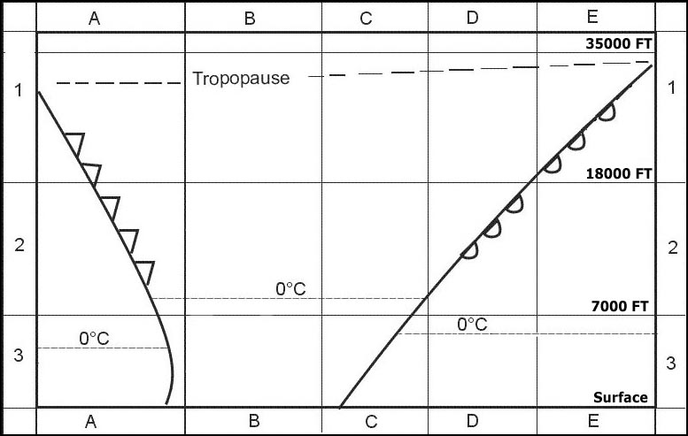
Question 220-5 : Which of the following statements about a primary radar are correct 1 target size will influence the maximum range2 detection of targets in the area close to the radar will be difficult3 precipitation may reduce the useful rangethe combination that regroups all of the correct statements is ?
1 2 3.
Ecqb04 november 20171, 3. 2, 3. 1, 2.
Question 220-6 : Ssr transponder mode s enhanced surveillancethe controller's information is improved by providing actual aircraft derived data such as ?
Magnetic heading indicated airspeed vertical rate and selected altitude.
Ecqb04 november 2017pressure altitude flight level flight number or aircraft registration and ground speed are basic data send by a mode c or s transponder enhanced surveillance consists of the extraction of additional aircraft parameters such as magnetic heading indicated airspeed vertical rate and selected altitudeLanding mass, aircraft turbulence category, computed approach speed. magnetic heading, altitude and identification. pressure altitude, flight level, flight number or aircraft registration, ground speed.
Question 220-7 : Ssr transponder mode s enhanced surveillanceautomatic extraction of an aircraft's parameters and their presentation to the controller will reduce their ?
Radio telephony workload and will free them to concentrate on ensuring the safe and efficient passage of air traffic.
Ecqb04 november 2017with enhanced surveillance mode s the controller's information is improved by providing actual aircraft derived data such as magnetic heading indicated airspeed vertical rate and selected altitude the automatic extraction of an aircraft's parameters and their presentation to the controller will reduce their rt workload and will free them to concentrate on ensuring the safe and efficient passage of air trafficthe reduction in radio telephony between the air traffic controllers and the pilots will reduce pilot workload and remove a potential source of errorAttention and may lead to routine errors. awareness of the situation and may lead to interpretation errors. workload but will increase radio-telephony exchanges.
Question 220-8 : Ssr transponder mode s enhanced surveillancethe reduction in radio telephony between the air traffic controllers and the pilots will ?
Reduce pilot workload and remove a potential source of error.
Ecqb04 november 2017with enhanced surveillance mode s the controller's information is improved by providing actual aircraft derived data such as magnetic heading indicated airspeed vertical rate and selected altitude the automatic extraction of an aircraft's parameters and their presentation to the controller will reduce their rt workload and will free them to concentrate on ensuring the safe and efficient passage of air trafficthe reduction in radio telephony between the air traffic controllers and the pilots will reduce pilot workload and remove a potential source of errorReduce pilot awareness of the situation and may lead to interpretation errors. increase attention but may lead to routine errors. reduce the static interferences experienced by gps receivers.
Question 220-9 : Airborne weather radar awr should be used with extreme caution when on the ground because ?
It can hurt the ground staff.
Ecqb04 november 2017It may interfere with the alignment of the inertial reference system. it can disrupt communication with the tower. it can disrupt the airport's radio-navigation systems.
Question 220-10 : The main disadvantage of using an airborne weather radar awr on the ground is ?
Shf waves it emits can damage tissues of the people on whom it radiates.
Ecqb04 november 2017Reflections on ground and buildings can overheat the radar and switch it off momentarily. reflections on ground and buildings are very strong and prevent to see potentially dangerous phenomena when align for take-off. its antenna can be damaged while taxiing, especially on rough runway and taxiway.
Question 220-11 : Which of the following is a complete list of airborne weather radar antenna stabilisation axes ?
Roll and pitch.
The airborne weather radar awr is normally mounted in the nose section and the centre postion is aligned with the fore aft axis of the aircraft the aerial regardless of the type is fitted on a gimbal system that stabilises the aerial with the horizon both in roll and pitch directions therefore regardless of the attitude changes of the aircraft the antenna is kept in the same attitude relative to the horizon this is to ensure that the radar picture is not distorted or lost during manoeuvres of the aeroplanePitch and yaw roll and yaw roll, pitch and yaw
Question 220-12 : In an airborne weather radar that has a colour cathode display increasing severity of rain and turbulence is generally shown by a change of colour from… ?
Green to yellow red magenta.
Airborne weather radardepending on the returning echoes the reflectivity of the area defines the amount of water droplets present therefore the differing intensity of expected precipitation is presented to the pilot with colour codesthe painted colours dependent on the water concentration are as follows colourwater concentrationexpected turbulencegreenlightnone or lightyellowmoderatelightredheavymediu mor severemagentaheavy or icesevereYellow to orange, red. green to red, black. yellow to amber, blue.
Question 220-13 : Considering a primary radar system what kind of aerials are used ?
One directional antenna both for transmitting and for receiving.
A primary radar is a conventional radar sensor that illuminates a large portion of space with an electromagnetic wave and receives back the reflected waves from targets within that spaceprimary radar is used to detect aircraft not equipped with a secondary radar transponderin order to achieve this function the primary radar uses a directional antennaa directional antenna or beam antenna is an antenna which radiates or receives greater power in specific directions allowing increased performance and reduced interference from unwanted sources ideally to use for air traffic control services to serve a large number of aircraftsAn omnidirectional antenna for transmitting, and a directional antenna for receiving. a directional antenna for transmitting, and an omnidirectional antenna for receiving. one directional antenna for transmitting and one for receiving.
Question 220-14 : What information may be displayed on an atc radar screen connected only to a primary radar system ?
Aircraft position only.
Refer to figurelearning objective 06203020101 explain that primary radar provides bearing and distance of targetsprimary radar is the simplest type of radar it refers to a system which emits pulses of electromagnetic energy then waits for any of those pulses to return and ifwhen they do it measures the time between emitting the pulse and receiving the reflected pulse which it can then use to calculate the distance from the target as the electromagnetic waves all travel at the speed of lightit does this whilst scanning the sky from side to side so each pulse targets a different area of the sky horizontally and by sending pulses many hundreds of times per second the radar can scan the region and get both a bearing and a distance to each target this can then be plotted on a display for the radar operator to seewith primary radar you can therefore only see locations of targets and can extrapolate their movements over time to get a rough idea of their speed if the operator is skilledother radar systems can provide more information than this ssr secondary surveillance radar which use a different method of radar operationAircraft altitude. aircraft position and ssr code. aircraft position, ssr code and altitude.
Question 220-15 : Airborne weather radar has been primarily developed to detect ?
The kinds of intense precipitation which are usually accompanied by turbulence.
Learning objective 06203030102 state that modern weather radars employ frequencies that give wavelengths of about 3 cm that reflect best on wet hailstonesairborne weather radars awrs have been created so that the pulses the emit reflect best off objects that are the same size as large water droplets hailstones one of the primary tasks of an awr system is to detect upcoming turbulence and bad weather so that the pilots can take necessary precautions or avoiding actionthe largest areas of turbulence come from cumulonimbus cb clouds which contain large droplets of water ice crystals and hail stones modern awrs are set up to have a wavelength of approximately 3cm so they bounce off these types of precipitation the most the radars have been tuned this way to make sure that more radar returns means that there is a higher chance of turbulence in that area usually the bigger the haildroplets the worse the turbulencethe radar pulses will always reflect off wet hail and large water droplets better than they will off smaller water droplets dry hail and ice crystalsAll kinds of frozen precipitation such as hail, snow and graupel. areas of wind shear and severe aircraft icing. areas of severe clear air turbulence.
Question 220-16 : An airborne transponder can provide coded reply signals in response to interrogation signals from ?
Ground secondary surveillance radar and from aircraft equipped with tcas.
A transponder xpdr is a receivertransmitter which will generate a response in the form of a coded pulse train upon proper interrogation the interrogation and reply being on different frequencies an advantage of the transponder is that it is capable of communicating with not only ssr equipment but also other airborne transponders whereby exhanging flight parameters aids the traffic collision avoidance system tcas between flying aircraftcivil aircraft may be equipped with transponders capable of operating in different modes mode a equipment transmits an identifying code only mode c equipment enables the atco to see the aircraft altitude or flight level automatically mode s equipment has altitude capability and also permits data exchangePrimary ground radar and from aircraft equipped with a transponder. ground secondary surveillance radar and from aircraft equipped with a mode a and c transponder. ground secondary surveillance radar and from primary ground radar.
Question 220-17 : A mode c transponder is able to report the pressure altitude in ?
100 ft increments.
Vertical performancemode c provides pressure altitude information in addition to identification and position information compared to mode a the transponder message is reported in 100 feet increments which should be considered in terms of vertical separaction by atcmode s has significantly better performance compared to mode c in terms of updating controller with altitude data the altitude may be reported with an accuracy of 25 feet100 m increments. 50 m increments. 25 ft increments.
Question 220-18 : Why should airborne weather radar awr systems be used with extreme caution when on the ground ?
People could be exposed to super high frequency shf radiation which if absorbed in large enough amounts can lead to tissue damage.
Avoid weather radar awr operation when personnel are within the area normally enclosed by the aircraft nose radome these radars can be the most dangerous critters in the cockpit awr work on super high freqencies shf to do what they do and without proper care that energy can be hazardous to you and others around the airplane ie tissues getting damaged The radar system may overheat and shut down due to the intensity of the returns from the ground, buildings, and surrounding terrain. the radar antenna can be easily damaged during ground-taxi manoeuvres (especially on uneven taxiways). the intense returns from the ground and surrounding terrain will not allow accurate identification of potentially hazardous weather when lined up for departure.
Question 220-19 : Which data can be determined and displayed by atc secondary surveillance radar ssr and primary surveillance radar psr systems ?
Psr target range and bearing ssr target range and bearing aircraft identification codes aircraft altitude selective addressing and full two way data link.
Primary surveillance radar psr the radar antenna rotates usually at 5 12 rpm emits a pulse of radio waveupon reaching an aircraft or other object the wave is reflected and some of the energy is returned to the antennathe psr output data uses polar coordinate system it provides range and bearing of the targets found in respect of the antenna positionnote that the range is the slant distance from the antenna and not the horizontal distancethe range is determined by the time difference of the emitted and received pulse the speed of propagation is the speed of light and the bearing is obtained from the antenna azimuththe rotation speed of the antenna is usually between 5 and 12 rpmthe antenna radiation patern is a narrow beam when seen from above and whith some approximation can be considered as a trapezium if seen from the side secondary surveillance radar ssr requires an airborne transponder which responds to the receipt of a pulse from a ground based antenna by transmitting a return signalbecause the transponder transmits a much stronger signal than that which is reflected off an aircraft in primary radar systemsreater range and reliability can be achieved with secondary radar and cheaper and more efficient ground equipment can be usedadditionally information such as altitude and a code can be added to the returned signal from the transponder which is then displayed on the operator’s screenin mode a the aircraft's transponder provides positive aircraft identification by transmitting a four digit code to the ground stationthe code system is octal that is each of the code digits may be any of the numbers 0 7there are thus 4096 possible four digit codesin mode c the aircraft's altitude derived from on board instruments is transmitted to the ground station in addition to the identityaircraft equipped with transponders supporting mode s are assigned a permanent identification which can be selectively addressed by the ground radarthis reduces problems of garbling between ssr returns from aircraft in close proximitymode s also offers a wider range of data to be transmitted including potentially an uplink of data from the ground station to the aircraftPsr: target range, bearing, and aircraft altitude. ssr: target range and bearing, aircraft identification codes, aircraft height, selective addressing, and full two-way data link. psr: target range. ssr: target range and bearing, aircraft altitude and height, selective addressing, and full two-way data link. psr: target range, bearing, and aircraft identification. ssr: aircraft identification codes, aircraft altitude, selective addressing, and full two-way data link.
Question 220-20 : The main factor which determines the minimum range that can be measured by a pulsed radar is ?
Pulse length.
Maximum theoretical rangepulse repetition frequency prf is the number of occurrences pulses each second the prf has a large significance on maximum range depending on how far the radar wishes to search for objects and what the visible range is the pulse repetition interval has to be set in a way to always allow the pulse to reach the range limits and returnthe maximum theoretical unambiguous range is calculate by the formula maximum range km = 300 000 ÷ prf × 2 in the above formula the range is given in kilometres and the prf is in pps the formula includes '300 000' which represents the number of km the light travels every second speed of light minimum theoretical rangepulse length or width is the measurement taken from the leading to trailing edge of a pulse and is a good indicator of the amount of power contained within the pulse generally longer pulses emitted from a radar return more power the minimum range capability of a radar is determined primarily by the pulse length or width minimum range km = 300 000 x pulse length 2Pulse amplitude. pulse frequency. pulse repetition rate.
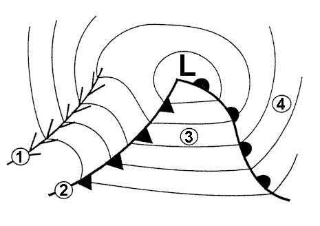
Question 220-21 : The airborne weather radar ?
May receive no reflections from a thunderstorm in an area behind a heavy rain shower.
Refer to figureweather attenuationthe weather radar display depends on signal returns the more intense the precipitation the less distance the radar can see through therefore when the radar echo is unable to make the two way trip through heavy precipitation a shadowing effect occursthe stronger the rainstorm the more radar energy will be scattered by weather attenuation in simple words radar attenuation or shadowing is simply the absorption or reflection of radar signals as the radar pulse penetrates an area of precipitation preventing that radar from detecting any additional cells that lie behind the first storm the awr is blind to whatever conditions may be lurking behind the thunderstorm in the area where the shadowing occurs conditions are unknownUses circular polarisation in order to reduce echoes of heavy showers. has a second transmitter working on a lower frequency in order to penetrate rain showers. has the possibility to detect clear air turbulence behind a thunder storm by measuring phase differences caused by the doppler effect.
Question 220-22 : What determines the operating mode a or c of the ssr transponder ?
The time interval between the pulses p1 and p3.
A secondary surveillance radar ssr system uses transmittersreceivers interrogators and transponders a pulse coded interrogation message is sent from the ground to the aircraft the transponder responds in accordance with the pulse coded interrogation in the form of a pulse train that is a series of pulses which carry the appropriate information the transmissions are achieved in the uhf band where all ground interrogation pulses are processed at a 1 030 mhz carrier frequency and all transponder responses are completed on the 1 090 mhz carrier channelthe two main modes of operation excluding mode s are mode a an interrogation to identify an aircraftmode c an interrogation to obtain an automatic height read out of an aircraftthree pulses p1 p2 and p3 are always transmitted to differentiate between interrogations the spacing between p1 and p2 is fixed at 2 s the spacing between p1 and p3 is 8 s for a mode a and 21 s for a mode c interrogation the transponder detects the time interval between the pulses p1 and p3 which determines the mode of interrogationThe position of the spi pulse. the difference in amplitude of the pulses p1/p3 and p2. the travel time of the pulses transmitted by the interrogator.
Question 220-23 : Airborne weather radar systems use a wavelength of approximately 3 cm in order to ?
Detect larger water droplets.
Typically the radar antenna is located in the nose of the aircraft signals from the antenna are processed by a computer and presented on a screen which may be viewed by the pilots droplet size is a good indicator of strong updrafts within cumulonimbus clouds and associated turbulence and is indicated on the screen by patterns colour coded for intensity it needs to be noted that the frequency band of the radio waves x band is selected not to detect any cloud small precipitation such as drizzle fog or wind as the droplets are too little or don’t exist some airborne weather radar systems may also be able to predict the presence of wind shearweather radars send directional pulses of microwave radiation on the order of a microsecond long using a cavity magnetron or klystron tube connected by a waveguide to a parabolic antenna the wavelengths of 1 – 10 cm are approximately ten times the diameter of the droplets or ice particles of interest because rayleigh scattering occurs at these frequencies this means that part of the energy of each pulse will bounce off these small particles back in the direction of the radar stationshorter wavelengths are useful for smaller particles but the signal is more quickly attenuated thus 10 cm s band radar is preferred but is more expensive than a 5 cm c band system 3 cm x band radar is used only for short range units and 1 cm ka band weather radar is used only for research on small particle phenomena such as drizzle and fog w band weather radar systems have seen limited university use but due to quicker attenuation most data are not operationalradar pulses spread out as they move away from the radar station thus the volume of air that a radar pulse is traversing is larger for areas farther away from the station and smaller for nearby areas decreasing resolution at far distances at the end of a 150 – 200 km sounding range the volume of air scanned by a single pulse might be on the order of a cubic kilometer this is called the pulse volumeObtain optimum use of the cosecant squared beam. transmit at a higher pulse repetition frequency for extended range. detect small as well as large cloud formations.
Question 220-24 : What beam is used in the mapping mode of an airborne weather radar that can utilise two different beam shapes ?
A cosecant squared beam effective up to a maximum of 50 nm to 60 nm.
The radar can has two modes weather and mapping the weather beam is used for detecting clouds and is a conical pencil beam with a width of 5 degrees and the mapping is for ground features and uses a fan shaped or cosecant squared beamthe directional properties of the radar produce side lobes one side lobe goes vertically down to the ground and is received back by the weather radar receiver this received signal produces a height ring on the display the ring indicates that the radar is working and appears at the approximate height of the aeroplane above the gound an aeroplane flying at 12000ft will have a permanent return at approximately 2nmweather radars produce a wide fan shaped beam cosecant square beam by placing parasitic elements in front of the radar dish to deflect the beam it is also referred to as the spoil beam the cosecant square beam provides a wider coverage than the conical beam at short range and its transmission pattern has the effect of compensating for range by sending more power to the top part of the beam which hits more distant objects the cosec beam works out to between 60nm and 150nm depending on type this is probably an old question that’s why the correct answer is from 50nm to 60 nm only beyond that range there is not enough power in the beam to produce reasonable returns so the more concentrated conical beam should be used instead in the weather mode the radar display of ground returns does not always look like the terrain would look like on a map hills can cause 'shadowing' at low altitude masking the terrain behind them and giving a false impression of water in arctic regions returns from ice can mask the true shape of the coastlineA cosecant squared beam effective up to a range of 150 nm. a pencil beam effective up to a maximum range of 60 nm. a pencil beam effective up to a range of 150 nm.
Question 220-25 : Ground secondary surveillance radar ssr equipment incorporates a transmitter and receiver that operate in the following frequencies ?
Transmits on 1030 mhz and receives on 1090 mhz.
A secondary surveillance radar ssr system uses transmittersreceivers interrogators and transponders a pulse coded interrogation message is sent from the ground to the aircraft the transponder responds in accordance with the pulse coded interrogation in the form of a pulse train that is a series of pulses which carry the appropriate information the transmissions are achieved in the uhf band where all ground interrogation pulses are processed at a 1 030 mhz carrier frequency and all transponder responses are completed on the 1 090 mhz carrier channel ground transmits on 1030 mhz and receives from aircraft on 1090 mhzTransmits on 1090 mhz and receives on 1030 mhz. transmits and receives on 1030 mhz. transmits and receives on 1090 mhz.
Question 220-26 : Ignoring pulse length the maximum pulse repetition frequency prf that can be used by a primary radar facility to detect targets unambiguously to a range of 200 nm is… pps = pulses per second ?
405 pps.
Prf pulse recurrence frequency is the number of pulses trasmitted in a second prf is one of the main factors that determine the maximum theoretical unambiguous range of a pulse radar the trasmitter must remain silent while the receiver is listening for echoes if the design maximum range is 200nm the receiver must be allowed to listen for the period of time fro when a pulse has been trasmitted untill it can go to 200nm and than return that is a round trip of 400 nm which would require a longer silent period than a radar whit a range of 100nm where the pulses have to travel only 200nm therefore we can say that a lower prf enables a longer maximum theoretical range max therorical range is inversly proportional to the prf the following formula may be used to calculate the max theoretical unambiguous range range in km = 300 000 ÷ prf x 2 or if we need to find the required prf based on a specific unambiguous range needed we can rearrange the formula prf = 300 000 ÷ range in km x 2 in our case we can apply the second one 1 nm = 1852 km so 200 x 1852 = 3704 kmprf = 300 000 ÷ 3704 x 2 prf = 40497 pps = approx 405 pps810 pps. 782 pps. 308 pps.
Question 220-27 : To double the effective range of a primary radar the power output must be increased by a factor of ?
16.
Primary surveillance radar psr works on the echo principle that uses strong transmitted signals at a known time these signals reflect from objects and the echoes are detected psr theoretical range depends among others on the power output of the radar transmitter range nm =4 power w if we double the range the power output required increases by 168. 2. 4.
Question 220-28 : The prime factor in determining the maximum unambiguous range of a primary radar is the ?
Pulse repetition frequency.
Pulse repetition frequency prf is the number of occurrences pulses each second the prf has a large significance on maximum range depending on how far the radar wishes to search for objects and what the visible range is the pulse repetition interval has to be set in a way to always allow the pulse to reach the range limits and returnthe maximum theoretical unambiguous range is calculate by the formula range km = 300 000 ÷ prf × 2 in the above formula the range is given in kilometres and the prf is in pps the formula includes '300 000' which represents the number of km the light travels every second speed of light note the minimum detection range of a pulse radar is determined primarily by the pulse lengthwidthSize of the parabolic receiver aerial. power output. height of the transmitter above the ground.
Question 220-29 : Airborne weather radars are generally based on the use of ?
Primary radar in the shf band.
Airborne weather radar awr is a primary radar system that is fitted to an aeroplane the selected frequency for awr is in the shf band and is 9375 ghz this has an associated wavelength of 32 cm awr must be optimised not to detect very small particles such as thin fog but to accurately identify rain particles in storms too small wavelengths will result in reflection from very small particles larger wavelengths result in the waves bending around particles of interestSecondary radar in the vhf band. secondary radar in the shf band. primary radar in the uhf band.
Question 220-30 : Which of the following types of radar equipment operate by means of the pulse technique 1 aerodrome surface movement radar 2 airborne weather radar 3 secondary surveillance radar ssr 4 aerodrome surveillance approach radar ?
1 2 3 and 4.
The pulse technique works by the transmission of pulse modulated signals the pulses are short interval high energy electromagnetic emissions this method is used by distance measuring equipment dme interrogatortransponder principle secondary surveillance radar ssr interrogatortransponder principle atc area or terminal surveillance radar echo reflection principle airport surface movement radar echoreflection principle airborne weather radar awr echo principle1, 2 and 4 only 2, 3 and 4 only 2 and 4 only
Question 220-31 : Which of the following phenomena is least likely to be detected by radar ?
Clear air turbulence.
Conventional weather radar cannot detect wind speed or turbulence directly it only detects solid and liquid objects above a threshold size the most turbulent areas of thunderstorms are also those areas that contain the most water and ice note that the areas in which the concentration of droplets decreases rapidly which are marked on the radar screen by a sharp fall in signal intensity are normally areas in which the most severe turbulence can be encountered these are areas in which the strong up going air currents are in close proximity to downward flowing currents and there is a strong risk of severe vertical wind shear these areas will be identified on the radar screen by a rapid change in appearance of the cloud return steep change in colors of the return steep color gradient if you identify this area on your radar screen avoid that area * green light precipitation slight turbolence* yellow or amber medium precipitationlight turbolence* red heavy precipitation medium to severe turbolence* magenta extremely high precipitation severe turbolenceso the weather radar is merely detecting the presence of water it is the pilot interpreting the picture who is really detecting the turbulenceclear air turbulence cat does not have condensated water in it and is therefore undetectable by conventional radar there are systems such as lidar that can detect cat but they generally not installed on aircraftWet snow and turbulence in cloud that has precipitation turbulence in cloud that has precipitation precipitation
Question 220-32 : What equipment works on the interrogatortransponder principle ?
Secondary surveillance radar ssr.
A secondary surveillance radar ssr system uses transmittersreceivers interrogators and transponders a pulse coded interrogation message is sent from the ground to the aircraft the transponder responds in accordance with the pulse coded interrogation in the form of a pulse train that is a series of pulses which carry the appropriate information the transmissions are achieved in the uhf band where all ground interrogation pulses are processed at a 1 030 mhz carrier frequency and all transponder responses are completed on the 1 090 mhz carrier channelAirborne weather radar (awr) aerodrome surface movement radar global positioning system (gps)
Question 220-33 : If the airborne weather radar system is fitted with an auto tilt function what does that mean the radar antenna tilt is automatically adjusted ?
Based on the altitude of the aircraft.
Modern aircraft are equipped with an automatic tilt function which sets the antenna tilt based on aircraft position altitude and range in weather mode the tilt is set to be above any terrain ahead based on the worldwide navigation database which supplies elevation data to the awr management computerTo tilt fully down when taxiing to reduce the possibility of injury to ground personnel. to track the areas with the greatest intensity of precipitation. based on the attitude of the aircraft.
Question 220-34 : To improve the detection of precipitation area s in eg thunderstorms in which the top of the cloud lies at or slightly above the level of flight the tilt setting should be ?
Lower when the aircraft climbs to a higher altitude.
If we know of the presence of thunderstorms then tilting the radar can be very useful to gather information about the strength of the thunderstorm and the levels at which it is worst if we are at a level just below the top of the thunderstorm it is likely that we have the tilt set to 0 or even 1 or 2 degrees in order to see the more violent lower section of the thunderstorm if we climb higher perhaps to overfly the storm then that same tilt setting will be looking higher up within the storm and will be seeing the ice crystals rather than the wet hail and large water droplets this is why we would set the tilt further downwards after making such a climbit is important to remember that there are other questions asking about the tilt setting during take off and climb out well of course the setting at that time of flight would be quite high to see the weather the aircraft is climbing towards and avoid clutter from ground returns after that though the tilt setting should gradually be reduced until the cruise and then in the descent gradually increased again to avoid ground returnsremember also that the radar is automatically stabilised so it follows the horizon plusminus any tilt not the aircraft attitude plusminus tiltHigher when the aircraft climbs to a higher altitude. lower when the selected range increases. higher when the selected range decreases.
Question 220-35 : When using airborne weather radar in the mapping mode in polar areas one runs the risk of ?
Mistaking the edge of coastal ice off shore for the real coastline.
Mapping mode is very useful to provide basic orientation relative to significant terrain features it may be used to distinguish land from water by detecting coastlines in map mode the receiver sensitivity is decreased to accomodate terrain characteristics instead of weather this mode enables identification of terrain features such as mountains coastlines bodies of water etc however it is important to note that off shore ice blocks may be mistaken for the real coastline with black areas in between being mistaken for the shadowed lee side of mountainsAurora borealis (polar light) causing false returns. getting a distorted picture because of ice reflection. underestimating distances because the cold seawater is causing super-refraction.
Question 220-36 : In order to provide an air traffic services ats surveillance service what minimum information must be provided to the controller on the surveillance system display indication of position and also ?
Any map information needed to provide the surveillance service and when available the aircraft identification and level.
To provide air traffic services ats surveillance service the minimum required information is position and map information which serves as a reference to airspace structure if the aircraft is equipped with a transponder depending on the mode of operation additional information may be provided mode a provides solely 2d position information that is presented on the screen of the controller in the horizontal plane mode c provides 3d position information that is presented on the screen of the controller in the horizontal plane with an altitude indication mode s in addition to the functions of mode c it provides data transmission as well which contains further aircraft derived dataAny map information needed to provide the surveillance service, aircraft speed, and (when available) the aircraft identification and level. level, speed, vertical speed, an overlay of the terrain, and (when available) the aircraft identification and destination. an overlay of the terrain, and the aircraft identification, speed, vertical speed, and level.
Question 220-37 : What are the potential dangers of operating an airborne weather radar awr on the ground radiated energy can ?
Harm human beings.
Avoid weather radar awr operation when personnel are within the area normally enclosed by the aircraft nose radome these radars can be the most dangerous critters in the cockpit awr work on super high freqencies shf to do what they do and without proper care that energy can be hazardous to you and others around the airplane ie tissues getting damaged Disturb radio communications with atc. disturb nearby airport navigation systems. cause misalignment of the aircraft’s air data and inertial reference system (adirs).
Question 220-38 : What is an advantage of an ssr with a ‘selective addressing mode’ over primary radar ?
It allows for unambiguous aircraft identification.
Mode smodes a and c are limited to 4096 available codes with an increasing volume of air traffic these systems become prone to interference mode s was invented to overcome these limitations 's' stands for selective addressing which means that a specific aircraft may be interrogated by the controller with selective addressing signal interference is avoided further ensuring system accuracyIt is independent from airborne(and space)based systems. its range is unrelated to its transmitting power. in case of a transponder malfunction, the ssr can be used as a primary radar.
Question 220-39 : When using awr in the climb what should be done ?
Tilt down.
Refer to figuremanual tilt managementthe tilt refers to the angle between the antenna beam centreline and the horizon the flight crew should regularly scan the area ahead of the aircraft in order to identify the strongest weather returns the flight crew should tilt the weather radar antenna up and down to obtain a correct display of a storm cell the flight crew must use the tilt knob to point the weather radar beam to the most reflective part of the storm cell use of the weather radar in accordance with the flight phase flight phase tilt control taxi away from ground personnel set the nd to the lowest range – as a rule set 15º up take off in the case of suspected adverse weather conditions manually and gradually tilt up to scan weather maximum 15º up in all other cases set the tilt to 4º up climb adjust the nd range as required and decrease the tilt angle as the aircraft climbs generally set the tilt 5º to 7º up initially possibly steadily reducing with altitude level flightcruise adjust the nd range as required regularly modify the tilt to scan weather ahead of the aircraft when the weather scan is completed adjust the tilt so that the ground returns appear on the top of the nd at high altitude tilt is set to 0º to 05º except under adverse weather conditions descent set the tilt to about 5º up approach set the tilt to 4º up – which prevents the display of too many ground returnsTilt right tilt up tilt left
Question 220-40 : What is the difference between ac all call and acs all call ?
Duration of p4 pulse.
Refer to figuremode ac all call consists of p1 p2 p3 and short p4mode ac and s consists of p1 p2 p3 and long p4 as you can see in the attached diagram the difference lies in the duration of p4 pulsesDuration p2 pulse. presence of p4 pulse. amplitude of p4 pulse.
Exclusive rights reserved. Reproduction prohibited under penalty of prosecution.