A free Premium account on the FCL.055 website! Read here
Sign up to unlock all our services and 15164 corrected and explained questions.
Question 86-1 : An aircraft is weighed and the following recordings are made nose wheel assembly scale 5330 kgleft main wheel assembly scale 12370 kgright main wheel assembly scale 12480 kgif the 'fixed items' amount to a mass of 1780 kg with a crew mass of 545 kg the empty mass as entered in the weight schedule is ? [ Result topography ]
30180 kg
Question 86-2 : If individual masses are used the mass of an aircraft must be determined prior to initial entry into service and thereafter ?
At intervals of 4 years if no modifications have taken place.
Easa air opsregulation eu no 9652012catpolmab100 mass and balance loading a during any phase of operation the loading mass and centre of gravity cg of the aircraft shall comply with the limitations specified in the afm or the operations manual if more restrictive b the operator shall establish the mass and the cg of any aircraft by actual weighing prior to initial entry into service and thereafter at intervals of four years if individual aircraft masses are used or nine years if fleet masses are used the accumulated effects of modifications and repairs on the mass and balance shall be accounted for and properly documented aircraft shall be reweighed if the effect of modifications on the mass and balance is not accurately known c the weighing shall be accomplished by the manufacturer of the aircraft or by an approved maintenance organisation d the operator shall determine the mass of all operating items and crew members included in the aircraft dry operating mass by weighing or by using standard masses the influence of their position on the aircraft's cg shall be determined e the operator shall establish the mass of the traffic load including any ballast by actual weighing or by determining the mass of the traffic load in accordance with standard passenger and baggage masses f in addition to standard masses for passengers and checked baggage the operator can use standard masses for other load items if it demonstrates to the competent authority that these items have the same mass or that their masses are within specified tolerances g the operator shall determine the mass of the fuel load by using the actual density or if not known the density calculated in accordance with a method specified in the operations manual h the operator shall ensure that the loading of 1 its aircraft is performed under the supervision of qualified personnel and 2 traffic load is consistent with the data used for the calculation of the aircraft mass and balance i the operator shall comply with additional structural limits such as the floor strength limitations the maximum load per running metre the maximum mass per cargo compartment and the maximum seating limit for helicopters in addition the operator shall take account of in flight changes in loading j the operator shall specify in the operations manual the principles and methods involved in the loading and in the mass and balance system that meet the requirements contained in a to i this system shall cover all types of intended operationsAt regular annual intervals. only if major modifications have taken place. at intervals of 9 years.
Question 86-3 : At the maximum landing mass the range of safe cg positions as determined from the appropriate graph in the loading manual is 206 ?
Forward limit 74% mac aft limit 270% mac.
Img146Forward limit 8.0% mac aft limit 27.2% mac. forward limit 8.6% mac aft limit 27.0% mac. forward limit 8.0% mac aft limit 26.8% mac.
Question 86-4 : At a given mass the cg position is at 15% mac if the leading edge of mac is at a position 6256 inches aft of the datum and the mac is given as 1345 inches determine the position of the cg in relation to the datum ?
64578 inches aft of datum.
The mac lenght is 1345 inches and the cg is at 15% of this distance back from the leading edge 15% of 1345 inches is 20175 inchesif the leading edge of the mac is at 6256 inches aft of the datum the cg will be at 6256 + 20175 = 645775 inches aft of the datum605.43 inches aft of datum. 20.18 inches aft of datum. 228.34 inches aft of datum.
Question 86-5 : The aeroplane has a take off mass of 58 000 kg at this mass the range of safe cg positions as determined from the appropriate graph in the loading manual is 207 ?
Forward limit 80% mac aft limit 265% mac.
Img147Forward limit 8.5% mac aft limit 26.1% mac. forward limit 8.2% mac aft limit 26.2% mac. forward limit 9.5% mac aft limit 26.1% mac.
Question 86-6 : When preparing to carry out the weighing procedure on an aircraft which of the following is not required ?
Drain all engine tank oil.
Basic empty mass is the mass of an aeroplane plus standard items such as unusable fuel and other unusable fluids lubricating oil in engine and auxiliary units fire extinguishers pyrotechnics emergency oxygen equipment supplementary electronic equipmentengine oil is included in the basic empty massDrain all useable fuel. drain all chemical toilet fluid tanks. removable passenger services equipment to be off-loaded.
Question 86-7 : An aircraft is weighed prior to entry into servicewho is responsible for deriving the dry operational mass from the weighed mass by the addition of the 'operational items' ?
The operator.
The operator is responsible for deriving the dry operational mass from the weighed mass by the addition of the 'operational items' prior the aircraft enter into serviceThe appropriate aviation authority. the aircraft manufacturer or supplier. the commander of the aircraft.
Question 86-8 : An aircraft may be weighed ?
In an enclosed non air conditioned hangar.
Weighing procedures normal precautions consistent with good practices in the weighing procedures such as checking for completeness of the aircraft and equipment determining that fluids are properly accounted for and the weighing is accomplished in an enclosed building preventing the effect of the wind should be providedIn a quiet parking area clear of the normal manoeuvring area. in an area of the airfield set aside for maintenance. at a specified 'weighing location' on the airfield.
Question 86-9 : A aeroplane has a landing mass of 53000kg the range of safe cg positions as determined from the appropriate graph in the loading manual is 208 ?
Forward limit 78% mac aft limit 270% mac.
Img172Forward limit 8.2% mac aft limit 27.0% mac. forward limit 7.3% mac aft limit 26.8% mac. forward limit 8.7% mac aft limit 26.8% mac.
Question 86-10 : The aeroplane has a mass of 61 000 kg in the cruise the range of safe cg positions as determined from the appropriate graph in the loading manual is 209 ?
Question 86-11 : An aeroplane must be re weighed at certain intervals where an operator uses 'fleet masses' and provided that changes have been correctly documented this interval is ?
9 years for each aeroplane.
Easa air opsregulation eu no 9652012catpolmab100 mass and balance loading a during any phase of operation the loading mass and centre of gravity cg of the aircraft shall comply with the limitations specified in the afm or the operations manual if more restrictive b the operator shall establish the mass and the cg of any aircraft by actual weighing prior to initial entry into service and thereafter at intervals of four years if individual aircraft masses are used or nine years if fleet masses are used the accumulated effects of modifications and repairs on the mass and balance shall be accounted for and properly documented aircraft shall be reweighed if the effect of modifications on the mass and balance is not accurately known c the weighing shall be accomplished by the manufacturer of the aircraft or by an approved maintenance organisation4 years for each aeroplane. whenever the certificate of airworthiness is renewed. whenever a major modification is carried out.
Question 86-12 : A flight benefits from a strong tail wind which was not forecast on arrival at destination a straight in approach and immediate landing clearance is giventhe landing mass will be higher than planned and ?
The landing distance required will be longer.
The strong tail wind helps carry the aircraft so less fuel is used with no delays on arrival and with a straight in approach less time spent on the approach procedure the plane will land with more fuel on board than expectedapproach and landing speeds are increased the landing distance required is longerThe approach path will be steeper and threshold speed higher. the landing distance will be unaffected. the approach path will be steeper.
Question 86-13 : The centre of gravity of an aeroplane is at 25% of the mean aerodynamic chord this means that the centre of gravity of the aeroplane is situated at 25% of the length of ?
The mean aerodynamic chord in relation to the leading edge.
Longitudinal cg location is normally expressed as a percentage of the mean aerodynamic chord mac from its leading edgeThe mean aerodynamic chord in relation to the trailing edge. the mean aerodynamic chord in relation to the datum. the aeroplane in relation to the leading edge.
Question 86-14 : To measure the mass and cg position of an aircraft it should be weighed with a minimum of ?
3 points of support.
2 points of support. 1 point of support. 4 points of support.
Question 86-15 : An aeroplane has a mean aerodynamic chord mac of 1345 inchesthe leading edge of this chord is at a distance of 6256 inches aft of the datumdefine the location of the centre of gravity of the aeroplane in terms of percentage mac if the mass of the aeroplane is acting vertically through a balance arm ?
1810%.
Leading edge mac is at 6256 inches aft of the datumthe centre of gravity is at 650 inches aft of the datum 650 6256 = 244 inches from leading edge mac 244 1345 x 100 = 1810 %85,50%. 75,60%. 10,50%.
Question 86-16 : The empty mass of an aircraft is recorded in ?
The weighing schedule and is amended to take account of changes due to modifications of the aircraft.
The empty mass of an aircraft is recorded in the weighing schedule and is amended to take account of changes due to modifications of the aircraftnormally the aircraft is weighed before entering in service every 4 years for individual aircraft every 9 years for fleet masses every time a modification takes place equipment installed or uninstalled as the weighing procedure is long and complex the operator is allowed to adjust the empty mass of an aircraft on the weighing schedule between to weighing procedureThe loading manifest. it differs from dry operating mass by the value of the 'useful load'. the weighing schedule. if changes occur, due to modifications, the aircraft must be re-weighed always. the loading manifest. it differs from the zero fuel mass by the value of the 'traffic load'.
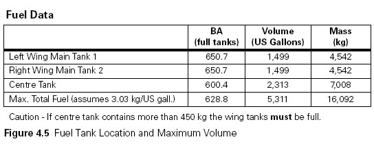
Question 86-17 : The maximum quantity of fuel that can be loaded into an aircraft's tanks is given as 400 us gallonsif the fuel density specific gravity is given as 079 the mass of fuel which may be loaded is ?
1196 kg.
1 ug gallons = 37854 litres400 usg x 37854 = 1514 litres1514 x 079 = 1196 kg1437 kg. 2302 kg. 1916 kg.
Question 86-18 : The maximum quantity of fuel that can be loaded into an aircraft's tanks is given as 2200 lif the fuel density specific gravity is given as 079 the mass of fuel which may be loaded is ?
1738 kg.
2200 x 079 = 1738 kg2785 kg. 2098 kg. 1798 kg.
Question 86-19 : The basic empty mass is 4960 kg the dry operating mass is 5220 kg and the zero fuel mass is 6040 kgif the take off mass is 7630 kg the useful load is ?
2410 kg.
Useful load = maximum take off mass dry operating massuseful load = 7630 kg 5220 kg = 2410 kg2670 kg. 1590 kg. 820 kg.
Question 86-20 : The basic empty mass is 4800 kg the dry operating mass is 5050 kg and the zero fuel mass is 6210 kgif the take off mass is 8010 kg the useful load is ?
2960 kg.
Useful load = the mass of the aircraft including everything and everyone contained within it at the commencement of take off the total mass of an aircraft ready for a specific type of operation excluding all usable fuel and traffic loaduseful load = take off mass dry operating massuseful load = 8010 kg 5050 kg = 2960 kg3210 kg. 1800 kg. 1160 kg.
Question 86-21 : Longitudinal cg location is normally expressed ?
As a percentage of the mac from its leading edge.
As a percentage of the mac from its trailing edge. with respect to the neutral point. with respect to the centre of pressure.
Question 86-22 : Given basic empty mass bem 1 200 kgbalance arm of bem 30 mcentre of gravity at bem 25% of maclength of mac 20 min the mass and balance section of the flight manual the following information is given position armfront seats 25 mrear seats 35 mrear hold 45 mfuel tanks 30 mthe pilot and one passenger ?
22 % of mac.
Com enannexephp annexe=com031 226jpgbasic mass cg was at 25% of the mean aerodynamic chord mac with an arm of 3 m the length of mac is 2m so the cg is at 05 m from leading edge mactake off mass cg = momentmass = 4300 1460 = 2945 mwith a cg located at 2945 m for take off it is at 0445 m from the leading edge mac 04452 x 100 = 2225% machwoarangitf please how do you found the '0445'm from the leading edge mac thank you at basic mass the cg is at 25% of the mac for a chord length of 2m and 3m aft of the datum 25% of 2m is 50 cm thus the leading edge of the mac is at 25m aft of datumcg location at take off will be at 2945 25m = 0445m aft of leading edge of the maccom enannexephp annexe=com031 226bjpg29 % of mac. 34 % of mac. 17 % of mac.
Question 86-23 : Given the following data distance from datum to centre of gravity 1253 mdistance from datum to leading edge 963 mlength of mac 800 mcalculate the centre of gravity in % mac mean aerodynamic chord ?
363% mac.
Position of the cg on the mac = distance from datum to centre of gravity distance from datum to leading edgeposition of the cg on the mac = 1253 963 = 29 m8 m is the lenght of the mac and center of gravity is located on the mac at 29 m8 m is 100% of the length 29m is at 29 x 100 8 = 3625 %47.0% mac. 63.4% mac. 23.1% mac.
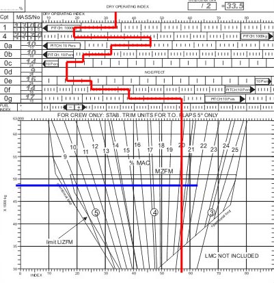
Question 86-24 : At reference to determine the dry operating index doi for a dom of 35000kg and a %mac of 14% 229 ?
Doi 40.
Img169Doi 35. doi 45. doi 50.
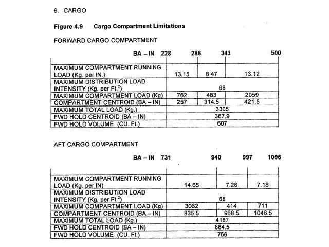
Question 86-25 : Which of the following combinations of compartment centroid and maximum load is correct 230 ?
8355 in and 3062 kg.
Img171take care we are talking in inches and in kilograms421.5 in and 3087 kg. 835.5 in and 4187 kg. 421.5 in and 2059 lb.
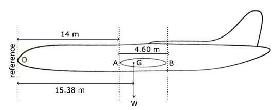
Question 86-26 : Given the following data calculate the cg as a %mac mean aerodynamic cord when 12000 n of last minute cargo is added to a hold 10 m from the datumaum all up mass 460000 nlemac leading edge mac 14 m from datummac 46 mcurrent cg 154 m from datum ?
275%.
Admin mass x arm = moment460000 n x 154 m = 7084000 nm12000 n of last minute cargo is added to a hold 10 m from the datum 12000 n x 10 m = 120000 nmnew mass is 472000 nnew moment is 7204000 nmcg position is now 7204000 472000 = 1526 min percentage of mean aerodynamic chord it is lemac is at 14 m therefore cg is 126m from lemac126 46 x 100 = 275% mac25%. 29.25%. 30.5%.
Question 86-27 : What are the standard masses used for crew ?
85 kg for flight crew 75 kg cabin crew including hand baggage.
Eu ops 1615 mass values for crew a an operator shall use the following mass values to determine the dry operating mass 1 actual masses including any crew baggage or2 standard masses including hand baggage of 85 kg for flight crew members and 75 kg for cabin crew members or3 other standard masses acceptable to the authorityb an operator must correct the dry operating mass to account for any additional baggage the position of this additional baggage must be accounted for when establishing the centre of gravity of the aeroplane85 kg for flight crew, 75 kg cabin crew, not including hand baggage. 88 kg for flight crew, 76 kg cabin crew, not including baggage. 88 kg for flight crew, 76 kg cabin crew, including baggage.
Question 86-28 : For the medium range twin jet the datum point is located 235 ?
540 inches forward of the front spar.
In bottom of the appendix you can read ' 21 datum point 540inches forward of front spar fs '540 cm forward of the front spar. on the nose of the aeroplane. at the leading edge of the mean aerodynamic chord (mac).
Question 86-29 : The chemical fluids used to charge the aircraft toilets are counted as ?
Part of the variable load.
Part of the payload. part of the basic empty mass. part of the under load.
Question 86-30 : For this question use annex ecqb 031 054 v2015 01 calculate the basic empty mass and the centre of gravity 240 ?
9684 kg and 1797 cm.
Ecqb03 july 2016 sorry we haven't yet recovered the annex we get only the question and the correct answer this is nice isn't it968.4 kg and 1707000 n.cm 9500 kg and 1707000 n.cm 9500 kg and 179.7 cm
Question 86-31 : For this question use annex ecqb 031 057 v2015 05 using the loading manifest in the annex determine the basic empty mass 240 ?
Question 86-32 : The bem of an aircraft is the basic empty weight of an aircraft without crew and items of removable equipment it is found in the ?
Weighing schedule at the last date of weighing.
Aircraft manual and includes unusable fuel and liquids in closed systems. loading manual and includes unusable fuel. operations manual and includes engine oil.
Question 86-33 : The mass of an aircraft is 2000 kg and 400 kg of freight is added to a hold 2 m aft of the present cg position the movement of the cg is ?
033 m aft.
Change of cg = mass added x distance from hold to cg new total masschange of cg = 400 x 2 2000 + 400 = 033 mwe add cargo aft thus the cg will move aft0.4 m forward. 0.4 m aft. 0.33 m forward.
Question 86-34 : Once the mass and balance documentation has been signed prior to flight ?
Acceptable last minute change to the load must be documented.
See easa air ops regulation no 9652012catpolmab105 mass and balance data and documentationSmall load changes are allowed without recalculation. no load alterations are allowed. acceptable last minute change to the load may be documented.
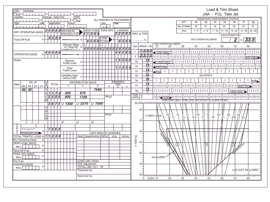
Question 86-35 : Using the loadsheet on the annex determine the underload and the difference between the maximum allowed tom and the actual tom the underload is 248 ?
3770 kg and the difference is 7170 kg.
Underload = allowed tl total tlunderload = 15000 kg 11230 kg = 3770 kgdifference mtom and actual tom actual tom = om + tlactual tom = 44400 kg + 11230 kg = 55630 kgdifference = mtom actual tomdifference = 62800 kg 55630 kg = 7170 kg3670 kg and the difference is 3770 kg. 3770 kg and the difference is 3770 kg. 4770 kg and the difference is 7170 kg.
Question 86-36 : A location in the aircraft which is identified by a number designating its distance from the datum is known as ?
Station.
Station is a location in the aircraft which is identified by a number designating its distance from the datumMoment. mac. index.
Question 86-37 : The centre of gravity of a body is that point ?
Through which the sum of the forces of all masses of the body is considered to act.
Where the sum of the external forces is equal to zero. which is always used as datum when computing moments. where the sum of the moments from the external forces acting on the body is equal to zero.
Question 86-38 : Assuming gross mass altitude and airspeed remain unchanged movement of the centre of gravity from the forward to the aft limit will cause ?
Increased cruise range.
With a forward cg the aircraft is 'nose heavy' he has a nose down moment thus the downforce on the tail on a steady flight must increasethe total aircraft weight increases and therefore more weight = more drag = more power = reduced maximum cruise rangewith an aft cg downforce on the tail on a steady flight is decreased less weight = less drag = less power = increased cruise rangeHigher stall speed. lower optimum cruising speed. reduced maximum cruise range.
Question 86-39 : Moment balance arms are measured from a specific point to the body station at which the mass is located that point is known as ?
The datum.
The datum is an imaginary vertical line chosen on the longitudinal axis of the aircraft specified by the designer from which all horizontal cg measurements are made 159in most cases the datum is located in the vicinity of the aircraft nose usually the firewallThe focal point. the axis. the centre of gravity of the aircraft.
Question 86-40 : The centre of gravity of an aircraft is that point through which the total mass of the aircraft is said to actthe weight acts in a direction ?
Parallel to the gravity vector.
Img145the sum of the aircraft weight acts through the center of gravity towards the earth's centerAlways parallel to the aircraft's vertical axis. at right angles to the flight path. governed by the distribution of the mass within the aircraft.
Exclusive rights reserved. Reproduction prohibited under penalty of prosecution.