A free Premium account on the FCL.055 website! Read here
Sign up to unlock all our services and 15164 corrected and explained questions.
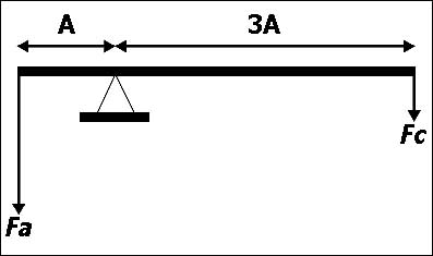
Question 93-1 : A 5 kg mass is located at the end of a plank at 4m of the pivot on the other end of 8m long what mass must be put for the plank to be in balance ? [ Deepen EASA ]
25 kg
Question 93-2 : A 5m rope is attached around a pivot a man a user pulls a force of 400 newton on the longest side of the rope located at 3 m of the pivot what load must be pull in the opposite direction to balance the forces ?
400 n.
400 n in one direction 400 n in the other800 n. 600 n. 200 n.
Question 93-3 : A 3 m long plank is on a pivot located at 1m of the left side a user applies a 400 n force on the end of the left side to be in balance what force must be apply on the opposite side ?
200 n.
1m x 400 n = 2m x n400 2 = 200 n400 n. 600 n 800 n.
Question 93-4 : Which pallet can be loaded in a hold whose maximum linear floor loading is 630 kgml ?
12 x 12m mass 700 kg.
We have to convert each container to a 1m running load 700 11 = 636kgml760 11 = 690kgml700 12 = 583kgml less than 630 kgml 760 12 = 633kgml1.2 x 1.2m, mass 760 kg. 1.1 x 1.1m, mass 700 kg. 1.1 x 1.1m, mass 760 kg.
Question 93-5 : Which of the following statements about loading is correct ?
Containers can be connected directly to the aircraft and each container has its own manifest.
Baggage and cargo can be loaded into standard size containers designed to fit and lock into the cargo compartment the containers have an individual maximum mass limit and an individual floor loading limit mass per unit aera each container has its own manifestBulk cargo loading requires much less ground personal than the loading of containers. live animals are never loaded as bulk cargo. pallets are mainly used on small aircraft and are strapped down.
Question 93-6 : Rush bags last minute baggage and cabin crew baggage is held inon ?
Question 93-7 : The maximum floor loading for a cargo compartment is given as 70 kgm²a package with a mass of 0126 ton is to be loadedassuming the pallet base is entirely in contact with the floor which of the following is the minimum size pallet that can be used ?
18 m².
126 kg 70 kgm² = 18 m²8.82 m². 0.48 m². 0.56 m².
Question 93-8 : Crew baggage is considered to be ?
Variable load.
Crew baggage is a variable load and is usually put in the cargo compartment as bulk loadPalletized load. containerized cargo load. forbidden cargo load.
Question 93-9 : Which of the following can be considered as bulk cargo ?
Baggage from late arrival passengers and crew hand baggage.
Palletised cargo. cargo on containers. live animals.
Question 93-10 : Which of the listed types of cargo can be found in a bulk cargo compartment ?
Late arrival and crew baggage.
Bulk cargo is loaded loose and restrained typically by a net ie this area of the hold does not use standard containers such as unit load devices ulds or pallets items that are loaded in bulk typically include rush bagslate arrival bagscrew bagspushchairs wheel chairs etcalthough live animals are sometimes loaded in bulk they can also be loaded in specialised containers such as for race horses cattle etc sometimes animals travel in the cabin such as guide dogs and certainly pet animals are in the cabin on private jets so although there is some merit for this answer option it does not always applyPalletised cargo. live animals. containerised cargo.
Question 93-11 : Palletised cargo ?
Consists of multiple cargo boxes on pallets stored in the cargo holds.
A pallet is essentially a large metal tray that fits into the aircraft and can be secured easily by latches in the aircraft's flooring the benefit of a pallet is that it can be used to carry large or odd shaped pieces of cargo indeed several pallets can be used together to carry larger items such as carsany cargo on the pallet must be secured however and this is normally done with straps or netting which is placed over the cargo and secured to the pallet looking at the answers 'has fallen out of use due to the lack of protection' > incorrect although a pallet does not offer the same protection as a unit load device uld it will always have a use for odd shaped or large cargo'consists of multiple cargo boxes on pallets stored in the cargo holds' > correct as described above and also shown in the figure'consists of passenger baggage on pallets stored in the cargo holds' > incorrect pallets are used for odd shaped or large cargo items passenger bags are loaded in uld's or loose in bulk'can be loaded without specific loading equipment' > incorrect the pallets and their cargo are heavy and large and require specialist lifting devices to place in and out of the aircraft considering a cargo aircraft the floor is also designed with special roller beds and ball bearings to allow the pallets to be moved inside the aircraftHas fallen out of use due to the lack of protection. consists of passenger baggage on pallets stored in the cargo holds. can be loaded without specific loading equipment.
Question 93-12 : Regarding the securing of traffic load which of the following answers is correct ?
During flight containers and pallets are permitted to remain on rollers within tracks provided they are secured by latches.
Containers are usually big on size there's rollers in the airplane to facilitate the movement of the cargo so they can be easily moved by hand while loading or unloading the airplanecontainers are allowed to remain on those rollers within tracks provided they are secured by latches that restrain them from movement during any stage of the flight as movement of the containers are very dangerous and cause movement of centre of gravity which can lead to serious circumstancesDuring rotation on take-off, the dangers of an unsecured load include possible damage to bulkheads and the forward shift of the cg to outside of the cg limits. unit load devices must be restrained with straps to the designated tie-down points in the cargo floor. traffic load must be restrained thoughout flight so that only the predictable movement of cg with fuel burn can occur.
Question 93-13 : Assuming a baggage compartment with a structural limitation of 32 lbsq ft a mass of 200 kg has to be distributed over an area of ?
128 m2.
As the answers option in m2 so we need to convert the limitation from lb ft2 to kg m21 lb = 0453 kg32 lb = 0453 x 32 = 145 kgaccording to limitation we can fit 145 kg in one square feetnow we need to know how many kg we can fit in one square meter1 m2 = 1076 ft2 kg that can fit in square meter = 145 x 1076 = 156 kg m2 to fit the package of 200 kg we need 200 156 = 128 m26.25 m2. 0.58 m2. 13.77 m2.
Question 93-14 : The maximum intensity floor loading for an aeroplane is given in the flight manual as 650 kg per square metre what is the maximum mass of a package which can be safely supported on a pallet with dimensions of 80 cm by 80 cm ?
416 kg.
There are two floor loading limits to be considered the distribution load intensity either floor area or contact area the running linear loadthe maximum distribution load intensity is the maximum static mass per unit area which the floor is designed to continuously carry and can be calculated by dividing the maximum load by the floor area it covers or the contact area maximum distribution load intensity = max load contact or floor areasolving the above the formula for max load we get max load = maximum distribution load intensity x floor area = 650 kgm2 x 080 m 2 = 416 kg101.6 kg 1 015.6 kg 41.6 kg
Question 93-15 : The floor of the main cargo hold is limited to 4 000 nm² it is planned to load a cubic container each side of which measures 05 m it's maximum gross mass must not exceed assume g = 10 ms² ?
100 kg.
Floor loads and aircraft weights are occasionally given in newtons n a newton is a unit of a force and 1 kg equates to 981 n or roughly 10 nthe conversion factor 'assume g = 10 ms²' means 'assume there are 10 n in a kilogram'thus the distribution load intensity can be converted from nm2 into kgm2 4 000 nm² 10 = 400 kgm2there are two floor loading limits to be considered the distribution load intensity either floor area or contact area the running linear loadthe maximum distribution load intensity is the maximum static mass per unit area which the floor is designed to continuously carry and can be calculated by dividing the maximum load by the floor area it covers or the contact area maximum distribution load intensity = max load contact or floor areasolving the above the formula for max load we get max load = maximum distribution load intensity x contact area = 400 kgm2 x 05 m 2 = 100 kg1 000 kg 500 kg 5 000 kg
Question 93-16 : Which one of the following shipments can be loaded in a cargo compartment with a floor loading of 70 kgm² all pallets are in direct contact with the cargo floor ?
600 kg on a pallet sized 3 m x 3 m.
Floor loading limit 70 kg m2check every shipment if exceed limitation or not a 500 1 x 1 = 500 kg m2 exceed the limit b 500 2 x 2 = 125 kg m2 exceed the limit c 600 3 x 3 = 667 kg m2 within the limit d 600 2 x 2 = 150 kg m2 exceed the limit500 kg on a pallet sized 1 m x 1 m 500 kg on a pallet sized 2 m x 2 m 600 kg on a pallet sized 2 m x 2 m
Question 93-17 : A container is loaded so that the floor contact area is 012 m² calculate the maximum mass of the container given that the maximum permissible floor load of the cargo compartment is 700 kgm² ?
84 kg.
Maximum permissible floor load 700 kg m2container contact area 012 m2maximum mass of the container = 012 x 700 = 84 kg139 kg 58 kg 169 kg
Question 93-18 : A container has a floor contact area of 144 m² given that the maximum permissible floor load of the cargo compartment which is 732 kgm² must be respected what is the maximum mass that can be loaded in the container ?
1054 kg.
Floor contact area 144 mmaximum permissable load 732 kg m2our container is 144 m2 and we can load 732 in 1 m2maximum mass that can be loaded in the container = 144 x 732 = 1054 kg508 kg 732 kg 1518 kg
Question 93-19 : A container has a base area of 144 m2 the container is loaded on two ground supports of negligible mass each having floor contact dimensions of 02 m x 12 mgiven that the maximum permissible floor load of the cargo compartment which is 732 kgm2 must be respected what is the maximum mass that can be ?
351 kg.
We need to find the area which is in direct contact with the floor both ground supports 2 × 12 × 02 = 048 m2the maximum permissible floor load is given 732 kgm2 convert this value to the area of the ground supports 732 kg 1 m2 × 048 m2 = 35136 kg closest answer = 351 kg1525 kg 1054 kg 175 kg
Question 93-20 : A box weighing 300 kg has dimensions of 1 m x 15 m x 06 m it needs to be loaded in a cargo hold compartment with a maximum running load of 2579 kgm indicate the side of the box that should be placed on the floor along the longitudinal axis of the aircraft ?
The side that is 15 m long.
The running load is limited in order to protect the aircraft's flooring for running load minimum length required = mass of the box kg limit kgm 300 2579 = 116 metresas this is more than one metre the box can only be placed on the 15 m long sideThe side that is 0.6 m long. the boxcannot be placed directly on the floor. the side that is 1 m long.
Question 93-21 : A cubic container whose sides all measure 08 m is planned to be loaded in a cargo compartment with a maximum running load of 1915 kgm the container shall be loaded on two ground supports of negligible mass having a length in the direction of the flight of 02 m eachgiven that the maximum running load ?
766 kg.
Maximum running load per meter = 1915 kgcontainer will be carried on two ground support each of them is 02 mcontainer contact with ground = 04 mmaximum mass of the container = 04 x 1915 = 766 kg1532 kg 1915 kg 383 kg
Question 93-22 : The floor loading of a cargo compartment is 732 kgm² of the options listed which is the smallest pallet size that is acceptable for loading a box of 806 kg ?
12 m x 12 m.
Floor loading each square metre can carry 732 kg loading box 806 kg = we need more than 1 square metrethis eliminates 2 answers immediately without touching the calculator 08 m x 08 m too small 10 m x 10 m too smallto calculate the minimum size of the pallet that can load 806 kg = 806 732 = 11 m2looking at the remaining answer options 12 m x 12 m = 144 m2 meets the requirements 14 m x 14 m = 196 m2 meets the requirements but is too bigsmallest pallet size that can be used 12 m x 12 m0.8 m x 0.8 m 1.0 m x 1.0 m 1.4 m x 1.4 m
Question 93-23 : Calculate the maximum mass that can be loaded on a pallet sized 12 m x 12 m to comply with a maximum running load of 1915 kgm ?
2298 kg.
Be careful with questions about running load & floor loading running load mass length so one dimensional floor load = mass area so two dimensionalin this question it is the running load that must be calculated the limit is 1915 kg for every metre the pallet is 12 m long so 1915 x 12 = 2298 kg1596 kg 4596 kg 2757 kg
Question 93-24 : The structural limitation of a baggage compartment is 50 lbft2 a load has a mass of 320 kg and has to be distributed over an area of at least ?
131 m2.
As the answers option in m2 so we need to convert the limitation from lb ft2 to kg m21 lb = 0453 kg 50 lb = 0453 x 50 = 2265 kg according to limitation we can fit 2265 kg in one square feet now we need to know how many kg we can fit in one square meter 1 m2 = 1076 ft2 kg that can fit in square meter = 2265 x 1076 = 244 kg m2 to fit the package of 320 kg we need 320 244 = 131 m214.11 m2 0.76 m2 6.4 m2
Question 93-25 : The floor limit of an aircraft cargo hold is 5 000 nm2 it is planned to load up a cubic container measuring 04 m of side it's maximum gross mass must not exceed assume g = 10 ms2 ?
80 kg.
With these questions a good knowledge of the following formula is required mass = floor load x area area = mass floor load floor load = mass areaalways be careful especially before starting on the calculator to check the units used by the examiner in this case they are given as nm2 assuming g = 10 ms2the floor limit is 5000 n per 1 m2 the area of the container is 04 x 04 = 016 m2 mass = floor load x area mass= 5000 x 016 = 800 n = 80 kg320 kg 800 kg 32 kg
Question 93-26 : Considering the methods of loading cargo which of the following answers is correct ?
Containers lock directly into the aircraft’s restraint system and have their own manifest.
A unit load device uld is a container used to load luggage freight and mail on wide body aircraft and specific narrow body aircraft it allows a large quantity of cargo to be bundled into a single unit since this leads to fewer units to load it saves ground crews time and effort and helps prevent delayed flights each uld has its own packing list or manifest so that its contents can be trackedthe most important purpose of a uld is to secure cargo during flight the safety of the plane and its passengers comes first every timeuld also allows eliminate the need for manual loading and unloading protect cargo contents so that goods arrived undamaged maximise the use of the aircraft’s cargo space the fast and easy transfer of cargo between planes in transitto prevent the ulds moving around during flight and potentially damaging the aircraft the plane has loading and restraint systems these interface directly with a uld effectively locking the uld into place so it becomes part of the aircraftcorrect answer container lock directly into the aircraft’s restraint system and have their own manifestBulk cargo is secured onto unit load devices using nets. compared to pallets, bulk cargo is quicker to load and requires fewer ground personnel. pallets are used on smaller aircraft and must be strapped down to tie-down points.
Question 93-27 : Which of the listed containers is acceptable for loading in a cargo compartment with a maximum permissible running load of 630 kgm container w base dimensions 11 m x 11 m loaded with 700 kg container x base dimensions 11 m x 11 m loaded with 760 kg container y base dimensions 12 m x 12 m loaded ?
Container y.
Maximum permissible running load 630 kgmwe check options one by one container w 700 11 = 636 kgm exceeding limits wrong container x 760 11 = 690 kgm exceeding limits wrong container y 700 12 = 583 kgm within limit correct answer container z 760 12 = 633 kgm exceeding limits wrongContainer x container w container z
Question 93-28 : Calculate the minimum required floor contact area for a load of 0126 metric tons in order to avoid exceeding the cargo compartment’s maximum permissible floor load of 70 kgm2 ?
180 m2.
1 ton = 1 000 kg so 0126 tons × 1 000 kgt = 126 kgwe have a load of 126 kg and a floor limit of 70 kg m2 we will need more than a square metre but less than 2 m2 2 x 70 = 140 and we only have 126 kg before touching the calculator look at the answers 882 m2 looks much too big an area 021 m2 under a square metre too small 056 m2 under a square metre too small 180 m2 looks likely so now check on the calculator 126 70 = 18 m28.82 m2 0.56 m2 0.21 m2
Question 93-29 : The maximum load per running metre of an aeroplane is 350 kgm the width of the floor area is 2 metres the floor strength limitation is 300 kg per square metre which one of the following crates can be loaded directly on the floor ?
A load of 400 kg in a crate with dimensions 12 m × 12 m × 12 m.
Floor strength limitation 300 kg m2maximum load per running meter 350 kg mnote that the dimensions are given as 'length x width x height' and floor strength = load kg surface area m2 where surface area = length x widthrunning load = load kg length of load m we have to analyze the options a load of 700 kg in a crate with dimensions of 18 m x 14 m x 08 m wrong floor strength = 700 18 x 14 = 2778 kgm2running load = 700 18 = 3889 kgm will exceed the maximum load per running meter 350 kg m a load of 500 kg in a crate with dimensions of 15 m x 1 m x 1 m wrong floor strength = 500 15 x 1 = 3333 kgm2running load = 500 15 = 3333 kgm will exceed the strength load limitation of 300 kg m2 a load of 400 kg in a crate with dimensions of 14 m x 08 m x 08 m wrong floor strength = 400 14 x 08 = 357 kgm2running load = 400 14 = 2857 kgm will exceed the strength load limitation of 300 kg m2 a load of 400 kg in a crate with dimensions of 12 m x 12 m x 12 m correct floor strength = 400 12 x 12 = 27778 kgm2 => within limitsrunning load = 400 12 = 3333 kgm => within limitsA load of 700 kg in a crate with dimensions 1.8 m × 1.4 m × 0.8 m. a load of 400 kg in a crate with dimensions 1.4 m × 0.8 m × 0.8 m. a load of 500 kg in a crate with dimensions 1.5 m × 1 m × 1 m.
Question 93-30 : A box weighing 105 kg is loaded into the cargo compartment calculate the smallest required floor contact area of this box to avoid exceeding the maximum floor load of 600 kgm2 ?
0175 m2.
Smallest contact area = box mass maximum floor load = 105 600 = 0175 m20.155 m2 0.571 m2 0.157 m2
Question 93-31 : A piece of cargo of 13 m2 and a mass of 600 kg is loaded on two pallets with dimensions of 02 m x 12 m each considering that the maximum area loading equals 367 kgm2 can this cargo be transported in the cargo hold ?
No because the maximum area load is exceeded.
The question only states the maximum area load therefore we assume that the other limits such as maximum running load are not violatedthe mass of the cargo will be distributed over the area of the pallets pallet area = 2 x 02 x 12 = 048 m2cargo mass = 600 kg which will be distributed over 048 m2 area load = 600 kg 048 m2 = 1 250 kgm2 the maximum area load will be exceeded by 883 kgm2Yes, only if the pallets are placed laterally on both ends of the cargo. yes, if the pallets are aligned longitudinally. yes, because the base area of the cargo sufficiently distributes the load to comply with the maximum area load.
Question 93-32 : A container with a base area of 5 x 5 ft is loaded into a cargo compartment the maximum running load of the compartment is 85 lbfeet the maximum possible weight of the container is ?
425 lb.
Use the following formula maximum possible mass container = maximum running load compartment x longest side container maximum possible mass container = 85 lbft x 5 maximum possible mass container = 425 lb85 lb 850 lb 2125 lb
Question 93-33 : Which one of the following statements is true ?
Cargo may be loaded into a passenger compartment provided that it is secured according to applicable regulations in eu ops 1.
Easa air ops amc2 catopmpa160 stowage of baggage and cargo carriage of cargo in the passenger compartmentthe following should be observed before carrying cargo in the passenger compartment a for aeroplanes 1 dangerous goods should not be allowed and 2 a mix of passengers and live animals should only be allowed for pets weighing not more than 8 kg and guide dogs b for aeroplanes and helicopters 1 the mass of cargo should not exceed the structural loading limits of the floor or seats 2 the numbertype of restraint devices and their attachment points should be capable of restraining the cargo in accordance with applicable certification specifications and 3 the location of the cargo should be such that in the event of an emergency evacuation it will not hinder egress nor impair the crew’s view even if you are not familiar with the eu ops 1 regulation the remaining options are cleary incorrectThe floor loading limit is equal to mtom-bem. running load is the maximum load tolerated per unit of area (i e kg/m2). the orientation of a specified cargo container within a cargo hold will not affect the running load.
Question 93-34 : The maximum running load of the aft cargo hold of an aeroplane is 1650 kgm assume the standard mass of the proposed pallet is 120 kg and 2299 kg of baggage have to be loaded in the aft cargo hold which of the following pallets length x width should be used in order to comply with the running load ?
148 m x 146 m.
Maximum running load is the total load permitted per unit of the fuselage length and is calculated by dividing the mass by the length of the load along the aircraft fore and aft axis max running load = load lengththe load consists of the proposed pallet and the baggage mass load = 120 kg + 2299 kg = 2419 kgsolving the above formula for length we get the smallest pallet length which does not exceed the max running load length = 2419 kg 1650 kgm = 147 mthus only two dimensions of the pallet which do not exceed the max running load limit could be correct 148 m x 146 m and 150 m x 147 mhowever the question asks for the optimum pallet size which occupies the least possible area in the aft cargo hold without exceeding any running load limit of course so compare the two areas that each one pallet dimensions occupy a pallet size of 148 m x 146 m covers an area of 216 sqm a pallet size of 150 m x 147 m covers an area of 22 sqmtherefore the correct dimensions which both comply with the maximum running load limit and optimise best the space in the cargo hold are 148 m x 146 mnote the one of the dimensions should be more than 147 m otherwise running load limit will be exceeded1.50 m x 1.47 m 1.45 m x 1.44 m 1.43 m x 1.40 m
Question 93-35 : A cubic container has a length of 09 m the maximum mass that can be loaded in this container without exceeding the maximum permissible floor load of 240 kgm2 is… ?
19440 kg.
Floor loading limits are specified by the manufacturers and must be observed by the operators there are two limits to consider the maximum distribution load intensity or maximum permissible floor load the maximum linear load or maximum permissible floor running loadthe maximum distribution load intensity is the maximum static mass per unit area which the floor is designed to continuously carry the distribution load intensity can be calculated by dividing the load by the floor area it covers or the contact area load intensity = load floor area covered or contact areathe floor area that is covered by the cubic container is 09 m x 09 m = 081 m2thus the maximum mass that can be loaded in the cubic container is max load = max load intensity x floor area covered = 240 kgm2 x 081 m2 = 1944 kg329.21 kg 174.96 kg 296.29 kg
Question 93-36 : Which of the following loading methods is recommended for the transport of unconventional cargo ?
Large and irregularly shaped cargo should be loaded as palletised cargo.
The freight is secured in unit load devices ulds such as containers and pallets or restrained with nets as bulk cargo to stop shifting in flight because shifting loads would affect the cg position quite possibly causing an accident or damage to the airframe from insidepallets and load spreading devices make freight handling easier and also act to spread the load reducing the problems arising from floor distribution load and running load limitswhere the freight dimensions are unsuitable large and irregularly shaped for container uld pallets with load spreading bars are used the freight is secured with a cargo net and covered with a fire containment blanket if requiredthus large and irregularly shaped cargo should be loaded as palletised cargoLarge and irregularly shaped cargo can only be loaded in cargo-only aircraft. large and irregularly shaped cargo can best be loaded in containers. large and irregularly shaped cargo is ideally stored as bulk cargo.
Question 93-37 : During take off the load is suddenly sliding and moving backwards what happens to the aircraft's cg and stability ?
Cg moves aft and stability decreases.
The total mass of the aircraft can be said to act through one point called the centre of gravity cg and the total lift acts through the centre of pressure cp the relative positions of the cg and cp affect the longitudinal stability of the aircraft in practice the cg is usually forward of the cp thus the more forward the cg the more stable the aircraft in pitch some stability in pitch is desirable but not too muchaircraft manufacturers determine a safe range for the cg the aft limit is usually just in front of the centre of pressure but it provides less stability than that provided by the forward limitthe position of cg is established by separately considering the empty aircraft and the items of load and fuel the turning force or moment of each around a datum is calculated and then totalled to find where the total mass acts ie the cg positionthe moment is determined by the total mass and the distance of the each item from the datum moment = mass x arm and the cg position is determined by the total moment divided by the total mass cg = total moment total mass the greater the distance from the datum arm the greater the moment thus the more aft the cg position for a given masssince the load is suddenly sliding and moving backwards the distance between the sliding load and the datum increases so its increased moment will increase the total moment too thus the cg position will move aftCg moves forward and stability decreases. cg moves forward and stability increases. cg moves aft and stability increases.
Question 93-38 : Regarding the handling of the cargo which statement is correct ?
Containers provide better protection than pallets against damage to the cargo items.
The freight is secured in unit load devices ulds such as containers and pallets or restrained with nets as bulk cargo to stop shifting in flight because shifting loads would affect the cg position quite possibly causing an accident or damage to the airframe from inside pallet and load spreading devices make freight handling easier and also act to spread the load reducing the problems arising from floor distribution load and running load limits containers are sealed metal boxes and have a number of advantages such as easier loading of the cargo into the container and easier loading of the container onto and off the aircraft other benefits include better protection against weather and damage plus prevention of unauthorised access to the contents where the freight dimensions are unsuitable for container ulds pallets with load spreading bars are used and the freight is secured with a cargo net and covered with a fire containment blanket if required pallets are more flexible in terms of what they can accommodate odd shaped items but whatever you put on them are more vulnerable to damagePallets offer better protection than containers against damage to the aeroplane caused by cargo items. containers can be used only in cargo aeroplanes, while pallets can also be used in passenger aeroplanes. containers have a lighter weight structure when compared to pallets with the same floor dimension.
Question 93-39 : The maximum permissible floor loading for a cargo compartment in an aircraft is given as 170 kg per square metre a package with a mass of 374 kg is to be loaded assuming the pallet base is entirely in contact with the floor which of the following is the minimum size pallet that can be used ?
16 m x 14 m.
There are two floor loading limits to be considered the distribution load intensity either floor area or contact area the running linear loadthe maximum distribution load intensity is the maximum static mass per unit area which the floor is designed to continuously carry and can be calculated by dividing the maximum load by the floor area it covers or the contact area maximum distribution load intensity = max load min contact or floor areasolving the above the formula for min floor area we get min floor area = max load maximum distribution load intensity = 374 kg 170 kgm2 = 22 m2the question asks for the minimum pallet size that can be used so the only pallet dimensions which are within limits equal or more than 22 m2 and conform the smallest in size pallet are 16 m by 14 m 16 x 14 = 224 m2 1.6 m x 1.5 m 1.45 m x 1.45 m 1.8 m x 1.4 m
Question 93-40 : What is correct regarding methods for cargo loading ?
Oversized cargo is best loaded in pallets.
The freight is secured in unit load devices ulds such as containers and pallets or restrained with nets as bulk cargo to stop shifting in flight because shifting loads would affect the cg position quite possibly causing an accident or damage to the airframe from insidepallets and load spreading devices make freight handling easier and also act to spread the load reducing the problems arising from floor distribution load and running load limitswhere the freight dimensions are unsuitable large and irregularly shaped for container uld pallets with load spreading bars are used the freight is secured with a cargo net and covered with a fire containment blanket if requiredpalletised cargo avoids any movement during the flight and is a quicker method of loading the aircraft than bulk cargoContainers need their own manifest, while pallets don’t. bulk cargo needs less personnel to be loaded. containers can be used only in cargo aircraft, while pallets can also be used in passenger aircraft.
Exclusive rights reserved. Reproduction prohibited under penalty of prosecution.